Continuing the discussion from 2026 SOTA Challenge (Part 1) - #100 by F5JKK.
Previous discussions:
Continuing the discussion from 2026 SOTA Challenge (Part 1) - #100 by F5JKK.
Previous discussions:
Only to the nearest 25m – a bomb might miss its target!
Google Maps tends to show latitude and longitude coordinates with 15 decimal places. If that were true, it would represent a precision level down to the sub-atomic scale, to within ~0.1nm (~1 Angstrom). It should of course round it to the least accurate of its input data.
Poutine NO
Poutine? A popular Canadian dish of chips and cheese curds topped with a hot brown gravy? You say, No ?
Yes I love this Quebecois (VE2) dish of chips and cheese curds topped with a hot brown gravy ![]()
You need a bigger bomb. A B41 would make render a 25m error “insignificant”.
A Czar Bomba would lower the whole range of mountains!
Anyway, back to the locator: I thought the rule was that the first two letters (the “field”) was in upper case and subsequent letters were in lower case, like AB01cd23ef45 but perhaps that has been superceded?
No, the alternating case just makes it easier for humans to read.
Well the “rule” that I learned preceded the large scale use of computters, and after all the locator was intended for the use of humans - and hams!![]()
Well, that will make a change. Instead as activator being asked what the WAB square is or whether I am near a trig, the activator will be asking for the locator square.
And I am convinced many casual chasers won’t know theirs off by heart and will have to look it up.
But it will become the norm after a while that a 2/70 SSB/CW activator will ask for your locator…
Ham2K Polo makes use of export templates. I use it to include RST in the comment field.
And I am convinced many casual chasers won’t know theirs off by heart
I think on 2m/70cm ssb and cw regular operators would know this and sota chasers venturing there would have probably read this topic and be prepared.
Im surprised noone has suggested using What three words as a locator. Maybe they dont want to face the wrath of the management team ![]()
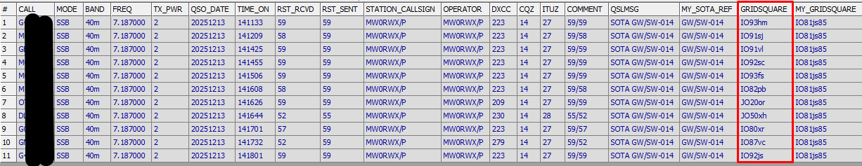
On the HamPolo2K app, the Grid (6 chars) is automatically populated from QRZ but not visible on the logging page.
When clicking on [more] the QSO details become visible. There, the entry can be corrected/overwritten as needed before returning back to the main logging page.
The ADIF output using the SOTA template contains the Grid by default as per example of a recent (non 2/70) activation in Wales, so I think HamPolo2K should work fine as is in support of the challenge.
just as it was up to about 20 years ago or less.
Want to know where you are? There’s an app for that
Dumb question: Linear Sats are SSB/CW. Surely this is the easiest way to max out the distance multiplier. Will linear sats be allowed as part of the challenge?
Will there be a results page on Sota Challanges tab?
Yes, it will go live on Jan 1
I am interested by this challenge having never worked 2m SSB or CW. My CW is very basic. What is the best way to ask for the 6-character grid location in CW?