Friday 2 December 2022
Setting off from home rather early , I caught the first train of the day into Carlisle, and after a quick change onto the West Coast mainline I was in Oxenholme by 0820. It was a a cold, damp and misty start to the day but the forecast for the next few days was for generally settled weather and so I was looking forward to grabbing a few winter bonus summits.
My bike was fully loaded – panniers front and back, and a small daysack ontop of the rack. For previous bike tour SOTA excursions in summertime I have carried a pair of fell running shoes for the hill walking segments; however, with some steep grassy slopes and slippery underfoot conditions expected I opted for my usual Altberg boots – which occupied a whole front pannier bag to themselves. Radio equipment consisted of two handhelds, a SW-3B CW radio, linked-dipole (20m and 40m), flowerpot antenna and 7m telescopic pole (plus various batteries, telescopic antennas and cables).
Camping equipment consisted of a 3F UL-Gear Lanshan-1 (I much prefer my Hilleberg Akto for winter camping, but this was an effort to save on weight and space); a pocket rocket gas stove and PHD Sleeping Bag (the extra warmth balancing out the 3-season tent). I also carried a lightweight Rab bivy bag in case the tent failed. A pair of trekking poles and various other bits (sleeping mat, sleeping clothes etc) completed the setup, and meant I was quite heavily weighed down.
The bike is a titanium Airborne Carpe Diem frame with steel fork and handmade wheels.

Crossing the M6
After leaving Oxenholme the road immediately started climbing, past the base of Lambrigg Fell and across the M6, where I paused to admire the view of the Howgills. I had passed the base of the Howgills on the train – and it seemed an awfully long time before the train came to a halt at Oxenholme, knowing I would need to cycle all the way back. Nevertheless, the going was good, and it was all downhill now to the book town of Sedberg (it is called a book town, but tghere are not that many book shops).
A sailed straight through Sedbergh, and onto the A683 heading towards Kirby Stephen, after a few km I drew to a halt at the Cross Keys Inn and got ready to start walking. I had a quick change out of cycling shoes and into walking boots, and triple checked that my radios were in my backpack. I struggled to locate my compass in my panniers, but I was eventually ready to go, and crossed the footbridge over the River Rawthey, beginning the climb up a grassy slope to Cautley Spout waterfall. I was glad I had brought a pair of trekking poles with me to help with the pull up the steep grassy slope, and my choice of footwear also proved wise.

Cautley Spout WaterFall
The weather was overcast and cool, with an occasional short shower of rain, but the wind was fairly slack. Climbing past the water fall the track heads alongside Force Gill before eventually turning onto the summit of The Calf (G/NP-013).
The Howgills are a favourite walking spot for me – lovely grassy hills with plentiful spots for wild camping (and lots of good water sources). Bing central between Lakeland and the Yorkshire Dales, the views in all directions are great – from Great gable in the West to the Yorkshire Three Peaks in the East.

Summit of The Calf
At the trig point I readied my handheld radio and called CQ on 2m at 1141 GMT, GW4ZPL was first to respond, followed by a S2S with G4YTD/P on G/LD-030 (Black Combe) – we had a good talk about Buffalo shorts, which we were both wearing/ Third contact was 2W0OLWF/P on GW/NW-076 and the fourth contact was 2E0MIX. There followed a good number of contacts, concluding with MW-PJE on GW/NW-001 (Snowdon).

The interlocking spurs of Bowderdale
It was getting chilly so I moved off the summit at about 1210BST, heading along a clear track about a kilometre before turning due east, leaving the track to head down to Bowderdale Head. A faint rack leads up the western flacks of Yarlside, starting at Bowderdale Head, and giving great views along the valley. The route here was easier than I expected and I was soon on the summit of Yarlside (G/NP-019). I turned on the radio to hear M0RWX/P on Aye Gill Pike (G/NP-023) – just across the Garsdale valley from me. After quick chat I moved onto my own frequency and called CQ, making contacts with G6LKB and M7MCG. The contacts dried-up, and so I broke into a QSO between M0RWX and 2W0LWF/P to achieve my fourth contact. 2W0LWF/P was still on GW/NW-076, giving me a second S2S with him that day. Afinal contact with 2E0MIX was made giving five in total. I was starting to feel the chill now, and knowing that I wanted to cover some distance before dusk, I headed off the hill at 1310 GMT.

Yarlside summit - with Lakeland on the horizon (Great Gable was clearly in view)

Back at the bike
The descent back the bicycle was quick, and I was changing into my cycling shoes well before 1400 GMT – the time I had originally alerted for Yarlside. Back on the bike, I retraced my route to Sedbergh where I bout some hot food at the local Spa shop, before starting the cycle ride East along the Garsdale valley. I paused at the viewpoint above Sedbergh – noting that I had crossed this point on a long distance walk earlier in the year.

A pause at the viewing point - crossed on foot earlier in the year
The cycle eastwards, in the falling light of the afternoon was lovely with the Clough river keeping my company and the steep walls of Bough Fell and Aye Gill Pike to the north and south. I have cycled this was several times before on cycle tours – usually heading towards Hawes and on towards the east. Today I turned off the road at Garsdale head to start the steep climb onto the old coal road. It was now 1600 GMT, the sun had set at 1550 GMT so it was getting dark as a paused for a photograph back down the valley.

Garsdale in falling light
Climbing up the coal road it was now properly dark, with my bike lights on a low setting to preserve battery power. The route along the coal road was long and steep – a really hard slog at the end of the day. Passing the spot height of 535m the worst of the climb was behind me, and I began looking out for the turn-off onto the bridleway.
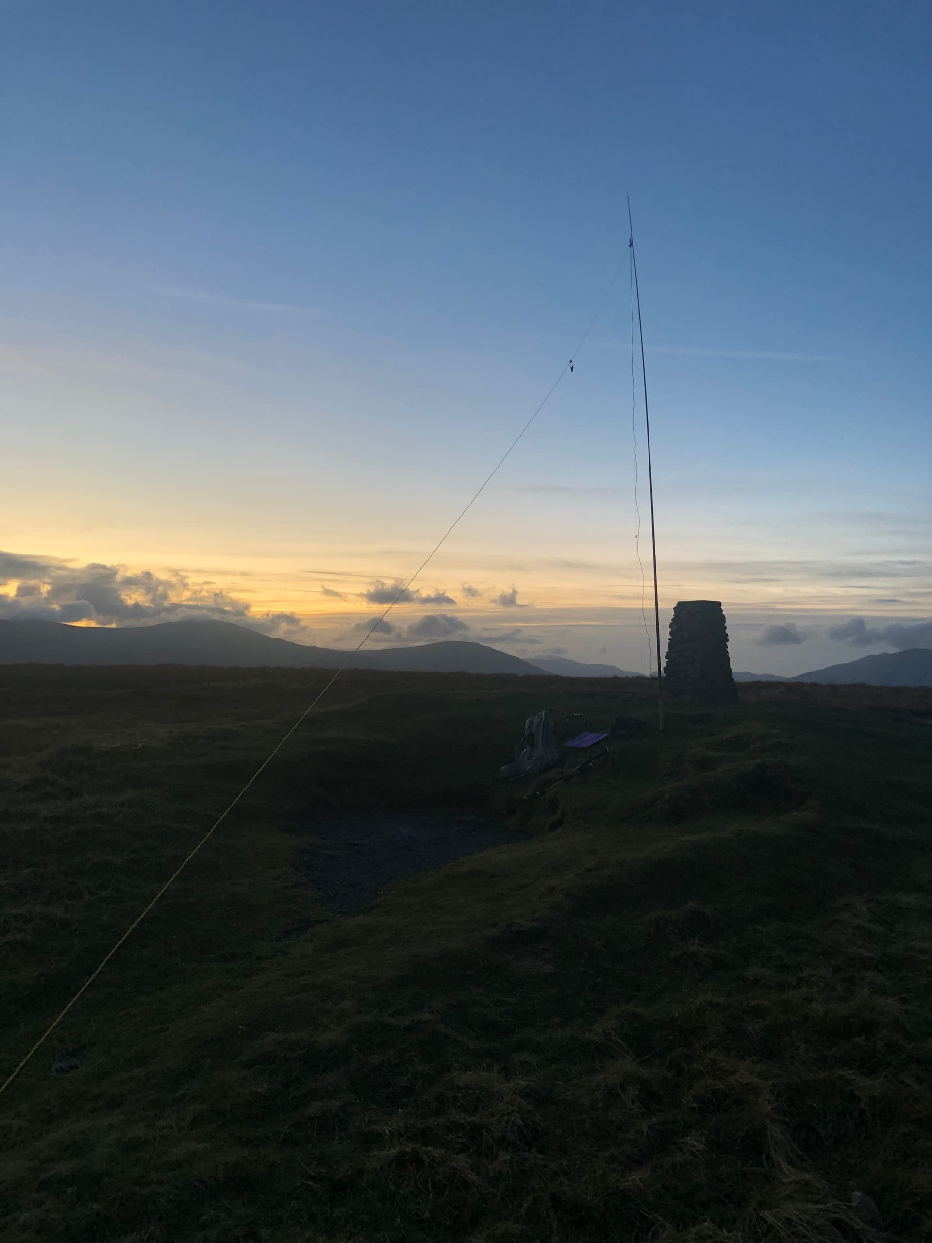
I was pleased to find that the bridleway consisted of a good enough surface to rid on my touring bike (32mm slick tyres), the bridleway took me to a path junction at SD777874 where a rough grassy patch was to be my camping spot for the night. It was now about 1730 GMT, and I quickly changed into walking boots to being the short climb up to the summit of Great Knoutberry Hill (G/NP-015). Under torchlite I made the boggy climb up the slope, keeping the wire fence always in sight to my left as a useful guiderail.
The distinct summit trig point came into view and I setup to call on 2m using my handheld, and RH770 antenna. It was 18009 GMT when I called CQ from a cold, foggy and dark summit. Nobody responded to my call, so after a couple of tries I setup the flowerpot antenna on my telescopic pole. The calls then started, with M7MCG, M1DHA and G7SXR follows by G8WT, G0PMJ, G6XBf and M7EGG. At about 1830 I went QRT and was glad to begin the descent. The strong breeze rapidly died away as a I lot height, taking care not to slip on the wet ground.

The summit of Great Knoutberry Hill (G/NP-015)
The reflective patches on my panniers came into view in the torchlight, signalling that I was back at the bike where I rapidly setup my tent, and began cooking a meal.

Dinner time
I managed a good night’s sleep, and woke several times to find I was too warm – I had the shed a couple of layers. The main issue with the 3-season tent is that it is single walled, and pitches with a gap of almost 30cm between the ground and the canvas – allowing a cold breeze to flow through the tent. It is great for avoiding condensation, but can make it hard to maintain the inside of the tent at a consistent temperature. The tent can be pitched closer to the ground, but is not designed to properly allow and leaves the fabric sagging and flapping in the wind.
Sarturday 3 December 2022

Camping above Dentdale

Riding back along the Old Coal Road
After a lie-in until 0800 GMT - to allow some rain showers to pass by – I packed away my tent and began the ride back along the bridleway. It was good to cycle back along the old coal road, and see the views that I missed in the darkness of the previous evening. I now joined the B6259 to head down the Mallerstang Valley stopping at Hazelgill Farm for my first summit of the day.
Back in walking boots, I was off walking by about 1000GMT, pausing under the railway bridge to change from cycle shorts to walking underwear. The climb was much easier than expected, with a good clear track, and firm conditions underfoot for most of the way I was soon turning south towards the summit, and admiring the views back down into the valley, and southwards towards the vale of Eden. The broad summit plateau is all with the activation zone, but I headed across to the trig point where a circular shelter gives good respite from the wind.

View along Mallerstang towards Kirkby Stephen rom Wild Boar Fell
On the walk across the plateau I had a QSO with G5AIB/P on G/LD-021 (Robinson). At the trig point I setup my flowerpot antenna on a 7m pole and called CQ at 1140GMT. First to respond was 2E0LLB followed by M0MOL, G0PMJ and G6XBF. I made a good number of contacts from the summit, and eventually left just after midday, knowing I had a decent length cycle ride ahead of me for the rest of the afternoon.

Wild Boar Fell summit
Changing back into cycling wear under the railway bridge, I was ready for the trip across to Penrith. The bicyle was reloaded, and I glided down the valley, pausing at Pendragon castle for a quick photo. The Co-op in Kirkby Stephen provided some fluids and sugar for the next part of the trek.
I cycled up the B6259 to Warcop where I joined the A66, passing by Appleby and Kirby Thore with Dufton Pike and Cross Fell tempting me to the right. I had ridden up to Cross Fell last year, with summer weight equipment, and didn’t fancy it with my current load.
The going was good on the A66 – I enjoy cycling distances on A roads, as they usually have good tarmac and smooth gradients. At Penrith I detoured into the town centre to get some warm food – it was 1600 hrs when I stopped. I noted that M0RWX was on Little Mell Fell at about this time, and I was hopeful I might somehow cross routes at some point.

Pendragon Castle

Warcop

Easy miles on the A66

Refuelling at Rheged services
After eating I was back on the A66, with a pause at Rheged services for water – I didn’t fancy in drinking from streams in the area around the Mell Fells.
I turned off the A66 too early, turning left at the Greystoke crossroads – with hindsight it would have been better to turn at the B5288. I spent a considerable time navigating winding backroads in the darkness, with many steep gradients. Passing Cove camping site (NY430235) I was prepared to throw-in-the-towel for the day, but found the entrance to the camping field to be padlocked, so I continued up the steep road the back of Little Mell Fell.
At the bottom of the hill I earmarked a patch of muddy grass on which to stake my tent, and then headed up the hill. I was delighted to find this to be the easiest 2-pont hill I have attempted yet – great news for the end of a long day.
Atop the summit l the lights of Penrith greeted me, and a hopefully called CQ at 1900 GMT. G0PMJ was first to respond followed by M0TRI and M7KAZ I was then hugely pleased to hear 2E0IKM calling me clearly – but we failed to complete the QSO for some reason.
There followed around 30mins of calling CQ, during which time I sat in my bothy back next to the telescopic pole on which my antenna was mounted. I was preparing to setup for HF operation, but didn’t really fancy it – the wind was starting to pick-up and carrying with it the occasional flurry of snow. The ground was beginning to freeze, with ice creeping across the surface of nearby pools of water. Eventfully at about 1930 I made a weak contact with G6XBF – this was thanks to G0PMJ asking some of his friends to try calling me (I could also hear M0WRi but was unable to work him).
I was glad to have had my bothy bag with me – I don’t think I could have spent 40mins at the summit without some form of shelter. Pleased that I had qualified the hill I scampered back down at about 1940GMT and began setting up my tent. Having already eaten a warm meal that evening there was no need to cook, I was straight to bed.

Little Mell Fell Summit (in the dark - the trig point is just visible)
Sunday 4 December 2022

Camping at Little Mell Fell

Back on the summit - same view as the night before
Given that Little Mel Fell was such an easy climb, I decided to head up to the top again after I had unpitched my tent. So at 0900 GMT I found myself calling CQ again – but with no contacts forthcoming. I was glad I had shown persistence on the previous evening; equally, I was glad to have come to the summit again so that I culd see it in daylight.
Back down on the bike, I headed across to Great Mell Fell (G/LD-035) – a very short ride. The walk up to the cummit was very muddy at first, and then passed though a copse of stunted trees before emerging ona round grassy summit. A dusting of snow on the ground, and patches of frozen water confirmed the previous night as having been quite cold.
Atop the summit I setup for HF with a linked dipole (set to 40m) and sat inside my bothy bag to activate. I was using a Venus SW3B (powered by a USB powerbank and DC-DC converter) and BaMaKey TPII paddles. I made a good number of contacts- ON7DQ was first, followed by GI0AZA, ON3UA and DL1FU. After completing HF I moved onto 2m and caught GM4WHA/M followed by 2E0MIX, G0TDM and M1LSD.
It was about 1120GMT when I left the summit, jogging back to my bike. I had considered activating Lords Seat on the way home, but since I wanted to be back for dinner I thought it best to head straight back and save Lords Seat for another day.

HF on Great Mell Fell

Cosy in my bothy bag
I joined the A66 – noting this route back to the main road as much easier than the one I had chosen last night. And began cycling with a slight head wind. Turning off the A66 at Braithwaite, I stocked-up on Lucazade ready for the climb over Winlatter and down into the Vale of Eden. I know followed the CTC route through the Vale of Lorton, and alongside Loweswater – passing many SOTA summits on the way. The las big hill of the day – Fangs Brow – was soon upon me, but a slow steady pace saw me crest the top and head into West Cumbria.
I made it home just as the sun was setting, and with time for a hot bath before dinner.

Ascending Winlatter

View from Vale of Lorton into Crumnoci/Buttermere valley - Grasmoor at left, Melbreak at right, High Stile in cloud in the background