Just accessing the webpage (before even logging on) I get the following pop-up message:
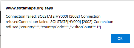
This is followed by:

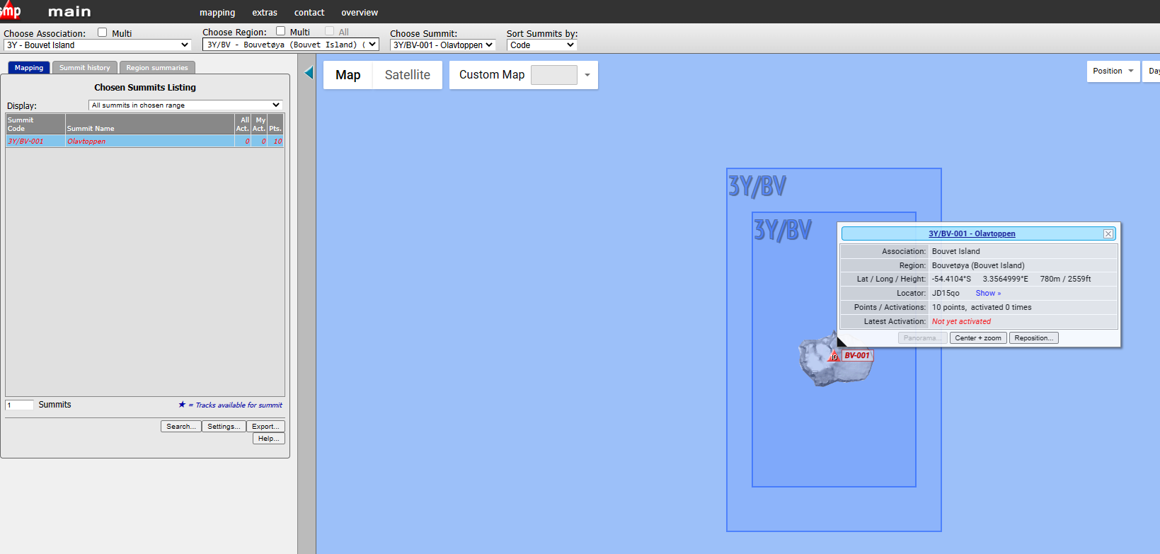
Although the world map then loads nothing is selectable from the Association pull down list:

73 Ed.
Just accessing the webpage (before even logging on) I get the following pop-up message:
This is followed by:
Although the world map then loads nothing is selectable from the Association pull down list:
73 Ed.
Same problem here Ed, not that I need to use it at present.
73 Phil
The same problem here. other map choices are working , but not Sota Map.
Same here …
@DD5LP you should send a report to the MT here:
https://www.sota.org.uk/Contact
73 Martin, OE5REO
Hi Martin,
Now that others have confirmed, it is not just my browser being awkward - report lodged
I rather like the message “Ouch” - someone has a sense of humour!
73 Ed.
Should be fixed now. The SMP database decided it wanted to restart and failed in the process.
You’re obviously not feeding it enough gummi-bears!
Thanks Andrew - confirming all looks fine now - thanks.
Now to plan that next activation …
(joking on the choice of Bouvet!).
Don’t forget that there will - hopefully - very shortly be an expedition to Bouvet Is. :
Still at least 3-4 days transit time. Then a massive job offloading masses of gear in dinghys on to terra firma. quite a risky undertaking, so fingers crossed for the crew.
Actually, DX-World News is giving some very good coverage (I have no association with DX-World, this is just my personal opinion of the clarity and regularity of their updates):
3Y0J – Bouvet Island | DX-World
If they land (hopefully in about 4 days) - I wouldn’t even try to get a contact for a week or 10 days as the super-stations will be hogging the contacts.
By the way, the Polish-led 3-Y-ZERO-Eye DXpedition which, like the US-led 3Y0Z one, failed before even getting onto the island because of ship problems, was planning to activate the SOTA summit. This (3Y0J) team’s planned location, unfortunately, is not suitable to get up to the summit from (even if they had time).
Fingers crossed - that all get safely onto and off Bouvet this time.
73 Ed.
P.S. from the latest DX-World report it appears the Garmin tracker is off-air at the moment.
Yes - 3Y0J will be setting up base on Cape Fie at the south-east edge of the island, on the only part of the island regularly free of snow and ice. I’m guessing they have little in the way of equipment for glacier crossing, and it’s nearly 6 kilometers to the summit of Olavtoppen from there. So, no SOTA operations from Bouvet this time around.
The Polish expedition would have setup on the glacier itself, at roughly the 2 or 3 o’clock position on the roughly round island, so would have been much closer to the summit. Plus, they might have made use of their helicopter(?) to get close to the summit…
It’ll be a tough boat landing onto a sloping beach with big elephant seals, and then an ascent through the rocks to the cape plateau this time around - fingers crossed for a safe setup!
Nice photo from the ISS, taken from the northeast, with Cape Fie at the extreme left-hand of the island as viewed here:

Not a McDonald’s in sight!
Just the occasional cruise ship full of wealthy old folk perhaps off shore…
Hi Rob,
It was the US team 3Y0Z who had the helicopters. The Polish team, (3Y0I) which as you say, intended to set up on the bottom of the glacier just had dingies to go ashore from the Atlantic Tuna.
But definitely no SOTA activation from this Norwegian-Led team - they are in the wrong place for it being practical.
73 Ed.
Fingers crossed for all the guys on the 3Y0J that they get there safely nd return without injuries or any other disasters - that part of the world is far from friendly!
This is turning into a Bouvet Island thread - but most threads on this reflector change subject at least once! (I’ve updated the title)
So for those of you want to follow the Marama Yacht and the 3Y0J team on their way to Bouvet - the Garmin tracker has stopped working (it was not a low battery as previously thought rather it has never been tried in these waters!) HOWEVER - good old ham radio APRS IS still working - the ID is “3Y0J TEAM” not just 3Y0J, which someone has used to mark the expected location on the island. here’s a link to track the correct APRS spots (received via the ISS):
The latest update is that they hope to arrive at Bouvet just before dusk on Monday 30th and the following two days are forecast to have calm seas to allow the unloading of the equipment using their two rubber dingies.
73 Ed.
Sometime ago I had a long chat with a guy from The British Antarctic Survey about their comms. They had leased 2x 64kbps (kilobits per sec) links on Inmarsat. These used small dishes and were available on ships with real time motion correction tracking or land based fixed links. 64kbps sounds slow but it gave them 24/7 voice and data. ISTR they were ditching HF as whilst the Inmarsat link was bandwidth restricted, satcoms was only going to get faster and cheaper and was the way to go. What was amusing was because they had the link that was paid for, they simply put Halley Base as an extension on the HQ phone system. You could be sat in the HQ offices (Cambridge?) and dial ext 12345 and someone in Halley would pick up the phone. He demonstrated this by calling HQ on his mobile and then dialling the Halley extension and let me talk to his colleague 14800km away. There was some latency as it went via a geostationary satellite. Cool stuff!
The discussion with the guy in Halley was Iridium was not all it was cracked up to be when you got to seriously remote parts of the world. The Iridium sats knew where they were and knew how much traffic there would be. The result was the sats shutdown a huge amount of their capabilities when travelling over the Southern Oceans and Antarctic as there were few ships and few possible users. Given the sats were in eclipse for a while and running on batteries for some part of their orbit, reducing the load. He said it was often not possible to make calls as all the (reduced) Iridium capability was in use and you would have to wait some time to get a call through.
That was 13 or so years back and the entire Iridium sat fleet has been updated and modernised. User base has grown and so has traffic capacity but it’s possible some kind of capacity reduction still takes place where there are few users.
The high-bandwidth datalink system the group have with them from Elon Musk’s Starlink service worked brilliantly on the Falkland Islands however stopped working about a day’s sail away from there. Whether it will work from Bouvet remains to be seen.
Their ICOM SatPhone (I presume using Inmarsat) continues to work.
73 Ed.
I didn’t even realise there was a Starlink Maritime service! I had a look and they’re in the coverage area marked as “starting Q4 2022”. But most of us have learned not to take anything Pedo Guy says at face value. Probably again a reduction in capacity as there’s “nothing there” frame of mind.
SpaceX does have at least 10 of their Starlink satellites in polar orbits, but I don’t know whether they’re fully - or at all - operational.