On the mapping site is it possible to navigate to an area of the map and say double click or use a right click menu option to get the map to select the group of summits surrounding the spot double clicked?
Eg, if I double click Garway Hill it would select G and WB group.
I would find that most useful, particularly on USA areas where I don’t know where W2 or W6 calls relate to.
Hi Steve - good question, and I had been thinking of something similar. I was working on a solution to this a few weeks ago, but had to drop it for a while. FYI there are no native click/doubleclick events in these particular maps layers, but it’s possible to hook something else into the layer to pass on the event. I’ll have a go this week to try to get this running.
Here is another feature which may be possible? As I used recently on the Mapy.cz website - where it is possible to drag a GPX file from a folder on your PC straight on to the displayed map and then see your track directly on the webpage.
I wasn’t sure if it was something else I had missed, or something I couldn’t get to work on the phone. Mapping is the weakest area of mobile browsing I would say (all mapping not the SOTA mapping) though a selection of browsers usually gets some success if there is no app.
Steve,
Not entirely sure that I understand your question.
Is this something different to the Range option which you can already use to display surrounding summits, based on geographical, locator, lat/lon or SOTA ref?
Pete
what I mean is I could browse the map (worldwide) find a spot, and quickly access the groups of summits on that area of the map.
EG. Other night I wanted to see if Mission Peak out side Freemont, Ca was a SOTA summit or not.
It was easy to find the summit on the map (as I have been up it) but took me ages and much clicking and zooming back to discover it isn’t.
If I could just on the summit and get the map to pop up the rectangle for the group the summit is in it would be cool.
Hence in my example, double clicking (or method) on garway would pop up the WB summits and enclosing rectangle.
that is quite good actually. takes a bit more input than my suggestion but is useful.
testing it I tried a couple of places and surprised how many unactivated summits there are in areas I have been to.
Gran Canara has 27 summits and only one ever activated. I can see why it’s had 15 activations though. It’s a 10 pointer you can drive practically right to it, and even the “walk in” from nearest car park is 0.03 miles!
The really great feature of this is that in my Hereford example there are hills shown from four different SOTA regions in two associations all within the 50km circle.
73,
Rod
It is now possible - not with a double-click, however (double-click in Google maps is usually reserved for zooming). Here’s how:
in the range page, click the “Define range” button at the top left;
in the “Define range…” window that opens, choose range type and dimensions as usual;
choose “Select point on map” from the “Reference point type” dropdown;
zoom into the area where you wish to mark your reference point;
click on the “Pointer” checkbox: this will change the mouse-pointer to a crosshairs when the mouse is over the map, showing you that you can mark a point (the mouse can still be used to move the map around as usual);
click in the map to place a marker at the desired point:
this marker can be dragged to it’s final resting place, or
click elsewhere in the map to move the marker to a new point;
when you’re sure the reference-point marker is where you want it to be, click on the “Map »” button;
if any summits within range are found, they will be shown as usual;
having clicked on the Map button, the “Pointer” checkbox will be un-checked and the map mouse cursor will be returned to it’s default.
Reactivating the “Pointer” checkbox and then clicking on the map will clear all results and you can choose another point.
Hope that comes somewhere near what you were looking for Steve.
I had never realised this could be done. After reading your post and explanations, I’ve tried it and found it fantastic!
Thank you very much, Rob.
Let me point out a possible feature to be added to this great tool.
What about adding a way to highlight either:
those summits which have not been activated in the current year
those summits which have never been activated by the ham making the query.
those summit which have never been chased by the ham making the query.
those summits which are completes for the ham making the query
This would apply only to the summits displayed in the specific selected range.
Of course this would require that the mapping tool be connected with the database and the ham querying this be properly identified.
Just an idea…
Best 73 de Guru
…and there you have it. I’ve been pleading for access to the database, for nearly two years, and I’m still waiting. Those points you mentioned could all be implemented in the SMP in just a couple of days - WITH the data.
[quote=“EA2IF, post:14, topic:11699”]
I had never realised this could be done
[/quote]But you knew about the range page, right?
I should because it’s probably been there for long but I didn’t.
Honestly, I’m not the typical curious guy clicking on everything and trying to find all features and possibilities in a given program or application.
Now, thanks to your post, I felt interested to see that and I clicked on “range” for the first time.
I have used tracks sometimes but have never clicked so far on any of the other tabs: alerts, spots, extras, contact.
I haven’t felt the need for it yet.
OK about your request for access to the database to which OK you are still waiting for.
Let’s see what happens…
Best 73 de Guru
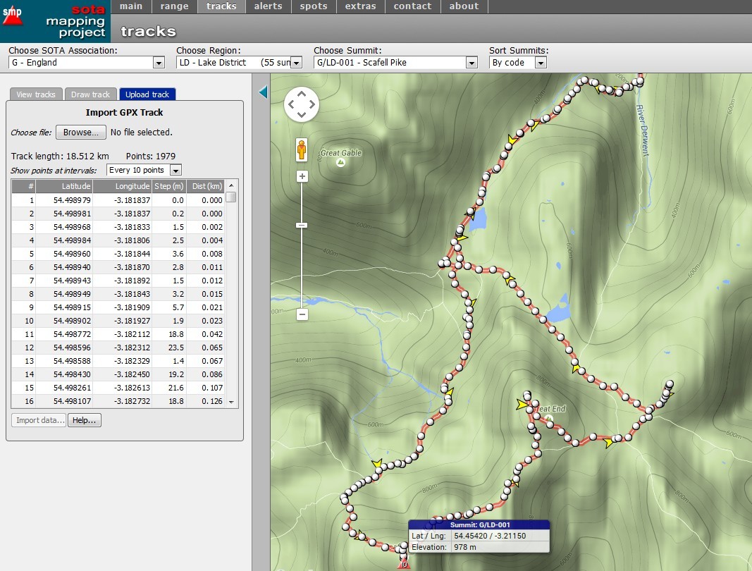
Hi Phil - this has now been implemented in the tracks page. I’ve tried it with a number of different GPX files, and the code likes standard GPX files, but is having some problems with files containing non-GPX-standard tags. But it’s a start - try it and see what you think.
Update - the drag-and-drop code now accepts any well-formed GPX file, regardless of whether it contains any proprietary, non-standard tags (things like “<topografix:width>940</topografix:width>”), so that little issue is solved.
Be interesting to know whether anybody has tried the drag-and drop option in the tracks page yet?
These are not my words but describe XML just perfectly.
“Some languages can be read by human, but not by machines, while others can be read by machines but not by humans. XML solves this problem by being readable to neither.”
This is a screenshot of a dragged and dropped GPX file collected on a recent activation I did of Scafell Pike. I first tried a GPX file collected using Viewranger in OSM on my phone and that displayed for saving. I then tried a GPX file collected on a Garmin GPS62s and that worked also.