The Tracker shows you the bearing, distance, and elevation to your destination, and as you approach the summit’s 25m vertical activation zone, it will highlight blue, and then finally green when you’re there.
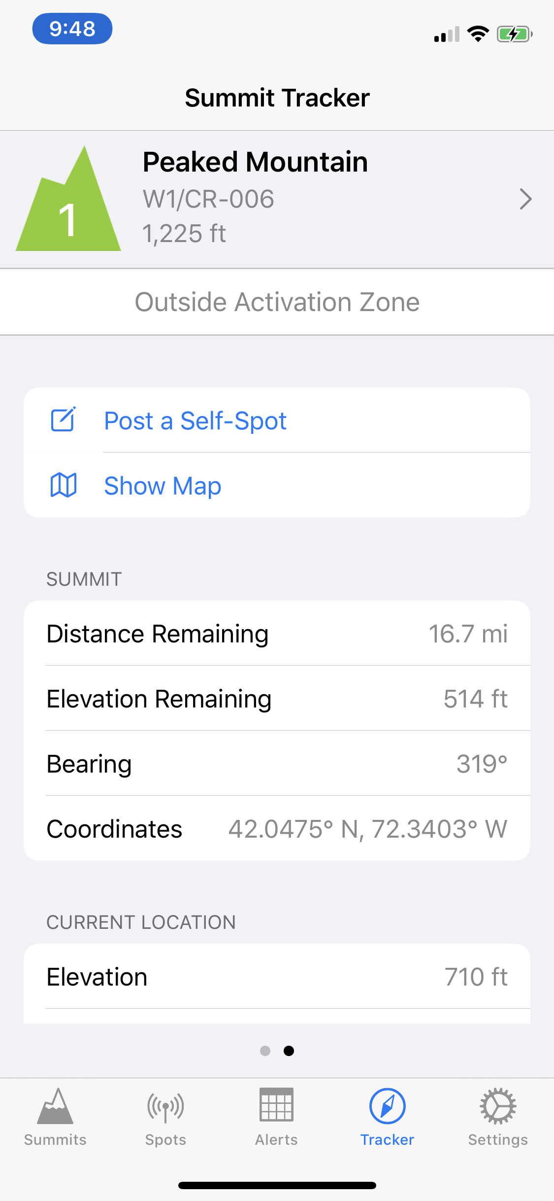
The second page shows more location details, as well as quick links to post a self-spot or show a map.
Speaking of self-spots – the setting to customize your callsign has returned.
Reviews Requested
I have chosen to reset the app’s rating in the store with this release. The poor reviews that were impacting its score did not accurately reflect the new reality of the app.
I would welcome and encourage all users to please leave a rating. You don’t need to write a review - just tap a star rating. I’d really appreciate it.
Thanks for all the up dates. I tried searching in App store on my android phone but it does’nt show up after a search. Is this app for I phones only .
vk5cz …
Being at or above summit elevation - 25m is a necessary but not sufficient condition for being in the AZ. Also bear in mind the inaccuracies of phone elevation data, and even in some cases the mapping data used for summit elevation. So be cautious. Nice feature to have none the less.
If your elevation is within 25m and you are within a 1km radius, you are in the AZ.
If your elevation is within 100m and you are within a 2km radius, or you are at any elevation within a 500m radius, you are “near” the AZ.
Otherwise, you are nowhere near the AZ.
It is obviously not meant to be a definitive source. I would hope activators have common sense to avoid dangerous situations just for the sake of an imaginary circle. It’s the spirit of the activation that counts, right?
That’s probably not a bad guess, although not infallible. For sure there are cases where the AZ extends beyond 1km, and also many cases where an invalid subsidiary summit is within the required elevation range and less than a km away.
Indeed, activators are responsible for acting safely. But following SOTA rules means that the operating position must be in the AZ. It’s tough when this isn’t possible whilst staying safe, but you’ve got to be prepared to chalk it up as a failed activation. I hope everyone is familiar with the exact definition of the AZ. See the General Rules (see 3.5.6).
Rockwell,
Thanks for another amazing update. You are reading my mind on how I use sotagoat. The new features will save me a few steps when finding the nearby summits and knowing if I am in/near the activation zone. Really great updates. SOTA wouldn’t be the same without SotaGoat for me! I left a 5-star review in the app store.
73, Jim
I would use that facility with caution. The height accuracy of the GPS system is significantly poorer than the horizontal accuracy and errors can easily be in the range of 10 - 20 metres.
I’m genuinely curious to see if this is problematic, in practice. If so, I can add a readout of the vertical and horizontal accuracy, or just remove the AZ feature altogether.
When I go on a SOTA activation, I always hike up until I reach the very summit, marked by either a trig point, mountaneering mailbox, just a cairn or by simply being the very highest point within the summit GPS coordinates. However, I’ve sometimes needed to move away from the very summit and the way I’ve used to know if I still was inside the AZ was by setting to zero the relative height measured by my CASIO wristwatch altimeter while at the very summit and then hiking down while reading that relative height measurement. As long as I read less than 25 (to be precise, more than -25), I know I’m in the AZ.
The altimeter of my CASIO watch is based on barometric pressure but the baromatric pressure variations in the time window between setting the relative measurement to zero and hiking 25m down is so small that I’m sure the reading remains accurate enough.
However, to be absolutely sure, it will always be safer setting up at -18 than at -25 with respect to the very summit.
73,
I consider this a potentially useful tool. I use paper maps, GAIA, the height shown by APRS on my HT, and summit features to make certain I am in the AZ. The AZ tool looks like it will be useful and I would like you to keep it as a part of the GOAT - until we have a chance to work with this in the field we can not properly evaluate and for many of us it may be quite a while before we have time to properly evaluate usefulness. One of our local popular SOTA summits is Mount Tamalpais - there are three summits and the summit that looks right visually is not the designated SOTA summit - this tool would certainly help distinguish the correct summit from the other two.
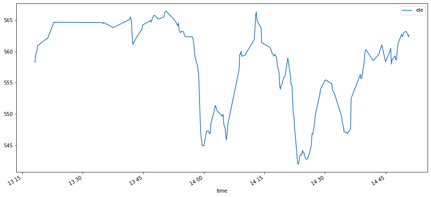
I looked at a recent GPX recorded on my phone. I usually pause recording to the GPX whilst doing the activation, so as not to leave a mess of track points at the summit, but this time I forgot. So here’s about an hour and a half with my Moto E4 sat in the same spot, right next to a summit trig point.
I’ve quoted the standard deviation there as an illustration of how much a phone gps can drift about. But I hadn’t anticipated the mean would be so far off (it’s low by 69m). I might wave my hands and say it’s an ellipsoidal vs. geoidal height thing, but I suspect it’s wrong in the wrong direction. Will have to look more closely at that. I think GPS will typically be quoting ellipsoidal height (I stand to be corrected), which mostly won’t be the same thing as a local mean sea level height.
The drifting about I suppose might be a lot less once we’re using Galileo. And of course a phone GPS is a poor cousin to dedicated units.
I gave the summit tracker feature a try today on HB/GR-269, and it seemed fairly accurate on my iPhone 11 Pro. It started telling me that I was in the AZ when probably about 5 (vertical) meters were missing according to the Swiss Topo map. Also, while ascending the final slope that leads to the summit, I saw the distance/elevation remaining readings decrease smoothly and steadily At the summit, it told me that the elevation remaining was -5 meters.
But I agree that GPS altitude measurements are highly variable and often inaccurate, and in any case to determine whether one is really inside the AZ would require accurate DEM data. So perhaps instead of telling people that they are “Inside Activation Zone” even though they might technically not be, would it not be safer to simply tell people that they are “Near the summit” (e.g. if within a 50 m radius)?
 New Features
 Bug Fixes
 The Summit Tracker
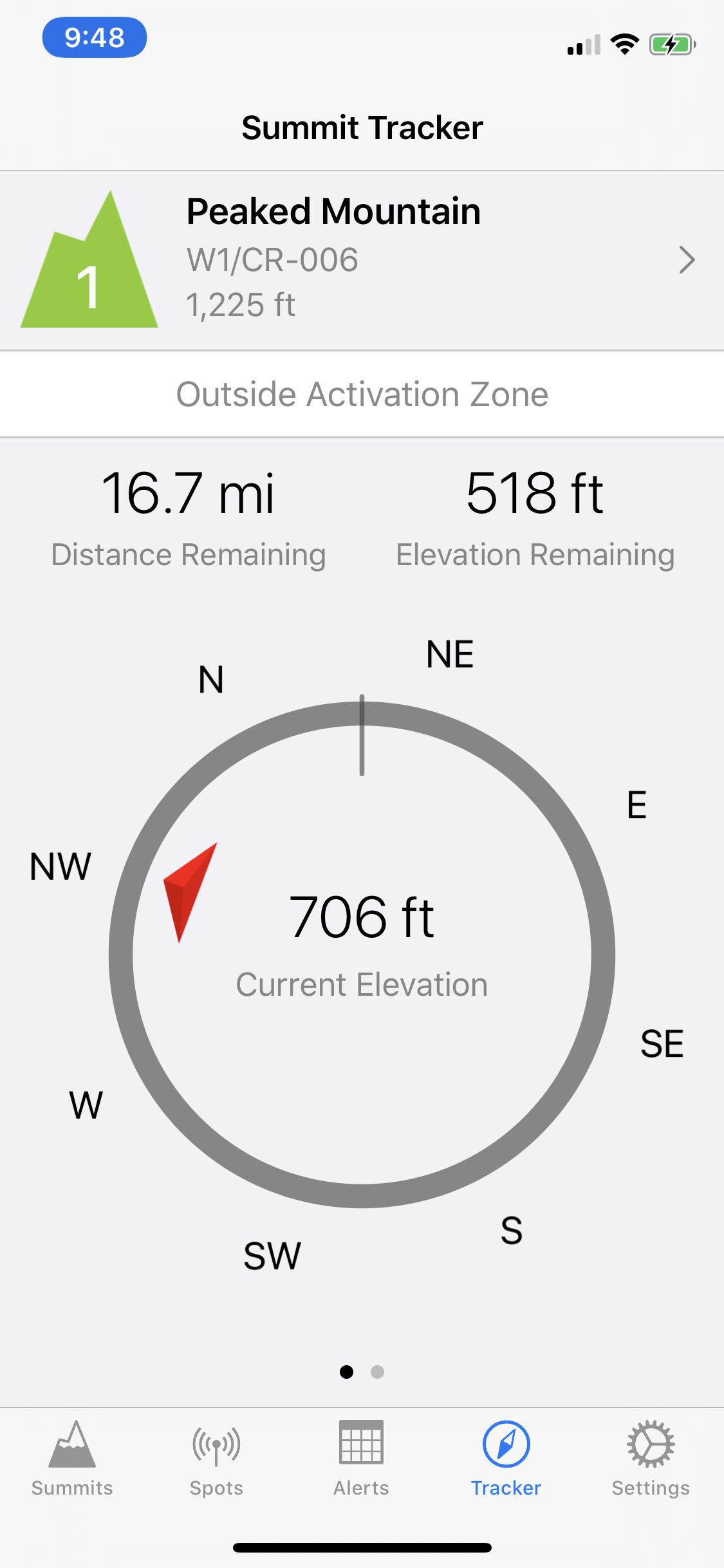
 Reviews Requested
 At the summit, it told me that the elevation remaining was -5 meters.