I am absolutely not an expert in this, but I think:
Single band
No differential correction
GNSS accuracy is itself improving (better clocks so the satellite TX is more accurate) which will surely improve even consumer device accuracy. But ultimately you’ve got to do something to cancel out the effect of the ionosphere. I doubt RX noise is that much of an issue as these things are pretty bright (too bright, speaking as an astronomer!!) when they are line-of-sight.
It’s an effect but you can “average” the effect if your sats are well dispersed.
The basic commercial GPS chip rate is 1MHz and we’ll assume speed of radio wave is 300000000m/s. This gives basic accuracy of 300m if GPS only uses whole chip. Remember all sats are sending a pseudo random stream 1024bits long. The sat tells you where it is and the chip number. You had to slide your local chip number backwards / forwards to gain sync with the data you receive. So if your GPS chip counter is at 500 and the sat says this is chip 100, the signal is 400 chips old or it left the satellite 400chips ago or the satellite is 400 x 300m from you, or 120km. If you have 3 sats telling you where they are in space and you know you are “on the Earth” then you can solve for where you must be to be 120km from sat 1, 970km from sat 2 and 500km from sat 3 for example and there’s only 1 place on the Earth that meets that requirement. By taking data from more sats you can guestimate the error in your local counter as for you to be in sync with 8 sats they wont all be whole numbers of chips away. i.e. you can work out a greater resolution by iteratively calculating sub chip offsets and you can use that to discipline a higher frequency local oscillator and measure finer resolution.
So 1MHz gives 300m resolution. If you run your chip rate at 10MHz you can get not 1us resolution to the sat but 100ns resolution or 30m. But you need a stable clock that doesn’t jitter as 10ns of jitter is 3m resolution. So you need to discipline your local clock so you know how much it drifts etc. and then you can measure arrivals more accurately.
The military code chip rate is 10MHz so it is 10x more accurate to start with. The chip pseudo random code is secret and longer than commercial code. So it is nigh on impossible to brute force it. (Probably can be done now if you must but cheaper to steal a military GPS!)
So location accuracy is all to do with how accurately you can measure arrive time of chip and offset of chip from 1us boundary. Leica box just has much more accurate and stable clocks (physical and temperature isolation) and its software does hours and hours of average/measuring.
If speed of propagation changes then 1chip = 300ms is no longer true which is why changes in propagation affect accuracy. EGNOS and WAAS and DGPS use a fixed location and measures its GPS position to work out how innaccurate the timing is and correct for propagation changes. These can be sent to GPS receiver so it knows 1chip= 299.8272627262ms etc.
And you buy a receiver that does all this with integrated 1.5GHz antenna that outputs position info accurate to <10m or 1pulse per sec timing accurate to pS etc. for £5. And, unlike original receivers which had to match entire code space using 1 correlator and could take 5-7hrs to scan the whole spread spectrum space to gain sync, it will have 256000 (or more) correlators and can do a cold fix in less than 60secs.
EDIT chip rate is 1.023MHz so whole cycle takes 1ms. But the above is accurate enough as a top level overview.
I fully agree that GPS altitude measurements from a smartphone are not to be trusted, at least not for determining AZ extents. But the pressure sensors seem to be more accurate for (relative) altitude measurements. The one in my iPhone can reliably tell the difference between the phone lying on the table, or on the floor less than 1 metre below. I find that quite impressive. Of course, how much natural pressure and temperature variations on/around a summit affect the result is to be determined.
Unfortunately the simplistic model that it uses (for lack of worldwide high resolution DEM data) means it should probably rather say “maybe inside AZ”…
Andy,
I’m not sure your analysis is completely correct. GPS measurement does not require a locked local clock. I might have misunderstood you here. The box is making repeated relative measurements so resolution trumps long term stability. Resolution is increased by averaging.
Obviouslyy short term stability is important however the satellites have atomic clocks so they provide the stable reference. Local drift shows up as errors which can be averaged down by the software.
A rule of thumb is that vertical uncertainty is 3 times the horizontal uncertainty. Horizontal uncertainty is given on proper GPS as the diameter of a circle centred on the device. 3 m is very good in a consumer grade device.
Relative measurements can be made with a hand held GPS to maybe 2 to 3 m vertical. Your results may look better but if you repeat in a month you may be dissappointed.
Government maps have contour lines that are usually good to 70% of the spacing. In some well surveyed areas this can be better. So for 5 m contours they may have uncertainties of 3.5 m vertically.
For SOTA taking a government survey map at face value is the gold standard imo. The errors can be ignored for SOTA imo. Taking the average of multiple measurements up and down a hill with a GPS is good for finding the AZ but takes longer than studying a map.
Google Earth is an American consumer product. The flooding function works best on a smallish geographic area and is useful in locating the potential limits of the AZ. It’s altitude uncertainty varies from a few m to hundreds of m. It is badly affected by terrain with ridges.
1 m uncertainty wrt the world geoid is attainable only with survey grade DGPS or long term measurements with a survey instrument designed for that. (Repeatability is not accuracy.
A stable reading on your phone tells you nothing about bias errors. )
Self contained DGPS can be purchased for the price of a transceiver but the base line is limited by the range of the inbuilt Bluetooth link. It is good to mm but not practical for AZ measurement.
In spite of all that I still use my mobile phone and SOTLAS to compare with what the MK 1 eyeball says.
That seems not unreasonable for contours from photogrammetric sources. However, as mapping agencies move to LIDAR they gain an order-of-magnitude improvement in accuracy. I don’t suppose they will start to crowd out the maps with many more contours.
Its provenance is closely guarded, even internally I have been told. Probably some areas are a lot better than others, but assume the worst.
As I alluded to up thread there has been DIYer work on DGPS. This could be a very interesting project, I suspect, for anybody with the time. Here are a couple from my bookmarks (no doubt there will be others):
By the way there’s a good lecture series on GNSS techniques on YouTube, which will explain Andy’s chips and suchlike. I think it was Stanford.
Thanks. If Andy was designing these chips then I’ve misunderstood some of his post. Apologies.
I’m not sure about LIDAR being 10 times better. Having a human see the raw data helps remove errors such as a cow where it should not be. The Shuttle Slant LIDAR is horrible if the peak has a sharpish ridge.
Maps of the Moon may be better than Earthly ones. No vegetation.
I meant the “chip” timing intervals he was referring to! Not his silicon, so far as I know(?)
Both cows and vegetation have a different spectral response and should be excluded from LIDAR-generated DEMs. Removal of built structures is maybe more of an issue, as the software has to infer that from shape, with certain tuning parameters.
Edit: Of course you want to leave the buildings in for air navigation purposes!
Not worked on GPS chips. A long time ago 2000/1 vintage, I was working on a Bluetooth chip working at the L1 level. We dynamically enabled/disabled digital RX components as the bit stream was clocked past, i.e. you see the incoming packet is SCO after only a few bits of data are rx’d so you can then enable the audio side of the chip for this packet and on the next packet you would see it was ACL data so you could power down the audio part. Useful to save lots of power on battery stuff. This power up/down is done at tens of kHz rate
We had a home rolled microcontroller to do this which looked and smelt like PIC1684 type architecture but it was 16bit accumulator not 8bit. My only dealings with GPS customers was when the team specifying that project were talking to us about using our micro and the tools we had. At the time the only assembler we had was written using the VHDL TextIO package (this happens when digital engineers try to write software) and it took 25mins to assemble the code on a SOTA Sun SPARC workstation (state of the art!). I was pleased to be paid to sit on my bum for 25mins at a time but after 4months taught myself enough Java to write my own stand alone assembler for the micro. It took just under 3mins to do the same job running on the Sun. When we got some decent PIII 700 Windows NT (gosh it was that long ago) machines, the assember worked as is on Windows. One of the few nice things about Java! I gave the assembler to my employers at the time and as a thank you I got to go to Bluetooth UnplugFest V in LA, April 2001. 6 of us were able to fix a bug in our microcode whilst at the event which stopped encrypted packets working. The thank you there for spending all day in the event and all night working on bug was that we were treated to a slap up meal at a posh restaurant in downtown LA which IIRC cost just $1k (2001 dollars) for the 6 of us and we weren’t drinking expensive wine!
Not in the sense you are thinking off such as a GPS disciplined 10MHz reference. The GPS receiver clock has to be very immune to jitter and short term drift or your position on Earth will appear to jump about. Especially as most domestic GPS receivers are designed to save power by gaining sync, determining a position and then going to sleep for seconds/minutes if you don’t appear to be moving. When it wakes up drift and jitter will make your position appear to move. The Lieca units have local clocks with very well defined short term drift and jitter, they don’t sleep and do continuously gather data and do “averaging” on the readings.
In respect of drift vs. “absolute” time that’s why you need at least 4 satellite rather than just 3 isn’t it?
By the way I’m not entirely convinced about the averaging yet because there can surely be consistent gradients of electron density (with respect to the magnetic pole and zenith). Wouldn’t you expect that under those conditions your carefully averaged position would be pretty consistently wrong? Wouldn’t like to guess how wrong though. I would presume that surveyors would therefore keep an eye on the “space weather”.
Actually I’ve got to talk to one for work imminently, so I’ll try to remember to ask.
I’m not good enough a physicist to really understand the issues but there can relativistic effects in the atomic clocks as the sats move at high speed relative to the Earth such that the clocks in the sats need resetting because they have moved. I’m not sure how often they reset them.
You are correct in that it’s not just averaging but some kind of advanced maths magic but the term “averaging” is good enough. Analogous to the concept of atoms are made from electrons, protons and neutrons when we know there is a sub-atomic soup of particles. But for many purposes a simplistic description is good enough.
My venerable 2008 vintage GPS does fast acquisition and can use WAAS/EGNOS. to give ~3m precision. WAAS/EGNOS is a DGPS system where the correction information is uplinked to a few geostationary satellites for rebroadcast reception by commercial handsets. But as it comes from sats above the equator, the satellite is pretty low in the sky at my latitude (56N) meaning trees and buildings can obscure the view of the satellite making it not guaranteed that you can always receive the signal.
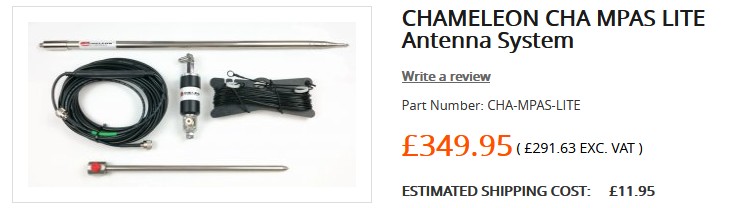
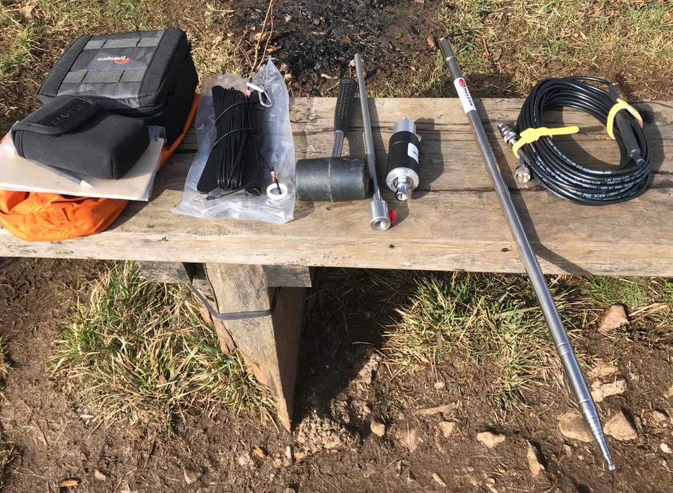
That’s the one Phil. Yes, it’s expensive but the built quality and ruggedness are impressive and I expect it to give trouble-free service for many years. There was a break in the heavy rain this afternoon so went to a open area overlooking the Kent Estuary / Irish sea to try it for about an hour. Had the vertical and counterpoise set up in a few minutes. The strong wind was blowing my notepad and stuff all over the place but the thick 17ft telescoping whip was swaying only gently.
Got some decent reports on 20m with 10W CW [Lithuania, Finland, Portugal]. Would have loved to have stayed longer but my recently-shorn little dog was shivering despite wearing a coat. Looking forward to some more field testing in time for SOTA restarting - next test is a A vs B comparison of the vertical with my 60/40/30/20 linked dipole.
Ahhh… 17 feet long whip Andy, not a lot of people know that (Quote - Michael Caine). I hadn’t realised it was that long Andy, no substitute for length. I think as long as its matched it should do OK on the summits where it’s needed. It will interest many of us when you get the results of your comparison. Thanks in advance for sharing the information.
Back to the topic. Amazing how the focus gets lost.
You can do interpolation between contour lines to get double the resolution and more. You need to examine the trends. If the lines are fairly evenly spaced it’s easy. I won’t give a lecture on it you’ll be pleased to know.
Indeed all maps use some interpolation and extrapolation, now done by software.
Boots on the ground with good equipment is still the most credible.
As far as I know there are no altitude police roaming the hills and issuing tickets for someone being 1 m outside the AZ when their GPS said they were 2 m inside. You do the best you can.
Some good info here on this thread on better devices.