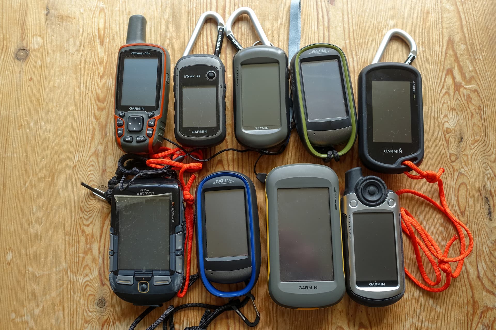
Using a Garmin Oregon 700 with Open Street Maps since about a year. Works very well. Always having some spare batteries with me.
… and Garmin Inreach Mini for emergency communication.
Do not use the same phone for communcation and for navigation. GPS will very fast drain your batteries.
Make sure if one device fails, it will have a limited impact on your ability to communicate and to navigate. Always have a plan B.
Love my GPSmap 62s it’s survived several years of abuse and still going strong
I print out route maps from OSmap at A4 and put them in a transparent A4 pocket, back to back with a copy of the day’s itinerary. Folded into four fits nicely in the pocket of my Paramo Cascada trousers. We’ve been out in some truly awful conditions (ask Gerald G4OIG ) and not had a problem with the map getting wet. When the paper log has been entered into the database pop it into the wallet with any other relevant info and the whole lot’s ready for filing away as a record/reminder of the activation(s)
Been using them for 20 plus years. They tear or discolour eventually - probably on number 5 now. I also keep a copy of the radio menu for reference on the hill.
73,
Rod
I’m on my second Ortlieb case and fourth case overall. First was a Millets own brand which soon failed (low flexibility when cold causing cracking). Then I had an Ortlieb which I left on the summit of Beneraird GM/SS-201. I used a Lowe Alpine one for a number of years, it’s more flexible than cheap cases but not as good as the Ortlieb and has started cracking. Then I found a cheap Ortlieb on eBay. So I have not had one long enough to see tear or discolour yet!
Garmin Family and end of the story!
Rarely but when is a new summit for me and it requieres long hiking in addition to the GPS unit I print a 1/25,000 map and I also carry a compass.
For years used a Garmin 450 until the power button became unreliable. About a year bought a Garmin 750T which is one of those wonderful touchscreen things. The inbuilt maps are only a guide, not the most detailed.
Has a camera which occassionally comes in handy.
Always carry spare batteries.
I’ll come in from left field. I use the SATMAP system. Expensive and you have to buy the map separate but it’s an excellent piece of kit. Touch screen but hard buttons to do the same. Wifi capable you can link it to your phone. It’s not light but really great.
Have used several GPS devices over the years all with OS Maps.
I find the dedicated GPS touch screens very unresponsive compared to a smart phone and all of them can lock on slowly. They also seem to suffer more under leave cover; at least that’s my experience.
Battery life can vary, but they take AA. Oregon 700 series battery life is extremely poor.
Page scrolling/page updates are also very very slow.
I now use an iPhone X in an Otterbox case with OS Maps app as my main SOTA SatNav (w/ PowerBank in backpack just in case) and carry the eTrex with spare AAs as backup (together w/ paper map & compass on longer hikes).
If I were picking one today (but I am not as v. happy with my iPhone X), I’d get a Garmin 66.
At the risk of being that cranky old “get-off-the-lawn” kinda guy and as a fossil who was sailing and mountaineering long before GPS, might I suggest that this groovy, new-fangled device has the potential to become more of a crutch than an an aid?
Nothing replaces a good sense of direction and basic, unaided route-finding skills. I humbly suggest that you young-uns start with a map and compass and hone your unaided map reading and route-finding and use the GPS only as a backup.
…and as you are going up, be sure to turn around occasionally and look down at your downward landmarks even if you have a GPS.
You never know when that valuable tool might fail and your own good sense of direction is all you have.
We now return you to the 21st Century. Thank you.
Eric KG6MZS
Who remembers the Loran.
PS; I have a mountaineering buddy that lives on remote road out west here that is littered with the bodies of lost souls. His bumper sticker reads: “Your GPS is Wrong.”
The question was which GPS and the answers have said why some think a GPS vs a phone is the right way. Peppered throughout are comments about knowing how to navigate with map and compass and how to navigate and not to rely on a single electronic device.
I use my GPS a lot but only after consulting the paper map and looking about and reading the contours with me feet. i.e. I try to know where I am most of the time and when I think I know where I am I confirm that on the GPS. The important point is to know how to cross-check map and GPS and to know how to recover should the GPS fail.
I’ve been not where I expected when in the mist a few times. Do I have an innate navigation skill like a homing pigeon? I don’t know but I’ve often not gone too far wrong before things didn’t feel right. I’ve tried to locate myself on maps before using the GPS (fences, ground etc.) I’ve been totally lost once. Well not so lost that I could not get to the car but more that I could not get to the summit in time for the uWave scheds setup. I had forgotten the paper map and the small GPS screen did not show enough detail. I could have followed the GPS blindly but my mind thought it was wrong for some reason. Madness, yes but the same complete disorientation has killed many pilots and until it happens to you then you wont understand what it feels like to see a GPS say turn left and you know it’s wrong and go straight on!
I always have my mobile phone with me. So, I install some navigation tools. They are very handy.
But, for the best results use specific tool for the job. Mobil phone is universal tool.
There is one feature I don t like about gps or mobile screen. I can see details or wide picture but not both at the same time. Paper map is esential. And compass too.
In the forrest or mountain one need to be “afraid” and always know where you are.
Me and I used it too . I can also remember doing Astro nav, though please don’t ask me to do it now!
I won’t contribute to the decision as to which particular GPS since others have submitted their views. However, I will comment on one aspect - additional capabilities. The 66 is getting a few votes with respect to its satellite communication capability. I think you should consider why you want that capability. If it is to retain the ability to communicate with others even when a standard mobile phone signal isn’t available then fine. OR is it purely for emergency use to alert the authorities when you’re in dire need? If it’s for the latter reason, then I suggest you consider a stand-alone PLB (personal locator beacon). They are generally small, light-weight, reliable and have a long battery life (years). They also do not require any airtime or service charges after the initial purchase.
Okay allow me to hijack this thread even further and ask: anybody read Longitude by Dava Sobel? Fascinating look at the time before we could reasonably fix our east/west position and the devastating consequences of dead reckoning (accent on the word “dead”). This book chronicles the race of two competing navigation systems to fix an observer’s longitude. Good read.
I use Gaia on my phone, but the Garmin 60 look interesting. Thanks all.
Is that the book where the science is weaved through a tale of the young author sailing across the Atlantic with their Uncle or Grand father from New York to England un the 1970’s? Wonderful book.
Another favourite of mine - The Great Arc by John Keay. How the Indian sub-continent was surveyed and mapped, leading to the first accurate height measurement of Mt. Everest.
Great book. Sorting out the problem of longitude determination was crucial for the settlement of and trade with Australia and New Zealand. I have recently visited Warrnambool where nearby lie many a wreck whose crew misjudged their position by a mile or two after sailing halfway around the world.
Sobel writes well and her book on Galileo is worth seeking out.
I read some comparisons of the various Garmin GPSMap versions (and some other ones) last year and it was interesting to see how they struggled with different situations, despite having fairly similar specs. If you want to use the inreach capability of the GPSMap 66i you need a separate subscription for that, but that can be bought on a month by month basis as and when you need it. That makes it much more appealing to me, as you only pay for it when you want it.
Just to make it more complicated I use a Suunto Ambit Peak - a watch with a GPS. (I needed a new watch so had an excuse). I have navigated with it but would probably not use it as my main navigation tool, but it is a handy backup - the combination of the ability to get a Grid reference and compass bearing is handy. So not a replacement for a GPS Smart Phone or map but a handy extra which is almost impossible for me to forget…. Although the feature that allows it to measure your ascent rate can be depressing…. Paul

 ) and not had a problem with the map getting wet. When the paper log has been entered into the database pop it into the wallet with any other relevant info and the whole lot’s ready for filing away as a record/reminder of the activation(s)