Prologue
©Crown copyright 2021 Ordnance Survey. Media 018/21
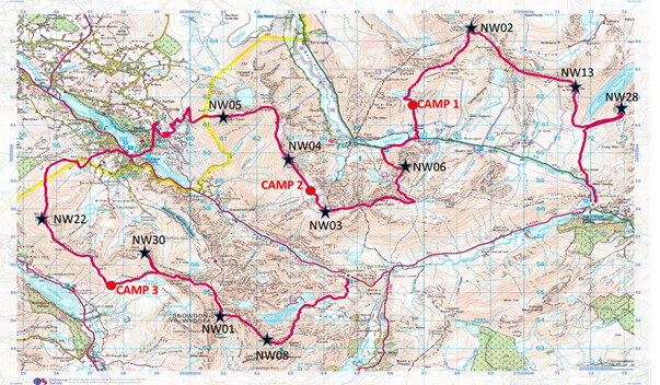
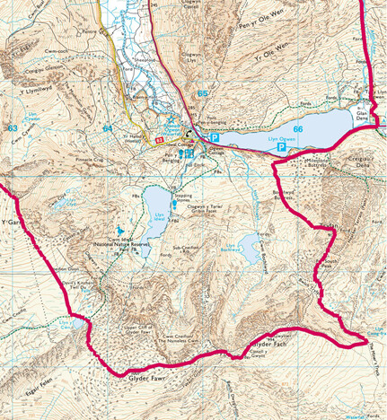
The route covers eleven SOTA summits, totalling 82 points. Distance is around 60km with 5000m of elevation gain.
All of my activations so far have been in The Lakes and North Pennines. Despite undertaking many long distance walk in England and Scotland, I have not been to Wales since I was a schoolboy. North Snowdonia offers plenty of options for a multiple SOTA summit trip and so I started hatching a plan centred around the 10 point summits.
The route above was the product of my planning, noting that a further summit (GW/NW-010) could also be attempted in order to close the round and finish back at Capel Curig.
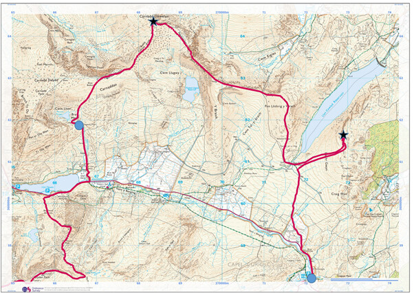
I set off after work on Wednesday 15 September 2021, boarding a train at around 1700hrs; a poor connection forced an overnight stop in Warrington (a Travelodge – camping in the park did not look attractive), and I eventually arrived in Capel Curig at about 1030hrs BST on Thursday 17 September (via Bangor). A surprisingly good bus service runs to Capel Curig.
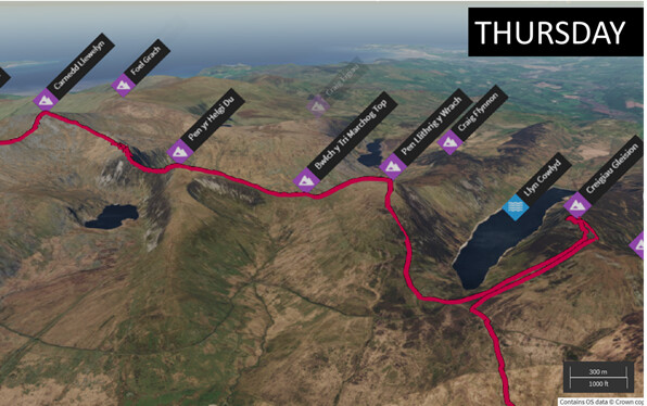
THURSDAY 16 SEPTEMBER 2021
©Crown copyright 2021 Ordnance Survey. Media 018/21
©Crown copyright 2021 Ordnance Survey. Media 018/21
After being dropped at Capel Curig I ate a (very) early lunch of a Ploughman’s sandwich before checking the map and heading a few hundred meters back up the A5 to find the start of a footpath. The weather was dappled sunshine, with a gentle breeze. Forecast for the next few days looked promising, with low winds and the possibility of sunshine.
A gentle climb from the road leads to boggy grassland, the going was fairly easy. I passed a group of DofE expeditioners coming the opposite direction. I could see no clear track to the summit of Creiau Gleision (GW/NW-028) so just veered off the main track into the grassland. A mixture of heather, grass and bog made going difficult for a few hundred meters until the main slope was gained, and footing became more regular. As a I crested the main ridge I was impressed by the views eastwards across Conwy> I had thought this might be a difficult summit to get the four contacts, but things looked promising.
The summit was a delightful outcrop, with lovely views both eastwards and also down towards the reservoir below. The sun was shining and all was good, it was now midday. A flowerpot antenna was attached to a 7 metered pole with the pole supported by my backpack. The expectation of rocky summits and desire to save a little weight meant that I had not brought any guy lines for the pole. I was using a Yaesu VX-8G (with a VX-6 as backup).

View across the valley to GW/NW-028
This was my first time operating outside of England, so it felt quite novel to use the call MW0MZB/P instead of M0MZB/P
My first QSO was with M1FHM/P atop G/SP/005, followed immediately by GW4VPX/P on GW/NW-002 (where I planned to be later that same day). The third QSO was with GW4TQE/P on GW/NW-043 – it was already turning out to be a great activation. GW0NEC gave me the all important fourth QSO followed by another summit-to-summit, this time GW6WBS/P on GW/NW-024.
GW6WBS/P later sent me an email to say he was staying with his partner fairly locally, and offered me a room should the weather turn foul – a really very kind offer indeed.
GW4ZPL then called in, and would do so on every other summit I activated in this walk – it was great to hear a friendly voice each time I called out, and to have a chat about the route ahead.
I was pleased to hear 2E0MIX calling from my home county of Cumbria, it may be 6 hours away by train, but I realised I had not actually travelled far.
The pile-up soon quietened down and so I dismantled the antenna and began to make my way off the hill. The aim for this tri[ was to activate eleven hills – so only ten more to go. I had to retrace my steps back towards where I left the main trail; however, with the benefit of height I was able to pick a better route though the bog.
The terrain here is quite complex, the OS map suggests that the Afon Bedol flows into the Lyn Cowlyd Resrvoir in addition to the falling into the valley of Capel Curig – the map shows a peculiar river cross-roads at SH7037 6156 that makes me thing the surveyor was having a hard day. What this means for the walker though is bog, and lots of it.
Crossing the Afon Bedol I realised it would be the last chance to collect water for the day, since the route now ran along a ridge. I drank a litre of water, and then gathered another litre to carry. The weather was warm and sunny now.

Starting the ascent of GW/NW-013
The route now headed up Pen Lithrig y Wrach, consisting of a pleasant grassy climb. This was turning out to be a good start to the four day trek, the grassy slopes providing a good warm up. The reservoir below was a deep shade of blue, and kept an eye on the previous summit (knowing it was around 100m lower in elevation) to gauge my height gain.
The summit is a lovely grassy knoll, with springy turf and fine views. It was now 1400 hrs BST, and I opted to use an RH-770 antenna atop the handheld in order to save a little time. First to call in was M1FHM/P atop G/SP-005 again, followed by G0LWU, 2E0MIX and 2W0AMN. The pileup ended after around eight QSO’s with a summit-to-summit to 2W0TDX/P atop GW/NW-024.

Operating from the summit of GW/NW-013
After packing away and munching on some dried mango I set off westwards. The prelude to the trek had been completed, and some mountainous terrain lay ahead.

The route across to GW/NW-002
The route between Pen Lithrig y Wrach and Carnedd Llewelyn (GW/NW-002) is around 4km, and requires heading over the summit of Pen ye Helg Du. The route is grassy and easy until Pen yr Helgi Du is reached, and at that point the ridge narrows to broad arête with the Fynnon Llugwy Reservoir to the south and the u-shaped valley of Cwm Eigiau to the north. Cwm Eigiau looks to be a remote and featureful valley with lots to explore and pote4ntialy some camping – note taken for future visits.

Narrow ridge on route to GW/NW-002 (not too narrow though)
The descent from Pen yr helgi Du to the arête is a little tricky – made more so with a backpack loaded with several days of food. The rocks have been polished smooth by other walkers and very great care would be required in wet weather. Once down at the col the way is broad and grassy with no trouble. The ascent out of the col involves a short rock step that is simple to climb up but I could imagine would require more thought on the way down. A large group of walkers were standing a the top of the step when I climbed out, deciding on which way take down.
The route across this ridge looks much worse than reality on OS 1:25000 and Harvey 1:40000 mapping. The route to Carnedd Llewelyn was now a simple stride across rock strewn grass and I reached the summit at 1645 BST. A glorious evening was developing, with good visibility and broken sunshine.
The summit gave views along the entire North Wales coast, and a great opportunity to look across to Tryfan and survey the options for tomorrow’s route. Indeed, throughout the day I had been observing Tryfan, first looking at the eastern face, and heather terrace, as I had sat atop the first summit, and now looking directly at the north ridge.
I used the RH770 again and called CQ SOTA to hear G1ACD return immediately. G0HRT, M3BSA and MW0WMW/M (remarkable callsign, that). I was then lucky to catch GW4VFL/P as he was closing-down on Great Orme (GW/NW-070), 2E0MIX and 2E0XUP/M – all familiar from my usual Lakeland summits. It was good to have fine weather, and to be able to stop and talk a little. I had to swap the battery on my HT half-way through, at which point I noted that the time was getting close to 1730hrs BST. With a couple of hours of good daylight remaining, I decided to close down and head off to find somewhere to camp.
A summit camp and through-night activation on GW/NW-002 would have been great, but since I needed to preserve battery life, and also had no water left, it was not really an option. I headed southwards following Bwlch Cyfryw-drum and Cefn Ysgolion Duon – both consisting of steep cliff edges worthy of respect in misty weather.

Summit of GW/NW-002

Route off summit of GW/NW-002 - heading towards a camping spot
I veered off the main path to head towards the small tarn called Ffynnon Lloer. The ground became more rocky as I neared the tarn, it was simple navigation but I was glad of the remaining daylight.
A group of tents was already placed at the tarn, so I headed further down the outflow to camp at SH666 619. On reflection, this was a better choice of site as it gave views across the Ogwen valley to Tryfan (whereas the tarn was somewhat enclosed by the surrounding corrie.

View across to eventual camping spot on Thursday night
After hunting around in indecision for 10 minutes I settled on a patch of grass next to the path on which to pitch the tent. This was idea – flowing water, great views and soft grass (to lie on, not to eat).
Before setting out I had debated which tent to bring. I have been using a Lanshan-1 or a Lanshan-2 for much of the summer, both very lightweight. As a last minute decision I swapped the Lanshan-1 for one my Hillebergs (Hilleberg Akto). The Akto is around 1kg heavier than the Lanshan, but is a four-season tent and much more spacious. The extra space, and the confidence in its robustness were well worth the weight. I was pleased I had made the choice as it meant a reliably good nights sleep no matter the weather or location.
Dinner this evening consisted of re-hydrated vegetable hotpot (ie smash and dried veg) which was very tasty. As darkness descended I was amazed to see lights descending the north ridge of Tryfan. Even into total darkness at around 2100hrs, there were still people making their way down this difficult route.

Tryfan as viewed from above camping spot
I spent part of the evening studying maps for the following day’s route, and then retired to my sleeping bag for a good nights sleep. It had been a grand day – setting out from my hotel in Warrington at 0600hrs, to end up on a hillside in wales after a long SOTA day felt good.

Great views on Thursday night
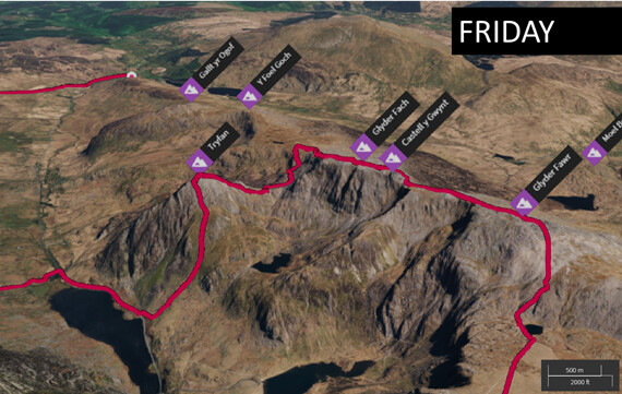
FRIDAY 17 SEPTEMBER
©Crown copyright 2021 Ordnance Survey. Media 018/21
©Crown copyright 2021 Ordnance Survey. Media 018/21

View from the tent on Friday morning
A check of the MWIS.org weather for the day suggested 25-35mph winds on the summits, with the possibility of rain. Much worse than that, and I did not fancy climbing over Tryfan. I would have to see how it turned out.
The tent was down and I was off at about 0800hrs, taking my time to descend in to the Ogwen valley which was already busy with parked cars and camper vans. Coups of camper van owners were drinking coffee and chatting in each of the laybys as I headed round o the foot of Tryfan. Climbers, walkers and scramblers were pulling bits of gear out the backs of cars – this was a buy place even on a Friday morning in mid September.
Bot half way along Llyn Ogwen a carpark marks the start of the next part of th trail – with any luck the next time I struck tarmac should be in Llanberis, the following afternoon.
The route climbs up stone steps heading first towards “Australia Lake” (Lyn Bochlwyd), however a fork heads off in a more westerly direction, following a grassy rake directly towards Tryfan. At about 750 m the grass ends and the rock begins.
At this point the wind had picked up strongly – well above 30mph, with some quite nasty gusts. I was preparing myself to turn back if required, as I did not want to risk ending up on difficult ground in gale force winds. I sat and rested on this boundary between rock and grass, observing the view down into the Ogwen valley. The Bangor to Capel Curig service bus was making its way along the Ogwen Valley, having just climbed past Ogwen falls. To the north the Carenddau mountain range was sitting in bright sunshine, whilst to the south the Glyderau (my destination today) were holding onto a thick mist.

Ogwen valley viewed from high on the west face of Tryfan
The road (the A5) reaches a height of 312m at Ogwen, and was re-engineered by Thomas Telford between 1810 and 1826 as the Holyhead to London trunk road. The height of the road makes the 918m elevation of Tryfan seem a little loftier than it actually is. Indeed, for a hill almost as high as Scafell Pike, Tryfan appears modest in stature, as it is overshadowed by the Glyderau. Despite this, Tryfan dominates the valley, and had been a constant pull on my gaze throughout the first day. The hill has somewhat of a reputation as a difficult climb; I am guessing this arises due to the proximity to the road, and apparent modest height attracting a diverse range of people to attempt the climb of the north ridge.
The summit was well in reach now, and after finishing a snack of some chocolate covered raisins I tightened the straps on my pack and headed up again. With the exception of the wind, this was appearing to be the “easy way” to the summit, which was now only 200m above me. The route continues on a short length fo scree path before a steep climb beings over blocks and boulders. There was no exposure on this route, and no difficult moves – just steady climbing block after block with easy route finding and no risk of taking a wrong turn. The path stays within a gulley on the west face of Tryfan and was well shielded by the wind. Eventually the route topped out near the col between the north summit and the main summit.
A group of well-equipped scramblers (ropes, carabiners etc) appears at the col at the same time, and headed straight up a nasty looking rock face. I was not at all keen on this option, and scouted around a little for something easier. After traversing south around 10 to 20m I found a continuation of the “blocks and boulders” gulley, that was more suited to my taste.
After a final 10 to 20m of height gain, all of a sudden, I was at the summit. The ascent had been much easier than expected, and much more fun. The summit forms a small plateau of broken boulders, and with the wind at around 30 mph I found a large rock to shelter behind. The rock plinths of Adam & Eve mark the very highest point; I sat watching others clamber up but nobody risked the leap across in the strong wind.

Adam and Eve
I opted to use the handheld and RH770, and at 1215 BST called cq. First to respond was M0WML/P on G/NP-027 Dufton pike (which I had cycled past only last month, on the way up to Cross Fell), followed by M0WBG, GW4ZPl and G1PIE. A pleasant activation followed, with around a dozen QSOs concluding with M0WCW/P on G/NP-010.
I walked around the summit a little more, admiring the views, and then made my way southwards hoping the descent would not be too difficult. When carrying a large pack, the descents are always more problematic than the ascents. Down climbing facing in presents problems with sighting of footholds and the weight of the pack pulling off balance. Down climbing facing out is limited by t6he pack catching behind. For these reasons I carry a length of around 10m of thick paracord to allow me to lower my pack over anything too difficult, and then climb down behind.
The only significant challenge on the descent was the first step off the summit which requires walking onto a flat slab of rock before dropping down a 1.5m step. The problem here is that the opposite side of the step consists of a sheer drop of several hundred meters. With the wind gusting to 30mph, and the rock slap polished smooth it would take significant confidence to stand atop the slab with a big pack. I navigated this step by lowering my pack, as described above, and it was then an easy downclimb. The climb down to the south col was very simple – easier than many lake distruict summits – and would also make a good route up (except for that last step). I really enjoyed the descent of Tryfan and at no point felt any further danger. That top step is perhaps not as hazardous as it appears as the slab slopes away from the cliff edge.

Bristle ridge viewed from south ridge of Tryfan
The sun was now shining and I had cleared what I expected to be the crux of the four day trek, all was feeling good. I even found some water in a small pool around SH 662 590. At Bwlch Tryfan I looked up towards the Bristle Ridge scramble – some walkers/climbers were making their way up. I was taking the much more sensible miners track.
A terrifying scream came from the hillside, and repeated several times. It turned out to be a goat, but had a really human quality to the noise that made me not-so-sure at first!
Onto the miners track, and a gentle gradient began taking me up onto the Glyderau. As the ridge was crested the weather changed, and I donned waterproofs. Visibility was down to around 30m, and the mist/drizzle was being swept across the hill by a strong wind.

South side of Tryfan viewed from Miner’s track
The path here is wide and easy to follow, heading westwards along the main ridge. The climb up to Gyder Fach took longer than expected because I first tried looking for a route to avoid the summit by following the 930m contour, but not being confident on the terrain ahead and with visibility poor I back-tracked to the main path and headed over the summit.
The summit was fascinating with sharp rock formations and the famous cantilever stone. It was no place to loiter and I quickly headed down, passing another walker who complained to me about the poor visibility.
The next kilometre of walking was very easy – just a gravel path with no significant obstacles. By the time the summits of Glyder Fawr (GW/NW-003) was reached the weather really was foul. The wind was around 40mph+ with rain and low visibility. This was going to be a short activation. Using the handheld I called CQ at 1630 BST, to be greeted by MW7BIA/P on GW/NW-044 followed by GW4ZPL, GW4VFL (on GW/NW-069) and M0WBG. Two further QSO’s, from G1ACD and MW7GWF completed the activation.

unpleasant conditions atop GW/NW-003 (Glyder Fawr)
The dark rock formed spiked crowns of crags, with howling wind and driving rain this felt like the mountains of Mordor. Not wanting to go wrong here, I took time to check the map and set a good bearing on the compass heading north west and then north. A tundra like plateau, is followed for around 500m, with the path indistinct in places until a muddy scree chute is met. Dropping around 200m to Llyn y Cwn.
All of a sudden the wind had dropped, and I was back in more civilised ground. This was glorious camping territory. The broad col between Glyder Fawr and Y Garn (GW/NW-004) is perfect for camping, with ample water, plenty of flat grassy patches and some crags to shelter the tent behind.
The tent was pitched on a small hillock, away from any boggy ground. Dinner tonight was Salmon with pasta (dehydrated). I was soon in my sleeping bag ready for a good nights sleep.

Friday night camping spot - between GW/NW-003 and GW/NW-004
At around 2130 BST I was woken by a couple of walkers near to my tent, looking for a camping spot. Fortunately they quickly put up their tent and went quiet. They were off early next morning at 0600 BST, giving me the place to myself again.
SATURDAY 18 SEPTEMBER
©Crown copyright 2021 Ordnance Survey. Media 018/21
©Crown copyright 2021 Ordnance Survey. Media 018/21
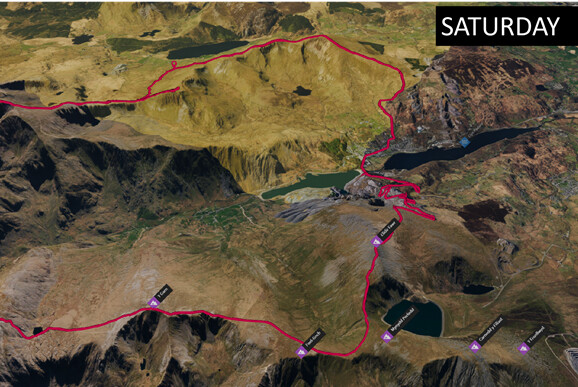
I set off from the camping spot at around 0820 BST, for the short distance to the summit of Y Garn (GW/NW-004). This must be one of the easiest 8 point summits I have ever done, taking only a few tens of minutes to reach the summit along a easy track.
The weather was fine, although mostly overcast. Views from the summit of Y Garn were spectacular, giving a great vantage point of my ascent route up Tryfan, across to the next summit (GW/NW-005) and across the valley to Snowden – where I hoped to be tomorrow.

Flowerpot antenna on GW/NW-004
I setup the 7m pole and flowerpot antenna, again using my backpack as the antenna support and called CQ. GW4ZPL responded first, followed by MW0JKS/P on GW/NW-012, EI3ISB and MW7GWR, I made a good few contacts, ending with GW4VFL/P from the carpark of the Holyhead Travelodge.

View across to Tryfan (GW/NW-006) (and the route I ascended) from GW/NW-004
Back on trail, the route across to GW/NW-005 looked straightforward, and sure enough by taking the avoiding route around Foel Goch (following the 750m contour and below) and cutting the corner to miss Mynydd Perfedd the route was quite short. The eastern ridge of Elidir Fawr looked very narrow when viewed from Y Garn, but posed no problems.

Route across to GW/NW-005 (Elder Fawr)
I was above the valley mist; the dam of the Marchlyn Rerservoir giving the effect of an infinity pool. The rocky summit of Elidir Fawr is just wide enough to hold a summit shelter, but with the weather being fine I sat on the ridge outside and called CQ.

Infinity reservoir on the side of Elder Fawr

Operating atop Elder Fawr
MW7GWR called in first, with GW4ZPL, G6LKB and MW0JKS/P (in GW/NW-012) to follow. I stayed atop the summit for almost an hour – on the assumption that the descent to Llanberis would be quick (the town looked so close!). I made Summit-to-summits with MW7BIA/P (GW/NW-051) and MM0JLA on GM/SS-123. The activation ended with MI0AIH from County Amagh and MW0SLX.
At this point I may have made a poor route choice, following an easy scree track off the north face of the summit onto the grassy hill of Elidir Fach. The positioning here is highly deceptive; Llanberis town looks so close, coupled with the gentle grassy top of Elidir Fach and a tarmacked road just 200m below the assumption I that Llanberis will be reached in around half an hour.
However, the tarmacked road is of no use, since it heads on a huge detour northwards. I opted to head through the disused slate mine, following a vermicular track that went on-and-on. Always anticipating being just 10 minutes away from a portion of fish-and-chips, and having no water reaming, I maintained a strong pace. It turned out to be a long walk, and it was around 1400hrs when I arrived in Llanberis. Fortunately the fish-and-shop shop was open – and the food quality was very good.

Llanberis - so near yet so far
On reflection, a quicker route to Llanberis may have been to descend the south face of Elidir Fawr. One advantage of my route was the chance to view up-close some the slate mining features that have gained this area UNESCO world heritage status.
Two bottled of Vimto, and a large fish-and-ships later, I headed out of the village at about 1445BST. After the quiet of the hills over the previous two days, the busy village did not feel like a pleasant place to halt for long.

Easy walking up Moel Ellio (GW/NW-022)
The route up to Moel Ellio (GW/NW-022) was a pleasant after-dinner walk, taking a gentle grassy slope. I drank my third bottle of Vimto on the way up, feeling a bit sluggish as I digested the heavy lunch.
The weather was closing in by the time I reached the summit. A thick mist shrouded the top, and it felt like rain was ahead. I was pleased to find a substantial shelter, with good slabs of tone to sit upon.
Using the handheld gain, I called CQ to hear GI4SZW first, followed by GW4ZPL, 2W0GYF/P and MW0RSV/P. I was then particularly pleased to get MD0RIF/MM – aboard a boat heading into the Isle of Man. Final call was from 2E0MIX who encouraged me to get moving as it looked like the weather was turning – he was right.
Heading off the summit, the mist cleared and I took some good pictures back across to Llanberis. My objective at this point was to find a water source. I headed along the ridge, which reminded me of the High street range in Lakeland – nice and grassy.

Easy walking down Moel Ellio (GW/NW-022)
I made good time along the ridge, and within short time was descending to the col between Foel Goch and Moel Cyngorieon (GW/NW-030). Several great spots were available to pitch a tent so I dropped the pack and went hunting for water. Descending both sides of the col yielded no water, and so after around 30 minutes, I gave up, and headed south towards the Snowdon ranger track, where a more substantial stream was shown on the map.
I eventually camped at SH 575 552, adjacent to the Snowden Ranger Path. Ust after getting into the tent the rain started – heavily and persistently. I didn’t cook that evening, satisfied with the good lunch I’d had in Llanberis.
The rain continued through the night, I was occasionally wakened by the clang of a nearby gate as late-night walkers and cyclists headed up and down Snowdon.
SUNDAY 19 SEPTEMBER
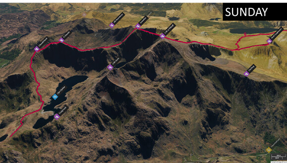
©Crown copyright 2021 Ordnance Survey. Media 018/21
The weather forecast for Sunday (from MWIS.org) told of fine weather, no wind and potential for sunshine. At 0800hrs the rain was continuing to fall, and visibility was extremely poor. I set off For Moel Cynghorian, taking a steep grassy slope to the summit. The weather on the top was poor, to say the least. The steady rain turned torrential as I called CQ. GW4ZPL responded immediately, but then nobody followed. I needed three more QSO’s to qualify. 2W0NLH/P eventually followed, and then MW3DLA after further persistence. I stood atop the stile to try and get a better signal and was about to start putting up the telescopic pole. Getting absolutely drenched now, I asked specifically if anyone could give me a fourth contact and GW6TKK called in immediately – thankyou. 2I0NIO then followed to give me total of five contacts, I was not hanging around for any more.

Sunday morning - not the weather that was forecast
At this point my ‘phone got a soaking as the plastic lunch bag I use for protection failed, my cheap camera was also soaking wet and not working.
I quickly made my way back down the grassy slope, and began the march up to Snowden. I chatted with two walkers coming the opposite way, who had decided to give up due to the weather – they also had read the good forecast the night before and were very disappointed. I pressed on, and spoke to a group of three walkers who had come over the summit, ascending the Pyg Track at 0400 BST.
The weather started to ease off as I gained the main ridge, and I could see shadows of walkers moving along the Llanberis path, following the railway. Joining that main path, I was surprised at the number of other walkers – it was really very busy.
The summit of Snowden was, to be frank, a disappointment. The café, railway and crowds mean this does not feel like a mountain top – it was more akin to a cheap tourist trap. I setup the flowerpot antenna and called CQ.
GW4ZPL responded first, followed by GW4VPX, M7LLG and MW1CKK/P. I made a few more contacts until things went quiet and then packed away – I wanted to get away from the crowds. I was glad to get away from the summit, and begin the decent of the Watkin path. The mist cleared after dropping the first 100m of elevation, and I was greeted by a great view across to Y Lliwedd. The sharp edged ridge of Y Lliwedd looked challenging, unfortunately my ‘phone was totally broken following its drenching and so no phot could be taken.
After a rest at the col, I began the climb up to the last summit of the walk. Similar to Tryfan, this was a series of easy blocks, giving no particular trouble. Several large platforms ad ledges gave good options to pause on the way up.
The summit was surprisingly grassy, and a pleasant place to sit given that the sun was now shining strongly. I called CQ on the handheld/RH770 to be greeted by G1ACD, GW4ZPL, G1PIE and M1DYU. Final SOTA contact of the trek was MW7DBF.
I was pleased to have completed my plans of eleven summits and 82 points – now I just needed to get down and home.
The descent from Y Lliwedd was easier than I had feared. The ridge walk is a good track, with no scrambling required. The climb down to Llyn Llydaw requires some clambering over wet rocks, but they are rough and ragged giving good traction.
Back in the valley I joined the miners trail to the car park. On weekends this carpark has a great bus service, and sure enough within 20 mins of arriving at the carpark, at 1715 BST, I was aboard a bus to Bangor. I was the only passenger for the whole scenic route, and given a great tour of much of the route I had taken over the previous few days. The bus connected well with a train at Bangor, and by 2300hrs I was back in Cumbria.
On the route down from Y Lliwedd I had chance to use the radio for a purpose. Since my 'phone was broken I called out to GW4ZPL, who very kindly passed a message on to say I was down from the mountain and on my way home. Thanks very much if you read this.


 !
!