My activation of VK2/ST-009 Mt Palerang located approx 45 kilometres east south-east of Canberra, which did not go exactly to plan on January 1st 2025.
Here is a link to my tale! ( Sadly true!) Your constructive comments always welcome… and should another person ask me - yes I do own and know how to use a compass… I just need a new one which is not set in cheap plastic and broken!
You came out uninjured. We are all pleased about that.
Your military training no doubt helped you retain a clear head and not panic.
Your recovery plan worked.
I know you are sick of people suggesting you add a compass to your kit with a map. That’s the opinion of many activators and is worth considering. Even a cheap compass points North. Brass cased ones are not expensive and are fairly durable. I have a compass in all my rucksacks.
Kudos for taking the trouble to share. Others will learn from this
G;Day Ron,
What I did not mention in my write-up was the fact that I DO have a compass - it has banged around in my backpack for years - and when I noticed it was damaged, I took it out… and promptly forgot about it… All can now rest assured that a brand new Silva Ranger MS compass (via Amazon) will be delivered tomorrow!.. I have also ordered a replacement PLB…If I say so myself, worth every cent!
Yes, I have to say that my combat survival training kicked in, almost without my realising it…“Protection, Location, Water, Food” .
My view is it is essential that stories like this get published so that everyone else can see how to recover from bad situations. Even experienced walkers need to see how others have acted.
You appear to have rather a lot of battery powered devices which as you have discovered can and do run out of battery power.
One of the biggest issues reported by MR teams here in the UK, is a similiar problem, and they end up rescuing folk whose sole means of navigation is their phone or other battery failure.
Well Bill you discovered the Achilles Heel of the Garmin GPS64. I found out that the unit is not tolerant of batteries that have had some previous use. The batteries were probably fine when you last used the unit, but were about depleted… that is as far as the GPS64 was concerned. I fit mine with new cells before each outing and take spares with me as well. I find the “used” cells I take out the unit will run lots of other odds and ends around the house, so they are not wasted.
I like to have some form of back up for most of the electronics I take up the summits, but carrying two main radios is definitely overkill. A handheld is always useful, even if the main radio covers 2m FM.
As for paper maps, make sure they cover a reasonable distance around the summit in all directions! I’m sure many of us at some time or another have set off on the descent in the wrong direction. I certainly have after an actjvation at dusk.
As for paper maps, make sure they cover a reasonable distance around the summit in all directions! I’m sure many of us at some time or another have set off on the descent in the wrong direction. I certainly have after an actjvation at dusk.
[/quote]
That was one of the reasons why I published my accideant and subsequent rescue a couple of years ago… Bad things happen, but its important to share those moments, so perhaps others can learn from them.
Absolutley, and a compass! doesnt even need to be a super duper one, as long as it shows north, and you can follow a bearing off it… its good enough!
Your story is indeed full of lessons we should all note, especially in the Australian summer. I am deficient in the emergency contact department and will address that soon.
Nowhere in your story have you mentioned details of the weather conditions in which you were climbing, operating and then descending. Northern hemisphere activators may well overlook the assumed situation on the 1st of January, perhaps presuming a summer like their own. Here on that day it was hot and dry. In this area, “Hot” means “over 30C by 11AM and probably 33+ by mid afternoon”. It was probably still 30C even at 6pm local time. This is a critical factor in your water requirements and is why you ran out of water relatively early in the extended walk you were forced to take. The water you took with you was perfectly adequate if you had found your way back to the car in about the same time as you took to reach the summit. You comment that the creek was dry and that’s due to zero rainfall in the previous months in that area. Again that may be difficult for northern hemisphere activators to appreciate.
You mentioned that your Garmin GPS64ST was looking fine for battery condition at the start of the day. I have an earlier model, the GPS62S and that does not permit internal charging of the cells. I find its better to use quality dry cells, not rechargeable. They start at 1.5v and last a long time. Rechargeable cells start at 1.2v when fully charged. My model does not last as long on one charge on NiMH cells as it does with good quality 1.5v cells. Again though, the hot temperature yours faced is likely to have hastened their discharge. Apart from upgrading to the model used by the search and rescue team, I don’t know what you could do to improve that situation. I carry spare AA cells in my emergency kit (which also contains BNC adaptors, SMA adaptors etc to rescue the activation from a failure due to a missing connector). If this would enable your Garmin to come back to life, perhaps thats a much cheaper alternative to forking out a king’s ransom for a new model.
As you say though, you were a winner in the end and we are all relieved at the outcome. Good on ya.
In case it helps - I have a basic Garmin Etrex10, which uses two AA cells. In the settings, you tell it what type they are, eg alkaline, NiCd etc. I guess the only difference this makes is to determine the voltage at which they are depleted? May account for early power down if this setting is wrong.
Anyway, I carry a spare set with me.
Thanks for reporting your experience, and glad it worked out.
Lots of useful info and a great explanationof how the wheels can still come off even if you are well prepared. I really appreciate you sharing.
None of the below is a criticism of your specific set up or circumstances.
My background is as a regular hill walker/mountaineer for 40 years. Qualified as an outdoor leader and Mountain Rescue volunteer for 15 years.
An alternative to a PLB is an InReach or Spot device. Obviously there are cost implications. But you can get a message out and in, even when there’s no mobile signal or VHF repeater coverage. You can also have tracking running in case you are incapacitated and unable to call for help. I have a PLB also (McMurdo FastFind). It is still very easy to be out of mobile coverage, even roamed emergency call coverage, even in England, let alone the generally more upland areas of Wales, Scotland and of course proper wilderness areas in many SOTA Regions
Another possibility is to set up your HF station assuming you can get the antenna up?
Paper map and compass back up is really essential (plus skills to use them).
Good writeup and thanks. Have a Garmin 750T GPS and noticed that even when unused it will drain the batteries so alway carry a couple of spare pairs of alkaline cells. At night when camping and not using the GPS pull the cells out just in case.
As well carry a PLB1 and have had the batteries changed as required.
What use is a map without a compass? However, we are all open to thinking that we know the way we reached the summit and set off without checking. When it happened to me on Beacon Batch G/SC-003 I was rushing to get to my 6th and final summit of the day… no excuse I know. Thankfully patient chasers ignored the lure of Saturday evening TV and came on to work me on the last one.
Just to add a further comment on the GPS64, I use good quality non-rechargeable cells. Rechargeable (NiMH) cells typically present a lower voltage which I found to be half the problem. I don’t recall experiencing this with my Etrex, but it’s years since I’ve used mine.
I have owned a GPS64S for 8 years and never had a problem using AA NiMH batteries. Fully charged 2.4 Ah batteries last a full day in the Aussie bush. I always charge my NiMH batteries external to the 64, I don’t use the internal menu driven charge option.
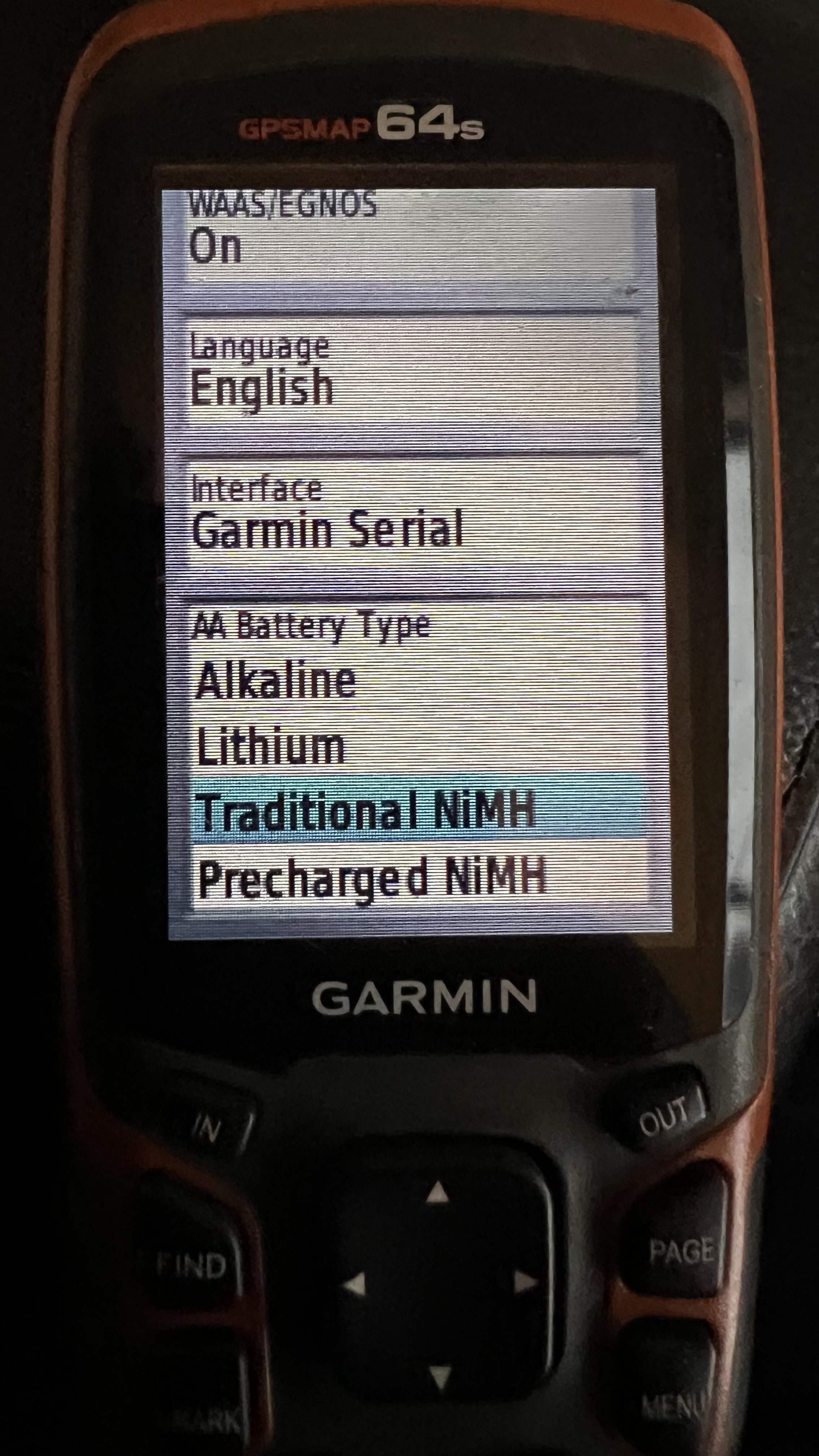
Are you configuring the 64 for operation with NiMH batteries. Main menu > Setup > System > AA Battery Type
I rarely carry a map these days. Mine are mainly used in the dining room table for route planning. Military grade electronics in my Garmin with InReach, phone mapping for backup, power bank. Silva compass, watch with barometer, altimeter and electronic compass.
The thing with a map is that most folk leave it in their pack until it’s too late. I rarely see a hill climber with their map slung around their neck in a plastic pouch these days. With detailed electronic mapping, you can see where you are at an instant.
Mapping is one thing, but reading terrain, slope angles and shapes from a map and translating that into a picture in your head, then comparing that to the land around you, is a skill that comes with practice.
Of course, I’m not criticising in anyway. I’m not used to hiking in heavy vegetation and am glad to hear it all ended ok!
I once, long ago, made the mistake of following a GPSr’s pointer through dense Aussie bush. The map I didn’t have would have shown me that three sides of the square(-ish) would have been a far better bet; at least three times the distance, but a much easier path that would have taken a quarter (maybe even a tenth) of the time the “short” cut took.
…I always put a map and compass but can’t remember the last time I used a paper version, as others have said it can’t go flat, but it is starting to be of limited use without glasses. I can operate my phone, the KX2 and write something resembling a paper log without glasses, but on the OS maps the 10m counter lines disappear, and the paper version does not have a zoom function! So for me the item I need for my plan B is remembering my glasses… (I carry an Inreach with GPS, Watch with GPS, Phone and a small USB power bank to recharge either the phone or Inreach (Which updates tracking points)… My personal worry is less about navigation, and more about knee / ankle injury in a remote spot, hence the Inreach. If someone does ever need to carry me off the hill I’d rather they knew where I was rather than spend the first 24 hours guessing… Thanks for sharing
I usually carry a map too, unless it’s a hill that I absolutely know like the back of my hand.
Yes, I’ve find that the thumb and forefinger zoom feature doesn’t work with the physical OS maps also.
I can’t remember the last time I used my Garmin GPS, I found it in the shack a few days ago and removed the batteries, which should have been removed long ago! Thankfully there doesn’t seem to be any leaking or corrosion.