The first two weeks of November 2025 were the time frame for a SOTA expedition to northern Germany by Jürg, HB9BIN, and Markus, HB9DIZ.
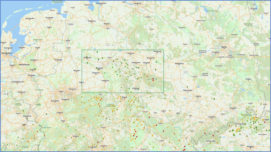
Anyone looking at Germany on SOTLAS (www.sotl.as) will notice not only the many red dots in the south, but also the northern end. A fairly large area contains many dark and light green dots, including a few olive-green dots. By chance, this area was still one of the “blank spots” on Jürg’s SOTA map. Jürg is known to have been almost everywhere for SOTA, so it was only a matter of time to explore this area as well.
Jürg often travels abroad with his XYL Franziska. However, her enthusiasm for summits in forests had previously been somewhat limited. So, we agreed to complete this SOTA expedition as an activator duo.
The original German version of this travel report has been published some days ago in “Sächsischer Bergkurier”, a lovely traditional online gazette around the Saxon Mountain Competition – see # 429 in their table of contents. Bernd, @DL2DXA, a frequent SOTA chaser and S2S partner, is one of the editors and had asked shortly after our return home. Why not? The “Sächsischer Bergkurier” has often looked beyond Saxony’s borders for mountain radio, and I always enjoy reading these reports. This translation is published here in the SOTA Reflector for the international public. It shall not only report on our experiences, but also encourage people to visit this beautiful area.
Our expedition area
Where exactly did we travel? In terms of cities, my standard answer was “between Osnabrück and Goslar, or between Hanover and Göttingen”. Most people around here were familiar with those locations. Geographically, our trip focused on the Harz Mountains and the Weserbergland region. Politically, the area is mainly located in Lower Saxony and North Rhine–Westphalia.
For insiders, it can of course be specified in more detail: The summits are located on various ridges in this area – listed here with their highest SOTA mountains:
- Top of Harz Mountains (Brocken, DM/SA-001, 1,141 meters above sea level, highest point in northern Germany, and Wurmberg, DM/NS-001, 971 m)
- Upper Harz Mountains (Schalke, DM/NS-008, 762 m)
- Central Harz Mountains (Aschentalshalbe, DM/NS-111, 685 m)
- Lower Harz Mountains
Around the Weserbergland region:
- Solling (Grosse Blösse, DM/NS-092, 528 m, highest point in the Weserbergland region)
- Lipper Bergland (Köterberg, DM/NW-135, 496 m)
- Alfelder Bergland (Blosse Zelle, DM/NS-136, 480 m)
- Reinhardswald (Staufenberg, DM/HE-138, 472 m)
- Vogler (Ebersnacken, DM/NS-129, 460 m)
- Süntel (Hohe Egge, DM/NS-126, 440 m)
- Göttinger Forest (Mackenröder Spitze, DM/NS-147, 428 m)
- Deister (Bröhn, DM/NW-122, 405 m)
- Bramwald (Heidelberg, DM/NS-143, 402 m)
- Bückeberg (Bückeberg, DM/NW-125, 373 m)
- Teutoburg Forest (Stapelager Berge, DM/NW-089, 365 m)
- Weser Mountains (Hainholz/Lange Wand, DM/NS-117, 320 m)
- Wiehen Mountains (Heidbrink, DM/NW-078, 320 m)
- Ottenstein Plateau
- Burgberg
For us Swiss, it is somewhat unusual to call mountains below 1,500 meters “mountains”. But the local naming convention is clear. Some of the historically old names often include the word “mountain” or "mountain range”. And when you’re standing at 150 meters above sea level and have to hike up to 400 meters, it can be quite strenuous at times even here. Unless you have a bike!
That was a special thing of our tour. I was traveling with Jürg, the driver and cyclist, and Jürg had decided to take his e-bike with him to protect his knee joints. Almost like David and Goliath, I usually said “Goodbye!” at the trailheads with my backpack very soon and set off on foot immediately, while Jürg first had to get his heavy bike ready and then pack it up again after the descent.
I’m not bad at hiking, even though I now have some knee problems that are no longer trivial. Thus, I had fun finding out how far I could get before Jürg caught up with me on his bike. To my surprise – and with a certain amount of pride – I was frequently at the summit before him. We often even didn’t see each other again until we were back down at the parking lot, as I was fully mobile on my feet and could also use narrow bypasses. The frontrunner was summit Aschentalshalbe, where I was already finishing the activation after a 4 km walk when Jürg rode past me to the summit. Of course, the reverse also happened, with Jürg whizzing past me with a friendly encouraging remark and a smile.
Finding possible parking spaces took up a large part of the travel preparations. Sotlas and other relevant sources did indicate good or suitable parking spaces for most destinations. However, with cycling in mind, Jürg sometimes chose alternative starting points from which he wanted to reach his destination on cycle-friendly paths.
Most of the time, that worked out fine. Occasionally, I heard afterwards that a path had not been passable after all, or that other reasons had necessitated a detour. As long as the parking lot and summit were the same for both of us, it didn’t bother me much. Once he got going, Jürg was quite speedy on his bike. However, given my own knee problems, I occasionally pushed for other solutions during the preparation phase when my hiking route would have been unduly extended by a different parking lot. I had great respect for all the places where different starting points were up for discussion. Fortunately, however, this was completely eliminated by consensus in view of safety concerns. There were no incidents where we had to search for each other with flashlights in the forest.
Jürg liked to cycle to the highest point possible. Given that the forests all looked pretty much the same, I was much more down-to-earth and was usually satisfied to reach the activation zone. This took some of the pressure off our schedule, so that Jürg never had to wait for me at the parking lot for too long.
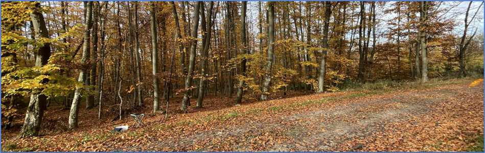
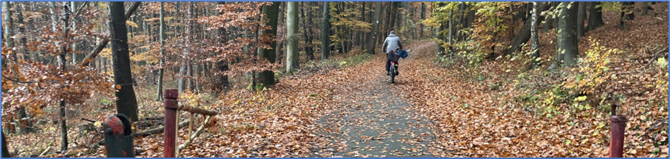
This tour is perfect for lovers of autumn forests! Just like last year in the Northern Vosges, this region had plenty to offer, except for the red sandstone rocks found in the Northern Vosges, which are part of that region’s charm.
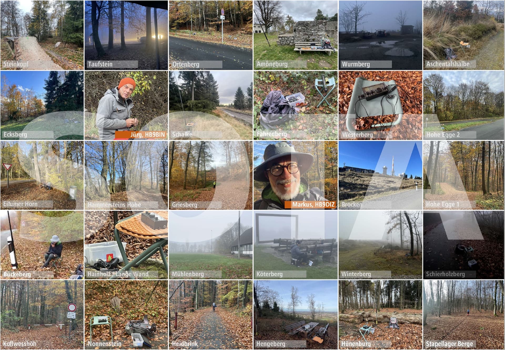
The pictures of the shacks in nature are similar over a wide area. Some summits are located in beautiful beech forests, which radiate a great sense of calm with their brown carpets of leaves and straight, venerable trunks. With a little sun (but also without lighting), it’s something really great and balm for any personal batteries! I fondly remember Heidbrink and Stapelager Berge.
Of course, there were other views and vistas:
- the view into infinity at Brocken (when it doesn’t end there at the horizon or in fog);
- the large parking lot on Köterberg and – without fog – a somewhat smaller infinity;
- various transmission towers, because it’s not just radio amateurs who like to sit at the top;
- endless forest paths and forest roads that also enable forestry work at the top;
- mining lands and their recultivation;
- all kinds of undergrowth, especially blackberries;
- windthrow and the vastness or emptiness that came after it;
- tourist facilities and huts of all kinds;
- or simply . . . nothing!
Due to the long distances from home, we had planned two full days for the outward and return journeys. To break up the distance, we also visited a few summits along the A5 and A7 motorways.
Our expedition was a SOTA trip, but we also picked up POTA and, in Jürg’s case, WWFF references where these were available at the summits. For POTA, the online map www.pota-map.info by Heinz, DK5UR, named here lovingly “the Heinz Map”, was a great tool, as it is the only way to reliably determine the overlaps between POTA areas or POTA trails with the activation zone of SOTA summits on a map.
Travel planning
In retrospect, it turned out to be a stroke of luck that I had been ill for several weeks in March. This gave me time to research the expedition area in detail and compile a large Excel table with all the relevant details.
What did this table contain?
- Master data of the SOTA summit.
- Own two-digit numbers for the summits so that they could be displayed on an overview map in a space-saving manner.
- For each summit, 1-n access options from different suitable parking lots.
- For each access option, information about the parking lot, including name and coordinates.
- For each access option, information about the hiking distance in kilometers, the ascent time in minutes, the elevation gain in meters, separated into ascent and descent, and the maximum ascent in % over 500 meters of hiking distance.
In addition, there was some radio-related information for each summit:
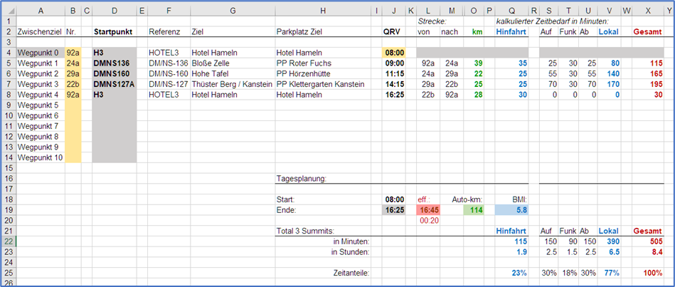
- Radio time in minutes: 30 minutes as standard for setup, radio communication and taking down, 60 minutes for WWFF solitaires.
- Information on the WWFF area, where available.
- Information on the POTA areas, where available.
- A comments field for notes of all kinds.
The time available during sick leave also led to some Excel technical exercises, all of which were interesting but of course took up a lot of time. Under normal circumstances, you don’t have this time. However, these exercises were good for keeping the brain in form after retirement, so I was happy to invest this time on this one occasion.
Which technical exercises found their way into this Excel table?
- A pivot table showing which WWFF areas could be reached on which summits. Jürg also participates in WWFF and has always been very passionate about this program. Where an area could only be reached on a single summit, he needed more time for the minimum 44 QSOs for WWFF, so I set 60 minutes instead of the usual 30 minutes of radio time.
- Another pivot table showing which POTA areas could be reached on which summits. The frontrunner was Mt. Brocken with 5 POTA references. With a minimum of 10 unique QSOs, POTA was much easier to satisfy than WWFF.
- An output table for the navigation system to quickly find all parking spaces with helpful but short names on the navigation system’s map. I used “Magic Earth” as the navigation system on my cell phone. I selected the relevant fields from the base table and then converted them into a CSV file. This file was then converted to KML format using an online converter, sent to my cell phone via email, and opened with “Magic Earth,” where the parking lots were then saved in a separate folder under “Special Destinations.” German umlauts were converted into question marks, but the labels remained legible – only a small issue.
- A one-pager with the WWFF and POTA references on one sheet. Jürg really appreciated this sheet for WWFF to keep track of mailings to and the manual log uploads by the country managers.
A copy of the latest version of this table is attached at the end of this report. The information contained therein reflects the latest state of our knowledge. Use of the information for your own purposes is always without guarantee and at your own risk. In particular, paths or parking facilities may now be closed, or summits may no longer be accessible. The author accepts no liability for direct or indirect problems or consequential damages.
The time allowed at the summit was very ambitious at 30 minutes, and there were countless little devils at the summit, so we were hardly able to keep to this schedule:
- When cycling, you can get lost more quickly and unexpectedly because you are traveling at a higher speed. You have to have a good grasp of the turnings, and there must be no unforeseen events. You also never know how well reality matches the map – my favorite plants, blackberries and nettles, tend to grow abundantly. The paths on the map were actually always at least recognizable on the ground.
- Some colleagues reported that they still needed a few minutes to reach their radio station, summit or park, which was usually a somewhat optimistic estimate.
- A few summits had access routes that had probably been churned up by wild boars and were difficult to navigate efficiently due to the many blackberry bushes, which could only be seen once on site.
- The radio weather was a bit unpredictable at times. Once, I finished my 40 m round just in time before a major solar flare.
- During an activation, it’s easy to forget the space and time around you – who hasn’t already met this? You quickly start a second band, which you then find it hard to leave. The 40 m band was already working well, and then all hell broke loose on 20 m! Pile-ups are great and keep you warm, but they take time. We’ve never left the summit after the minimum number of contacts needed.
- Some of the connecting trails and shortcuts were difficult or almost impossible to walk on, especially on the Winterberg. The official route via the forest road is very pleasant, but it is much longer and takes quite some time.
Some words about “awful summits”. Well, I actually take everything as it is on the ground. But I have elected even now, after 850+ activations, a summit as my most awful summit: the Fahrenberg, DM/NS-110. The trails were wet, dirty under the autumn leaves, churned up deeply and full of blackberries. It was very difficult to move forward efficiently. At least the SOTA summit and its access route had been entered by hand on the large hiking map at the hiking car park, hi.
The season should not be underestimated. In November, the days tend to be cloudy and, above all, short. We therefore liked to get up a little earlier to make good use of the daylight. In northern Germany, night falls a little earlier than in HB9. Since Jürg was fully booked for the rest of the year with his job as a SOTA-, POTA- and WWFF radio operator, our expedition took place in one of his remaining time slots – in November. Breakfast was available early enough in all accommodations. We stuffed our bellies or bread bags and also found good bakeries.
I used my tried-and-tested equipment:
- A KX2 from Elecraft with 10 watts, which I still enjoy using even after 10 years.
- An end-fed antenna with 20 m of wire and a 1:64 coupler.
- Earphones for good audio and the original MH3 microphone for the KX2.
However, there were also some innovations that proved to be very useful for me:
- I had switched to a 6-meter travel fishing rod from Decathlon as an antenna mast in a rod holder from Tacklemaster, which you stick into the ground with a thick metal pin. The 10-meter “Mini” mast from DX-Wire, which I had used previously, was now only used as a backup.
- I therefore hung up the antenna as an Inverted-L. The horizontal part was thus a few meters longer and sagged like an Italian clothesline, hi, as the fishing rod cannot be bent as much as sometimes necessary. This worked very well on 40 m, but also worked surprisingly well on 20 m with 5 m of vertical wire next to the operator. I was pleasantly surprised by this non-DX antenna on 10 m, where I managed two S2S with D4BHU in Cape Verde and several QSOs with the USA.
- To protect my knees, I had bought a simple camping stool with X-legs the week before. This stool proved to be very useful. After some research, I found a cheap and lightweight model at Decathlon’s online shop that was large enough and stable enough for my body size. I was able to sit down anywhere with it and relieve the pressure on my knees.
- Logging with Polo was not a real innovation, as I had already been working with Polo since last spring. It worked very well, especially when activating several outdoor programs (SOTA and POTA) at the same time. I really enjoyed these conveniences. As with my iPhone, I am not averse to the sometimes somewhat playful decorative elements in Polo. Your eyes just need to be good enough, your fingers thin enough, and your cell phone (Polo is available for iOS and Android) powerful enough. That said, there’s not much room for special requests. I’ve been told several times, “Polo has been designed that way.” But ultimately, it can do everything I really need it to do.
- Last week, I assembled the “Mini Micro” from K6ARK, which is hard to beat in terms of minimalism and is a very good replacement for the bulky MH3. The little home project was quite fiddly, but it also showed me that I can still solder small things together. Unfortunately, a defective connection cable then fooled me.
I calculated the hiking times and altitude differences on my iPhone using the MapOut app, which I have been using successfully for many years for my hiking activities around SOTA. The app also allows me to export the track and a map image with the track marked on it as a visual orientation aid for each approach variant.
The expedition area, including the outward and return journeys, covered around 50 SOTA summits, so it took some discipline not to get lost in it. I therefore limited myself to my favorite band, 40 m in SSB, while Jürg mostly started on 30 m and only switched to 40 m in CW for the WWFF solitaires. It was important for me to serve the closer chasers which are probably motivated then to visit our region of their own and help out others to complete it.
Daily planning
Accommodation was an important topic. Due to age, Jürg and I appreciate functional hotels and also enjoy basic comfort and a pleasant atmosphere to come back and start again “at home”. I appreciated that we were able to stay in the same place for several days. We only needed two hotels in the expedition area – four nights in Seesen in the east for the Harz Mountains and its foothills, and nine in Hamelin for the rest of the central and western areas. This allowed us to cover all areas sufficiently well with reasonable daily driving distances by car.
We would see how feasible that would be. As a remedy, you just skip a summit if a day is going to be too long. After 3 p.m., even with a drive-up summit, it gets dark before you get back to the accommodation. I made a rough plan of possible daily programs using a map, where I grouped geographically neighboring summits.
To help with planning, I set up a further table in our Excel: a table with the kilometers and minutes of driving between the individual summits and to the accommodations. I wouldn’t have done that if I hadn’t had so many days at home while I was sick. It was educational. I set up a template for day planning table in Excel so that I could enter the start and end points as well as the planned summits and see the total kilometers, driving time, hiking time, and radio time for the day in the total rows. This allowed me to identify and effectively streamline overloaded days from the visual planning based on facts. Of course, there were still some days that were longer resp. heavier or shorter. During our trip, the planned driving times between the parking lots were pretty accurate, apart from construction work and other Murphy’s Law situations.
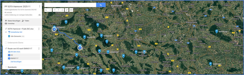
I used Google Maps as a basis for this, where I set up a map of my own, listing all the parking spaces for all the different access options. I was able to import the Excel file and display the coordinates of the parking spaces. MyMaps can also calculate distances in kilometers and driving time in minutes. It was interesting to see that an optimal sequence of summits can minimize the daily travel time.
The weather remained unpredictable. However, we were very fortunate that we could always choose one of the daily programs where no rain was expected. The little rain that fell during our trip mostly fell at night. In addition, the temperatures were mostly pleasant for autumn. We were even more fortunate with the general weather conditions, which ultimately brought us hardly any rain and pleasant autumn temperatures between 5 and 10 degrees Celsius. Unfortunately, we had numerous days of fog or high fog. The relevant weather and rain radar apps Meteoblue and Warnwetter were helpful tools for assessing the weather. The Brocken was on the program on the most beautiful day – a wonderful excursion in bright sunshine and blue skies. No fog or wind at the summit! Simply wonderful and a great memory today!
Highlights from our expedition
It would go beyond the scope of this report to describe all the summits in detail here. There are already many helpful entries on Sotlas. Also, the user experience in the colorful autumn forests was mostly very similar. We have added details in Sotlas, where nothing had been documented yet or where our experience seemed important enough to us. Some of our approaches can also be found there.
A photo collage with visual greetings from some of the summits we visited can be found at the very end of this report.
What highlights do I remember from the trip?
Day 1:
- Steinkopf, DM/HE-097: Our first summit on the way to our destination. My first one next to a mountain bike trail in the forest. I never thought anyone would ride down there in the rain. But someone did!
- Taufstein, DM/HE-017: Then it finally started to rain. Luckily, someone had built a cross-country skiing hut in the forest at the eastern end of the large parking lot. It was already getting dark and the rising fog created a ghostly atmosphere.
Day 2:
- Ortenberg, DM/HE-548: You have to come up with the idea of building a clinic on a SOTA summit first. But SOTA didn’t come along until later.
- Amöneburg, DM/HE-509: The name is a bit special, and so is the summit: a pretty, compact village on a castle hill. You can see the flat cone in the landscape from afar, even from the A5. It reminded me strongly of the Hohenkarpfen hill in the Swabian Alb.
- Wurmberg, DM/NS-001: We actually wanted to take the gondola lift up, which was having its last day of operation before the maintenance break. Unfortunately, the railway company closed early in the afternoon. There would have been signs onsite, but they hadn’t thought to put anything on their website. So, we drove up to the Hexenritt car park at 4 p.m. to use our hiking boots. The ticket system at the parking lot isn’t for everyone in the dark and with a weak cell phone signal. But after the pile-up we’ve even managed that.
Day 3:
- We received a warm welcome at our accommodation and felt well looked after for the next four days. Off we went to explore the Harz Mountains!
- Aschentalshalbe, DM/NS-111: The 4 km hike from the Knollen car park was quite a long approach. However, the forest road from the east is very pleasant to walk on. It was quite windy – luckily there are some sheltered corners in the AZ.
- Ecksberg, DM/NS-115: At home, I had figured out the shortest ascents. That wasn’t a good idea here. These paths were heavily overgrown, and I struggled several times with blackberry bushes and their long thorny fingers. But at the summit, there was a beautiful view to the north!
- Schalke, DM/NS-008: Ben, @GW4BML, had already found this summit very comfortable. We felt the same way. I had left the nice hut to Jürg, but when I came back to pick him up, I found him on top of the tower, where the antenna for 20 m worked better.
Day 4:
- Fahrenberg, DM/NS-110: I have seen many summits, but in my opinion, this is the ugliest of them all, hi. In autumn, everything is beautifully covered with leaves, but underneath, the paths at the summit are muddy, churned up and dirty at level 3. It is best to wait for weeks of dry weather before attempting to hike to this summit!
- Kahlberg, DM/NS-152: We had received a good hint for an access route from the east. This gave us more time for the pile-up at the summit, and Jürg showed me the advantages of a well-tuned antenna.
- Westerberg, DM/NS-178: The sun came out here and made the autumn forest glow beautifully. I was in such a good mood that I forgot my new fishing rod holder in the ground. It’s probably still there: west of the summit, just west of the path. If you see it, feel free to take and keep it!
- Hohe Egge 2, DM/NS-175: With the rod holder missing, I also lacked a bit of flexibility in setting up my antenna. Jürg called out early across the car park that Fredi D4BHU was QRV on 10 m in the Cape Verde Islands. After calling for a long time, he finally reached him. At last, my antenna was up: not exactly a beauty contest winner, but the S2S with D4BHU worked right away on the first call with the low-hanging Inverted-L.
Day 5:
- Eilumer Horn, DM/NS-165: The motto for this day was to stay as low as possible, because stormy winds were forecast for the higher mountains. The Horn has a huge activation zone, which also includes the Tetzelstein inn with its large parking lot. With pleasant sunshine, we were able to concentrate well on radio operations.
- Hammersteins Höhe, DM/NS-163: The planned parking lot at the former potash mine is no longer accessible, but we found a small hiking parking lot at the entrance. Here, the GPS in my navigation system led me astray, and I walked around in circles for a quarter of an hour. Once I was back on the forest road, I was back in control of the situation. Strong winds meant that this was a short activation.
- Griesberg, DM/NS-161: We didn’t see any no-entry signs at the parking lot southwest of the summit, so we drove further up the road to the waterworks facilities. From there, it was only 1 km up the tower path to the Sibbesse telecommunications tower.
- The last summit of the day was at the hotel: We had arranged to meet our radio friends Chris, @DL1CR, Uwe, @DK8OA, and Michael, @DL4ABO for a summit meeting in the hotel restaurant, where we spent an enjoyable evening with delicious cuisine.
Day 6:
- Brocken, DM/SA-001: For economic reasons, the train only runs from Friday to Sunday this November, but we are in the area from Sunday to Thursday. So, we laced up our hiking boots. The parking lot at the Ehrenfriedhof cemetery next to the B4 in the west was recommended to us as a good starting point. However, a 7 km trail – the longest single hike of our expedition. The weather was perfect: sunshine, almost no wind, good visibility, and good radio conditions. And that on Mt. Brocken! Simply wonderful.
- In the afternoon, we made the long drive west to Hamelin, where we had booked a nice bed and breakfast on the southern borders of town for the rest of our stay.
Day 7:
- Hohe Egge 1, DM/NS-126: There are several approaches to the Süntelturm from different directions. We had identified a hiking car park on Jahnhüttenweg in the southwest on the map, which offered the shortest approach to the summit and both SOTA trails. The parking lot is not recommended: there is a no-driving sign on site, and according to a hiking blog, fines have already been issued there. So, the Pötzen hiking parking lot seems best for a southern approach.
- Bückeberg, DM/NS-125: Chris wanted to bring Jürg something, so we met DL1CR again. We also kept an eye out for the POTA trail and stayed at the front of the road near the educational facility. Thanks to the access road, this summit is a drive-up. This is where DL1CR’s legendary bear video was made.
- Hainholz/Lange Wand, DM/NS-117: There are no paths to the summit here. Although the A2 motorway is not far away, the beautiful forest exudes a soothing tranquility. What a great place to recharge your batteries while hiking up and down!
Day 8:
- Mühlenberg, DM/NS-177: The first drive-up today. There is a sports field on the flat summit, where there are various options for setting up the antenna. Unfortunately, there was no sun due to the fog.
- Köterberg, DM/NW-135: A further drive-up summit, foggy here, too. Otherwise, Köterberg would be the only one of the higher summits besides the Harz Mountains with a distant view. Be careful with POTA here on the NW/NS border: the Lower Saxony part does not belong to the POTA area.
- Winterberg, DM/NS-267: One of the rarely visited summits in the middle of the hills. We came from the east from the Eschenbruch church, where a large forest road leads up to the activation zone.
- Schierholzberg, DM/NS-133: It was already getting late. The summit is an abandoned military site in the forest and looks mysterious in the twilight. A few meters before the gate, you are already in the AZ on the access road, and 40 m worked well. Quickly back down before the forest ghosts would fly in!
Day 9:
- Kollwesshöh, DM/NW-256: With changeable weather, we decided on the most remote summits in the northwest for our Sunday program. In the forest above the motorhome parking area, you can quickly reach the activation zone. At 40 m, many stations were logged in quick succession, but Jürg took a little longer for the 44 QSOs in the WWFF area.
- Nonnenstein, DM/NW-063: There were several families with children out and about here. Good opportunities for funny conversations with two-legged friends of all ages.
- Heidbrink, DM/NW-078: The ascent led through a peaceful and beautiful beech forest.
Day 10:
- Helleberg, DM/NS-155: A track branches off at the ridge, but it is already overgrown after a few meters. In this increasingly dense thicket, Jürg startled me after I had set up since I had actually expected him to be on the neighboring bike path.
- Holzberg, DM/NS-156: We started from a niche on Holzbergweg. At the top of the summit structure, the direct route north to the summit zone has been closed for safety reasons. However, the activation zone can be easily reached a little further east. The sun appeared sporadically, bathing the beautiful autumn forest in vibrant colors.
- Grosse Blösse, DM/NS-092: Here, the main road runs directly over the summit, and you can do SOTA from the parking lot. However, traffic noise on a summit is unusual. The summit is the highest point in the area, but there is no view. You don’t even notice that you are climbing to over 500 meters above sea level. My Inverted-L had a highlight here: three US chasers on 10 m within four minutes!
Day 11:
- Blosse Zelle, DM/NS-136: A comfy ascent on a good forest road to the summit zone. Jürg drove a little further up and operated at the Sohlhütte hut nearby the Wilhelm Raabe Tower.
- Hohe Tafel, DM/NS-160: At the starting point at the Hörzenhütte, the state forestry service was busy with logging work. As a result, the first part of the trail was quite muddy and full of ruts. There are two ways to reach the summit here, which have almost exactly the same length.
- Thüster Berg/Kanstein, DM/NS-127: According to the plan, this was our longest hike in the Weserbergland region, taking 80 minutes, starting at the beautiful forest parking lot of the Kanstein climbing area. The municipality had advised against using a connecting path because it was overgrown. We tried it anyway: Jürg had to turn back on his bike, but it worked quite well on foot. As a result, I reached the activation zone in half the time.
Day 12:
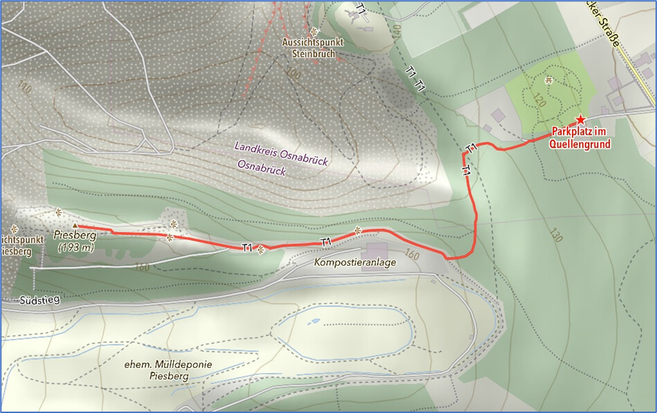
- Piesberg, DM/NS-108: Here, we were impressed by the large piles in the landscape, some from mining and others from the composting plant, which we could also smell. As a brisk wind was blowing up there, we quickly said goodbye to the outskirts of Osnabrück.
- Dörenberg, DM/NS-036: From the parking lot at Hotel Herrenrest, we found a beautiful hiking trail up to the tower. We marveled at the brave trail riders and were glad that no one crashed into the antennas.
- Hengeberg, DM/NW-148: On the footpath up to the ridge, I turned a few meters too early and ended up deep in the blackberries. After that, my cell phone kept playing tricks on me, so Polo kept complaining that I wasn’t logged in, but then mocked me because it worked again for a moment.
Day 13:
- Hünenburg, DM/NW-062: The next day, we were still exploring the heights of the Teutoburg Forest. A beautiful hiking trail leads from Gasthaus Peter to the summit. You have to look closely at the maps to catch all the POTA areas at once.
- Stapellager Berge, DM/NW-089: This summit is quite easy to reach from the north. A beautiful beech forest, freshly covered with thick layers of brown leaves.
- Steinberg, DM/NW-250: We had to hurry here because rain was threatening us. So, my chasers had to make their deal with 12 QSOs in 9 minutes.
Day 14:
- Fast, DM/NS-121: Here we hiked from the guest hut in the forest in a few minutes on wide forest roads towards the summit. Today was the most uncertain day in terms of rain, but it stayed dry and it only almost rained on Fast.
- Grasberg, DM/NS-107: The next summit was reached after a short drive. From the Wolfsbuchen hiking car park and picnic area, it’s a quick walk in the Saupark to the Hirschtor gate at the top, where the activation zone comes down to the forest road for some meters and the antenna is easier to be set up.
- Bröhn, DM/NS-122: The Bröhn, DL1CR’s home hill and registered dozens of times in my SOTA log! What a honor to to transmit here! Chris had considered visiting us again, but then decided against it due to other commitments. From the Laube parking lot, it’s just a short walk to a nice forest hut, where you just have to make sure you take the right corner of the intersection for POTA.
Day 15:
- On the way home, we had planned a stopover in Göttingen. Once again, our task for the day was to escape the rain, and we succeeded once more.
- Staufenberg, DM/HE-138: From the Staufenberg hut, you can reach the summit without a trail through a beautiful forest. The ground in the forest is cleaner than behind the hut. This summit is 10 cm higher than the former neighboring summit Gahrenberg, DM/HE-137, and has therefore been reactivated two years ago.
- Heidelberg, DM/NS-143: As a pedestrian, I quickly reached the activation zone from the edge of the forest near the sports field, while Jürg had to ride his bike much further to get there. It was getting dark quite early due to the change in weather, so this forest seemed quite mysterious. But the chasers caught up with us even here!
Day 16:
- Hoher Hagen, DM/NW-141: At the last summit, we briefly needed our umbrellas, but the drop-shaped disturbances were limited. I didn’t notice any radio interference at the summit that had been mentioned several times.
- Once the seat heating had brought us back up to operating temperature, the rest of the day was spent driving home to the south. We said goodbye to Amöneburg once again from the highway and made good progress between Frankfurt and Basle. After two weeks away, we were able to embrace our loved ones again in the evening.
And another story for the eternity
A highlight of our expedition were two S2S connections with Fredi, HB9BHU, who had short-circuited the cold season with a vacation on the Cape Verde Islands. The first contact with D4BHU is mentioned earlier in this report.
During the second contact on summit Bröhn, I had a good idea and a bit of luck. Fredi was QRV on 28.063 MHz in CW, and it would probably be a while before he would also call in SSB. Actually, I would have preferred to pack up and hike back to the parking lot. I was able to pick up his telegraphy signal well with the KX2 and the EFHW. Unfortunately, for reasons of convenience, I had left my Morse key at the hotel.
Then I had a good idea. I remembered the funny YouTube video where someone whistled Morse code into his microphone. Would that work here too?
I heard Fredi’s Morse code in SSB half a kilohertz lower. Then I took a deep breath and started a loud and sharp staccato: “Biiibibi bibiiibibi biiibibibiiibi bibibibi biiibibibi biiibiiibiiibiiibip . . .” And sure enough, Fredi answered immediately – 559 on both sides and twice the summit references. The QSO was in the bag!
I never would have thought it. You just can’t be afraid to beep loudly into your microphone. Even any wild boars passing by are sure to take off immediately, hi.
Later, I thanked Fredi for the S2S QSO and asked him what he thought of the sound and my transmission, as I had used a new key. His answer: “Basically easy to read, but strange sounding, as if you were transmitting in SSB with a tone generator.” Right, but I was the key and the generator myself, hi.
Administrative tasks
Processing the logs was always a way of reviewing the day. I always uploaded the SOTA logs on the same evening, but only twice for the POTA logs. If you participate in SOTA and POTA, logging with Polo is very comfy, as it provides a separate ADIF log file for each reference, which you can upload to the server without further processing, as long as you can use a suitable storage location like Dropbox or your own NAS. Spotting was also a quick thing once you had entered the transmission frequency.
Jürg also participated in WWFF, which, compared to SOTA or POTA, involves quite a lot of administration and leaves you somewhat at the mercy of local administrators. He still logged his QSOs with VK port-a-log, as I had done in the past. This works well for SOTA and WWFF, but for POTA you have to create and customize file copies for each area yourself, which can be quite challenging and time-consuming after a hard day.
After returning home, Bernd, DL2DXA, contacted me fairly quickly and asked if I would be interested and have time to write a report about our expedition for the “Sächsischer Bergkurier” magazine. I was happy to do Bernd this favor, as I had already spent many interesting and enjoyable hours reading countless issues of this magazine. It was immediately clear to me that this would be a time-consuming task, although I had the freedom to emphasize whatever I wanted.
Bernd’s request put some pressure on me to do some further time-consuming follow-up work: checking the summit descriptions in Sotlas to see if our GPX track or additional image material could be added. That is now also completed, although there is always more that could be done. But free time should be spent outdoors and on the radio!
SOTA travel data
The digital essence of our amazing expedition through northern Germany is summarized in this Excel spreadsheet. Use it at your own risk.
SOTA pictures for the memories
The analog essence is stored in our photo albums, but also in our hearts. The small collage just below gives you a few visual impressions. Use them at your own risk, too, hi. You can find more pictures on the summit pages in Sotlas.
We would like to say thanks for the great insights into a marvelous landscape, thanks to our local friends and supporters and thanks to our radio partners for the QSOs – and thanks to our loved ones at home for being patient for more than two weeks. Thanks all for being close and with your open ears!
Jürg and I wish you “Happy SOTA!” and look forward to see also others exploring this beautiful area in Germany.
Vy 73, Markus HB9DIZ
PS:
. . . and please receive our season’s greetings:

“How was the pile-up in the German woods?” — “Very loud!”
. . . we hope we have heard you all – hny 2026 and up to our and your next adventures!