Colin
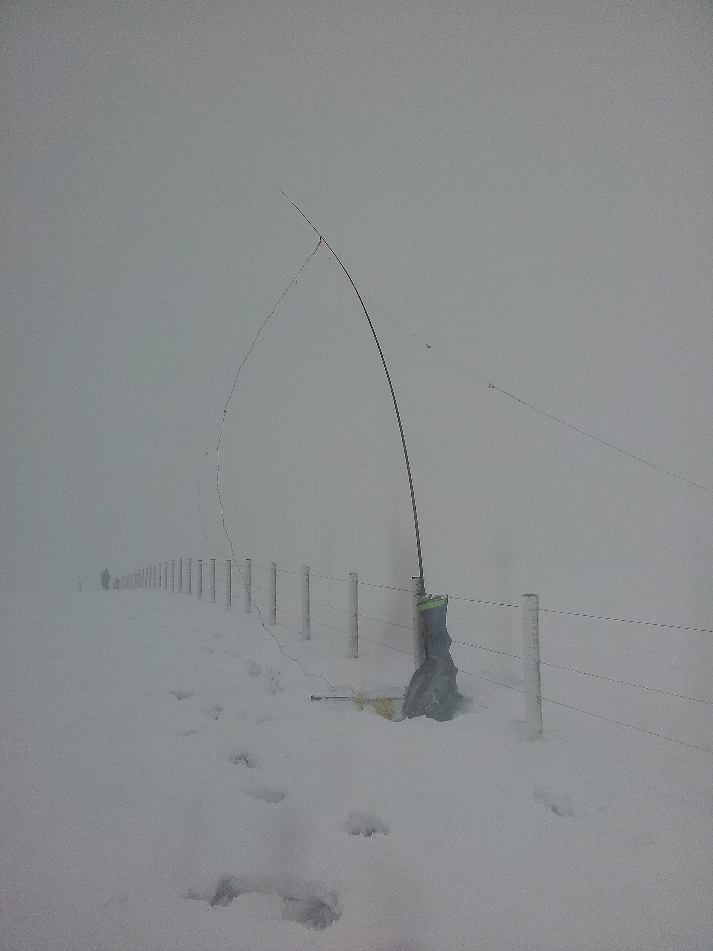
I’ve got a bothy bag too!! But I still get cold in bad weather.!!  It must have been cold for a cable to snap!
Dave
Colin
I’ve got a bothy bag too!! But I still get cold in bad weather.!! It must have been cold for a cable to snap!
Dave
Andy
Nice photographs - where’s the one with the track with the bothy taken?
Dave
@G8CPZ
Andy,
Slightly off topic but never mind:, *“By contrast, the British and European technique has the SK near the front of the desk and there’s less wrist movement so less ‘glass arm’.” . I’ve heard that stated before but I’ve been on a number of UK ships/stations, where the keys haven’t been fixed to the front edge and we also kept our elbows on the table. I’ve also worked with plenty of European operators who kept their keys well away from the edge and rested their elbows on the table too. Sometimes you worked in offices where the keys were fixed (always on the edge of the desk), and sometimes the keys were on wire leads - which is what I liked!).
Dave, (ex RN RO)
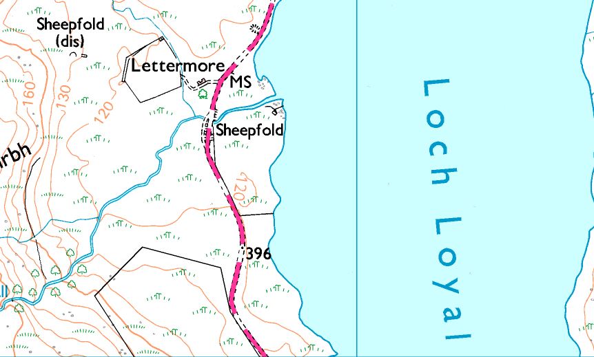
Ben Loyal GM/NS-052 from Loch Loyal at Lettermore. The old building is to be restored and put back in use as a house.
Hmmm… looks like the map has the track on the wrong side of the building. Mistakes on Her Majesty’s maps? Never!
Re Andy’s pics. Fair weather activator? Haven’t I read about some activations where you were up to your butt in slush?
73
Ron
VK3AFW
Thanks, Dave, that’s very interesting. This is a wild guess: I suspect the difference in SK usage on both sides of the Atlantic dates back to the first half of the 20th century and dominated by SK training methods used by the military in the world wars. Maybe since then even profession training methods became less prescriptive on arm posture. And for self-taught amateurs like myself learning in the 80s and 90s, it was completely ad-hoc. I’ve unwittingly used both SK positions over 15 years (until I switched to iambic paddles) and didn’t realise the significance until I read an article a few months ago.
If anyone knows the real history, please let us know.
45 activations in 2019 in 8 assocations (G, GM, I, HB, HB0, DM, DL, OE, F). 31 in the UK.
Oh Yes!!
There is apocryphal evidence that they intentionally put some non-critical errors into their maps to detect unlicensed copies. Whether true or not, I tried to follow a very obvious mapped track on a hill in the Cairngorms which failed to materialise and a current satellite view didn’t show that track on the ground. A VERY long detour needed to get over that gotcha ![]()
Well I wasn’t in Scotland that much last year, so there was plenty of time for the sun to shine. Perhaps this photo (Windy Standard 30th December 2017) will make you feel happier with my remark… and yes, my keying was dire on this occasion as the contacts got wet. At least with a simple straight key I could keep blowing the water away.
I think Winter conditions in mid-Winter are to be expected. ![]()
It looks like 2019 was both the wettest and sunniest for SOTA in GM. 11 activations out of 31 having wonderful sunny weather including many in Winter. Though 45 activations including 2 European jaunts is a low number in total, should be nearer 60 and that shows how many weekends were rained off last year.
Cracking day today.
Hi Barry
Looks like it might well be apocryphal.
Also:-
In terms of OS maps it looks like they sometimes alter items like size of roads to detect unauthorised copying by commercial companies, but nothing that would impede navigation.
I do remember a long discussion on a mountaineering website some years ago where a few people pointed out some erroneous mistakes on OS mapping but I can’t say I’ve ever noticed one myself.
David
I think the saddest mistake was when the first 1:25000 outdoor leisure maps for Snowdonia first came out. In the first edition the parish boundaries were hard to distinguish from footpaths. One guy in the Carneddau followed a parish boundary thinking it was a footpath and fell off the col between Carnedd Llewellyn and Carnedd Dafydd, 300 metres down the Black Ladders cliff.
In my experience quite a few tracks and paths on maps seem to be figments of the cartographer’s imagination ![]()
While we’re all off-topic, I often find the trodden path differs from the public footpath (green dashed line) shown on my OS Maps app. And I guessing that’s because at some time in the past, the official path has become obstructed or flooded, walkers have voted with their feet and deviated, and formed a new path.
Out of interest I once attempted to follow the official footpath on my return / descent, finding it almost impossible to follow in places, and concluded no cartographer has actually walked that route.
That’d be the semi-automatic type where dah’s are formed manually using one contact and dit’s by a vibrating spring arm acting against another contact with an adjustable weight to control the rate of vibration and hence the speed of dit production. However anybody ever sends with one is beyond me - I have an Eddystone S689 bug (weird thing not only called a bug it’s diecast case looks like a huge beetle!) and it will never be more than a historical curiosity for me…
ISTR that there is a public path shown off Moel Hebog GW/NW-014 that takes you right over a cliff :-s
Either a lot of recent plate-tectonic movement or the cartographer’s having a laugh.
Andy
I’ve just looked at the map for Moel Hebog. There may once have been a useable route up or down via the public footpath. As you probably know the OS maps show where any definitive legal footpath goes. I can think of a few oddities near where I live, near Whitby. At least two FPs I know simply stop at the edge of an ancient estate boundary. I wonder why?  Another simply goes up to some moorland and stops. An edition of 1:25,000 Map of the eastern half on the NYMNP also shows a thin strip of woodland on Wheeldale moor. There’s never been any woodland on this location and I’ve often wondered how that got printed. Earlier and subsequent editions don’t show it!.
Dave
Here’s what I tossed together as a prototype for cold weather ops. I’ve operated enough in the cold to know how my fingers get stiff, and what they can and can’t do. The reason for this particular design is that I can pull my hand and key into my coat sleeve and continue to key from there. It extends my operating time (but not indefinitely!). It worked very well on my recent activations of W0M/SF-008 and W0M/SF-001 in -9C weather. The micro switches are tactile enough that I can still feel them in the cold, and they’re not so sensitive that I send false characters.
I found that when my fingers begin to get stiff, I just turn down the keyer speed and I can still manage some QSOs.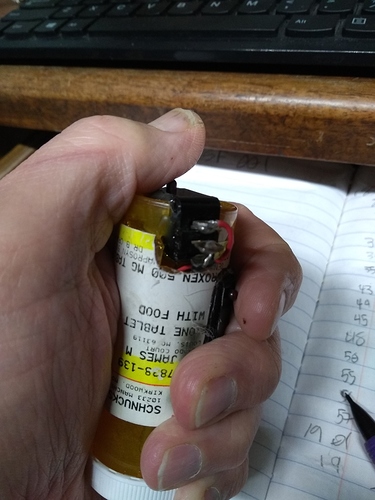
73, Jim KK0U
Andy, as a test, I blew the dust off my Palm PPK SK and found I can key it wearing a glove without errors where as I cannot key any of my iambic paddles wearing a glove. That said, using a SK again is so much effort that, in very cold weather, I’ll stick with keying my Palm Pico (with its magnetic base on a metal plate) inside my winter jacket pocket.
I’ve been out today getting some bonus points in the Lake District. Even at 700 m. I’ve been above the cloud inversion and been sending on my very tiny Russian military key without gloves sat in ythe sun!! Sending isn’t too difficult with thin gloves but picking up a pencil to do paper logging is cumbersome. I’m going to try and do some logging on my iPad tomorrow. Maybe that will be will help. I’'be got a proper keypad which I find easier to use. Thanks for all the advice guys.