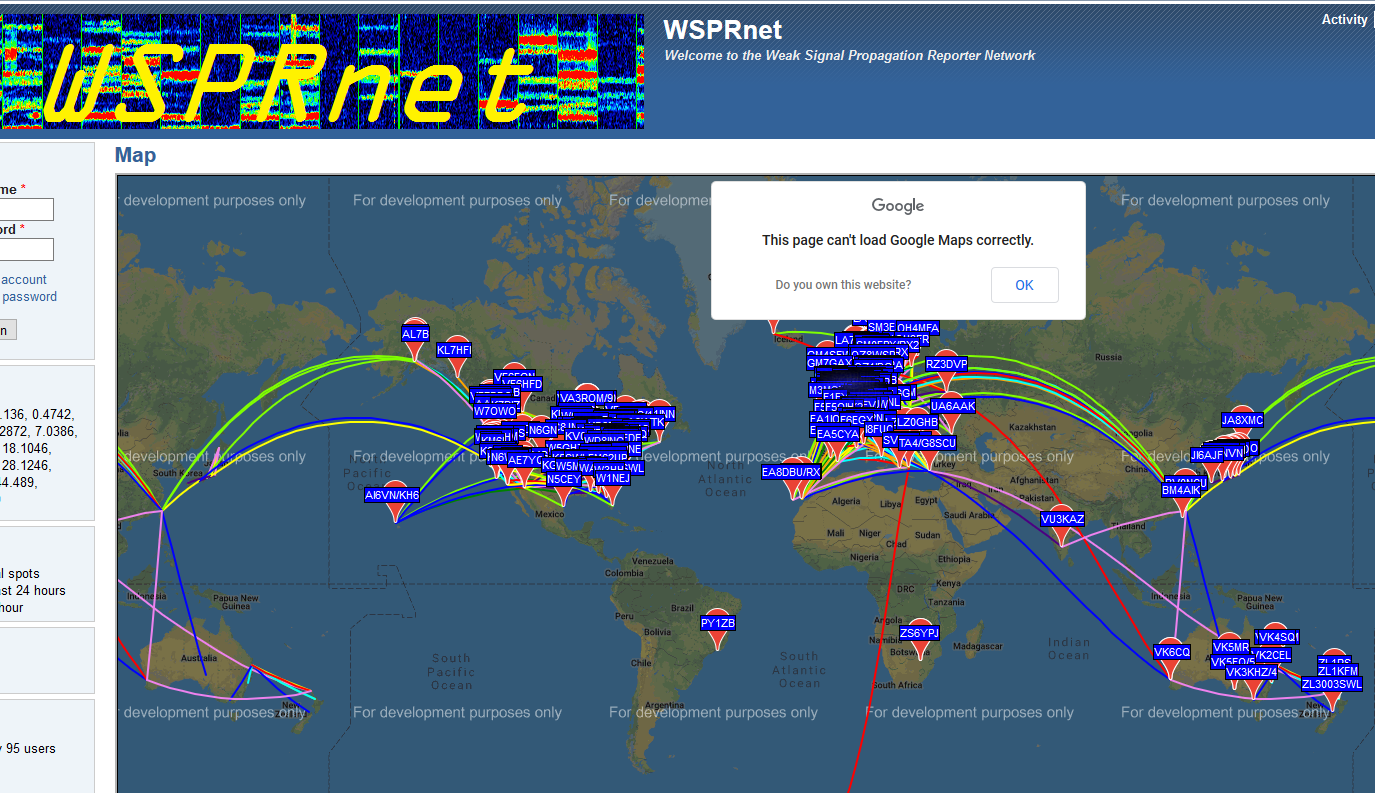
As has been pointed out to me by a few users (thanks, guys), the sotamaps site has in the last hour been displaying an error message stating that
This page can’t load Google Maps correctly
The SOTA MT and I are attempting to clear this error; in the meantime, the SMP pages ARE usable, albeit with the map area darkened and displaying a further message “For development purposes only.”
This problem also affects wsprnet and it is caused by the fact that Google Maps no longer supplies maps for free except to individuals. Several sites have already moved over to Open Street maps as their product of choice - it doesn’t have all the features of Google Maps however it is still free (and most likely will stay so).
One site that has changed is DXMaps - I beleiev qrz.com may have decided to pay for Google maps as they were also hit. Aprs.fi appears to be back to normal (the also had the problem).
Basically Google are scanning the web for usesr of their maps and disabling them as they find them.
This is a known issue - SOTA MT has a billing account with Google, which should cover such eventualities. Up until a few weeks ago, the billing account was held by me, but due to expected high usage of services, and possibly high costs to be accrued by the account, the MT took over the billing for the SMP.
At the moment, the only member of the MT AFAIK with the authority to manage the billing account is Andrew VK3ARR, who is in all likelihood asleep right now, so it may take a little while before he can attend to this. I have also notified Andy MM0FMF by PM, and it may be that he has the requisite knowledge and authority to make the necessary changes in the Google account management site.
This problem has probably arisen because Andrew may not have ticked every box in the account management site.
Basically, Ed, this is an issue which the MT and I have been discussing and moving on for several months, and whether anybody decides to use Google Maps, Leaflet or MapBox as the mapping engine, or Open Maps/OpenTopoMaps/etc. as source for mapping tiles is old news.
EDIT: One mapping site for which I (still) do have a billing account is iotamaps.org, and where I keep a very close eye on page-/map-loads, since it could work out expensive for me if the site gets too popular! And, yes, it’s running fine without any error messages.
OSM don’t provide a mapping engine, only diverse sets of map tiles: an engine is required to properly place and display the tiles at various zoom levels, and also to handle panning and zooming in the map area.
I suspect that those who have changed from the Google Maps API to use OSM tiles (and other “Open” map tiles) exclusively will likely be using something like the Leaflet engine to display the tiles. There are other mapping engines, but few are free and open-source like Leaflet.
Whatever they have done, it’s good to know that the problem on SMP appears to just be an “accounting problem”. Ripping a website apart to move to a different mapping provider must be a nightmare.
It’s even worse than a nightmare, since so much of the special functionality in the SMP is tied to particular methods of the Google API. Replacing those would involve a very major re-write. Ain’t going to happen!
Nope, Google decided to expire the credits we had until I “upgraded” my account, after which having done so they re-enabled the free credit. No email or anything sent.
All right. Expenses are mentioned here. What is the cost per map? If I search a location and then access another site to view line-of-site, and the googoogoogle maps serve a great purpose for decision making, what’s the cost?
I can imagine summer use is greater than wither and all that.
KI7MMZ
There’s no real cost per se - we’re likely to stay in the free tiers at present, but Google just decided to block our keys until we clicked on a particular button.
Lovely, thank you! This is such a valuable tool, your prompt fix is much appreciated. After you fix a tool, you might explicitly state that it’s fixed. I didn’t perceive that from your 2:23pm post. -Curt / K7ZOO
So, as everybody can see, the error messages and darkened map overlay have disappeared, and the map-types control in the upper LH corner of the map area has been restored. From this alone, one can pretty easily discern that the previous problem has been fixed. Thanks, Andrew.
As part of the drive to lower the probabilty of SOTA/MT/SMP incurring charges for the various Google services the SMP uses, we have decided to drop the Streetview control from the SMP mapping areas, effective immediately. It’s certainly a nice-to-have functionality, but it does have a significant cost per map-load or call, and its’ presence really only makes sense in a general-purpose mapping application - and the SMP is far from being a general-purpose mapping application.
As I’m sure you know Rob, in many parts of Germany Google streetview doesn’t work (or has been blocked) and as you say it’s not relevant to SMP in any case.
Well done to whoever sorted the problem and I’m glad we can use this very valuable tool again.
Yes, it’s been blocked in most places in Germany - not by Google, but by the people in the country who have decided they don’t want others peering round their streets from half a world away. It’s certainly a problem when one is trying to find a parking place on the SMP map in Germany to climb a hill…
It’s absolutely relevant! Especially when I planning non-UK activations. When I’m planning an activation I use the regional or a range view to locate summits in roughly the right area. Then I consider each summit using the Open Topo Maps view to see terrain and possible paths. Then I zoom out enough to find the nearest Streetmaps view to check for somewhere to park and also to get a feel for the area. (Busy or quiet village etc.) So for me it was very important.
HOWEVER… I fully support the decision to remove Streetmaps as a method of ensuring we don’t start running up page display costs. As soon as we enter having to pay for the mapping data then we enter a brave new world of figuring out how much of the cost of the service should be supported from SOTA funds and whether users should have to subscribe. That is something which can be done and if users need to pay for the service to remain viable then so be it. But if a simple change can massively reduce that necessity then that makes real sense to me.
What we be really cool Rob @DM1CM would be if you could click on a say a summit marker and select an “open in Google Maps” option where you get taken to Googlemaps in another browser tab with the map view centered on the summit and then you can use all the other Googlemaps options which, of course, has no cost to us. That way you could look at a summit and the topography etc. in Sotamaps and move to another tab to then be able to switch to Streetview etc. to check for parking and access etc. Don’t bust a gut if this is not trivial though Rob.
And, of course, one of those Google options - which is, incidentally, not at all available to small-time developers like us - is the fantastic Google Earth option.
Andy, you’ve probably noticed that the 4U maps are pretty good at showing the P for car parking. Thought I would mention it anyway. Like you I prefer the OT Mapping for considering terrain and a possible route and sometimes find that the 4U displays a path which isn’t shown on the OT map.
Thanks to the team for restoring this invaluable set of tools.