Trying to summarize SOTA for all the folks who ask me about it, how does this look so far, any recommendations?
SOTA Summary
Summits On The Ait (SOTA) is a game (on-going contest) where amateur radio operators operate on battery power from designated summits
Typically operators use simplex for making contacts (QSO’s), and there is no use of terrestrial (ground-based) repeaters. The only exception is satellites
Even though the operator is on battery power, they are not permitted to be in or around a vehicle. If you do a “drive-up” summit, you’ll want to be away from your vehicle (not standing next to it, etc)
To count as operating at the summit, you’ll want to be within 75’ vertical from the summit.
Making at least 1 QSO will count as an “activation” of the summit
Making at least 4 QSO’S will grant you the points assigned for the summit (points are 1,2,4,6,8,10 not including bonuses)
When making a QSO, you’lll want to use your callsign and SOTA reference number (Example: W6/SD-033).
Best practice is to note the other station’s call sign, UTC time, their signal report, and yours, and take a note of their SOTA designator if they are alson on a summit
SOTA Reference Number Example
W6/SD-033
W6 = the Association (USA - California)
SD/033 = the Summit
SD = the Region (Southern Desert)
033 = number assigned for that summit
4 Ways to Play
SWL = Short Wave Listener- listening for SOTA activators
Chaser - QSO with a SOTA activator
Activator - QSO from the SOTA reference number
Summit-to-Summit (s2s) - QSO between SOTA reference numbers
Typical Operations
Plan an expedition (pairs are safer than being alone) using SOTLAS, Google Maps, AllTrails, PeakBagger, etc
Post an Alert the night before on SOTAWatch
Ascend to the summit (withing 75’) be sure not to be in or around a vehicle, and be using battery power.
Post a Spot (or ask someone to) on SOTAWatch
Make at least 1 QSO to activate, and 4 to get the points. No terrestrial repeaters, satellite is OK.
Relax and try different bands, antennas, radios, etc
Upload your logs on SOTA Data
Post a trip report on SOTA Refelector, SOTA Summits, Facebook
Also SOTA is an ongoing activity and not a contest. You decide if you want to achieve a goal such as 100 activator or chaser points.
It was intended to combine hill walking with radio.
If you drive to your activation position then someone must be able to drive the vehicle away without affecting your operation. There is no minimum distance specified. Different summits have different constraints.
Many activators suggest parking a couple of km from the summit and walking up. Just make sure you have everything you need before setting off. Use a check list.
Great summary, thanks a milluon; I might want to adapt it to Spanish and Catalan. I’d add:
(1) chasing and S2S to Typical Operations (a different section?). In EA, some colleagues do not know they have to submit their chaser logs (they expect this to happen automatically)
(2) a link for PeakBagger?
(3) mentioning Wikiloc as another source of trail maps?
(4) add metric to US units
(5) logging software for mobile phones that generates ADIFs with the right fields for sotadata.
Cheers!
Mikel EA5IYL
When you go there, the first FAQ item you see is an exhaustive list of things to consider adding to your personal checklist, and the first thing on that list is confirming at home that your station works. I should have added “including that your batteries are charged”.
No more than 25m below the peak is a necessary but not sufficient condition, in that a neighbouring peak that is high enough may still be outside of the AZ.
Think of the AZ as an island, with the shoreline 25m below the summit peak. It’s not valid if you’re on a neighbouring island.
I’d recommend using the most accurate mapping for your area. In the US that will mean favouring USGS over any OSM-based mapping, certainly for checking contours to be confident of the AZ extent. That’s not to say other source don’t have their uses (often good for showing more paths for example), but national mapping usually trumps SRTM-derived elevation profiles by a good margin.
Also, step ‘0’ of planning is first to check the summit page - there might be some important information there.
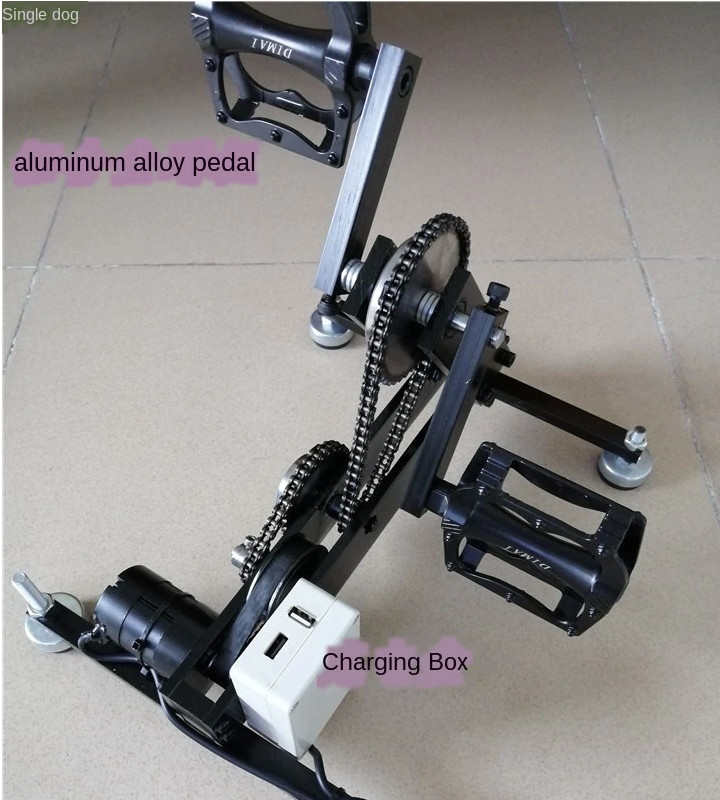
To be pedantic, the rules do not specify battery power. They just say no fossil fuel power sources. Batteries, solar and wind power all qualify. Need to avoid creating new slightly different interpretations.
For the technology in the unit it’s cheaper than a LifEPO4 battery at €66 but you would really look odd on a summit pedalling this while trying to hold a conversation on your rig!!!
Ed
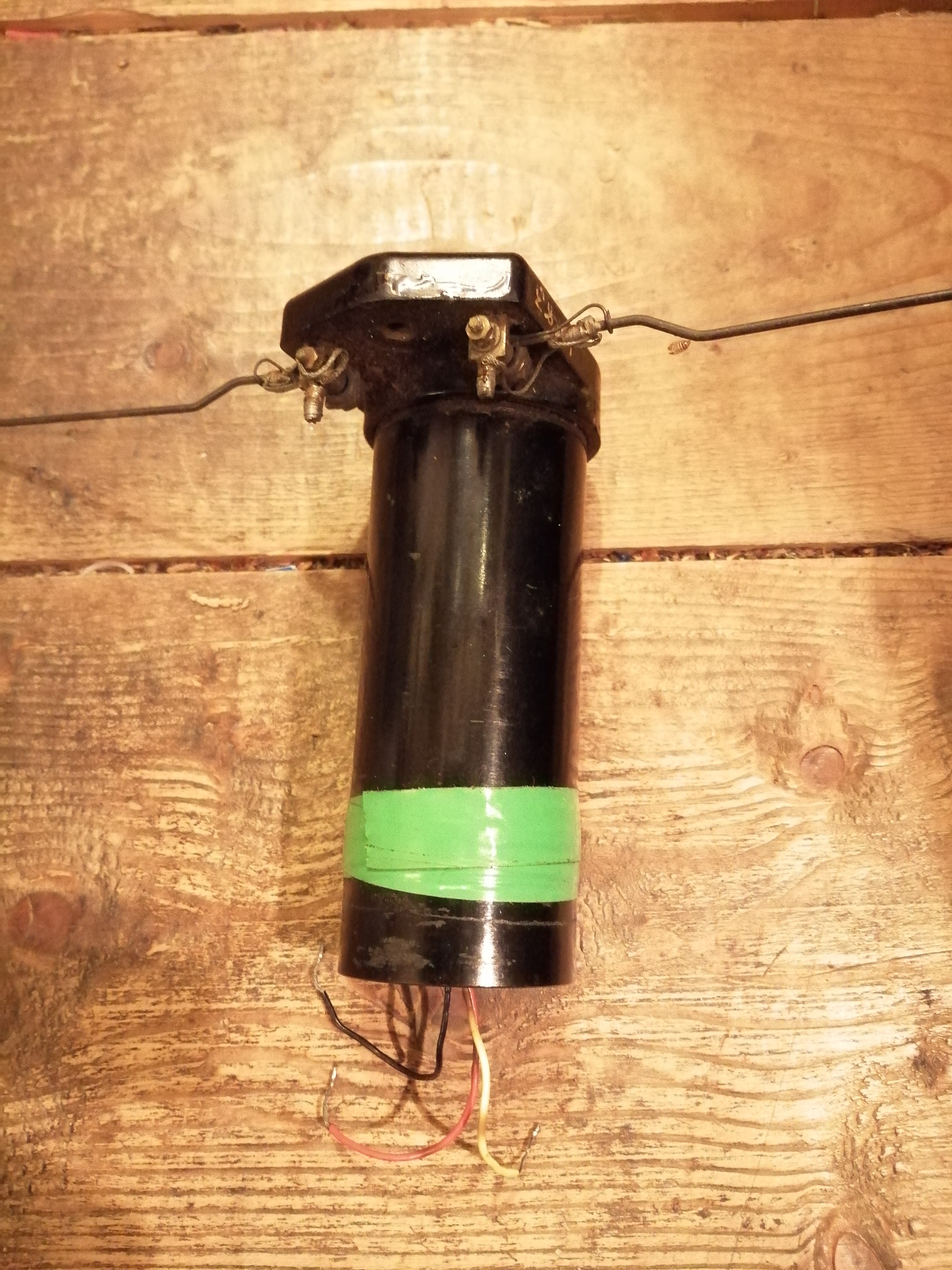
Quite a few ships carried emergency MF transceivers which were powered by handwound generators much like the foot powered one in your photograph.
Dave
Hi Dave,
Yes I know hand cranked or foot cranked generators used to be common place.
I was surprised to see them coming back.
I love this idea - a desk where the laptop in use is having it’s batteries charged by the person using it, who is also getting exercise - no need for this guy to head to the treadmill at the fitness centre at the end of the day!! Although some of the uses seem a little “Heath Robinson”.
Not powered by generator, but I have the RF end of a “Walter” beacon in my junk box. I’ve never thought of a use for it, but maybe putting a photo here justifies keeping it for 60 ish years :o)
One comment:
This is not done as much as it should be: " use your callsign and SOTA reference number (Example: W6/SD-033)."
So many contacts are the result of chasers seeing Internet spots that activators tend to assume that their chasers know which summit they are on. The exception is that for S2S contacts both parties usually exchange summit information.
Chasers should not be shy about asking “ref?” Activators should send their summit reference when calling CQ and perhaps after every half-dozen or so completed contacts.
This is more detail than is needed in the summary, of course.