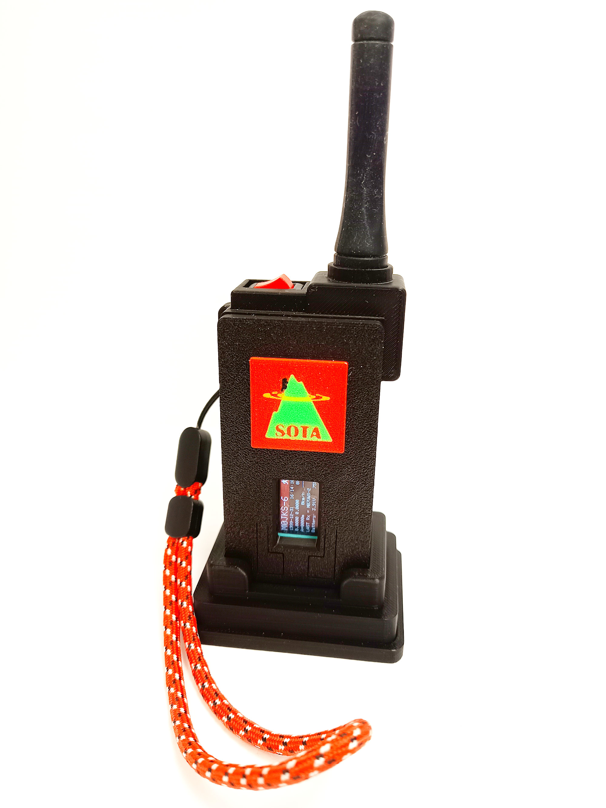
Richard, G3CWI, has done a lot of work to popularise the use of APRS trackers with many iGates now tracking activators on the hills (mainly in the NW of England). Now, M0JKS has designed a 3D printed case which incorporates the SOTA logo (thanks to back up effort from G5OLD) and is making the cases, and also fully equipped trackers, available through the SOTA webshop (www.sota-shop.co.uk) with a commission payable into SOTA funds.
3D printed case with fitted 2000 mAH battery, BMS board, switch and antenna socket with matching connector
Fully assembled tracker with a Heltec board fitted and the basic firmware flashed onto the board (there will be an option to configure the firmware with your callsign etc – but this is easy enough to do via a mobile phone browser)
Accessory pack which includes a 3D printed docking/charging station, belt clip, wrist strap and USB charging cable
The final configuration option will also allow optional transmit frequencies to be configured – this is limited to the amateur radio 70 cm band (439.9125 MHz in the UK and 433.775 MHz in Europe). If other frequencies are used in your country please advise at the time of purchase.
Finally, we must acknowledge to excellent work (and ongoing commitment) by Ricardo Guzman, CA2RXU, for the firmware that makes these boards functional as an APRS tracker
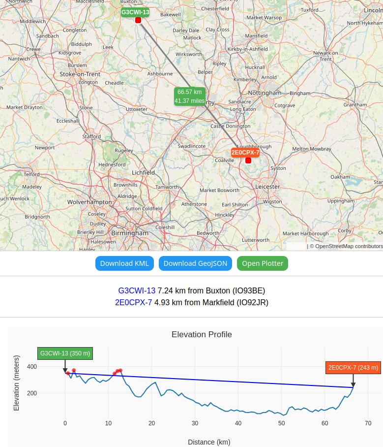
Mine arrived today, and I immediately took it out whilst taking the dog for a walk before the school run, to be honest, I wasn’t expecting much as my HT can’t hit any APRS digipeaters locally due to hills getting in the way. But at the highest point of the village, I managed to ping MB7UWS-10 which impressed me as I believe there is a a big piece of White Peak aka Blakelow Hill (367m) in the way
I went to check the mileage on APRS.fi and bizarrely it stated the distance as 301 yards! So something isn’t right as it should be saying just over 25 miles. Not peep out of a closer digipeater in Nottingham.
So apart from the mileage issue, it seems to work rather well
That’s good to hear Paul. MB7UWS-10 is located near Matlock … so not too far away from you. It also had a major upgrade over the weekend - antenna and height - to improve it’s coverage. Glad to see it’s getting into Leicestershire.
It’s a nice add to the SOTA store. I remember Richard’s wiki suggesting the RT18175 FLEXI-SMA-433 RF antenna was a great option for a tracker. I wonder how the one it comes with compares?
The bare-bones case doesn’t come with an antenna. The full tracker comes with the basic EU433 antenna that is shipped with all LF Heltec boards. A more flexible EU433 “rubber duck” antenna is included in the accessory kit along with the USB docking station, USB cable, belt clip and wristband. You can download the datasheet for this antenna (TX433-JZR-6) from here:
The case is also designed to take the RF SOLUTIONS FLEXI-SMA-433 Antenna, which can be sourced from CPC in the UK.
That looks like one of two antennas that I had with my TYT MD380 (70cm DMR and FM), I managed to lose that somewhere, however, the second antenna that came with is shorter (approx 2x the size of the antenna that came with the APRS Tracker), despite its size I know this works well as I used to be able get into the original GB3EE comfortably from the lowest part of Castle Donington which is about 33 metres ASL (111 feet), the highest part of Donington is 146M (476 ft)
Today I took the tracker up to Beacon Hill (Bardon Hill’s little brother), Unfortunately, the really interesting data like height and distance may not be accurate, as Beacon Hill is actually 248M and not 243M, so I wouldn’t trust it to work whether you were in the AZ. https://lora-aprs.live/
GPS alone is not so hot at determining altitude, so that’s well within the usually accepted margin of error. GPSr units intended for serious hikers very often include a barometric sensor to help get the altitude more accurately (assuming you’ve calibrated them on the day).
I’m not sure if I have a charging issue, when I plug it in it normally says something like 75% but after a a couple of minutes, it says something like 56% and even after more time 33%. So does this mean it is showing how much is left to charge, 0% being 100%
I’ve seen exactly the same thing during charging. Dunno what’s going on there but someone told me that the internal battery is being charged only when the tracker is turned on (via its on/off switch). If the external USB charger is not connected to the internal battery [i.e. the rocker switch is set to OFF] the internal battery voltage will decrease over time. I think you get a reliable battery reading when you unplug the tracker from the USB charger.
The switch is between the tracker board and the battery. So it must be switched on for there to be any connection during charge or discharge. However, you can shut down the tracker while charging.
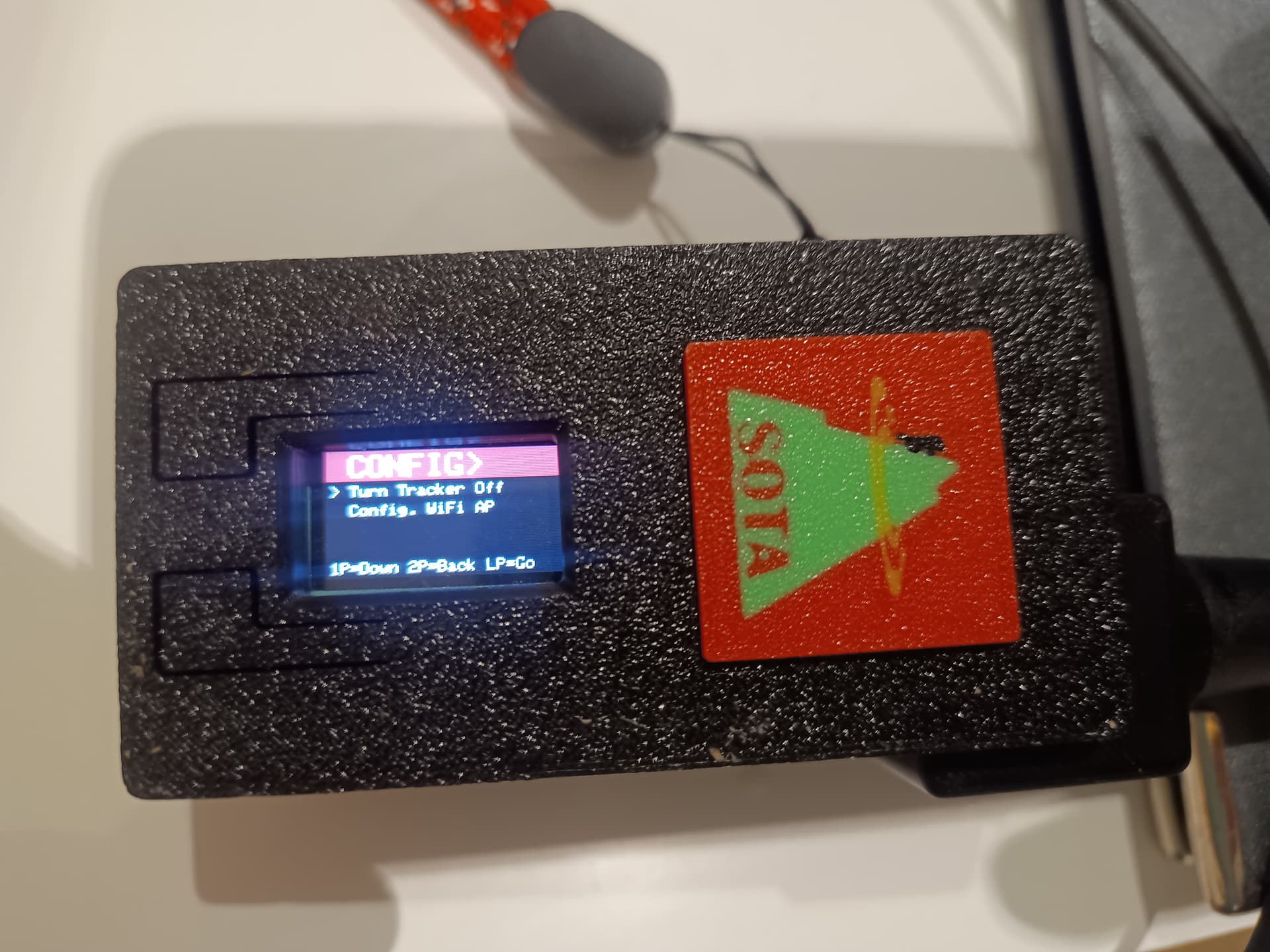
Is there some reference available describing the use of the buttons and the menus ?
The Github page does nos seem to provide information about the “two buttons” implementation.
If the configuration option was selected during checkout from the sota-shop, it will be configured with the calling and SSID requested . The default is CALLSIGN-7.
The software version installed on a full SOTA tracker is version 2024.12.21, which does allow multiple callsigns to be configured - and selected using the left hand button. This I appreciate is particularly useful in the UK when switching between secondary regional identifiers, for example M0jKS-7, MW0JKS-7 or MM0JKS-7. At the moment it is not possible to.do this through the sota-shop website, so the tracker is configured with just one. However, if people thinks this would be useful then I’ll see if the shop page can be updated to allow this. For now, if this is something someone needs, I suggest not selecting the configuration option. The tracker will then be shipped unconfigured with callsign NOCALL-10 and running the configuration web server. This can then be accessed by connecting a phone to the WiFi “NOCALL-10” and entering IP address 192.168.4.1 into a web browser. You will then be able to configure the tracker as you see fit. If you have already purchased a full tracker and need to change the calling and SSID you asked for, then triple press the left hand button and then select “Config WiFi AP”. The unit will then reboot in WiFi configuration mode as described above.
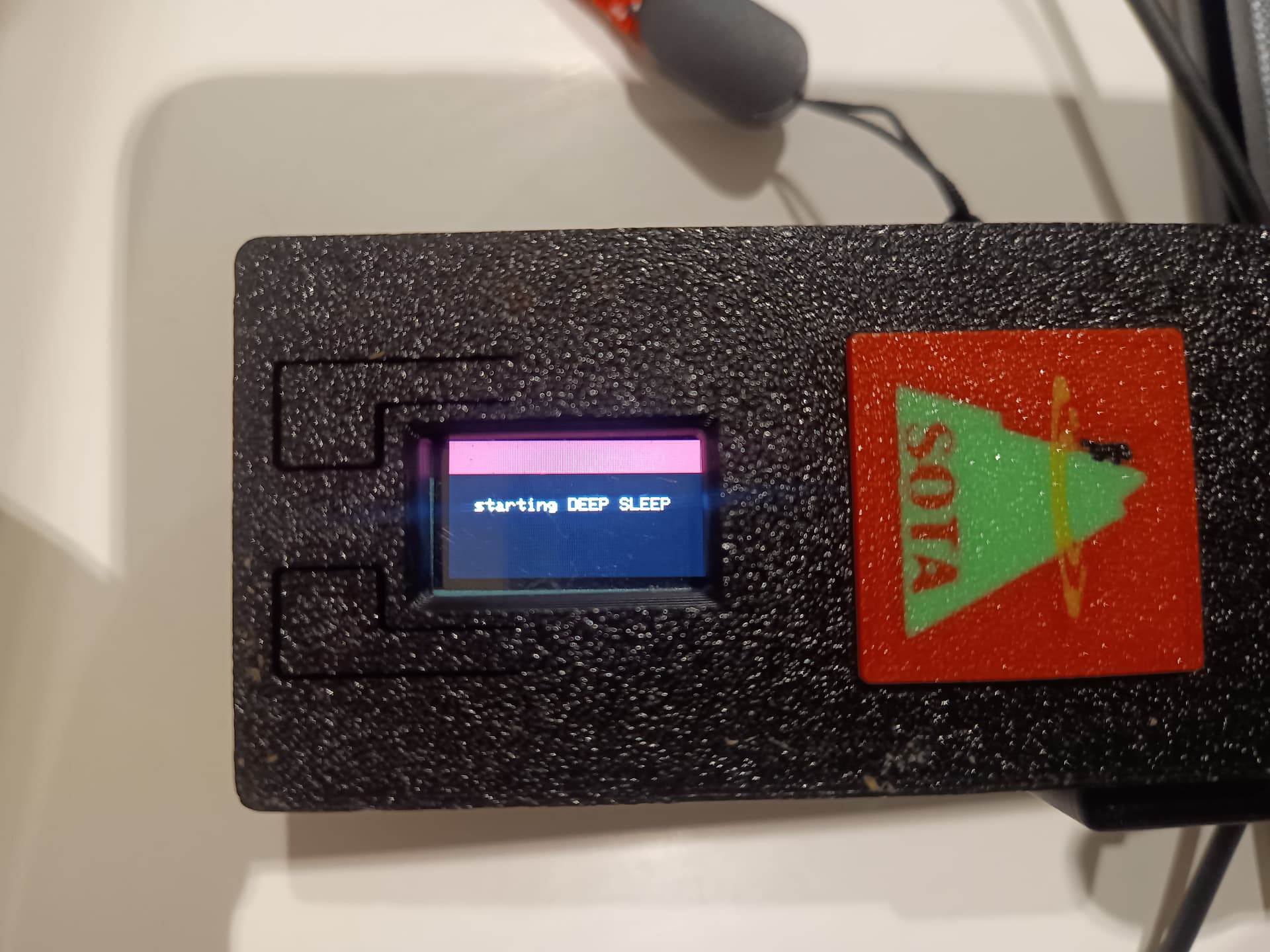
As other have noted, the red switch on top of the tracker simply disconnect the 3.7v LiPo battery from the JST 1.25mm battery connector on the rear of the Heltec Wireless Tracker board. When the tracker needs to be charged (USB plugged in), the switch needs to be turned ON so that the TP4054 charger IC on the Heltec Wireless tracker board can charge the battery. This is also why the % battery charger level is misleading during charging, because the A/D on the ESP32 which measures the battery voltage is actually measuring the charge voltage of the TP4054 during the constant current and constant voltage phases of charging. If you would like to turn off the Tracker off during charging, simply press the left hand button three times so it displays the following