There a a couple of updates and enhancements to sotamaps which may prove useful to some of its’ users.
New map types added
Firstly, two [EDIT: three new types: see below…] more map types have been added to all mapping pages, to bring the total of mapping types available to six [seven] in total. Previous versions of the SMP have included the following:
the “Map” and “Satellite” mapping types as standard from Google;
Open Street Maps (now activated by the “OSM” button);
Open Cycle Maps (now activated by the “OC” button).
The new mapping types are:
OpenTopoMaps, activated by the “OT” button, and
4UMaps, activated by the “4U” button.
These have now been joined by a third new type, CalTopo maps for the USA, activated by the “CT” button.
Each of these offer excellent views of topographical information and contour lines, especially at higher zoom levels, and users may appreciate one or the other as an alternative to the others listed above.
Display all tracks in a SOTA region
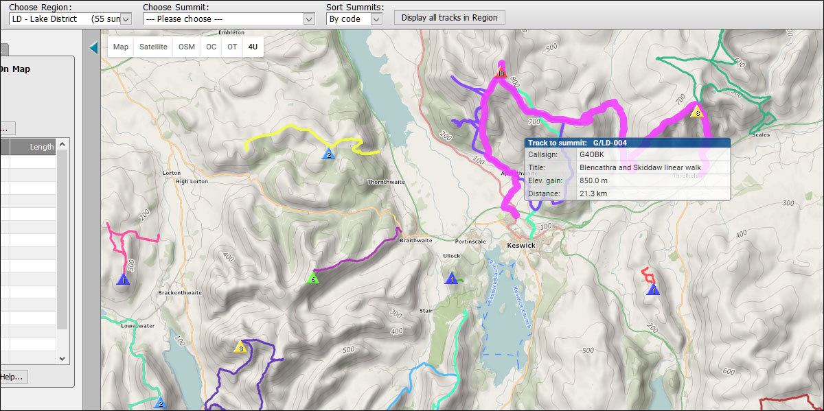
The second update is to the SMP tracks page, and allows the user to display ALL available user-uploaded tracks in a SOTA region. After choosing an association and region from the main dropdown controls near the top of the page, the user can then activate the “Display all tracks in Region” button to show those tracks in the map. Here a screenshot of what that might look like, on a 4UMaps background:
By moving the mouse cursor over the map, any one of the tracks in the map can be highlighted - as in the example graphic - and, by clicking on the highlighted track, the display will change to show just those tracks leading to the summit associated with the highlighted track. Track colours are randomly chosen, and do not indicate track difficulty, or length.
This new feature gives perhaps a better overview of the tracks available in any particular region, as well as an indication of the amount of activity that has taken place in that region.
To avoid confusion in the UK where ‘OS’ is commonly used to mean “Ordnance Survey” could you change it’s button to read ‘OSM’ which is the more common abbreviation for “Open Street Map”.
Hi Colin, that’s now been changed - you may have to refresh the browser to load the change. I was trying to save as much space on the screen as possible to avoid the different sets of map controls from overlapping when the user’s screen was set to a narrow width.
BTW, I’d really like to be able to offer Ordnance Survey mapping as an alternative for UK users, but it’s not available for free as a replacement mapping type…
great that it is now possible to view all the tracks available of a region. thank you for that!!
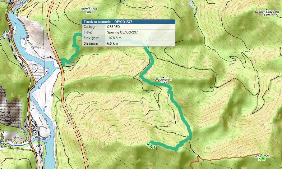
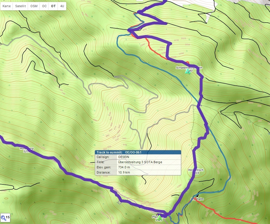
i had a look at my local region OE/OO and noticed that also all previous uploaded tracks to summits that have been deleted in 2016 (or earlier) are shown. on the screenshot you see tracks to OE/OO-061, OE/OO-282, OE/OO-237 which have all been deleted in the past!
Yes, this has now been implemented - use the “CT” (CalTopo) button to activate the CalTopo map type. You’ll probably need to refresh your browser (F5 or Ctrl+F5) when viewing a SMP mapping page to load the new functionality.
So, a small update to the range and tracks pages. As some may have noticed in the ON7DQ Mallorca Trip thread (or just by using the main page), the SMP main page now features small labels next to the summit markers: the labels show the summit code, making it easier to identify individual summits in a large group.
This functionality has now been ported to the range and tracks pages. Further details about these labels can be found in the link above.
Feature request: Ability to reverse the order of an uploaded .gpx file. (or more obvious method if this function exists already)
Example: I recently activated Eagle Bluff (W9/WI-040), which requires a bit of bushwhacking. A GPS track of me wandering through the woods would be of little use to future activators, so I recorded a track of my decent using the best route that I found. I then found a site online (made for bike enthusuests) that allowed me to upload my track, reverse the order, and download the new track. This generated the proper ascent route for this summit.
The new map backgrounds are fantastic. They have shown some access to a few summits I assumed were inaccessible. I’ve started posting some tracks as well, so hopefully people can enjoy having those.
I use GPS-Track-Analyse.NET for editing the gps tracks prior to loading them into SMP. Editing means cutting out side-trips, spots where you took a rest or any erratic points that show up when GPS signals get reflected. This software has an option to reverse the track. I assume other editing software would also have this feature.
In general I think that the original hiking direction should be maintained in a track. This is valuable information and there are routes that are better suited to ascend than descend and vice versa. You discovered the best ascent late in the day. Why not comment your track “This was my descent which is also recommended to ascend”
I reversed the track because the SMP help page says the uploaded tracks should only show portions of the trip that are under human power, and should only show the ascent. The reasons given for this are to assist future users in navigation, as well as enhance the presentation of the track (proper elevation profile, for example).
Leaving the track as a decent route would also require future users who wish to use the track to aid in their ascent to find a way to reverse the track themselves. May be trivial for some, but others may not immediately know how to accomplish this. Plus, it’s usually better for one person to do the work once than many people to do the work several times.
While an ability to fully edit .gpx files within SMP would be a great feature, I’m sure that would take more time and effort to implement. A simple “reverse track” button would be useful for instances such as the example above, or for times when an activator may forget to enable logging before ascent but may still be able to record a decent.
In the end, it’s up to Rob what he wants to put his time into, and there are 3rd party methods of editing .gpx files as it is. I figured it would be useful to bring it up on the reflector to gauge interest.
I wouldn’t worry too much about it if I were you - quite a few users have uploaded tracks which record the descent only. There are still those (and you know who you are ) who upload tracks with both ascent and descent, where the ascent and descent portions follow the exact same line: these are the people who either refuse to read the help, or are too lazy to follow it if they do. Fortunately, I have tools to edit out “bad” sections of routes.
As it happens, I did build some track-editing tools into the SMP tracks page last year, but got distracted by other, more pressing issues. Perhaps I should finish that task? At any rate, as others here have pointed out, several options for editing .GPX files exist out there, so it shouldn’t be too difficult to find one which suits your purposes and pocket…
Rob has there been a mapping update? I keep getting an error alert “ReferenceError: enableZoomOnFuzzyBorderDblClick is not defined”. This is on Firefox 53.x, Win7-64.
Select OM/BA with all the layers active. Zoom out a little and double click a neighbouring region rectangle , say OM/TT. I get a wait cursor followed by the map greying and the error box. Click OK and I get another error box. Click OK and the summit markers for the new regions are drawn but there are no region borders etc. shown. If I select a new region from the drop down menu then everything looks fine until I double click another region rectangle.
Everything else seems to be working fine… planning some Central Europe bagging for this October.


 ) who upload tracks with both ascent and descent, where the ascent and descent portions follow the exact same line: these are the people who either refuse to read the help, or are too lazy to follow it if they do. Fortunately, I have tools to edit out “bad” sections of routes.