Just published a couple of small updates to the SMP range page.
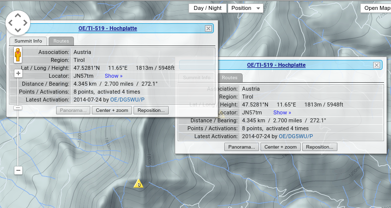
It’s always bothered me that, when choosing a summit from an in-range group of summits, the popup info window can sometimes obscure various portions of the map which may be of particular interest - these could be:
general areas of the map,
routes which may be displayed,
panorama viewpoint graphic, and so on…
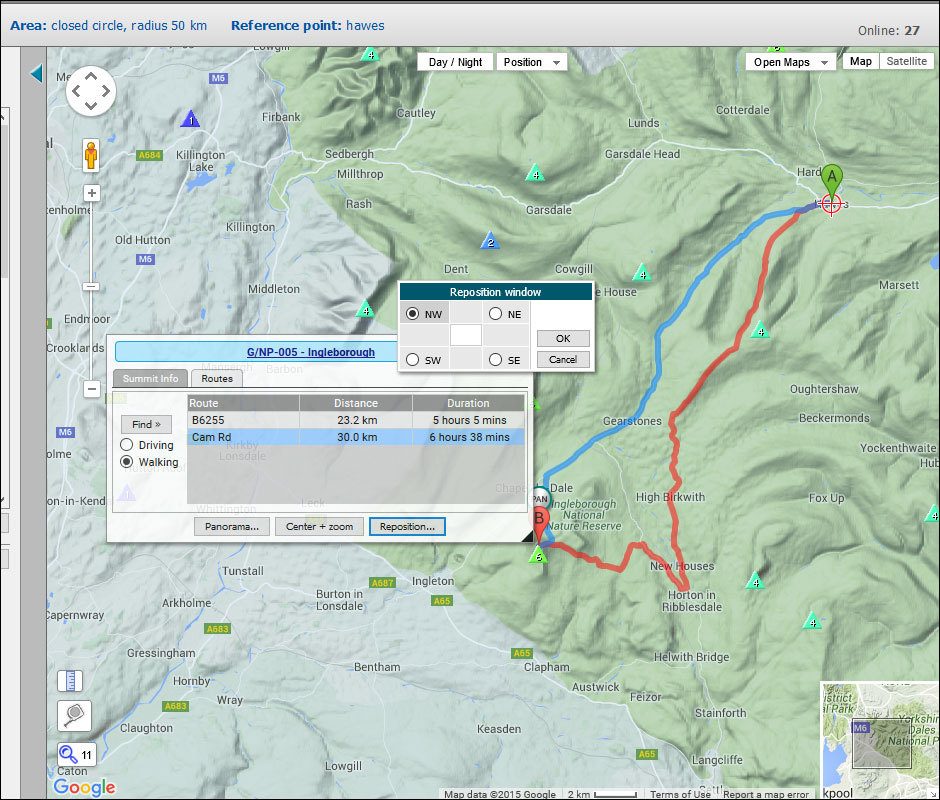
To alleviate this, it’s now possible to reposition the summit info window - click on the “Reposition…” button to show a dialog where the new position may be set to avoid such areas.
In addition, two types of route may now be chosen:
driving routes,
walking routes
between the reference point and the chosen summit. These two types of route can sometimes overlap, or follow the same road, for some considerable distance before separating. I’m working on a solution to color these differently so one might distinguish road sections from strictly walking sections.
Thanks Rob,
Nice update with being able to move the info-box. I often take a screenshot from SMP and often the info box obscures some detail. I can now move it to a different part of the screen, still have the info included but also have a clear view of the summit area.
very nice features. Especially, if you hover with the mouse over one of the found routes only this one is displayed. This IMHO helps very much.
Sometimes the Google routing algo seems to find also driving routes which are not on public roads, so you shouldn’t rely in all cases on the found routes. It is the same with all the car navis, if you switch them on, first of all they show a big warning messsage “Don’t trust me”
Just another hint, in my browser, I cannot close the dialog anymore by clicking on the cross in the upper right corner. And if I click on the summit reference in the header of the dialog, only the following URL will be opened (of course with a error message) “Hiking in the mountains: tips for beginner hikers - Mountain Day”. Maybe it’s some kind of minor collateral damage
[quote=“DM1LE, post:3, topic:11918”]
Sometimes the Google routing algo seems to find also driving routes which are not on public roads, so you shouldn’t rely in all cases on the found routes…
[/quote]Aahhh, the Google routing algorithm… Google is your friend
[quote=“DM1LE, post:3, topic:11918”]
It is the same with all the car navis…
[/quote]…I wouldn’t know, since I do not possess such a thing!
[quote=“DM1LE, post:3, topic:11918”]
I cannot close the dialog anymore by clicking on the cross in the upper right corner
[/quote]…works for me!
[quote=“DM1LE, post:3, topic:11918”]
the summit reference in the header of the dialog,
[/quote]—that was me! The dialog is a new one, built “on the fly” on the server each time it’s called and delivered to the browser via Ajax: I thought I had everything covered, but I missed that one. Fixed now, thanks as ever for the heads-up; you too, Ed !
It would seem people in Germany like this kind of thing…
now all works perfect! The links in the header of the dialogs refer to the correct summit pages again and I cannot even reproduce that closing the dialogs by clicking on the cross doesn’t work any more.
Maybe today I’ve some extra clumsy fingers, because now I got a display like that:
This does illustrate nicely how the VK1 summits are 1 pointers among their nearby similar height VK2 summits which are referenced to the wider VK2 landscape and have higher points…
Hi Ed, I fully intend to port it over to the other pages, so it’ll take a day or two… Right now, I’m at my part-time workplace where I pack screws, bolts and fasteners for shipment - it keeps me in pocket money
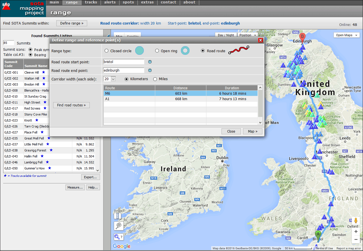
Another update to the range page. For those of you who like to (or have to!) take long road journeys, it is now possible to get a listing of SOTA summits within a given distance along the route you take.
In the “Define range…” dialog do the following:
choose “Road route” as range type;
enter your start- and end-points (these will be towns or cities);
choose a “corridor width” within which the summits should lie;
activate the “Find road routes »” button to start the search for available road routes;
choose a road route from the list;
activate the “Map »” button to start the search for summits within your defined range.
If all goes well, you should be rewarded with something like the following screenshot:
Often, multiple routes are found between your start- and end-points: in this case, you can choose the one you want from the list, and hit the “Map »” button to load the summits along the new route.
This is still a “beta” version, having just been written, and so there will probably be a bug or two in the works, but they should be ironed out in the next couple of days.
Hi Rob, that is an excellent addition to the site - and would be so useful for planning purposes during trips. What I would like is to be able to work out which summits are drive to summits versus those that need significant effort (read time) time to get to. I do some longish drives at times (7 hours or so) and it would be great to be able to pick the summits that add the least time to a long trip.
I realise there is currently no field in the database which records if a summit is drive on or not, so this would need to have a field added that would be need to be editable by activators. Thinking maybe categorise them along the lines of “no vehicle access”, “4WD accessible” and “2WD accessible” and maybe a free text field for comments or links to blogs/activation reports.
OK, who better to do this than yourself? Do the research, get some mates to help out, and build some kind of database/spreadsheet/table online for others to view.
[quote=“VK1MA, post:16, topic:11918”]
this would need to have a field added [in the SOTA system] that would be need to be editable by activators
[/quote]I’ll bet my last pension check this won’t happen. Period.
IMHO, there’s too much reliance on the SOTA MT to provide the users with fancy bells and whistles, when the MT only just have enough time and energy to do SOTA and database admin. So let them do the tedious, mundane stuff , while the users can collectively and proactively create the sparkly stuff .
Hi Rob, completely agree that an awful lot is asked of the MT - and incredibly they manage to achieve a large proportion of this.
I am semi computer literate - better than some, worse than others, but I have no experience in the creation, maintenance, administration of or signifant interaction with databases (excluding inputting some information as a semi privileged used in some instances).
I too doubt that the MT would be likely to go ahead with this proposal as quite frankly they already have a vast number of higher priority items to address. But, with my limited knowledge of databases, I would have expected that you would have your own which are populated from the SotaWatch databases, making yours an ideal starting point. Personally I am more than happy to input my own knowledge, but this would by virtue of the scale of things require it to be a collaberative piece of work - there are only so many summits that I have knowledge of.
I guess it comes down to how many people would a. find this concept of use and b. would be willing to participate in this - hence my proposing this as a possibility. If nobody else thinks it would be handy, then it goes nowhere! If it has significant support and the MT believe the effort to action it is justified then we may see the addition of another couple of fields in the SotaWatch database - maybe, maybe not.
There are a number of areas that would need to be looked at including oversight, accuracy and who would be able to add this information to a database (Association Managers only, logged in SotaWatch users, general public, etc), but that is getting too far ahead of ourselves.
There is already the facility for people to submit resources (some of which contain, directions, parking and other information) which are shown under the summit information pages on Sotawatch, however adding new resources is currently suspended whilst work is on-going with the new web site.
On the top of the left part of the screen, where the summits list is displayed, you now have a “radio button” labelled “Activation count”. When selected, the map shows circles instead of triangles, and their diameter varies according to the number of activations.
For regions where many summits have already been activated, this is a very good hint about the difficulty to reach them.
In regions where there are few activations, like W6, it is more complicated.
When we were compiling the big W6 expansion, I tried to list peaks that were accessible, especially for people with disbilities. But that is tricky. Is that road on the map OK for a wheelchair van? You can park close to the summit, but is the parking lot inside the activation zone? Is the trail to summit accessible, and how: crutches, wheelchair?
And then there is Four Wheel Bob.
Also, consider access rights. We have a local summit (El Toro, W6/NC-376) which is only open one day each year. Mt. Umumhum is a drive-up within an open space district, but only accessible with permission from the landowners down-slope. Someone maintaining a ham repeater on the peak could activate it. But next year, it will be open to everyone.

 !
!