Not sure if this is the place to put it, but the map doesnt seem to be working for me tonight. I went to my association, W4G, and get a window saying there are no records to show. It was working fine earlier today.
Well actually, I noticed that often when you MouseOver one of the mountains on the map, it didnt give you the option to click it, That was a minor inconvenience. Now I see nothing.
Thanks so much for keeping this tool going. It is awesome.
Yep, this is my bad. I completely misread an email from Rob and cast aspersions on the operation of SMP. The iotamaps server was hosting the data and that server is moving, requiring us to re-evaluate the usage of the tool
Not “just something simple”, but if you have a fast processor, enough memory and patience, you can try “ALL SOTA summits shown on Google Earth” from ON6ZQ | www.on6zq.be
When the full list is loaded, do not try to move the globe yet, but deselect “ALL” from the left menu and only re-select the Associations you want to see.
You can of course also select individual Associations .kml files that load much faster.
You’ve inspired me to spend some of my lazy Sunday to try to come up with a world-wide SOTA summit map that shows all the summits at once, and can be zoomed nearly without delay on a reasonably modern computer/browser:
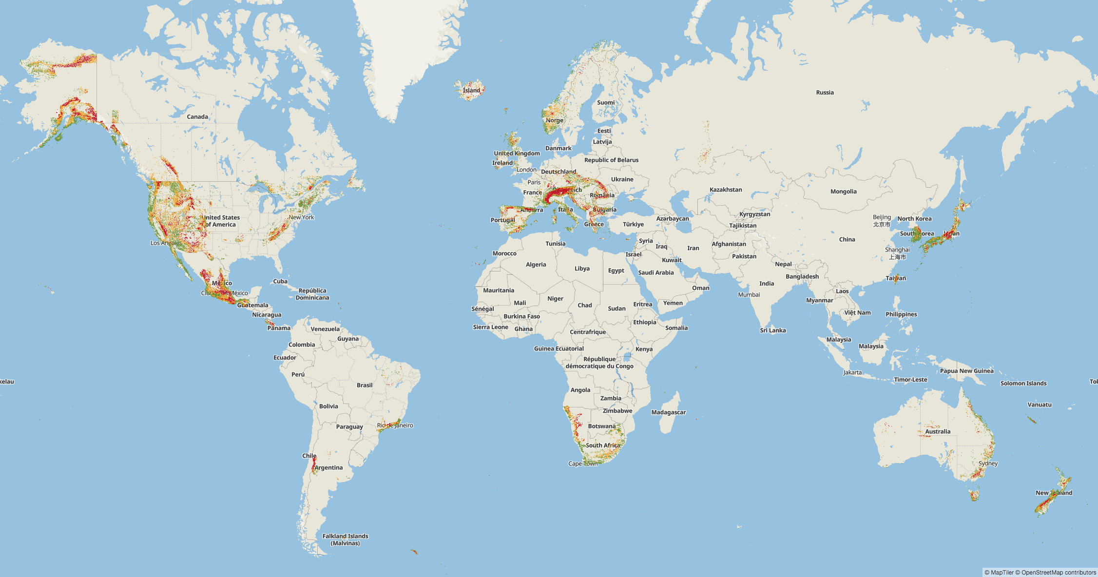
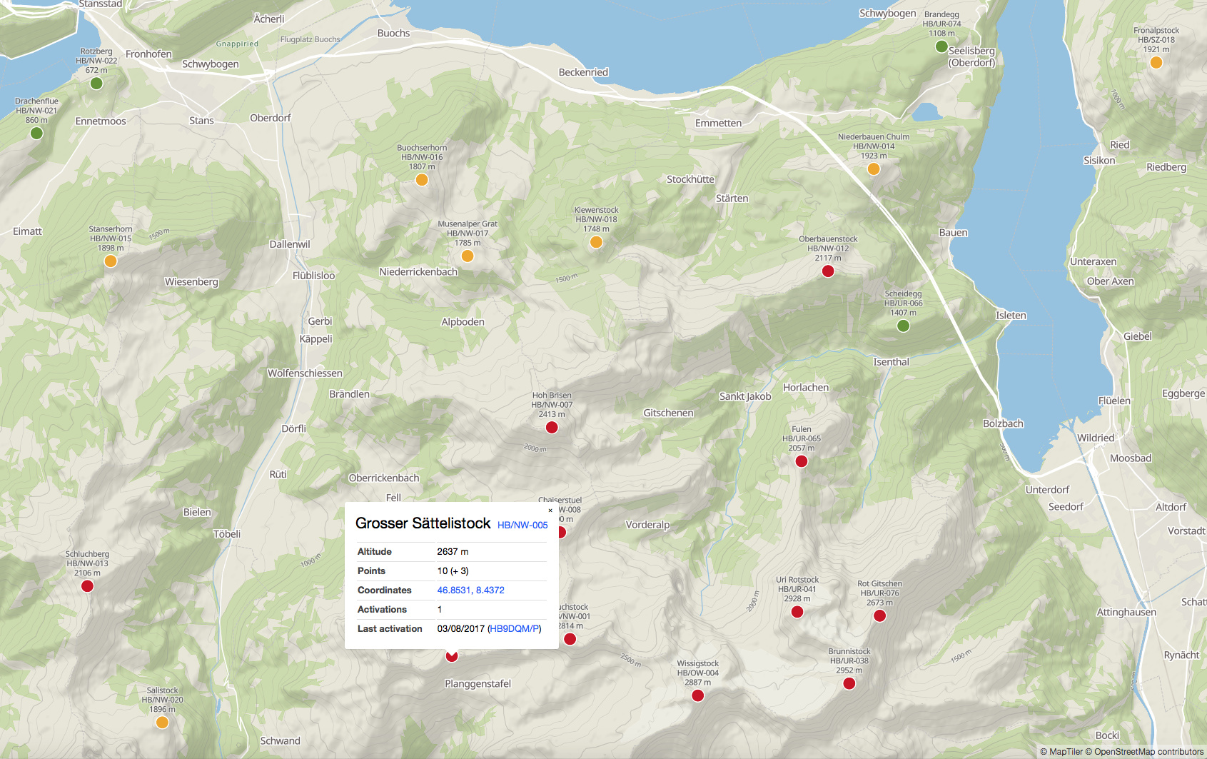
It was just quickly cobbled together, so there are currently no filter options and no further features besides getting a detail popup when you click on a summit. But it shows what could be done…
As I was checking out a summit on the SOTA Database for the W7A Association, I saw that a track existed. However when I went to the Mapping section for Tracks and entered in the Region, I got a pop-up that said: “Summits-No Records Match Your Request.” I went back and selected some different Regions where I knew for sure there were tracks and got the same message.
Any news on the future of the elevation feature? Does the iotamaps server still has the elevation data service?
Sylvia @OE5YYN was also missing the feature just recently.
I know that there are other issues with the SMP but please don’t abandon the elevation profile tool. Thanks.
Nice map system. Interesting that if you go back with the browser it goes to the last summit you clicked on, but expanded so that it’s centred on the screen in a close-in picture rather than the multiple summits that you saw the first time when you clicked on it!
I haven’t found how to select just 1 or 2 or 3 associations with it yet though - e.g. the DL and OE associations merge into one big collection of red (10 point) dots at the border.
In any case each to their own. It’s nice to have choice and for planning a long distance trip, this neon1 map could be very useful when multiple countries are involved.
New version just uploaded, with filtering and more view options (try the buttons in the top left corner of the map). Summit photos are also pulled automatically from Wikipedia if available, and shown in the summit details popup.
I’ll temporarily be bringing down the SMP server while I take a snapshot in preparation for fixing the sync problems and the elevation data. Should be down for about 30 minutes.