After my Yorshire Dales cycle tour last month I was left with six G/NP summits remaining. Three of the remaining summits are located in Swaledale, and a further three spread over the North Pennine AONB and includes Mickle Fell.
Mickle Fell is part of a military firing range and requires a permit for access; usually available on around a dozen weekends per year. I obtained a permit for 3 May, and decided to tick-off the three North Pennine AONB summits in a one-night cycle tour.
The plan was to start at Carlisle on 2 May, and cycle across towards the village of Talkin, ready to ascend Cold Fell (G/NP-020) on foot. On would then cycle down the western fringe of the Pennines, and activate Dufton Pike (G/NP-027), before heading up onto the Brough-Middleton road where I would camp. Mickle Fell (G/NP-002) would then be activated the following morning.
I set out early on Friday 2 May, getting to Carlisle by train, and then across to towards Talking village. The minor rood then took me up a steep climb and around to the hamlet of Forest Head where I locked my bicycle to a fence. Despite setting off from home at about 0600, it was already around 1015 when I reached this point. I had considered setting off the previous night, with a plan to camp in this area before setting off for the summit. However, despite being on the fringes of Access Land, the area felt quite intensively farmed, I think I would have struggled to find somewhere to camp that was easily accessible with my road bike.
The weather was really quite warm, with blue skies and bright sunshine, we were in the midst of a Spring heatwave. I changed into walking mode, swapping my cycle shoes for trail shoes, and slapping plenty of sunscreen over my face. After double checking I had packed my radio in my day sack I headed up the hill.
I broad gravel track carried me tot he foot of the main climb, from where a well worn grassy trail climbed up to the moorland. After around 250m of steady ascent the gradient eases and the route passes over heather moorland to the summit. On such a clear day this is a wonderful location, being at the northern end of the Pennines. Looking to the south I could see Cross Fell in the distance, to the east the South Tyne Valley leading towards Alston. In the north was Northumberland and the Wark Forest. The Northwest Scotland and the hills of Eskdale Muir and Galloway. Off to the west the Lake District sat of the horizon.

Almost there - approaching the summit

Summit of Cold Fell
The summit cairn was nice and large, and provided a shelter from the brisk breeze. I quickly setup for VHF, using an RH77) atop my FT70 (much better than the FT5D in bright sunlight). First contact was with M0LLC and then M0ANU/M followed by G4WGA/A in Carlisle and M0XUP in West Cumbria. I then heard GM5ALX/P calling from Glas Maol (GM/ES-012) Just North East of the Spittal of Glenshee, and managed to make a contact, I was very pleased to work so far north, GM5ALX/P was using a Yagi antenna.
With five contacts made and a long day ahead, I decided to head back to my bicycle and start the ride south. As I left the summit I looked towards Cross Fell in the distance and contemplated on the fact that my intended camping spot lay somewhere on the opposite side – it looked a long way.
I was back at my bicycle by around 12:30 and changed back into cycling mode. Having entered the afternoon already, I decided I had two choices. First option was that I could could cycle all the way to my planned camping spot and omit Dufton Pike, with the possibility of cycling to Dufton Pike after Mickle Fell. My second option was to hop on the Settle-Carlisle line for a couple of stops in order to cut out a couple of hours of cycling. The second option would give my time to activate Dufton Pike.
I chose to cheat and use the second option, so that I could be sure of activating Dufton Pike. So I set off to cycle to Lazonby & Kirkoswald (about 16 miles from this location) at about 1300hrs. This was a great choice as not only would it cut out 2 hours of cycling, but since the train was not due until about 3pm so I would get an hour to rest at the station and eat some lunch.
The cycle ride to Lazonby was good fun, this is a loverly and overlooked part of the county of Cumbria. At Lazonby I stocked up on provisions for a hearty picnic on the station platform. A stone-built waiting room provided a cool place to sit for an hour and take some food.
The four-carriage 158 bound for Leeds from Carlisle trundled into the station, where I was the only passenger waiting, The train took me through Langwathby and onto Appleby - only around a 20 minute journey. Dufton pike loomed into view as we approached Appleby at 1532.

Water stop in Appelby
I cycled out of Appleby, gradually gaining height to reach the village of Dufton, where I headed along a stone-chip surface track. The track was a but rough for my road bike, but I cycled as far as I could before changing into walking mode.
It was now late afternoon, after 1600hrs, as a I set off along the Pennine way. A kissing gate marks the start of the route up Dufton Pike, the gate was a very tight squeeze even after taking off my pack, I imagine some people might find it quite a struggle.

Approaching Dufon Pike
I headed briskly of the grassy slope to reach the summit at 1640. After munching on some food and drink I setup for a 2m FM activation. The thought of heading back into Appleby for some fish-and-chips was quite strong in my mind, so I was hoping I could keep this activation quick and not need to setup for HF.
First in the log was G8KBH followed by G6AEK. I had a chat with G6AEK about my plans for Mickle Fell, he indicated that he would drive out towards Kirkby Stephen to guarantee getting the chase on this relatively rarely activated fell. Next in the log was G6LKB, MM1DUy and finally G4WHA/M.

Easy activation on 2m FM

Delicious cinnamon bun!

Back at my bicycle
Dufton Pike had turned out to be an easy activation, I had thought its low lying summit would be more difficult to qualify. I could now head off to Appleby for fish-and-chips. I closed down my station at about 1700hrs, had a quick bite on a cinnamon bun (not too much though, else I might not get back out of the kissing gate) and headed back to my cycle.
By 1800hrs I was sat by the river in Appleby eating fish-and-chips with a can of Vimto, feeding the ducks, and watching an evening cricket match.

Ducks

Joining the A66

Same bike, same location, in 2009
Fully restored with a good meal, and with the evening getting cooler I set off for the final leg of the day. I cycled out of Appleby and joined the A66 at just before 1900hr, heading towards Brough. The road passes the main Warcop Training HQ, complete with signs warning of tanks crossing the road.
Arriving in Brough at about 1920 I bought three 750ml bottles of Lucazade from the local shop and a couple of family sized bags of Jelly Babies – just in case I needed a kick to get up the steep hill that was approaching.

Brough village
Leaving brough on the B6276 the road climbs steadily from an elevation of 200m in Brough to a spot height of 480m, it doesn’t sound much, but after a long day I was very glad I had not attempted to cycle all the way as well as activate Dufton Pike. Instead of climbing the hill at about 1930hrs in the evening light, it would have been 2130hrs (or probably much later).
In summit the pass, I cycled up to the start point for tomorrows ascent, marked by a series of warning signs and a danger-area flag. This is a wonderful road to cycle, and I recalled passing this way around 15 years previously in torrential rain, when I had taken a photo of the flag, tonight the weather was much better.


Arriving at dusk
Warcop training area covers around 24000 acres, about half of it is owned by MoD and the remainder is leased from the landowner. The range was first used in 1942 as a tank gunnery range in order to prepare for the invasion of Europe. The range is heavily used for a board number of functions from artillery training to infantry training.
I found a glorious camping spot. Not only had the grass had been nibbled into green velvet by rabbits, but some grassy hills around it provided shelter from the wind. It really was perfect.

Lovely camping spot
After a pleasant nights sleep I took down my tent at 1900hrs and readied for the walk up to Mickle Fell. Following the required procedure, I 'phoned that guardroom at Warcop and informed them I was activating my permit, and about to start to the ascent. I was asked to state a planned finish time and to provide the location/registration of my car: the guard instead took details of my cycle.

Starting off on the route to Mickle Fell
The weather was overcast, and damp as I left the road and began heading NNW along the Cumbria/County Durham boundary, The route first climbs about 100m before dropping down to Coonypot beck, After around 1200m of walking I passed a further warning sign, that marks that actual boundary of the danger area and the start of the firing range.

Start of danger area
The road turns NW, still following the county boundary and proceeding for around 3 orr 4km. This is typical heather moorland, but I found it to be crossed by several lovely little streams. I passed several camping spots; unfortunately, such activities are not allowed. Indeed, the terms of access restrict walkers to daylight only.
To the north, the main bulk of Mickle fell lay. It is an interesting hill, with a steep escarpment on the south face and a trig point that is couple of kilometers to the east of the true summit.

Plenty of interest on the walk - lots of little streams

Final climb to the summit ahead
Soon enough I turned north and had the end point in my sights, a steep grassy climb took my up the summit ridge. It was now 0900hrs, my alerted activation time. I called out on 145.500 FM for G6AEK, and he quickly responded, I let him know I would be another 10 minutes or so before starting my activation (although, looking at the map later, I realise I was probably already within the activation zone).
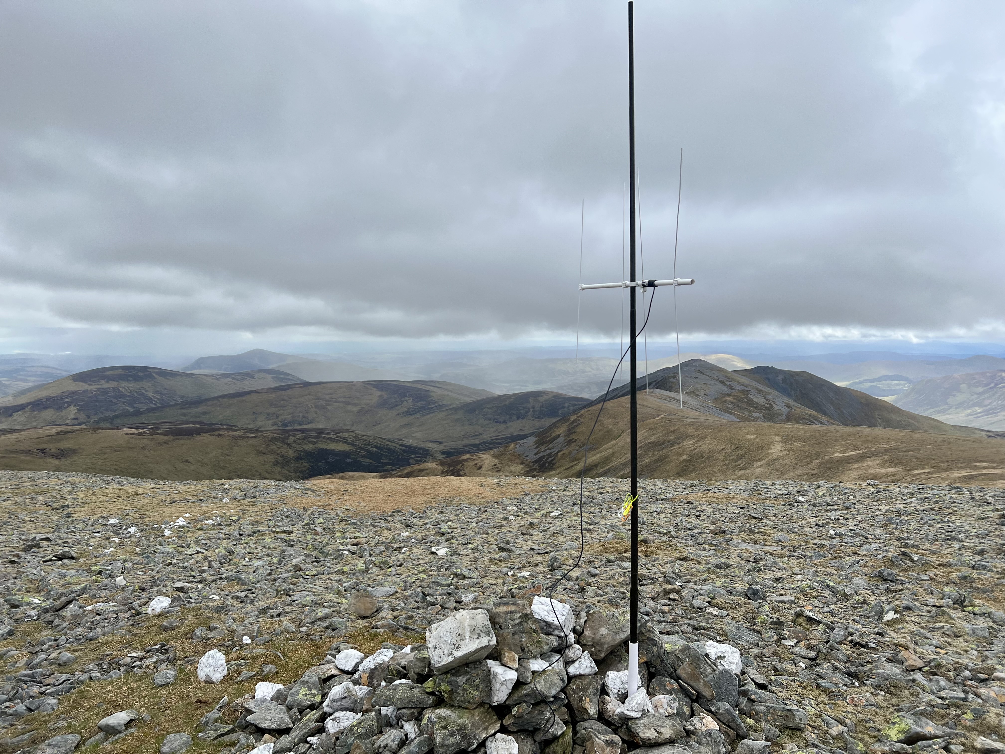
The summit Cairn quickly came into view – quite a large cairn, with an adjoining low shelter. I was glad of the protection from the wind as I stood and surveyed my surroundings.

Summit of Mickle Fell
The overcast sky had broken into sparse clouds and the radar station on Dun Fell was glinting in the morning sun. Cross fell stood behind, showing the opposite face to that which I viewed the previous morning. To the north, Cow Green Reservoir Cow Green Reservoir looked near at hand. All around stretched remote moorland, the view was solely of Pennine hills and heather moorland. This is a fine hill, now one of my favourites of G/NP. The walk to the summit required some effort of rough terrain, with barely a trail in places. The summit was broad and grassy, with a good shelter. But above all, the shear feeling of remoteness, with only views of other hills.
I setup for 2m FM first, speaking immediately with G6AEK and then M7OUD/P (on his way up High Raise) and G7SXR. The contacts then ran dry for a while so I setup for HF. Just as I was unwinding my antenna I heard 2E0NMK calling, and we had a quick QSO to qualify the hill.
I finished setting up my antenna and then called out on 40m CW follows by 20m CW. Conditions seemed good, and I made a nice number of contacts, including a summit to summit into Austria.
As I was dismantling my antenna another walker approached the summit, and we chatted for a while about the surroundings. At about 1000hrs I had a last look around the summit area, and then began to retrace my steps.

Retracing my route back, this bit is the steep drop off the summit
Navigation was easy, with a clear fence to follow for the whole route, several of the stream crossings had convenient wooden bridges across them. The terrain was never particularly severe, and I generally found it to be a really enjoyable walk back to my bicycle.
On return to my bike I called the Warcop guardroom a second time to notify I had completed the walk. I then changed back into cycle mode ready for the journey back home.
The procedure for getting a permit was really simple, I emailed warcopadmin@landmarc.mod.uk and provided a copy of the access agreement. Within 24 hours, I had received my permit. All that remains is to activate the permit by calling the Warcop guardroom on the day, and then to deactivate following the end of the walk. The access agreement provides details of the route you must follow; no deviations from the route are permitted, and its worth noting that the trig-point for Mickle Fell lies outside the designated route.