Felt tip?? We could only dream of a felt tip! ![]()
Adrian
G4AZS
Felt tip?? We could only dream of a felt tip! ![]()
Adrian
G4AZS
Off topic alert…
I had to get up in the morning at ten o’clock at night half an hour before I went to bed, drink a cup of sulphuric acid, work twenty-nine hours a day down t’ mill, and pay mill owner for permission to come t’ work, and when we got home, our Dad and our mother would kill us and dance about on our graves singing Hallelujah.
And you try and tell the young people of today that … they won’t believe you.
That looks very good. However, my start point was more to the east of the point shown, which I guess is the carpark at the church?
The end point, where I gave up, is probably about right.
I think someone has an incorrect diary at that company. They say that the offer ends at midnight on “Monday 31st” when the 31st is today, Tuesday. ![]()
(other similar post seem very outdated)
Any place / software / script I can use to get nice and free topo maps in the UK?
I found some places like opentopomaps.org and another primarily for cycling I think (all seem to use OSM and the NASA height maps etc). But I can’t extract data.
I was hoping for something I can extract parts and export to PDF etc.
Thanks
Tasos
In my experience anything free isn’t worth what you paid for it!
The “print screen” button can be useful…
Brian
Tasos,
I use a OSM topo maps almost exclusively on my Garmin devices and Desktop.
I have full (mainland) UK OS maps too, but the level of detail is normally much better on OSM.
Combine the two and and you get the best of both.
The footpaths and trails on OSM are actually what is found on the ground today, not what was surveyed sometime in a previous century ![]()
Here’s a well known South Wales summit on OSM.
Notice the trails shown to the summit.

Now the same on OS.
Zilch in the way of summit trails.

Add in Google satellite imagery and street view, and we’ve never had it so good!
You can download pre prepared images for smartphone and Garmin dvices here:
Pete
I find Streetmap to be useful http://www.streetmap.co.uk/
It has a good search system so you can put in postcodes, NGRs or even just a name of a place and it usually comes up with where you want to look at.
I’ve done screen prints and printed them off in the past. I’ve just done a quick PrtScn, posted into IrfanView (Paint would work if you don’t have a favourite picture editing program) then selected part of the map, to get rid of the bits round the edge that I didn’t want, and saved it to a folder. I could print it out if I wanted to.
This is my setup on an Android smartphone:
Everything is free and fully offline. The “Alps” map from France to Austria uses 2GB on SD card. Maps are based on OSM and updated monthly. Two sample screenshots below. Note the numerous forest trails around HB/SH-001.
73, Markus


I’m using Locus for Android and vectorial offline maps (OSM + topo) for hiking, geocaching and SOTA. It is nice to be able to switch between different maps (OSM, google, satelite). You can also scan and calibrate paper maps
73,
Petronel
Luxury !
Well, of course, we had it tough…
wow this look nice!!
I got a Note2 that still works ok! Ill test it
‘HUG’ works for me backing up changes that have occurred in my full UK vintage Memory Map 50K (and to a limited extent my full UK 25K and tks again Jim CQK on this one - hi!). Check it out http://maps.the-hug.net/
Cheers
Jack ![]()
Thanks, Jack, HUG looks really useful
Adrian
G4AZS
I use maps from Talkytoaster – Here to help with your Garmin OSM mapping needs… on my Garmin etrex.
Stewart G0LGS
I use a Garmin GPSMap 62S handheld GPS. I have full UK maps to 1:25000 on it, but you can get OS style quality maps for pretty much everywhere in the world here:
these are routeable too, and can be used in the free Garmin basecamp.
Whenever I go abroad I get the maps for the area onto a small 2gb microSD, swapping out the 16gB one that has the UK mapping on.
It’s a cracking GPS and battery life is good too, easily all day if not too cold.
Sadly Bing seems to have stopped serving tiles for OS maps (besides their Web interface). I don’t know if there will ever be a work-around for this, but at least for now it means no free off-line OS mapping for Locus on Android. So even I am feeling tempted to undo the padlock on my wallet on fork out for one of the excellent packages featured up-thread.
In the meantime I down-loaded GB maps from OSM in vector form. This was pretty big (about 0.5 GB), but covers the whole of GB (other countries are available too):
Because it’s vector-based and the rasterization is done on your device, you can choose different themes. Also the night mode is reasonably effective.
Of course OSM is not as consistent as, for example, OS mapping. It’s only as good as the contributions people make to it. But that means when you make a track of a useful path as well as contributing it to the SOTA mapping project you can put it on OSM.
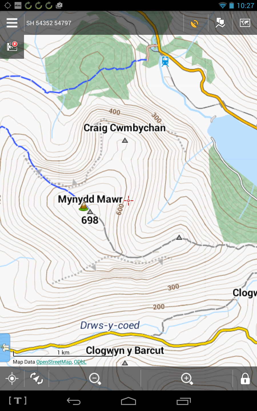
Here’s what it looks like in Locus Pro:
Simon
I have been playing with maps from OpenAndroMaps and Orux on Android. The contours are at 20m which is a bit course but the detail and size of files I think is very reasonable.
The Belgium_Hilke map I used when I was in Benelux recently. All of Belgium is included included significant spilage into France, Germany, Luxembourg& Holland. When I figured out how to cut screen a shot from my tablet and post it here I’ll show you.
Belgium_Hike is 290MB
Germany_South_hike is 729MB
Great_Britain is 808MB
These are small for the detail offered. Anquet’s 1:50000 OS HD, 1:25000 OS HD, OS Road Map and Name Gazetteer and heights database is 19.6GB in comparison. The full install is about 58GB!
For Android check out Here.
Free app and you can download the mapping for offline use. They are the same people who do the under the hood mapping engine for garmin car saynavs.