Visual and not radio but impressive nontheless.
10 Likes
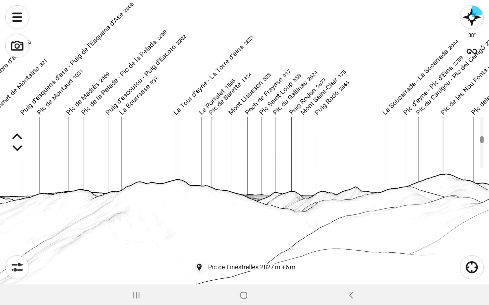
In this context I would like to introduce the Android App Peakfinder.
Here you can display the visible summits from each location. In addition to GPS and the summit name, the location can also be selected using a map.
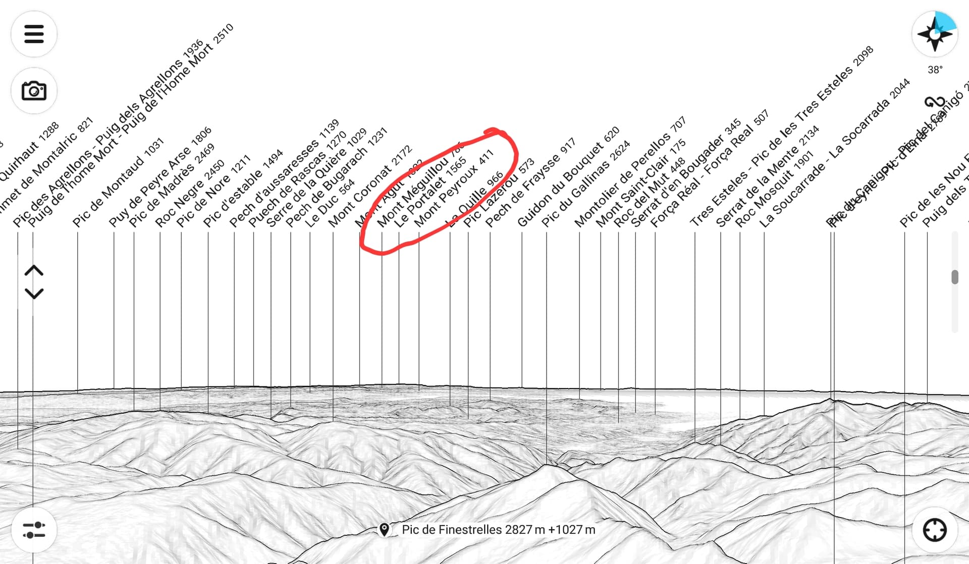
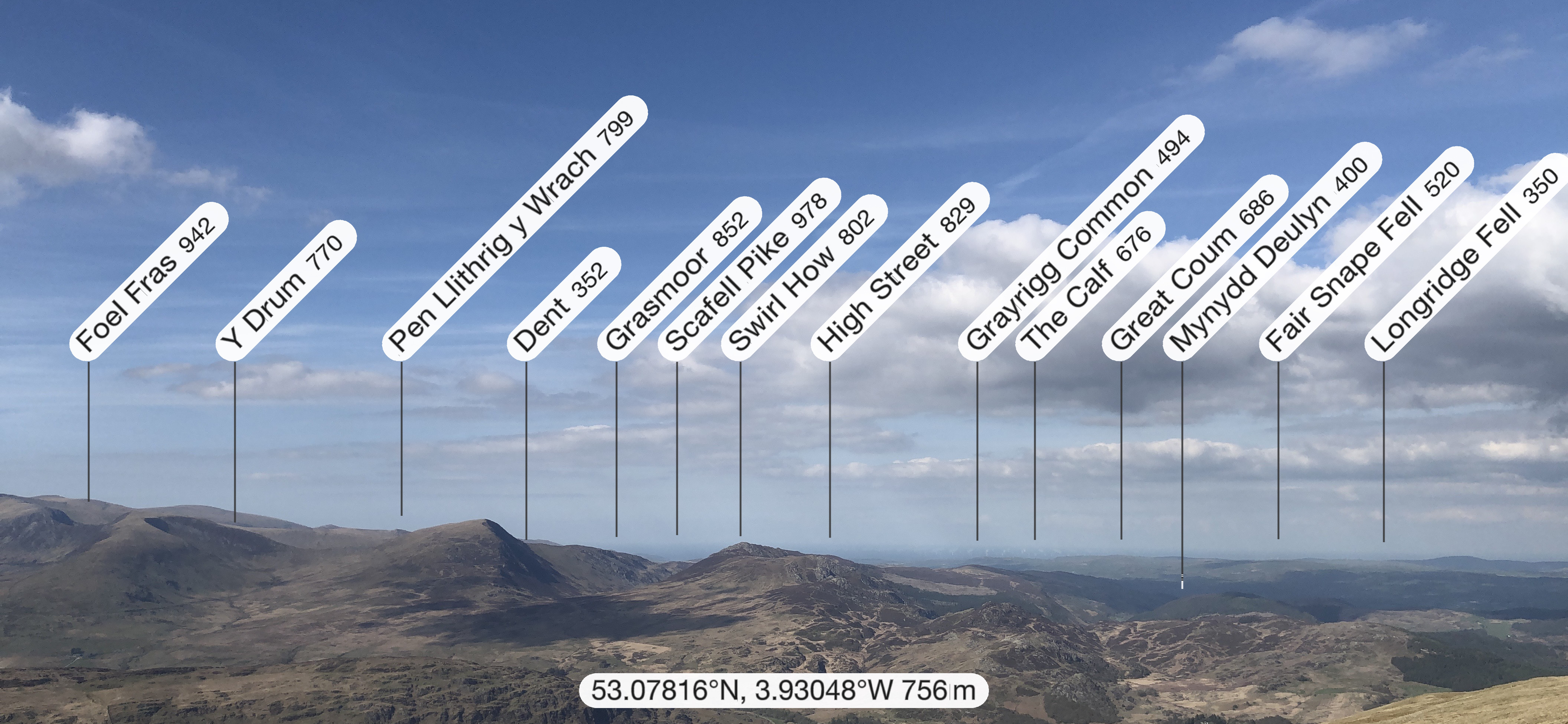
I found the location of the photographer and got the following image 1. The peaks of the Alps, 400 km away, are not all displayed, fortunately. But you can change the viewing height at the same location as with a drone flight and then an Alpine peak appeared on image 2.
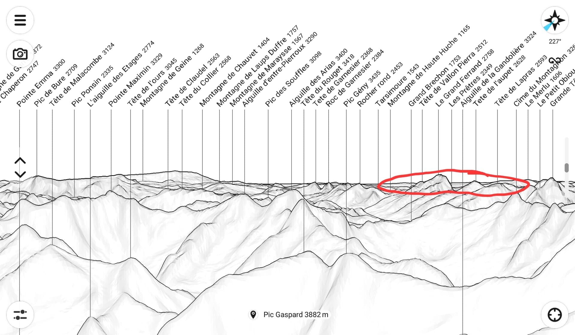
If you fly virtually to Pic Gaspard, you can see the Pyrenees on the horizon in picture 3.
Have fun trying out the Peakfinder.
73 Chris
5 Likes
So EA3/GI-006 to F/AB-012 might be possible with a 2m FM handheld? Maybe not quite what Jarek @SP9MA was hoping for - Ignacio why did not it work ? - but this would still be a cool experiment/sked!
4 Likes
A few distant galaxies can be seen quite easy with naked eye ![]()
OK - I’ll go now…
2 Likes
![]()
![]()
![]()
From a climbing/mountaineering forum:-
https://www.ukclimbing.com/forums/hill_talk/the_view_from_snowdon-571973
or this one
1 Like
The path is over water for some of the journey. So it should work as long as there are no strange ducts occurring lifting or lowering the radio signal. Again, ducting excepted, should be doable on many microwave bands.
This is the link system for UHF TV to Shetland. The mast is on Fair Isle, 66miles from the TV transmitter on Orkney. The two UHF (480MHz) receive antennas are highlighted. They have to use space-diversity to overcome the way the signal fluctuates over the mainly sea path. The link receivers will pick the best signal from either antenna and use that.
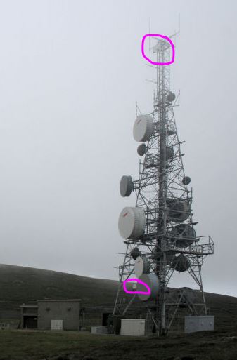
Here’s a zoom on the bottom UHF receive trough antenna.
Lots of fun sending VHF and up signals over water ![]()
7 Likes
It’s also available for iOS.
Great app and use it on most summits to see what else is around me and have an image superimposed in it.
4 Likes
That could work. For example at a distance of 400km, the theoretical free space attenuation is 136db on 2m. At 5W at the dipole, approx. 37dbm are radiated. So -99dbm arrive at the receiver. That’s about 2uV or S8 and that’s enough for noise-free reception. Assuming there is no additional absorption.
73 Chris
2 Likes
Interesting topic and comments
A long time ago I used to sit on a peak at 5,950 ft and work AE. I could on a clear day see the contrail start some 520 km away as the aircraft climbed through 20,000 ft on its way to 36,000 ft. Sometimes I caught a glint of sunlight off the aircraft. A short time later I could see the spot of light that was the aircraft leading the contrail.
A long way for terrestrial eyeball. Easier to see against the blue sky than mountains on the horizon. I think 160 km is about as far as I have seen distinct mountains I could Identify.
With my IC706 I could work 700 km on 2 m and 70 cm.
73
Ron
VK3AFW.
4 Likes
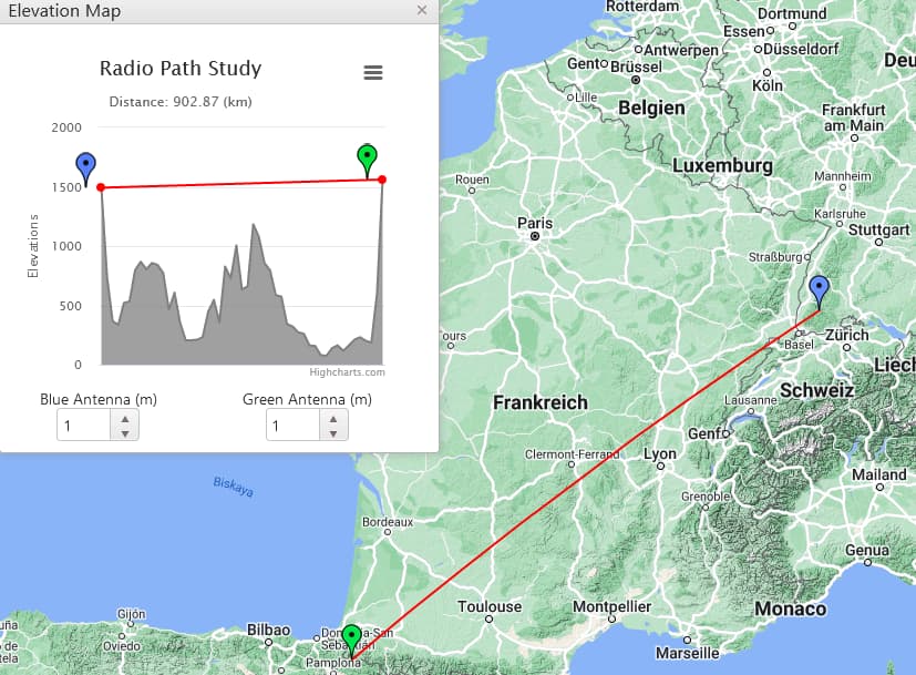
Taking into account the curvature of the Earth, is there not a 16km “mound” in the centre of this line that prevents it from being a straight-line path?
This result I am not convinced with BTW! It feels improbable. I was expecting something in the tens or hundreds of metres - not 16km. But I have repeated it three times using different approaches and keep producing this same answer. I cannot help but feel there’s a major flaw somewhere in what I’m doing!
1 Like
If they was a 900 km long line of sight path then I think the would be a queue of microwave have hams waiting to operate from it.
Yeah, my calculations were correct it seems.
I’ve now had a go at making a tool to check the path between two summits. This only checks if the straight path clears the curvature of the Earth in between and takes no account of (has no knowledge of) other mountains that may lie in-between. If you have knowledge of these, I guess you could subtract that from the “Clearance” output.
I’ve entered the ones mentioned above as examples, and there’s a few more lines in there for you to try out your own.
You’ll need to get the summit heights and distance between them yourself and enter manually. It’s probably possible to set something to look these up - but my brain is tired and clocking off for the day now!
3 Likes
Altitude is everything of course. A couple of balloons I’ve launched using 968MHz have reliably reached 300km using 25mW of power at about 9000m.
But the record is more than twice that.
2 Likes
Height is might as evidenced by F4WBY Height is Might For Radio Field Operations. - YouTube.
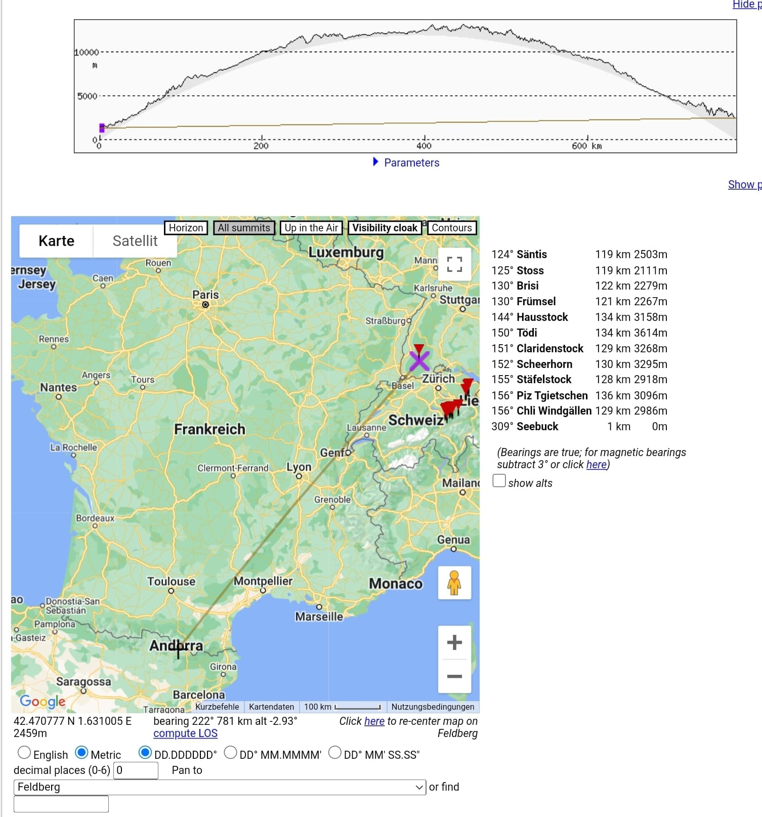
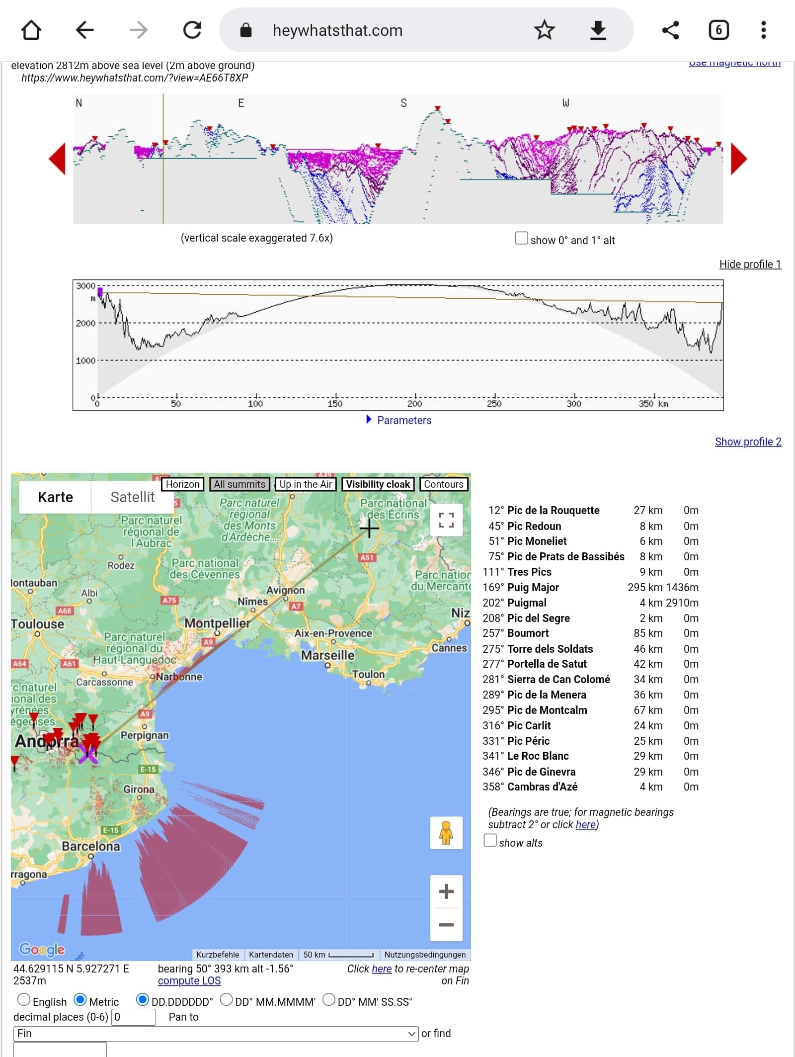
For bigger distances you’ll have to take into account the curvature of the earth. A tool to visualize is at HB9EYZ - QTH Locator Map OpenStreetMap - BETA.
Alternatively, you can use the ionosphere as a mirror ![]()
73 de Martin / HB9GVW
4 Likes
Some of us regularly used the troposphere.
1 Like
However, the curvature of the earth’s surface is not taken into account.
The website www.heywhatsthat.com does this and shows the visible area in red.
73 Chris
2 Likes
That’s a cool site. Thanks for the link.
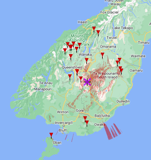
A personal challenge for the last 2 decades has been to find a spot where I can see Mt Cook (ZL3/CB-001), Stewart Island (ZL3/SL-182), Mt Earnslaw (ZL3/OT-001) and Dunedin’s Saddle Hill (ZL3/OT-492). There are spots on the Old Man Range where I can see any 3 of the 4, but I’ve yet to collect the full house. That would give me a field of view >320km SSW/NNE and about 300km ESE/WNW.
I’ve yet to find a terrestrial spot on that website that manages it, but your linked website suggests that the top of the Kopuwai transmission tower would fit the role!
Matt
2 Likes