I have just added a line of sight calculator to my website.
I wanted something that could accept a summit reference for either or both points.
You can also use an os grid reference, lat long or a uk postcode.
21 Likes
That’s brilliant. Thanks Paul.
1 Like
There are a number of on-line line-of-sight calculators. Many of them do not take account of the Earth’s curvature. They are accurate only for short distances between summits. Many will be surprised to discover, no matter how high your summits are, like an Everest to another ‘Everest’ how the Earth’s curvature makes LoS impossible beyond a certain distance. And that’s assuming the Earth is a perfect sphere (with no ‘bumps’) between summits.
Even fewer models take account of of the intervening terrain (like a higher mountain) that would obstruct a LoS path. Usually that needs a high-resolution Digital Elevation Model (DEM).
1 Like
I am only using a medium resolution EU DEM as that is available from open topo for free ![]()
2 Likes
…I found this only works in the uk. Not VK.
Geoff vk3sq
1 Like
Just tried it from VK3/VN-016 Mt. Alexander to VK3/VU-009 Mt. Ida. Known to be line of sight (have been up them both 100’s of times, sometimes even for SOTA). Shows as “not LOS”. Looks like the maths has problems with VK. Hope it gets fixed ‘cos it looks like it could be a good resource. Cheers, Phil
3 Likes
It appears to work fine in DL - perhaps this is a northern vs southern hemisphere issue?
73 Ed.
1 Like
It should be fixed now.
The problem was to be honest, that I hadn’t considered outside of Europe. I was only using an EU elevation model. The tool now selects the correct elevation model, depending on what part of the world the summit is in.
4 Likes
And it’s rather good Paul ![]()
I spent the last 20 years modelling. (pre-silicon semiconductor simulations as opposed to glamour or clothes ![]() ) and what you learn backs up the old joke “the difference between theory and practice in practice is greater than the difference between theory and practice in theory”. I have run your calculator on some known true LOS paths and some which were scratchy on 13cm and it’s giving results that are very close to what I observed for flat band conditions. I have only run it using the 23cm option and on 13cm the Fresnel zone is narrower, results maybe better. But as it stands, it is agreeing closely with observations. By the time you get to such scratchy/marginal contacts on 13cm, there is a good chance you and your QSO partner may well be able to use a common reflective area for a better signal.
) and what you learn backs up the old joke “the difference between theory and practice in practice is greater than the difference between theory and practice in theory”. I have run your calculator on some known true LOS paths and some which were scratchy on 13cm and it’s giving results that are very close to what I observed for flat band conditions. I have only run it using the 23cm option and on 13cm the Fresnel zone is narrower, results maybe better. But as it stands, it is agreeing closely with observations. By the time you get to such scratchy/marginal contacts on 13cm, there is a good chance you and your QSO partner may well be able to use a common reflective area for a better signal.
This is therefore a rather excellent tool for those of us who play on the higher bands never mind its usefulness for 2/70.
2 Likes
Thanks
![]() I have on many occasions throughout my career had to explain that to people.
I have on many occasions throughout my career had to explain that to people.
See my post below for another fringe example ![]()
1 Like
Everyday is a school day![]()
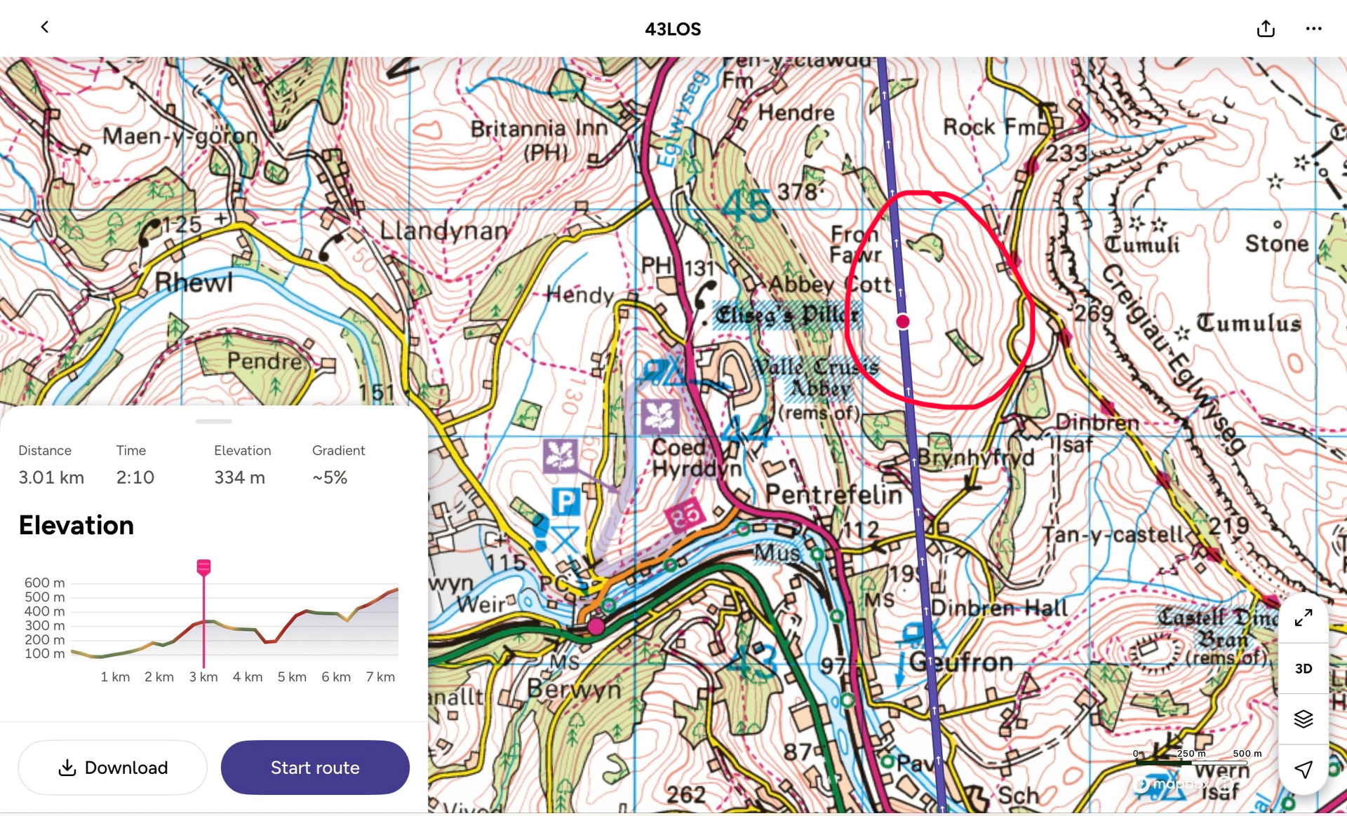
For some years, I thought could just squeeze my 2m wave along the side of a lump of rock that stands between my house and GW/NW-043. I have struggled with many a QSO on that summit, but always assumed it was all down to the transmitter station.
Well it turns out that I seem to bounce over the shoulder of that lump of rock. This probably accounts for some of the variability I get with QSO’s on Cairn y Brain. But this also shows that in marginal cases other factors come into play beyond the theory.
Contains OS data © Crown copyright and database right 2026
Contains OS data © Crown copyright and database right 2026
1 Like
You need to go and build a big reflector to bounce the signal around. Just like this…
2 Likes
Well it’s funny you say that ![]()
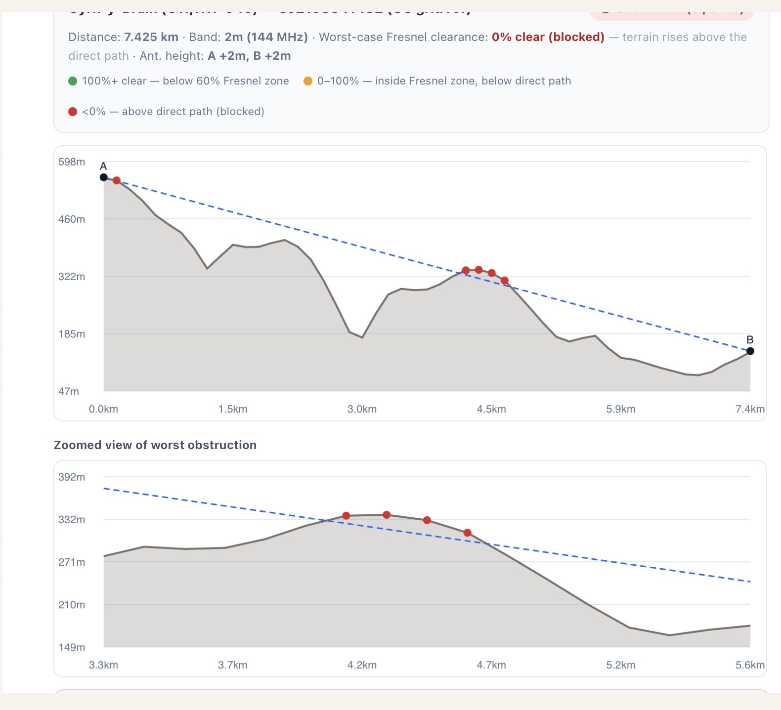
I live on the south side of the Dee Valley, across the other side of the valley is the large expanse of Trevor Rocks (behind Dinas Bran castle ruins) with almost vertical rocky sides. This rock mass acting as giant reflector is the only explanation, that I can think of, how my MW0PDV-14 igate, located at my friends, manages to ping my -12 igate at home. Especially when you look at the LOS plot below.

1 Like
Thanks Paul. Works a treat.
Cheers, Phil
3 Likes
Brilliant!
So there is line of sight from Oteake in Otago to the Banks Peninsula at Christchurch. I always wondered. Meaning 2m S2S from Central Otago into those popular Canterbury summits is possible after all! Not found anything further south or inland except the odd peek through the gaps to Mt Cargill in Dunedin. But a great tool to play and explore with.
Now, I just need my 2m SSB radio (FT818) back (and working), and I could play catch-up in the latest challenge.
Matt
5 Likes
Due to the tolerances of the elevation models, I have now added a check for marginal cases. So if a path only clears an obstruction by a distance less than the models tolerance, it warns you as in the screenshot below. For Europe the vertical tolerance is ± 7m, but the note wil tell you the tolerance for the dataset in use.
Also the documentation has been updated to reflect the added data sets and the tolerance check.

2 Likes
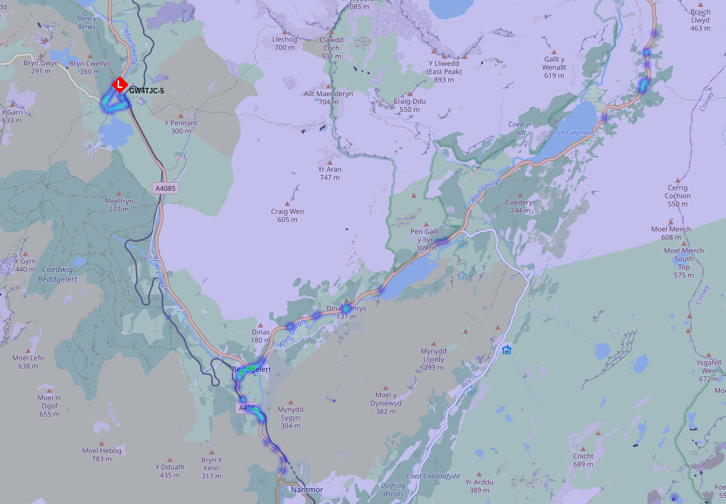
That’s pretty cool. Similarly there are some pretty wonderful packet paths being picked up by Simon @G4TJC ‘s Lora igate in Rhyd Ddu (GW4TJC-5) - look at the packets picked up due east especially:
Using your calculator:
2 Likes
That whole area has a limestone bedrock which is relatively transparent to radio waves and does not reflect well. Nor does it attenuate as much as others. It might be more like a building or a group of buildings doing the reflecting especially if they are those prefab metal light industrial units.
Getting some avid microwave users on the case could help pin point the path.
Another question, is “how many light aircraft do you get flying" around”. I say light aircraft, since at that horizontal distance, you wouild need the aircraft to be pretty low unless the transmitting antenna had quite a high level of vertical radiation. Its something I’ve been playing around with at home is AS on 23cm, but untill I get the rotatable antenna up I’m limited to just monitoring the Martlesham Beacon in Norfolk but only when an aircraft of size Boing 737 and above is >30,000 above Nottingham.
Shame really as Malham cove might have made a great EME reflector dish ![]()
Its certainly a useful tool as Ive been using other similar utilities to check out possible paths from G/SP-017 on 23cm but those don’t indicate the fresnel zone.
2 Likes
I do have to say it’s unreliable path, that seems to work in certain conditions. It will sometimes ping my home igate every hour, and then sometimes nothing for days. It’s not a problem as both have their own internet connection. But it is curious how it manages to ping at all.
1 Like
Any chance it could accept Maidenhead locators?