Not quite sure if this falls into the Summit info.
On Twitter I saw a post about activation zone mapping http://activation.zone/
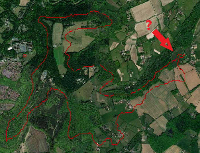
For example GW/NW-070 - Great Orme
It gives a “guide” but the data is simply not accurate or granular enough to know for sure… But I too will get some pop corn. I just plotted my local summit and this plots the AZ with a main area and a small separated outlying area which is impossible in real life (per the rules). Once you leave the AZ (drop by 25m), you cannot re-enter it elsewhere!
As many have said, Google’s data is lacking the required accuracy. But it’s indicative of what the AZ may be like and as long as you treat the data with care and caution then it has some use.
someone should probably contact N6ARA the author about the separate isolated areas mentioned above. I just tried it on G/SE-005 which has a very convoluted AZ and it looks mostly correct, certainly good enough to be used for rough planning.
It all depends on the quality of the available data, and certainly an individual assessment of a summit.
I had my experience with this already, see the thread below.
73 Jens HB9EKO
AAAghhh!! That brought back some memories. My wife went off for a stroll whilst I was activating it, and got lost. An hour or 2 later (having driven round the one way system a couple of times), I finally managed to track her down. It’s SOO much safer on the big wild hills in’t north (she doesn’t wander as far)
Thanks - a really useful tool - and helpful along with images etc to work out what space there is at the summit so there is a better chance of arriving with a suitable plan and antenna! Q) Am I unusual in spending quite a lot of time with Maps (In the UK I use OS Maps) , Google Earth and Streetview before an activation?
Consider also that typically when anybody asks what is the AZ limit for a summit it’s because they want/need to use a “dodgy” location right on the edge - maybe inside, maybe not. So they’ll need the most accurate data to be had.
We don’t even know the provenance of GE data and can’t say much about its accuracy. Often also it can come down to horizontal resolution and whether or not those little “islands” join to the real AZ or are separated by a narrow channel that takes the dip too low.
…no just want to keep any antenna well away from members of the public and want to know how much room I have to play with! (Thinking about radiation and distance from the antenna)… for me a “dodgy” loaction is one where my 80m linked dipole ends up too close to the path!
Good, but from the AZ rule “The Operating Position is taken to be the position of the operator” so you don’t have to worry about the ends of your antenna going beyond the AZ boundary. Indeed, one setup I mean to try sometime is a λ/4 vertical for Top Band hanging down a cliff from the summit, so obviously the end is bound to hang below the AZ but the operator and the rest will be in the AZ.
… agreed but I dont want to have to abseil to recover the end of the antenna! ( PS I was thinking about a kite quaterwave for 160m, but to get half decent propogation it would involve flying it in the dusk…)
My mate’s mate Malcolm used to fly Cody Man Lifter kites. Five big versions of them in a train to support the line and another Cody Man Lifter to pull the basket up the line that the man stood in. As he would say “you need an adequate support to attach the line so it doesn’t move.” A LWB Land Rover was not adequate, a single Man Lifter could slowly drag an LWB across runway grade tarmac in a good wind!
Talking of inaccuracies, there was a well-intentioned but incorrect activation of Snowdon/Yr Wyddfa yesterday because the activator relied on on the Summit Tracker function of the SOTA Goat app. Basically the app said that the lesser peak of Crib y Ddysgl was within the AZ, being only 20m lower than the main summit, but it didn’t take into account a drop to the intervening bwlch of 86m.
The details are on the GW SOTA page of Facebook if anyone is interested in the fine details of the case. It just shows that technology isn’t always to be trusted! Ps- talking of the Activation.Zone app that John MOVAZ refers to, I see coincidently that it doesn’t seem to work for Snowdon…

 for the show…