Yuck! Non SI prefix.
Yes, hence relative measurement on a short time scale. But temperature will doubtless vary on a shorter time scale than P, especially if e.g. the device goes in/out of your pocket.
Yuck! Non SI prefix.
Yes, hence relative measurement on a short time scale. But temperature will doubtless vary on a shorter time scale than P, especially if e.g. the device goes in/out of your pocket.
I am proposing a small engineering project.
Get such a barometric sensor. Put it in a ‘oven’ like we know from oscillators or quarzes.
Add an arduino or other development board with a display as user interface
Up/down buttons to set actual height at summit after equlibration time.
See how good it works 
I knew there were 2 and I’m sure QNH is the one in VolMet reports. Gosh it must be last October when I checked VolMet on 60m on a summit to get a quick view to band conditions. ![]()
Even better, do-it-yourself DGPS. There are some projects for this.
Of course that would mean leaving a station at the actual summit.
Quite Phil. It’s all part of what I really enjoy about the SOTA activator programme. Why would I want to surrender some of that enjoyment to an algorithm?
Maybe I’m being too cynical, but I ask myself if that kind of accuracy from a smartphone is possible; even with AGPS. Like any computer, it must be quite noisy inside a modern smartphone. My smartphone often suggests it has a much better signal than it really does, so I’m not entirely trusting of these things.
Whilst we’re on an aeronautical theme: sports like gliding allow some latitude when reading heights from a GPS, precisely because of this inherent inaccuracy. I can’t remember how much, but is this something we should consider? For example:
An activator’s GPS says that they are 27m below the summit.
After taking into account the inherent inaccuracy of a GPS, we decide that they may still regard themselves as being in the activation zone.
Beyond a set limit, say 4m outside of the activation zone, it is deemed, by the powers that be, that on balance, even with the inaccuracies, they cannot still be in the activation zone.
It’s just a thought.
73 de OE6FEG
Matt
Hi Ed,
I sometimes use Google Earth as well for a quick overview, but a couple of days ago, I found out that it has to be handled with care.
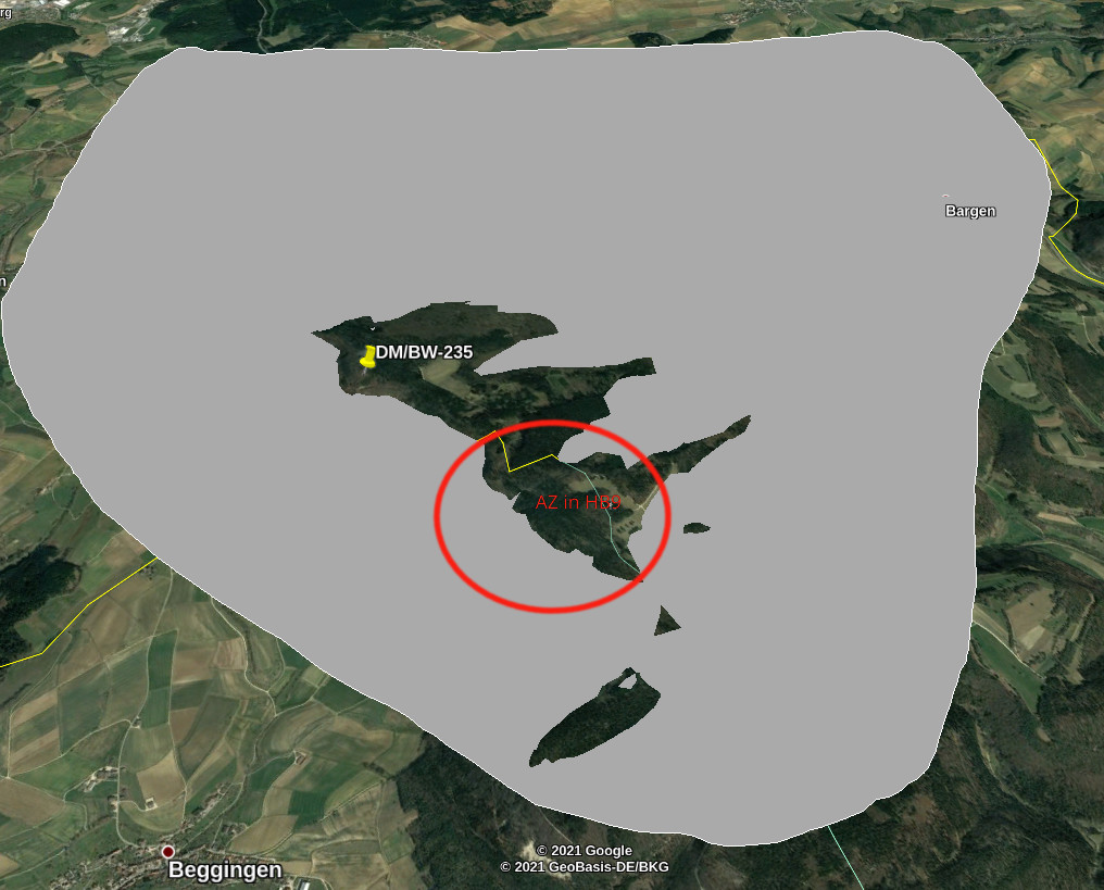
One example: On my search for easy winter bonus points, DM/BW-235 is a quick catch since I don’t live too far away. Due to Covid, and since I didn’t have a valid reason for crossing the border without prior testing, I wanted to check if the AZ extends into HB9 and approach the summit from that side of the border.
According to the summit database, the summit’s altitude is 924m, so I set the flood level to 900 m (1m safety margin). Google Earth says YES. (according to this info, the AZ even extends to the inactive summit HB/SH-001)
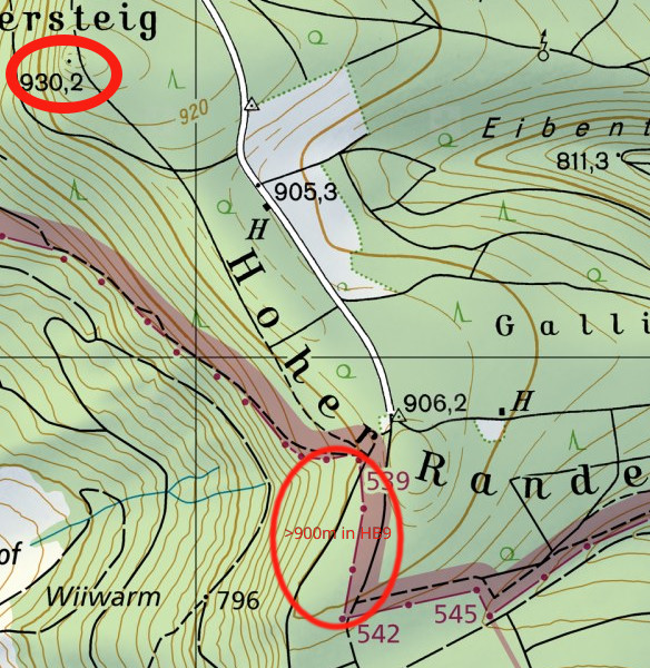
Since I am aware that the altitude lines in Google Earth are not always reliable, I doublechecked with the official Swisstopo maps. Here, the picture is different: Looking for the 900m altitude line, I found that there is only a small area higher than 900m on the HB9 side of the border. Which would be fine if the summit altitude actually was 924m. However, the Swisstopo map shows a point with 930m altitude.
(Yes, I should actually take the time to ask the association manager if he’s aware of that). Funny enough: I have the official maps of the area in DL installed as an app on my smartphone. In higher zoom levels, the map indicates the summit with 924m. If I zoom in closer, the map changes and shows me the 930m point ![]()
So in order to stick to the SOTA rules, the options I have is activating in DL when I have a PCR test done for something else, or when I have a reason to cross the border that qualifies for an exemption, or I’ll just wait until I don’t have to bother any more why and how I can cross the border.
Summarizing it, the flooding tool is a good entry point when preparing a trip and looking for convenient places to set up the gear within the AZ. However, I wouldn’t use it as a bulletproof evidence that I was in the activation zone. At least not without further verification on an official map.
73 Jens HB9EKO
I’m shocked - shocked I tell 'ya - that no one mentioned the SotaGoat app for iOS devices. Click “tracker”, which shows the distance and bearing to the five closest summits. Click the desired summit, and a full width strip-banner in the upper half of the page says “outside AZ”. Keep climbing, and the banner eventually turns green and says “inside AZ”. A compass and altimeter occupies the lower half of the page, whilst pop-up spots appear from time to time. Does everything but brew your tea.
Elliott, K6EL
Great minds think alike. I’ve used inverted V linked dipoles or EFHWs for all my SOTA HF activations until now. But my Chameleon MPAS Lite HF vertical arrived yesterday afternoon which I bought for rapid deployment and small footprint away from the tourists somewhere in the AZ on G/LD summits. Just awaiting the gale force winds and heavy rain to abate to try out my new toy.
BTW: The reference level in DL for 0 m asl is the North Sea and for HB9 we use the Medeterrianean Sea. The difference is 27 cm at the DL/HB9-border. In 2003 they built a bridge over the river Rhine at Laufenburg and they were 54 cm off. Guess what …
73 de Dominik, HB9CZF
Ah, well, that’s why we Brits don’t think of it ![]()
That explains why one map indicates 930,2m and the other shows 930m at the same location ![]()
How does it verify the correct altitude of th summit with an official map? And how is the altimeter calibrated?
I think all kinds of tools are quite helpful, but can’t take all kinds of uncertainties into consideration, as in the mentioned example.
73 Jens HB9EKO
Yes, provided that the pilot adds the 1000 feet of safety altitude from any obstacle shown on the chart that he is going to overfly, and doesn’t fly towards low pressure - from high to low, beware below !
If flying in cloud, avoid cumulus granitus ![]()
Note the distinction between AGPS (assisted / augmented GPS) which speeds up acquisition by using a network connexion to receive the satellite ephemeris more quickly and DGPS (differential GPS) which uses extra, fixed receivers to allow for the ionospheric phase variation, giving you a more accurate result. The latter is what allows surveyors (and indeed the Relative Hills of Britain guys) to achieve tenths-of-a-metre elevation accuracy and centimetric horizontal accuracy (or even better).
This is why we really like more than just Google Earth or public DEM sources for building summits lists. Especially for spikey summits, where the typically course (relatively) elevation sampling grid can smooth out the maxima, never mind any other error sources (all unknown for the proprietary data).
Just downloaded SOTAgoat to my iPhone. Looks good. Only £2.99. It confirms my sitting room is outside the AZ of my local summit, Arnside Knott AZ. Gonna walk my dog there now and will use this app to see how easy it is to identify the boundary of the AZ.
I always think it sounds ugly in plain language - hectopascal.
Yes, of course, I should have remembered that. The question still remains, as to why a smartphone can never be as accurate as a Leica surveyor’s GPS. And what kind of accuracy the increased system noise in a smartphone limits it to.
73 Matt
I am absolutely not an expert in this, but I think:
GNSS accuracy is itself improving (better clocks so the satellite TX is more accurate) which will surely improve even consumer device accuracy. But ultimately you’ve got to do something to cancel out the effect of the ionosphere. I doubt RX noise is that much of an issue as these things are pretty bright (too bright, speaking as an astronomer!!) when they are line-of-sight.
Internal clock accuracy, repeatability, stability etc.