I found the following site, which as it displays weather forecasts for summits, rather than a nearby (lower) town or city, I thought might be of interest to other activators.
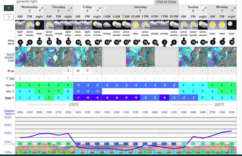
Unfortunately - this is what it is telling me about my summit on Saturday!
I gave up using that site as I wasn’t very convinced by the accuracy of the forecasts. Also, it thinks it will be sunny at 7pm despite the sun setting two hours earlier.
there are as many different opinions on this subject matter as there are forecasts! The only really accurate forecast is experiencing the here and now (not much “fore” really).
To me this looks similar to Windy, but I didn’t compare them in detail.
When I’m abroad, I usually use meteoblue. You can even compare the different models and they deliver the real-time weather for the Microsoft Flight Simulator.
For Switzerland, I think nothing beats the free and official meteoswiss app, that is very reliable and is packed with cool features.
Interesting view. MWIS has been my “go to” for the UK hills for many many years. I go back to when it was Geoff Monk on his own providing a fax service only that got out up in outdoor shops in the early 1990’s
I’ve been using this website for a good year now and to be fair, it isn’t far off! I don’t think anyone will ever find a wx forecast that predicts the correct wx everyday. Don’t get me wrong, it has made a mistake on quite a few occasions but I still find it to be 75% correct most of the time! I’ve compared it to ‘Met Office’ on times, and Mountain Weather is normally more accurate!
I think they’d be to scared to predict the percentage of confidence because they wouldn’t be confident enough to do so in other words it’s a 50/50% chance that they’ll be right!
How many times have you summated this year when the forecast says sun all day and you end up with pouring rain or snow on the top.
do you know which forecast model they use? I can’t find a hint on that on the site. Free models usually lack resolution, e.g. GFS 28 x 28 km or ECMWF 9 x 9 km. I wouldn’t rely on such models in the mountains.
Having a quick look at the site, it shows that there is no wx station on any summit of the northern mountain ranges (except Brocken, Harz). Even worse, the only mountain in the Weserbergland they know is Große Blöße. No Köterberg, Hills, Vogler, Ith… They even think that Wilseder Berg and Falkenberg (both close to Hamburg) are located in the Wesergebirge.
I don’t get why they seperate Achtermann from Bruchberg and Bocksberg (Harz). All three are only a few kilometers away from each other and peak at similar heights. Again, the only wx station is on Brocken and they probably use a low-resolution model.
IMHO, a high-resolution model with a dense net of wx stations on the main summits is needed that takes the local peaks into account. Not a life-threatening issue in the DM northern mountain ranges, but in the ‘real’ mountains you might be lost otherwise.
Having said this, for the DM low mountain ranges I still would prefer Kachelmannwetter.de which offers a variety of different high-res models down to 1 x 1 km and a decent net of of wx stations of which several are located on summits.
So far the predictions for the Wank summit seem in line (and a few degrees cooler) with that Accuweather, BBC and others give for Garmisch-Partenkirchen in the valley below this summit.
Of course, if there aren’t any weather stations on the summit you are interested in - results will be questionable.
Do you know of any other websites that give accurate weather forecasts specifically for mountains?
73 Ed.
Hi Stephan,
What I particularly like about Meteoblue is the where to go “(example for Freiburg)” feature. It shows the area within a defined range that has the least probability of rain. You can set the range yourself depending on the distance you are prepared to drve. The forecast for the where-to-go region also shows the level of confidence for this prediction. If you are in doubt wether you should select the summit north to you or better the one in the south for the weekend, this could be of great value.
OK, seriously. As said, for the low mountain ranges Kachelmann is my personal choice. It’s not easy to handle due to the high number of choices, but if you fiddle around a bit with it and learn how to use it, it gives quite good results. Here’s some guidance.
The compact forecast and forecast XL automatically choose the model of highest accuracy for the chosen place and period of time. Circumstances on summits are taken into account, i.e. wind, windchill, temperature and rain probability.
There are wx charts based on different models. I find ‘Signifikantes Wetter und Bewölkung’ very useful to see where the weather comes from and to compare different models against another. ICON-D2 and other HD models seem quite good in this case.
The ‘rapid update’ charts are useful when it comes to unstable wx and you want to know if you can get back safely to the valley in the next hour before the storm or heavy rain hits you. Do not use for a period of time more than some hours ahead.
I use different weather services, but mostly I rely on meteoblue.com as their forecasts seems to be the most accurate … meteoblue is a meteorological service created at the University of Basel in Switzerland.
Apart from the nomal forecasts (you can search for mountaintops also … at least for Austrian mountains) I like to use their weather maps with satellite pictures and rain radar:
And recently I discovered the “where2go” feature, you can find the best weather around a selected place (e.g. for Salzburg):
There are also apps available for android and iPhone:
I activated Cracoe Fell G/NP-032 today. I checked 3 sites for the weather.
MWIS for the Yorkshire Dales was very pessimistic suggesting low cloud with rain or drizzle all day. This covers a large area including some much higher hills so this isn’t too surprising.
Mountain Forecast thought Thorpe Fell Top (the nearest mountain [just along the ridge] and actually the previous SOTA summit G/NP-025) would be sunny intervals all day with no rain.
The Met Office doesn’t list that summit so I looked at the forecast for Rylstone, the village where I park. It said there was 50% chance of rain until 3pm when it was likely to be dry.
The Met Office were spot on. There was a steady succession of rain followed by short dry periods. Then almost at exactly 3pm the rain stopped and it was dry for my descent and walk back to the car.
So this confirms to me that Mountain Forecast is not worth bothering with and the Met Office is usually pretty accurate.
 in other words it’s a 50/50% chance that they’ll be right!