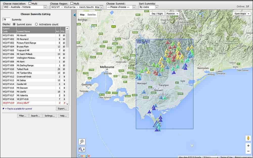
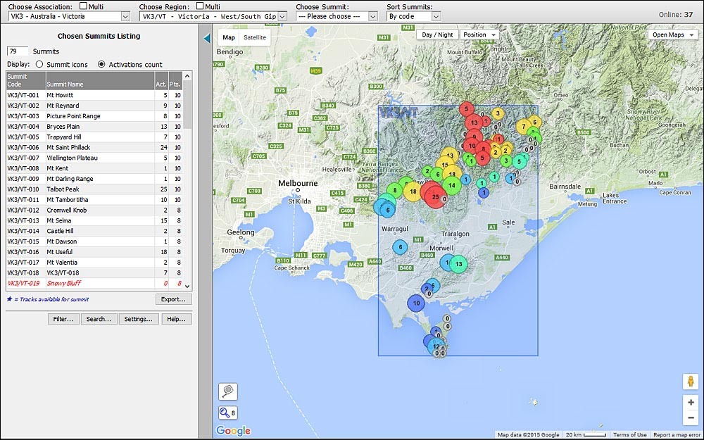
Had the bright idea yesterday of showing symbols on the map in the main page, displaying activations counts for individual summits, instead of the usual little triangles. It’s worked out not badly at all - here are the “normal” summit icons:
and here are the new activation count circle-symbols, where the size of the circles relates to how many activations each summit has had, and the colour indicates how many points:
I’ll have to add a small key on the right-hand side of the map to indicate which colour represents how many points, but that can keep for a day or two.
EDIT: in addition, one can of course always use the Filter button to choose to display:
I state that I’m a software developer and that I’ve worked in web mapping and realtime aviation tracking projects. So this is a proposal, Developer → Developer
In the page http://www.sotamaps.org/ a new function should be added called “Summit proposal” steps:
Activators or chasers insert during the year the new summits.
Summits enters directly on the Sota database “summit_proposal”
marked as “validated = false” they are proposed but not valid NOT USABLE : .
The nation AM receives periodically the list of proposed summits, or
better has a Backoffice access to directly validate them.
The MT, one per year move the validated summits from the
“summit_proposal” database to the “summit” database and they became
valid.
Summit coordinates revalidation steps function called “Summit adjusts”:
Activators or chasers enter in “Summit adjusts” and change the
position
Summits are copied from the summit database to the “summit_proposal”
marked as “adjusted = true” “validated= false”, the summit is still
valid.
The AM receives an email notification
The nation AM receives periodically the list of adjusted summits,
or better has a Backoffice access to directly validate them.
The MT, one per year move the re-validated summits from the
“summit_proposal” database to the “summit” database overwriting the
wrong ones.
I know that this lead to some programming work for volunteers, they have already done a big and fantastic work, but this could solve a lot of headache.
Paolo, if summits need to be approved or validated in or for SOTA, the process has to go through the normal channels. That means contacting the SOTA MT with any proposals for additions or alterations.
Excuse Rob, I’ll modify my proposal highlighting in bold the words “validate”.
Maximum respect to your work, it’s awesome and I appreciate It a lot because I know the hours of work that are behind it.
There is an issue at the moment with the the individual summit information boxes not closing properly once they are opened. Sometimes they will close on the first attempt, otherwise a complete region refresh is needed. I have experienced this on a few different machines.
I’ve made a number of alterations to the code in an attempt to prevent this from happening. There was also an issue where clicking on the infobox close button would, after closing the infobox, then open another infobox for a different summit whose symbol happened to lay directly beneath the position where the infobox close button had been - this has also been fixed.
Also added a key to the points colour scheme. I now have to try to optimize loading of the points circle markers which at the moment requires too many calls to the server…
[quote=“G2HFR, post:15, topic:12176”]
I have experienced this on a few different machines
[/quote]…a few machines scattered about the lounge there at G2HFR Towers, eh?
Hi Rob,
Two things -
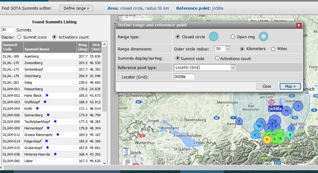
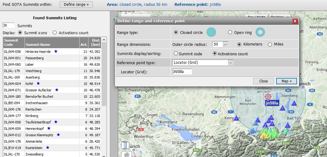
When doing a range request and setting Summits display/sorting to “activations count”, the map does not change from triangles to rings and doing a screen refresh effectively cancels the range selection, taking you back to where you need to define the range again, on the second attempt, the rings are shown.
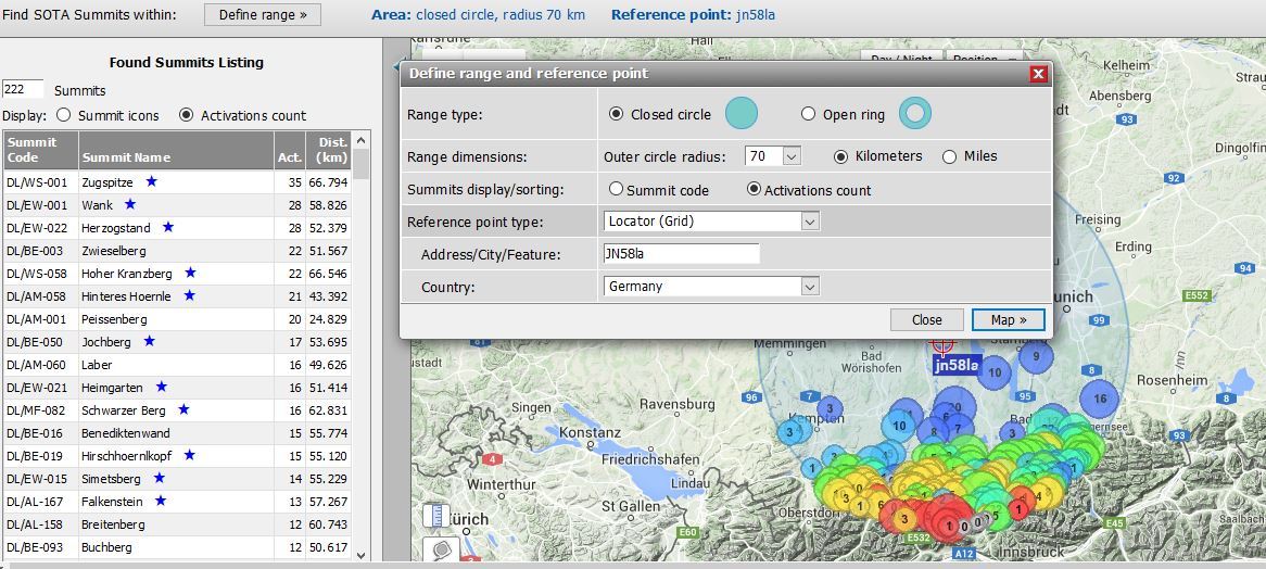
And (after the action above) - the Maidenhead locator option now asks for a country as well, as my range often covers parts of Germany and Austria, this is not practical - or if I leave the country blank, will it show all countries in the range (i.e. was this an intended enhancement?).
Hi Ed, I can’t reproduce those errors - maybe you could try a <Ctrl>+F5 in each of the range and main pages and see what effect that has. If you only do a F5, then several of the controls can/will keep their “state” between normal F5 refreshes - that’s especially true of the Define Range… window
One should always keep this in mind when major changes are announced in website code: <Ctrl>+F5 is the name of the game…
+F5 has the same effect for me as the refresh arrow - I go back to a world map and have to start the define range again.
I am using the latest Firefox version, not sure if that is relevant or not.
Also without doing a second complete range entry, just changing the Summits display/sorting option to activations count and hitting Map again doesn’t change the display with me from triangles to rings.
AHHH - just a minute - which Summits display/activations count should I be changing??
If I change the one at the top of the textual list on the left - the icons on the map change - it’s only if I change the setting in the define range box that it has no effect.
The reverse action proves this - Text List set to Summit icons and range box set to activations count - and we get Summit icons. Perhaps the option needs to be removed from the range box ?
I’m not sure how I got the country selection box to appear in the Range panel but it hasn’t done that since.
Ed.
P.S. take a look at the sequence of the summits in the text list though - with Summit icons selected, it displays in decending activations count and with activations count selected it displays in distance from home sequence. Shouldn’t this logically be the other way around?