Advice requested on how to use my Android telephone to show my location in Lat/Long while on summits or hills?
Tom/EI5CA
Hi Tom,
There’s a free app called GPS Status which shows Lat and long. I’m not sure what coordinate system is used in the south, but if you were to go to Northern Ireland or the rest of the U.K. then another free app called Grid Reference gives a six figure Ordnance Survey reference.
John
G4YTJ
Which Android phone? Which version of Android?
Open settings, turn on location (GPS).
Use Google Maps (installed by default) click the “my location” icon and wait. Your position will be shown on the map after the data downloads. You’ll need an internet connection for it to work.
Or download a fully featured map app like Orux maps and the maps for your country, enable “Settings/User interface/Dashboard/User interface: Coordinates” and enable “gps tracking” and the data will be shown.
Orux and the maps are free to download and use and you don’t need a live connection to use the phone as a mapping GPS.
John, many thanks for info on the apps. I will try and download them and see if they will help me.
Hope your weather in Birmingham is good. I worked in Romsley(Halesowen) many years ago!!
73’s Tom
Hi Tom,
Not far away from my home QTH at all, or G/CE-002 Walton Hill for that matter. Wx is good at the moment, thanks.
Let me know if you have any isses with the apps, though they just worked for me “straight out of the box”.
73
John
HI,
I use https://play.google.com/store/apps/details?id=com.chartcross.gpstest&hl=en
and share my location send on gmail account. Than you click a link an you get your location on googlemaps. Like this:
Google Maps
73 de s52ft BostJan
I use these:
gives a lot of info on your GPS, a bit like the GPS Status app
then this one :
https://play.google.com/store/apps/details?id=me.guillaumin.android.osmtracker&hl=nl
lets you record your track while you walk, add pictures, voice comments …
shows your track later on a map when you have WiFi , or export it to GPX format, which you can view and edit on your PC with a program like GPS Track Editor, which I found here
http://www.gpstrackeditor.com/ (Windows only)
On a summit, and if you have no data connection, there are several apps that can download offline maps and show your coordinates
I use the free MapsWithMe (click on your position, then “Mark your spot” will show the coordinates)
I’m sure there many other good solutions (OSMAND, OfflineMaps, etc)
73 Luc ON7DQ
Hi Andy,
Orux looked a good alternative to my present phone MAPS app but when I went to down load they wanted access to:
My ID, Hmmm OK
My Location: Hmm OK
My Contacts - No Way
My Photo and Media Files - No Way
My Bluetooth connection info. Absolutely No.
So I’ll stick to the stuff I’ve got with it’s peculiarities and shortcomings.
73
Ron
Ron, with a reasonably modern Android (5+?), you can be selective on what permissions you grant
If it’s just GPS position you are after https://play.google.com/store/apps/details?id=com.chartcross.gpstest&hl=nl
I also log GPS coordinates in my logging app VK port-a-log | VK3ZPF Ham Radio Blog which also displays Maidenhead reference of my location. Both values are then transferred into the ADIF file for upload to me Log4OM when I get home.
If I want to see where I was operating from I just paste the GPS coordinates from the comments section of my log into the search box of Google Maps and there it is.
Good for checking. Not sure why it needs your contacts, Photo and Media Files sounds odd, mine says storage so it can access offline maps you downloaded and write out tracklogs, Bluetooth is for Bluetooth GPS etc. However, questioning why a MAPPING program would want to access your LOCATION well yes that is a bit OTT.
I have a Cyanogen based phone, so privacy is options can be enabled after the app. i,e, you install the app and it says needs phone call access and you accept that. Then you go to privacy settings and disable it for the app. The app is happy as it had access on installation and I’m happy as the app can’t access what I disallow. That and regular updates makes Cyanogen worth its weight in gold.
Hi Ron,
I’m a happy OruxMaps user since several years. Here are the reasons why the app wants to access your…
-
Contacts: SOS function. Phone sends email or SMS after the device did not move during a specified amount of time.
-
Photos: You can attach photos to waypoints.
-
Bluetooth: Bikers use bluetooth devices which monitor heart rate and other parameters. Orux can integrate such devices and show/record their values.
Myself I am not using any of these functions. Much more important for SOTA are map overlays. Download summit lists from the sotamaps website and see all summits right on your map.
73, Markus HB9BRJ
2 Likes
What Markus says!
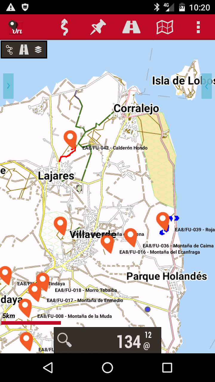
Here is my Oruxmaps view of Fuerteventura using a downloaded map with SOTA summits overlayed.
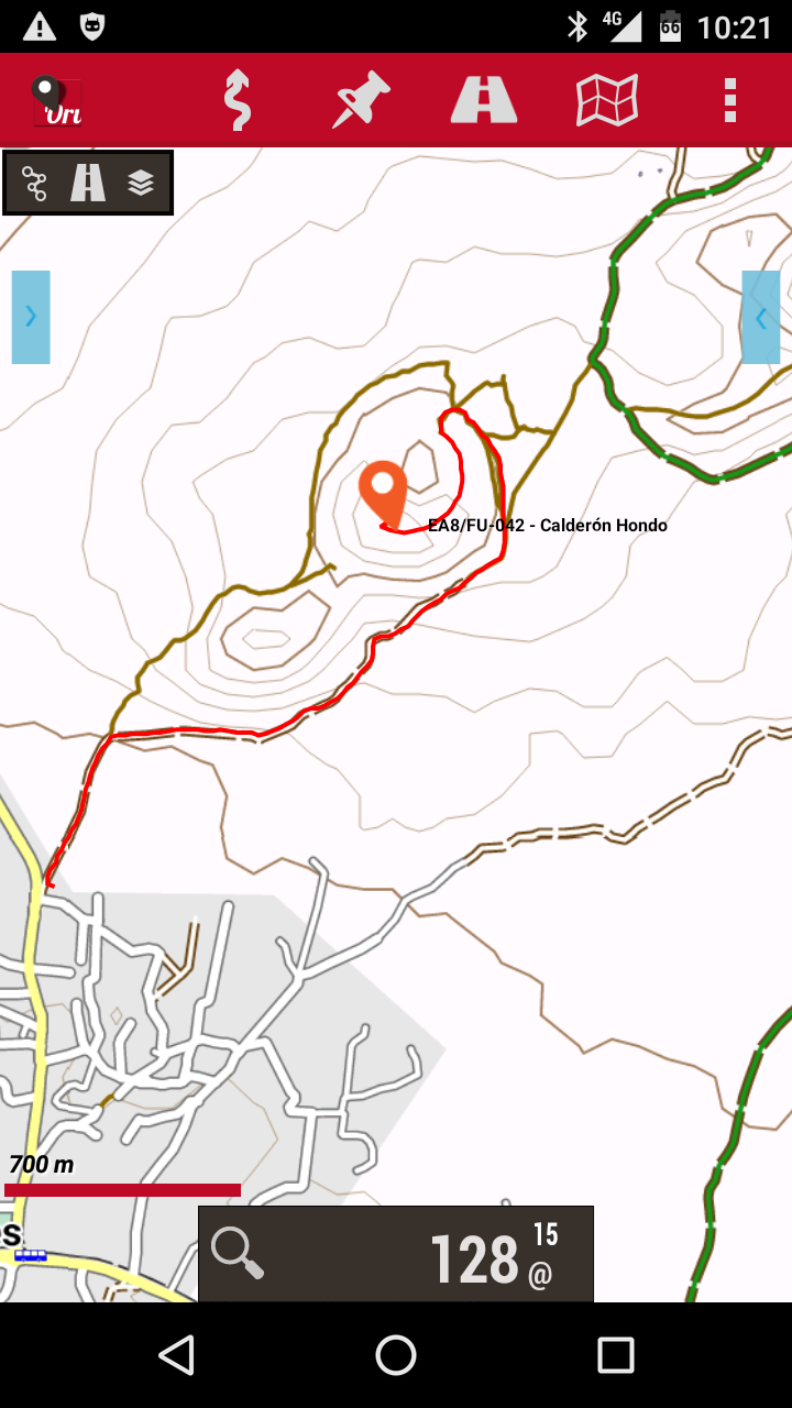
Here’s the view for a summit I activated for the NA<>EU event along with the tracklog.
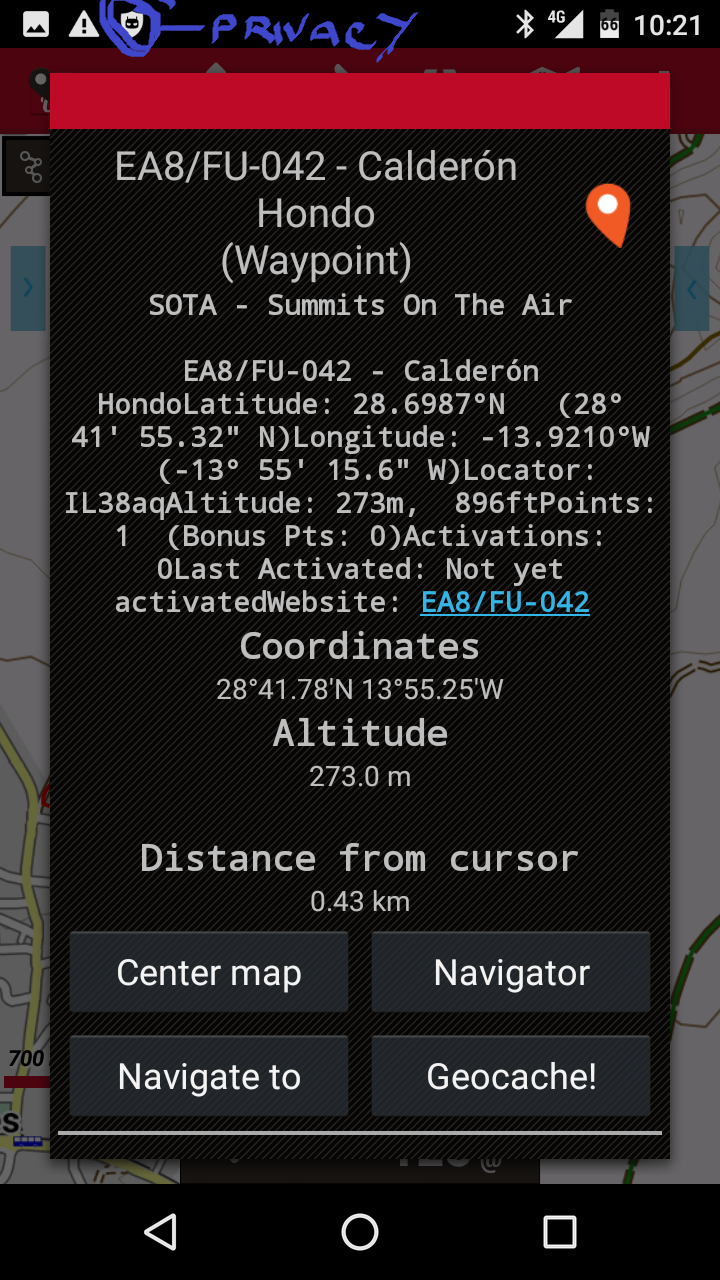
And here is a the data contained with each summit location. I’ve marked the extra PrivacyGuard icon to show it’s modifying the apps permissions.
The great thing is the app is free. The maps can be accessed either online or you can download them and are free. The SOTA overlay comes from Rob’s Sotamaps website. It intergrates with the phone’s GPS and whilst there are lots of options and the app is a bit daunting to use at first, it works very well. I’ve found the crowdsourced maps to be extremely accurate when used for SOTA in SP, OK, ON, LX, PA, DM, F, EA8/LA and EA8/FU.
2 Likes
I didnt know that I could get the summit data for Oruxmaps!!! Amazing!
I recently added the OS Explorer 1:25000 to Orux too (small parts I need each time). Amazing app.
You go to the Sotamaps main page and click the Export… button underneath the list of summits then select the association and the format (KML) and it generates a file for you to download and use in Orux. ISTR you need to unzip the KMZ Sotamaps creates to a KML for use.
1 Like
As the OP requested grid data and did not mention maps I would recommend OS locate.
You can switch between National Grid and Lat/Long in the settings.
Useful compass that can be overlayed over your paper map.
I used the same method to add all DM and DL summits to my in-car navi! Very useful function the KML export!!
Ed.