It seems a change in careers, some increasing health issues, and life in general has moved me away from SOTA. But the last few weeks we have been asked to practice “Social Distancing”, and the control room is now limited to the on-duty crew, everyone else stand by at home. So I’ve become a little more active of late. There is talk of a control room lock down, and as a senior operator I expect to be called up. But so far El Paso has been relatively virus free. The recommendation is groups no larger than 10, restaurants only allowed 1/2-capacity, and social distancing. So a lock-down of the electric utility control room is not imminent. Yet. Sunlight and exercise away from others is being encouraged (UV light kills it). Sounds like a summit to me!
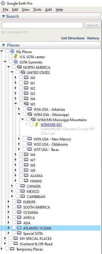
Trying to get a grasp of all the changes. One thing that seems to have slipped away was the Google Earth .KML file. As I recall, before the demise of Yahoo Groups, there was a Yahoo Group called SUMMITS. Within that group was a file that was sometimes updated called Summits.kml. If possible, I’d like to rediscover where the file is available now. I find Google Earth quite valuable for activating and chasing, but I today discovered my present file is nearly a year out of date. Any direction to that file much appreciated.
Regional KML files of the particular area you are interesting in can be generated from the SOTAMaps site here - https://www.sotamaps.org/ (or linked to from various SOTA websites).
I still produce this file as part of my normal workflow, but both of the places that I used to upload it to have gone away.
However, I no longer think it is useful for its original purpose. In my experience, Google Earth just cannot cope with so many points. For a while I thought the problem was my tired old home computer. However I have now upgraded to a fairly serious machine (10 core, 64GB, NVMe flash disc) and Google Earth still chokes on summits.kml. It no longer brings the entire machine to a halt, but Google Earth itself becomes almost totally unresponsive for long periods. It seems that the sheer number of summits overwhelms it.
My script does support generating a file for a subset of summits, but I cannot easily expose that function publicly.
Meanwhile, as Ed pointed out, we have the SOTA mapping project which can produce customised KML files. That didn’t exist when I started making my file, though it sounds from other threads like it may itself be under threat.
I can mail you a summits.kml or summits.kmz if you like, but to be honest I don’t think you will find it useful.
Actually, I find that file to be very helpful in places where I have no internet. And to keep it from slowing the system (wife made me upgrade to a monster Win-10 desktop so it hasn’t been bad), I just leave everything unchecked until I need it. That has worked out superbly for me.
What prompted me to search for the file was I saw an activation for an XE station, and the .KML file I presently have did not contain the XE data.
I would very much appreciate having that file. Download, E-mail, whatever is easiest for you.
We just dumped a 150 MW generator - gotta go. TU. Mike-KD5KC.
Thank you for the file. This is how I set it into Google Earth, and by only selecting the summit or the group of summits I am looking at, it is not a burden on the system resources.
Once again, I do very much appreciate an updated version. MEXICO has SUMMITS !!! I wonder what I need to do to activate any. I guess I need to contact my old Army friend Jeryl. He is always inviting me to visit.
Hi Martyn,
I would love this file also, mine is dated 2015, and my 12 core machine loaded all of (then) North America in seconds. Really love using GE to explore for new summits.
Why not switch to SOTLAS? It is a modern and fast tool dedicated to SOTA, provided with useful features, dynamic links to anywhere and some data download possibilities.
Thanks. Maybe it is my ineptness, but I find it very lacking in base maps, some useful features, but my least favorite of the mapping options.
Doug W1DMH
I am still not convinced that it is really useful any more. I have a pretty powerful machine (10 i9 core, 64GB RAM) and I still find that Google Earth tends to choke on this file. It seems to be better if I turn off visibility of the points immediately after starting and just turn on the ones I am interested in. Would it be better if I set the points not visible by default? It’s a trivial change - crossing out code in fact since I’d no longer need to treat deleted summits differently.
I really like SOTLAS, amongst many things, the interface works well on a mobile.
After what I presume is a recent change to SOTLAS, is there a way to completely make summits I have activated disappear from the map (like it used to, rather than smaller dots?)
73 Matthew M5EVT.
–edit-- I see it has now been modified again - thank you!
a) include Andorra
b) change all the points to invisible by default (i.e. you have to tick the regions you want to see).
The latter change makes the performance acceptable, for me at least. If you really want it to show all the summits, you can just tick the “Current” folder (and Google Earth seems to behave a bit better if you zoom in to the area of interest before doing that.
I thought about doing what Martyn has done, but he is absolutely right - Google Earth is not good with lots of features in your project file.
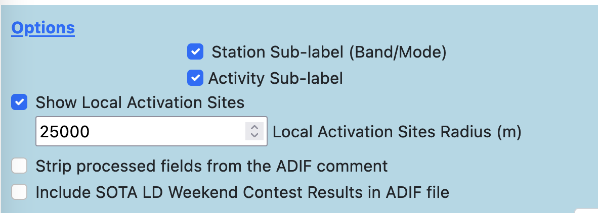
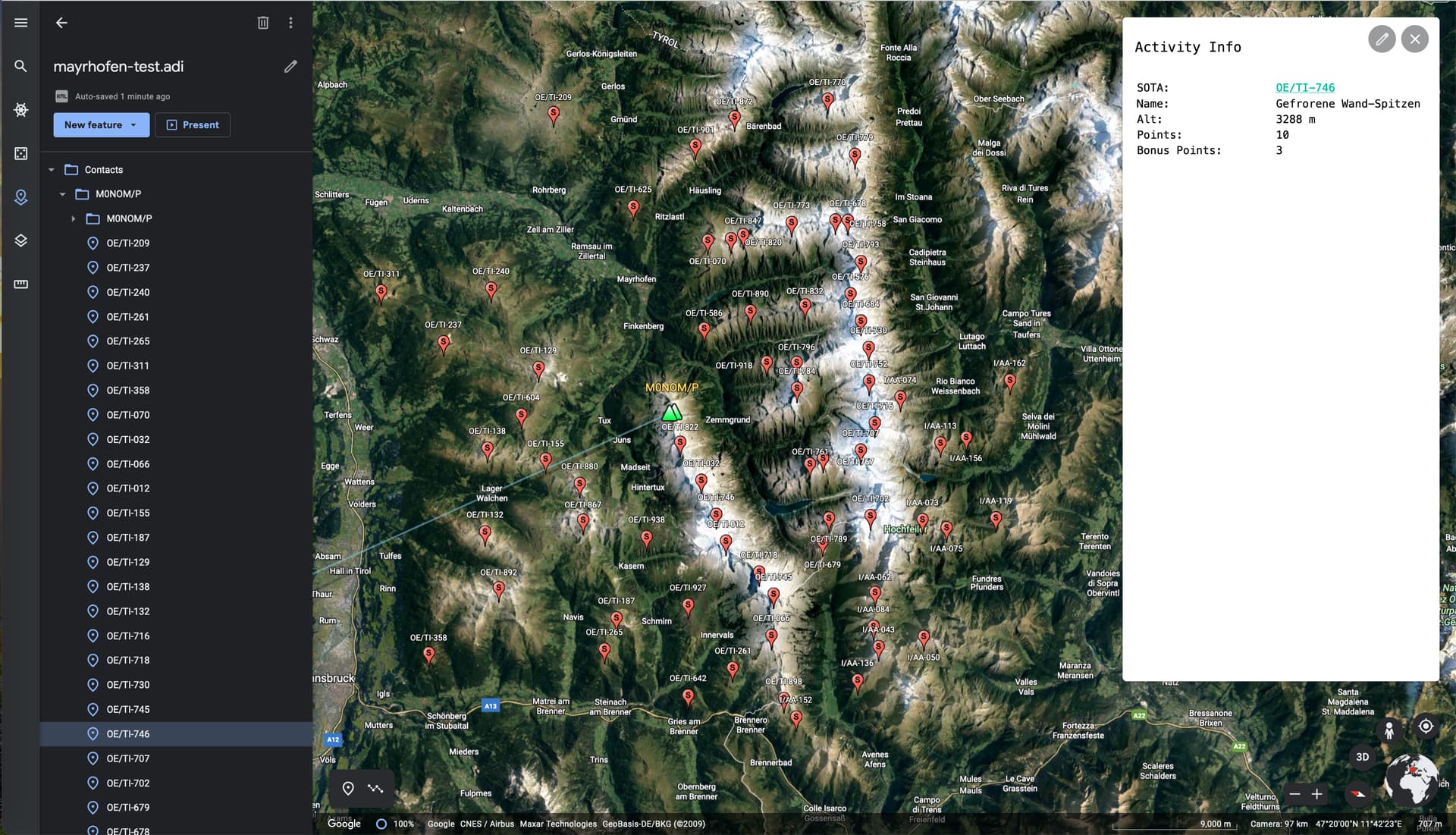
In order to combat that somewhat, I added a feature to the ADIF Processor to allow you to explore an area of interest, which might help you with the overload.
You create an imaginary contact from your location on a SOTA summit in the centre of the area you want to explore. Using a SOTA CSV file this is trivial, for example:
Note the summit reference OE/TI-843. Everything else is irrelevant, as long as the file is well formed. Then process that file with the ADIF Processor using the Option Show Local Activation Sites with suitable radius:
I have just discovered the Summits file. Thank you Martyn! It works with no problems at all. Being able to ‘switch areas on and off’ is great. I am using a MacBook Pro with a M1 chip and everything works seamlessly! No stuttering or anything…I just lost an hour of my life planning a route in France. I might never leave the house again, how many points for Virtual summits?