Is anyone else having issues with the graphical elevation profile that is shows when displaying GPS tracks? I’ve noticed that the elevation profile, while graphically correct, shows incorrect start and end altitudes. For example, W4G/NG-004 shows what appears to be a 250’ elevation gain. In reality, it’s more like 1400’. The starting elevation shows 600’, but the trailhead elevation gain is closer to 3150’.
As far as I know the accuracy of the satellite data varies a bit depending on the latitude.
73 Joe
My understanding is that GPS tracks are loaded by activators who have recorded their track on the ascent of the summit. As opposed to plotting a track over the terrain from point A to Point B (which is generated within the mapping system from the NASA and other data), GPS tracks will only be as accurate as the GPS file produced from the recording device and I wonder if what could be happening is that one system is working in feet while the other is in metres?
This is just a couple of thoughts - it’s highly likely that I’m completely off.
If you are looking at one of the GPS tracks submitted by KI4SVM for this summit, it’d be good to see if he is seeing the same errors that you are.
73 Ed.
It looks like the height data is coming from the track uploaded not the map. For the summit mentioned there are 2 tracks arriving at the same point. But they give different heights. The track data must be wrong in some way (for various definitions of wrong).
Hi Richard,
looking at the GPX file itself it seems to have some errors in it rather than it being a problem in the SOTAmapping feature.
This appears to be a problem just with this track file for this summit - or have you found any others?
73 Ed.
Pretty much every track I’ve looked at in SOTAMaps W4G has a bad elevation profile. The profile graphic is essentially correct, but every elevation value is wrong. I thought it was displaying meters at first, but a quick calculation ruled that out.
I’ve found bad data in:
W4G/NG-022
W4G/NG-023
W4G/NG-048 (two different activators - Same issue)
I’m going to try to upload some known good GPX files this evening and see what happens with them.
Thats a great idea Richard if you can upload a known good GPX file and see if it somehow corrupts.
All the summits bar one GPX track, you have listed with the error have tracks from KI4SVM so there could be a common problem here, either in process or perhaps in the unit that Patrick has?
Patrick @WW4D - if you monitor this reflector, can you add anything to the mystery please?
73 Ed.
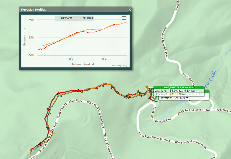
I don’t think it’s an error with Pat’s GPX files. I just uploaded a known good GPX file and it got corrupted in such a way that it almost exactly matches Pat’s uploaded file. Too big of a coincidence for both of ours to be bad original files. This is W4G/NG-027
Could it be an issue with the sampling routine?
Agreed - thanks for doing the test.
Now I’ll step back and let people (far) more knowlegable than I investigate further.
73 Ed.
1 Like
Should be fixed now. There was a wrong conversion ratio between Feet and Meters (accidentally set to km to miles ratio). Probably been like that from the get go.
Woohoo! Thanks! I know it’s been that way since I started back in August. I seem to remember raising a ticket through the online form back then but never heard back. Surprised no one else has reported it. Anyway, all is well that ends well. Looks like it’s good to go.
Thanks again for the quick resolution!