Is this a future function, or do I just not no how to use it? Thanks for the great app.
Doug de W1DMH
Is this a future function, or do I just not no how to use it? Thanks for the great app.
Doug de W1DMH
HNY Doug! These functions are greyed out for me also. I suspect they are not yet active but forthcoming soon, as Rob/DM1CM is very active with adding new capabilities. BTW, this will be a great function. I think this capability was asked by Fred/KT5X and will be helpful for “uniques” chasers.
Guy/n7un
Thanks Guy! HNY. Thanks for the reply. I am usually doing “unique to me” summits, and usually “firsts” so this is a fantastic function for me. Can’t wait!! Hopefully I will be able to include my “old” call sign.
73 Doug W1DMH
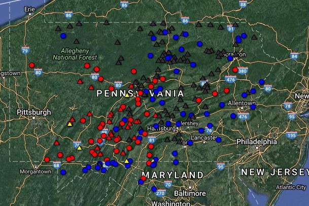
Doug its relatively simple to create your own map using the functions is GPS Visualizer…
You can download the summit list, color the items using your own color code and create simple maps… like this for me / W3
Red is my activation, triangle denotes first activation
Black is not-activated by anyone
Blue is previously activated (not by me)
Yellow denotes inaccessible summit
Hi Richard,
Ok. I downloaded the .kml file for the Assoc/Region. But how do I in GPSvisualizer change the icon and label data as you did? I don’t see it or your changes are not obvious to me in GPSvisualizer…
Guy/n7un
Sorry, I over simplified… it took me a few gos to get what I wanted (you’ll find a thread on this somewhere on this reflector)
Go to the summits database… SOTA Database
Download the list of all summits… push into a spreadsheet
I used column headings… “name,full desc,color,symbol,alt (feet),latitude,longitude, date, points, desc”
Complete the field updates per your logs.
Save as a CSV file
Upload to GPS Visualizer
Cool but seems a lot of work. May just wait until the function gets activated.
Doug
W1DMH
Doug, I started doing this a while back since my earlier inquiry ended with the advice from the MT that the SOTA site and Mapping site were not linked and so the “what have I done” and “what do I have left to do” feature would not be happening anytime soon. I’ll drop this in heartbeat when the detail is integrated into one of the SOTA site.
Once you have it up and running its not difficult to make updates… for instance for last w/e I completed three peaks.
I opened the csv file changed the lines/summits concerned from BLUE to red and then opened GPS Visualizer and uploaded the csv, Saved the HTML map and I’m all updated… probably took 3mins…