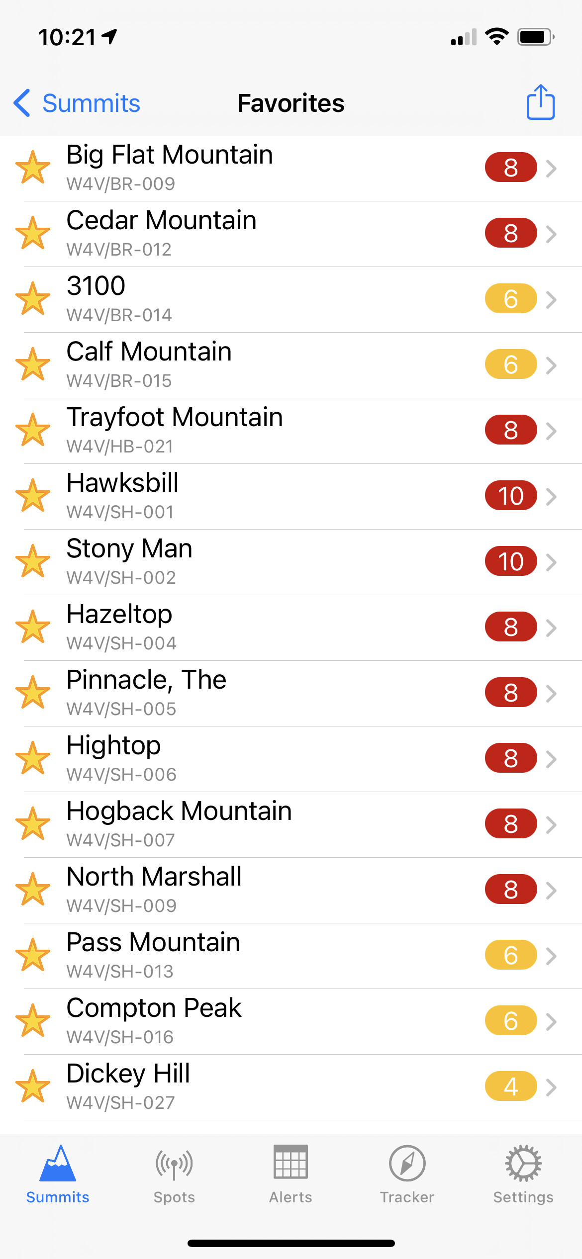
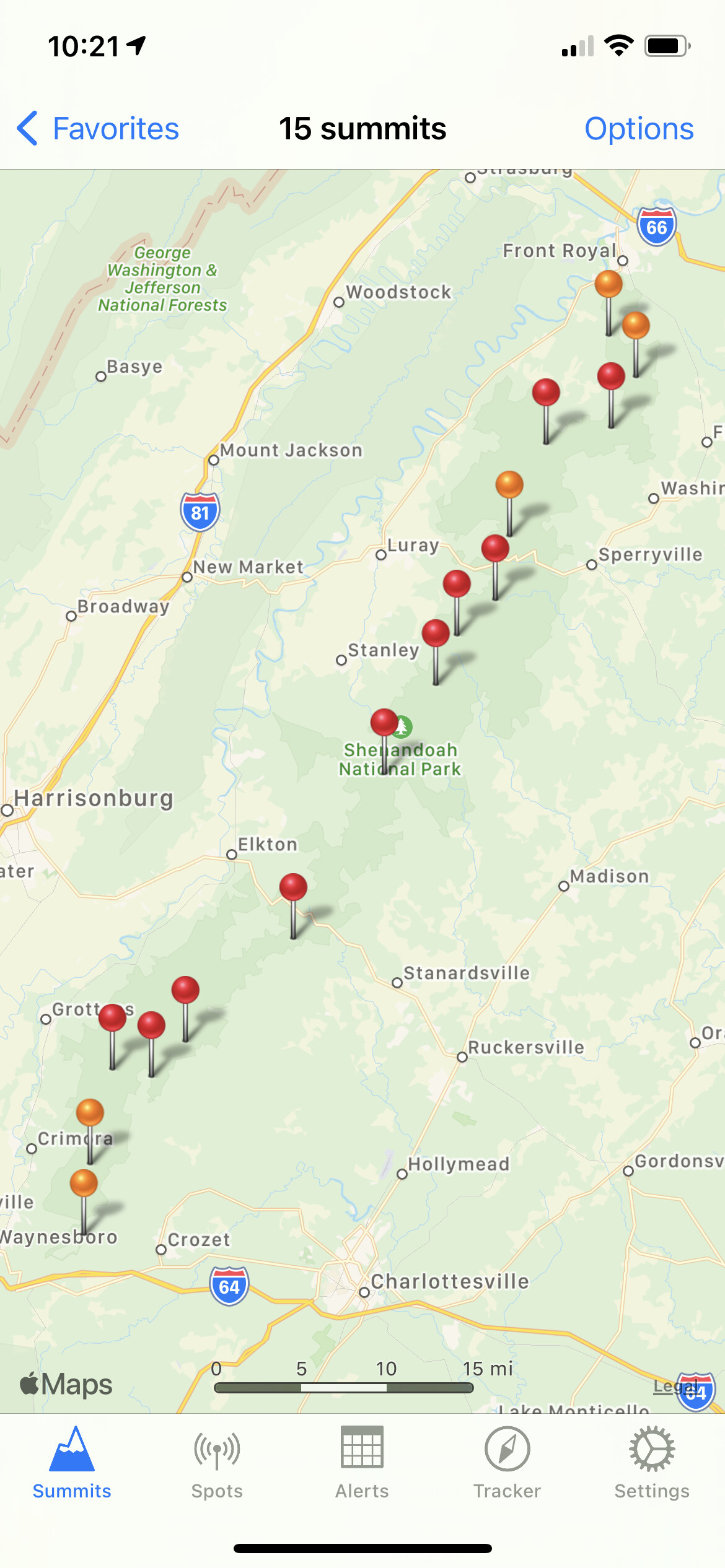
I thought I had posted here before but apparently I did not. Either way here is a week and half heads up that I will be doing or trying to do a bunch of summits. Will leave my house the morning of 18 August. Will more than likely do a summit or two that evening. I will have my FT891 and FT60R with me. My truck will be sending APRS data as Kh7FC-9 and then my person will be KH7FC-7 . I will post alerts from the hotel and hopefully will be spotting once on the summit. I will be working this from Front Royal and going south.
I know it’s a large list again but I think I have a better chance with this list since they are closer together than my May list was. Either way hope you get you in the log.
Looks like a good list. I have completed many of those this past winter and if you need some info, click on VA in the state map on my website and you will find many of my trip reports. May give you some ideas, etc.
Have fun.
Your reports are what I based my idea of doing this over a couple of days. If I get all of them awesome if not that’s ok too. I really want to get as many as I can before the NAQP SSB starts on Saturday lol
Looks like a fun SOTA outing! I’ve done most from Hawksbill North. Most of those are short 20-30 minute hikes up to the summit. I plan on Hawksbill South in October. If you can fit Apple Orchard Mountain in there somehow it’s worth the effort.
I think I can hit most of those on 2m from my house (HF will depend on propagation and band). I could even pop out to some of the summits on the northern end of Skyline for a S2S while you work the southern to middle portions.
BTW, if time allows, from Dickey Hill, Blue Mtn is only about 20mins away and is a drive up summit (there are hike-up routes too, but I’ll assume you want a drive up option). Blue Mtn is not VHF friendly though, so plan on setting up your HF rig.
Looks like I will pass blue mountain on the way to the hotel on Wednesday that might be the first one I do then. I won’t turn down any contacts and S2S would be even sweeter.
That makes it easy then. Let me know if you need directions for the drive-up option.
BTW, if you do POTA, you’ll be able to knock out 3 POTA references on your trip (Shenandoah NP, Appalachian Trail, and if you do Blue Mtn, Thompson WMR).
I am into POTA , thanks for the info. Drive up from the map looks straight forward. Unless I’m missing something. I drive a 4wd Colorado also if that helps
Basically, you’ll drive up Freezeland Rd to 38.95792442462494, -78.02354120789272, then turn right onto an unmarked gravel access road for a hundred yards or so. That’ll take you right to the summit. Keep in mind, during the working day, there “could” be crews there to work on the radio towers. I’ve only run into that once, so it’s not a common occurrence.
If you fancy a short hike, you can park at the Trillium Trail parking area just before the coordinates above and take the trail up to the summit. It’s about a quarter mile hike, maybe less.
Again, this is not a VHF-friendly summit due to the FM radio transmitter and the other towers hosting who-knows-what. HF works fine though. I’ve never had a problem on 20m or 40m and there’s plenty of space for antennas.
You might notice Naked Mtn is nearby as well. Don’t bother. It’s on private property and is a bushwhacking slog for 1 point (I approached from a different direction and didn’t know it was private property until I came across the signs on the way down the opposite side).
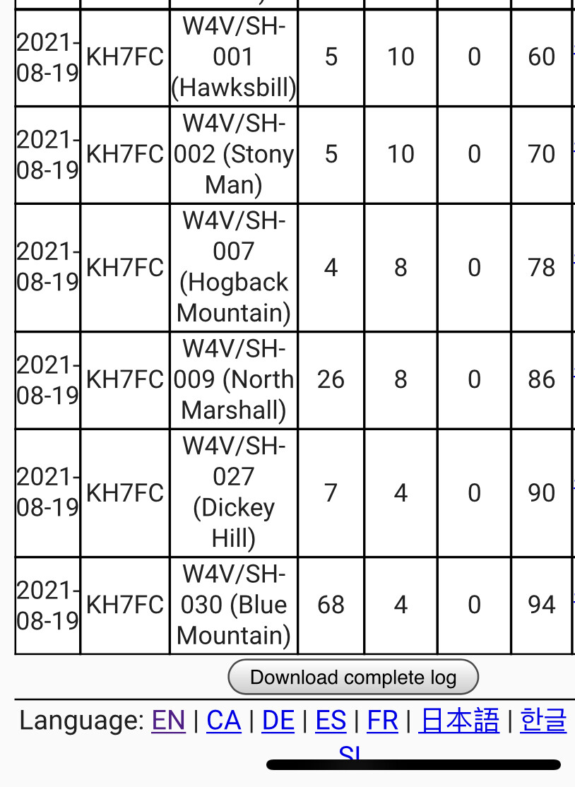
Wow what a run yesterday, we did 44 points in a UTC day. With 6 summits, it was great fun. I want to thank AG4VA and K1HTV for all the help. Had to come a lot further out of the park than I wanted for a room. Also weather does not look promising today. We are going to take it easy and hit some other sites in the area. I have a bunch footage to edit and logs to turn in.
Gotcha. Yeah, mo’ power and POTA will do it every time. I’ve long been surprised by how much more interest I can raise by activating via POTA compared to SOTA. In most cases I’m in the same location using the same station.
Me: “CQ SOTA”
Me 5 min later: “CQ POTA”
<here comes 10 stations in response>
If you haven’t hit Compton yet, the summit is just before a really nice overlook. Walk another 5 minutes past the summit to see it. Unfortunately I’m sure that view is outside the activation zone (but you could run a Shenandoah NP POTA activation there!).
Super post–I’m glad that I stumbled upon this. After activating a number of peaks in the Adirondack Park region this summer, I’ve come to really appreciate the Skyline Drive. Hiking in 1-2 mi and up 500-1000’ is basically a drive-up summit when it comes to sister peaks in other regions.
But I am after some points. There, I said it. Plan is to try to take a day or two off during good weather from 1 December this year and in 2022 before 15 Mar 22. That should help maximize the points.
I figure that I can probably activated 3-5 peaks in a day given road travel time, hike in/up, setup, operate, tear down, and return to the car. I normally run CW, but frankly don’t know how that might go as the fingers get cold…
This seams doable for W4V/SH, a little less so for W4V/BR, and difficult for W4V/HB.
Yeah I wanted to get more done but we still had a good time for sure. I’m sorry to inform you though, new regulations says that Army guys aren’t allowed in the park after thanksgiving. Hihi. Nah just kidding hopefully I can be home on the shore and get you in the log. There are other summits in the state that are actual drive ups. If you want to see what my hikes were like go check out my videos for the activations on your tube.