Welcome home 73 John m0hem
Welcome Back! I just came back after 1 year of being away from home and the mountains and it is so nice to get back out, you guys are going to have so much fun.
73 De VE6JTW
2 Likes
More detail on the Knott activation
The day was forecast to be hot, though not as hot as further south and there was a nice sunrise. Our target for our first SOTA activation in 42 months was Knott G/LD-023 starting from Apronful of Stones. Given the projected temperatures we worried about taking enough water with us. As we drove the relatively short distance from the holiday cottage, we could see clouds hanging in the valleys. Caroline made the mistake of navigating Martyn along the gated road through Low Mill and got her first exercise of the day repeatedly getting out of the car to open and shut multiple gates!
Since our last outing we had replaced out previous SOTA rucksacks which had been coming to the end of their life, so were still working out how best to attach kit to the new rucksacks. Caroline needed a different arrangement for the Kenwood TH-F7 handheld and rucksack antenna that she uses to monitor 2m and 70cms calling channels when on the hills. We got our kit attached to the new rucksacks and set off, initially passing former quarry areas and climbing more steeply around the crags of Scurth. It was not too warm under the clouds but humid and we were soon sweating profusely as we made our way slowly up the steep path heading up Carrock Fell. Part way up we emerged into bright sunshine and started overheating. The clouds came and went, and we were glad of the slight breeze when the gradient eased. It took a while before the fine cairn on Carrock Fell appeared. There were good views from the top and we heard Andrew g4vfl activating a trig point for WAB and gave him a call, which caused Geoff gm4wha to ask for a WOTA contact, duly given.

Steep climb!

Carrock Fell

View from Carrock Fell
We continued over mostly gently undulating hills, some slightly boggy, to join the Cumbria Way, passing the Lingy hut. We left the Cumbria Way to climb more steeply up the flank of Knott and the more gently follow the ridge to the summit cairn, getting some views of Blencathra and Skiddaw when clouds permitted.
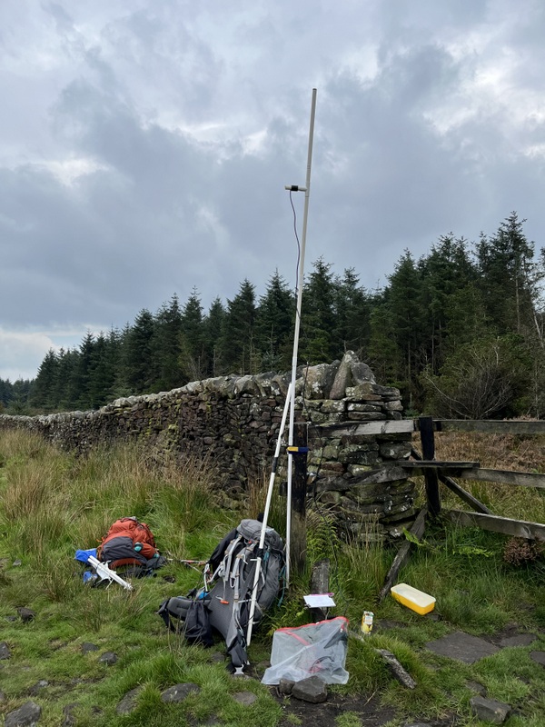
The summit is fairly flat with no shelter. Martyn set up the HF dipole a little way from the cairn away from paths and Caroline set up by propping the rucksack up against the cairn with walking poles and attaching the dipole above the rucksack antenna pole. We used our normal technique of Martyn starting on HF and Caroline on 2m FM and also trying to get 70cms contacts. Martyn only got 2 contacts on 5Mhz but did better on 7Mhz including 2 S2S which Caroline grabbed too. Caroline ended up with 10 on 2m and 4 on 70cms.

2m and 70cms station on Knott

HF station on Knott
We were later than hoped packing up and starting our descent east along the ridge over Coomb Height. There were good views in what was turning out to be a lovely evening. The path got narrower as it descended but was generally reasonable until we were within about 50m vertical of the valley bottom when we hit horrible bracken which was really unpleasant.

Blencathra from descent of Knott

Skiddaw from descent of Knott

Skiddaw from descent of Knott

Descending Coomb Height

Nasty bracken at base of Coomb Height.
By the time we had fought our way through the head high bracken to the valley bottom track we were very hot. We found a little flowing water to splash ourselves with to cool down and stones to sit on to consume apples. There was then a pleasant valley road walk with nice evening light to Mosedale where we spotted a historic but still functional Friends Meeting House. Another road section with lots of Herdwick sheep brought us back to the car at around sunset. A lovely but exhausting day.

Valley Road

Mosedale Meeting House.
8 Likes
Activation of Little Mell Fell G/LD-037 on September 11th 2023
Our legs (thighs) were a little stiff following our first non-trivial hill ascent and activation in 3.5 years on 9th September, but not enough to prevent another hill ascent on 10th. Instead it was the weather forecast of serious thunderstorms in the middle of the day that caused us to avoid the hills. The day started quite brightly and the Mell Fells were looking very appealing as we resisted the temptation to climb them in favour of a lower level walk in the Penrith area. Our low level walk took in two prehistoric henges, a fine ruined castle, earthworks from a roman fort and a Millennium memorial. Our decision was validated when the rain and thunder started around the midpoint of the walk at Brougham Castle, and we ended up eating our lunch sheltering from the torrential rain and almost continuous thunder in a corner of the castle.
The forecast for 11th was for a dry but cloudy morning with rain reaching the area around lunchtime. We decided that this should give us time for a quick activation of a Mell Fell, and chose Little Mell Fell because of the shorter walk, allowing us a quicker exit should the weather turn suddenly. We drove to The Hause where the parking was fairly full, but we squeezed onto the end, but while we were togging up the car in front moved, so we could get properly off the road: result!
Given the forecast we decided to leave our packed lunches in the car and headed up the roughly northerly pretty straight up path and before long the stone built trig point appeared in front of us. It was cloudy with the clouds hugging the tops of the higher fells, but we had some reasonable lower level slightly misty views. The trig point was surrounded with water, and since this fell is often busy I set up VHF in a little dip away from the trig point. With Martyn setting HF a little further north away from the paths.

Ascending Little Mell Fell G/LD-037

Little Mell Fell G/LD-037
As expected, it wasn’t a good VHF site, but Caroline qualified the hill with 6 2m FM contacts but could only raise one 70cms contact from the ever reliable g(m)4wha who she worked on either or both of 2m and 70cms on all the LD summits of the tour. Martyn started with 5 5MHz contacts to qualify the hill. He then moved to 7MHz which was the start of a 5 HF S2Ses for both of us. First was Colwyn on GM/CS-120 on 7MHz after which Martyn ran another 20 7MHz contacts. We were past the time of the forecast rain but there was no sign of it, so Caroline decided to try 14MHz which yielded another 3 S2S (HB9BQU on HB/GE-349, F5AOL on FL/VO-031 and Lutz DL3SMA on DM/NW-185 as well as 14 other contacts. A 7MHz spot for Alan MM1FHM on Goat Fell GM/SI-006 provoked a band change for a compete for both of us. With still no sign of the rain Caroline tried 21MHz, but it only yielded 2 contacts: Finland and County Durham!

Little Mell Fell G/LD-037 HF station

Little Mell Fell G/LD-037 Minimal VHF station
It was well past lunchtime, and our stomachs were complaining about the lack of lunch, so we packed up, deciding to take an alternative path down, initially east and then contouring round to The Hause. A few spots of rain arrived as we descended and it got heavier as we ate lunch in the car, but we had been able to have a much longer and more satisfying activation than anticipated.

Descending Little Mell Fell G/LD-037

Descending Little Mell Fell G/LD-037
5 Likes
Thanks for your terrific report and great photos. Well done.
Geoff vk3sq
1 Like
Tuesday 12 September 2023: Activation of Blencathra G/LD-008
The MWIS forecast suggested that it was going to be a reasonable day on the hills with occasional showers and some cloud on the high tops early but clearing later. We decided to risk a reasonably big one and chose Blencathra as it was closest to the cottage.
We chose to do one of the longer approaches, which avoided any exposure, starting from Mungrisdale. Research had suggested that there was honesty box parking by the village hall, with roadside parking a little further south. We attempted to approach Mungrisdale from the south to minimise the amount of single track road, only to find “Road Closed ahead” when leaving the A66 for Mungrisdale, so had to turn round and drive almost all the way back to the cottage to take the northerly twisty single track road approach. At the village hall we were met with confusing signs: some indicating that parking was £2 with instructions of where to pay and others that parking was for village hall users only. We continued past it to find the roadside parking with just a couple of spaces left, turning round we grabbed one of them, togged up, put £2 in the honesty box and set off under clouds with damp in the air.
A footpath took us over a little bridge and up to a gated road which we followed through a gate before looking for a path through the bracken angling up the side of Souther Fell. As we ascended the damp turned to drizzle and turned to enough rain to require application of waterproofs and rucksack covers before we reached the ridge line. We eventually gained the ridge just south of the summit of Souther Fell. The ridge dropped down towards col at Mousthwaite Comb, the rain eased, and we got views of the flanks of Blencathra though the summit was still in the clouds. The weather slowly improved as we ascended Scales Fell towards the summit of Blencathra, but the top was still in the clouds when we arrived.

Blencathra in the clouds

Ascending Blencathra

Summit in the clouds

Summit in the clouds
We set up a little way north of the summit to avoid the regular procession of people visiting the summit, Caroline a little higher than Martyn for the VCHF station. The clouds lifted during successful activation in the dry, with 10 VHF and 6 UHF contacts for Caroline and 8 5Mhz and 17 7Mhz for Martyn. There was a fresh northerly breeze and by the time we had had our late lunch we were cold and needed to be on our way to complete the walk, so didn’t do other bands.

Operating VHF station

Operating VHF station

Views once cloud cleared

VHF station

HF station
The clouds had lifted enough by the time we were leaving for some good views and conditions improved as we returned via a lovely set of ridge walks. We headed north over Atkinson Pike and the round to the summit south of Bannerdale Crags and the over Bowscale Fell where we found a little shelter to stop to consume apples on a lovely evening. The ridge back east was lovely except for a final steep section on a narrow slippery path through bracken and gorse. Back in Mungrisdale we passed the tiny church and lime kiln remains on the way back to the car.

View of Sharp Edge on descent

Descending Blencathra

Descending Blencathra

Descending Bowscale Fell

Souther Fell from descent Bowscale Fell

Mungrisdale church

Mungrsidale Lime Kiln
6 Likes
Wednesday 13 September 2023: G/LD-003 Helvellyn
The MWIS forecast was for a generally good day on the hills, but with increasing winds late afternoon and the possibility of some showers later, so we decided to risk a big hill and chose Helvellyn. We had done it twice before for SOTA (and pre-SOTA). The first time we did it with Seat Sandal in nice conditions but was also memorable for Martyn’s GPS having become detached, picked up by another walker who contacted us and allowed us to recover it later. The second time was Martyn’s mountain goat activation, memorable for being done in nasty rain and wind as that September day was our last opportunity to get up a hill that year.
The day started sunny, and we had excellent views as we climbed up from the Wythburn car park (£8 all day but worth it if as claimed it goes to maintain the hills). As we climbed up through the trees, Martyn’s GPS became unclipped and dropped off: thankfully noticed by a passing walker (a different GPS from the earlier ascents). He tried attaching it in a different way but further on it fell off a couple more times, Martyn eventually finding a place to attach it where it seemed more secure, but we both needed to keep checking it was still there! What is it about Helvellyn and our GPSes?

Ascending Helvellyn

Ascending Helvellyn
We were overheating in the sun and were glad of the breeze when we emerged onto more open ground. As expected, the paths were busy but not ridiculously so. The summit was clear of clouds, so we had views. There were lots of people at the summit, so we moved slightly down on the west to set up. Caroline got 14 VHF contacts and 6 UHF plus a 7Mhz summit to summit with DJ2TG on DM/NW-078 Heidbrink on Martyn’s station. Martyn got most contacts on 5Mhz finding both 7 and 14 poor.


VHF station

HF station

VHF and HF stations
It clouded over and the forecast winds appeared on the summit sooner than anticipated and we both were feeling the cold despite many layers: 5 on body and 3 on head for Caroline. So we packed up and decided to descend via the Helvellyn Gill path for a circular walk. Part way down light rain started so we stopped to apply waterproofs, but the rain later stopped for long enough for an apple eating stop.
Descending Helvellyn

Descending Helvellyn

Descending Helvellyn

Looking back when descending Helvellyn

Helvellyn Gill
Having used the toilets at the Swirls car park we realised that we had less than an hour to sunset and still a couple of miles to walk through the forest to the car! Thankfully the permitted bridleway through the forest provided good walking and some decent views, though it undulated quite a bit, and we were back at the car just after sunset. Only about 7 miles in total but a lot of up and down. A long, exhausting but good day on the hills.
8 Likes
Hi Caroline, what a great report with photos. Well done. ![]()
Cheers to you. ![]()
Geoff vk3sq
2 Likes
Thursday14 September 2023: Skiddaw G/LD-004
The MWIS forecast suggested that it would be mostly cloudy with the tops mostly clear of clouds, and mostly dry but with possibility of light rain showers. We didn’t want to have too long a day as we needed to get back to the cottage to tidy up before leaving the next day. We’ve climbed Skiddaw previously both for SOTA and pre-SOTA, a couple of times via the tourist route from the SE (easiest with a higher start), but some more interesting routes from south and west. The most interesting was up over Ullock Pike and back down over Cockup, but this time Caroline planned a route up from Dodd Wood, over Carl Side, and with a return over Ullock Pike and back through the forest, with the option of a shorter return via the ascent route.
We drove to the Forestry England car park at Dodd Wood, which surprised us as being pay and display on exit, but with no need to get a ticket on the way in – all done with number plate recognition. It was cloudy but dry as we togged up and headed up on various forestry tracks on the north side of Skill Beck, getting quite warm on the steady ascent. At the top of forestry, we found a stile out onto the open heathery fell and a narrow path continuing upwards. At one stage the path had partially fallen away down the hill, and we had a bit of an awkward clamber over some slippery rocks to get past it. We reached a ridge line at “White Stones”, and decided we needed to remove a layer as we were overheating.

Derwentwater from ascent Skiddaw

Derwentwater from ascent Skiddaw

Derwentwater from ascent Skiddaw

Dodd Fell from ascent Skiddaw

Looking down From Carl Side

Looking up towards scree path onto Skiddaw from Carl Side
A reasonable path took us to the top of Carl Side, followed by a slight drop before the final scree climb onto the main ridge of Skiddaw. Clouds were now gathering just above the top of Skiddaw, and it started to rain as we picked our way through the scree: not a suitable point to stop to apply waterproofs, so we had to continue without until we made the ridge. The wind was now picking up and hit us when we got to the ridge. The main summit shelter was occupied but we carried on beyond the trig point to find a smaller shelter a little further along. We settled in and Caroline decided just to try using the rucksack antenna propped up against the shelter as the dipole was unlikely to stay up in the wind. Martyn set up HF slightly down on the slightly less windy side, but it was too windy to operate outside the shelter, but we managed to operate without conflicting with each other.

Summit trig before clouds descended

Summit trig and toposcope before clouds descended

Summit view before clouds descended
Caroline had managed to qualify with 7 contacts on 2m FM and 4 on 70cms FM before Martyn had the HF antenna up, though he had grabbed two 2m FM contacts as insurance. He then qualified the summit with 7 on 5MHz, including S2S with G3TQQ Dave and G4OOE Nick on G/TW-003 Gisborough Moor. He tipped them off that Caroline had heard them calling CQ on 2m (almost the opposite side of the country with the Pennines in between), so they tried 2m again and contact was made, even though Nick only gave her 33. A move to 7MHz brought a S2S with James 2E0VJT on G/CE-001 Cleeve Hill. Martyn then continued on 7MHz with 10 contacts while Caroline ate lunch. With the weather deteriorating, Caroline took over on 7MHz while Martyn ate his lunch, getting another 14 contacts. A final 2m call got her one more contact, but it was then time to pack up.

HF set up in the wind and mist.

Caroline operating HF with VHF/UHF setup behind.
While packing away things the wind took Caroline’s rucksack over, crashing the attached antenna into the rocks, fracturing the plastic pipe where the feeder comes out. The antenna has had the odd repair in its probably around 15-year life, but this is probably fatal. We packed up the pieces into our various antenna bags and started retracing our steps. Thankfully when I bought the rucksack antenna Martyn also bought one which he seldom uses, so I was able to borrow that for the rest of our SOTA trip.
There was considerable relief from the wind once we had dropped off the ridge to descend the scree path, and we were soon below the clouds and getting views of the lower fells. We didn’t have time for the longer Ullock Pike route, so roughly retraced our outbound route. By “White Stones” we stopped to eat an apple before taking the slightly dodgy path back to the woods. Once in the woods we found a different path on the south side of the Skill Beck. Back at the car park Caroline managed to lose one of a relatively new pair of fingerless gloves, having stuffed them into a coat pocket when using the toilets: one must have dropped out but wasn’t noticed until sorting things out back at the holiday cottage.

Carl Side on descent

Ullock Pike on descent

Misty views of Criffel across the Solway Firth on descent
5 Likes
Friday 15 September 2023: Friday: Fair Snape Fell G/SP-007
We were moving from one holiday cottage in the Lake District to another near Lytham St Annes for a long weekend. The forecast for the Lake District and much of northern England was rain all day, but with a hint that the rain band would move slowly north, with drier weather further south. We had hoped to so a summit in the Howgills or North Pennines on the journey, but that now looked unplayable. We left the cottage in heavy rain but by the time we got to Killington Lake Services on the M6 just before 11, the rain had eased to drizzle and it was looking brighter further south, so we decided to aim for Fair Snape Fell and hope it would be dry enough. Having chased MW0PDV on GW/NW-054 from the services we knew it was dry in north Wales. It was dry when we arrived at Fell Foot around 12:15, but not trusting the weather we ate lunch in the car rather than taking it with us. It was a sufficiently nice day that hang gliders were making us of the winds and take off around Parlick.

Summit of Parlick with Fair Snape Fell beyond

Hang Glider above Parlick
We had planned a circular route but started with the standard ascent straight up Parlick and along the ridge to the trig point and shelter, on the way up chasing MW0SZR on GW/NW-044. At 510m the trig isn’t the true summit but is well within the activation area of the 520m summit, and a much less boggy and more comfortable location with a better VHF takeoff than the true summit). The substantial summit shelter has 4 compartments, one of which was occupied by what looked to be a group of youngsters being taught navigation when we arrived, but being otherwise reasonably quiet we made our base in one of the others. It was luxury accommodation with a bench as well as rectangular walls to prop the VHF/UHF antenna against. Martyn moved a little way away down the hill away from paths to set up HF.

Precarious cairn on Fair Snape Fell

Summit cairn and shelter

Summit shelter and trig point

HF station

Fair Snape Fell

VHF/UHF station: luxury accommodation.
There were 3 S2S for both of us: two on VHF (G4TGJ on G/SP-014 Longridge Fell – we could almost shout across the valley, and M0RWX on G/LD-001 Scafell Pike) plus DK1ZX on DM/BM-063 on 20m. Martyn also got a 40m S2S with DL3SBA on DM/NW-187, but Caroline missed that one but did well on VHF (17 contacts) and UHF (8 contacts). Martyn got a solitary contact on 5MHz but did better on 7 and 14, but just one on 18MHz. Having done several bands, we had spent too long at the summit for the longer circular walk we had planned so went almost directly back to the car, but round the flank of Parlick rather than over the top.
6 Likes
Beautiful countryside.
72 de VE6JTW
2 Likes
Saturday 16 September 2023: Pendle Hill G/SP-005
The forecast was for a mostly dry but cloudy day, brighter later and with the clouds above the local hills, so we decided to aim for Pendle Hill with the option of doing Easington Fell afterwards. We decided against the “tourist” stepped path from Barley Lane and suspected that the small parking spot on Pendle Road might be full on a Saturday. Instead, we decided to do a longer route from the village car park in Downham. We had a bit of difficulty finding the entrance (it’s on the minor West Road south of the village), but once in got our bearings and also located the village toilets in a converted agricultural building. The ladies are in a fairly conventional arrangement, but the gents are in a converted pigsty with urinals in individual stys.

Downham toilets and information room.

Downham pigsty gents (Photo courtesy of Martyn).
As we loaded up, we realised that the “handy bag” that Caroline uses to carry her Kenwood handheld wasn’t there. With our old rucksacks, the bag with the handheld stayed attached to the rucksack, but that didn’t work for the new rucksack so they were separate. With no handheld there wasn’t any point in attaching the rucksack antenna, but Martyn then realised that he also had a VX7, and Caroline worked out that it fitted in one of the waist pockets on the new rucksack which she hadn’t thought big enough. So with the new arrangement we set off, taking a path by a stream and then slowly ascending through fields. Crossing Pendle Road (where it might have been possible to get a small car in the small parking area) we took the permitted path up into the access area. It was windy, and the cloud was still sitting on the top of Pendle Hill, but it was due to clear, wasn’t it. We continued up the zig zag and into the clouds.
When we got to the wall that crosses the summit (well within the activation area but about 15m below the summit), we decided to stop and use the shelter built into the wall as our base. We couldn’t see the summit (which we knew has no shelter) for the cloud and the wind was whipping over the hill. Caroline set up in one of the smaller compartments, while Martyn moved further away to be clear of paths for HF. Caroline set up the 2m dipole, propped in the corner of the shelter. We quickly had a 2m FM S2S with Chris 2E0YCM on G/LD-024 Pike o’ Blisco. Caroline soon had the summit qualified on 2m FM, but struggled to get 70cms contacts, eventually managing just 3 70cms contacts in 1 hour and 15 minutes (with a total of 11 on 2m). Martyn was doing better on HF, with 8 on 5MHz and 20 on 7MHz, but Caroline was now getting cold, so we decided to pack up and descend.

VHF setup in a short-lived break in the clouds

Operating VHF/UHF

HF setup in one of the clearer times.
We made our way to the trig point before retracing our steps through the access area. There weren’t any views from the summit, which was even windier than our operating position. As we descended, we dropped below the clouds, and we could at least get some views. Having decided we didn’t have time for another summit, when we reached Pendle Road we took an alternative slightly longer route, briefly left down the road and then left along a pleasant footpath along the flank of the hill. It was less windy and slowly turning into a pleasant afternoon. Having passed Moorside farm we headed north towards Worsaw Hill and back to Downham village, even having time to look around the village before heading back to the holiday cottage.

Trig point

Looking back when cloud briefly lifted from summit.

Sheep in a tree.
2 Likes
Sunday 17 September 2023
Longridge Fell G/SP-014 and Easington Fell G/SP-012
The last day of the holiday, and the forecast was reasonable for doing the two nearest one point summits, so this was to be our first two summit day of our return to SOTA. First up was Longridge Fell G/SP-014. We have done this summit several times but always from west from the Jeffrey Hill parking, and we fancied something different. Caroline had noted a parking spot south of the summit on the Old Clitheroe Road, but when we got there the small official parking area was completely full, but there was some unofficial roadside parking a couple of hundred yards back west and we squeezed in there. We started off by walking back west along the road to take a bridleway that passed scattered houses before reaching a poorly defined footpath through access land, which became better defined but muddier when it reached the edge of the forestry. The path came out on the ridge line where we turned right to head to the trig point.
There were people visiting the trig point and we expected it would be busy, so we went past it to find somewhere to setup. Martyn needed to be in the heather to keep the HF antenna away from the path along the ridge, but Caroline found the remains of an old gate, partially fire damaged but still substantial enough for her to lash the VHF dipole to. Caroline had the summit qualified on 2m FM within 20 minutes and on 70cms a few minutes later, ending up with 7 on 2m and 6 on 70cms. Meanwhile qualified the summit with 5 on 5Mhz followed by 26 on 7MHz. With her lunch eaten Caroline took over the HF setup on 20m while Martyn finished his lunch. This produced another 13 contacts including 3 S2S which Martyn grabbed too: LB8CG/P on LA/OL-181 (Feforkampen), OE6NOA on OE/ST-353 (Terenbachalm) and I1WKN/P on I/PM-373 (Monte Bellavarda).

Longridge Fell HF setup

Longridge Fell VHF setup and trig

Longridge Fell trig
Longridge Fell VHF setup
We packed up and returned past the trig point to the path into the forest, but this time took a more easterly path which meandered through the woods to emerge near the roadside parking: a pleasant path, though muddy in the narrower sections. We then drove through Clitheroe to the standard parking for Easington Fell near the cattle grid.
Easington Fell G/SP-012 doesn’t offer many simple route options besides the standard one, so it was down the road to the slightly soggy footpath track heading east, left where it met a wall, and leave the wall where it bends to head slightly left to the summit marked with a small cairn. We decided to head back to the wall to setup stations, with Martyn setting up HF between the wall and cairn, and Caroline setting up VHF propped up against and peering over the wall. Caroline got one 2m FM contact quickly, but then it went quiet, but finding a QSO on an adjacent channel involving one of the people she had worked on Pendle yesterday she managed to get a break in, which made 3, which was quickly followed by another person to qualify the hill. All three were happy with switch to 70cms, so Caroline needed one more on 70cms to qualify that too. Another 10 minutes calling CQ on 2m calling channel produced one more contact who was also happy to try 70cm: happiness! Having eaten her afternoon apple Caroline offered Martyn an apple in exchange for 20m on the HF setup. He had already well qualified with 5 on 5MHz and 10 on 7MHz. 20m yielded 10 contacts including an S2S for both of us with OE9TKH/P on OE/SB-271 (Lidaunberg), which turned out to be the final QSO of our September SOTA return.

Easington Fell stations

Easington Fell summit

Easington Fell HF setup

Easington Fell VHF/UHF setup
3 Likes
So you had no encounters with horses on Longridge Fell? When I first activated it, there were about 5 horses right by the trig point so I crossed the wall and set up there. When I was there a couple of weeks ago (and had an S2S with you on Fair Snape Fell) I was also set up across the wall despite not seeing any horses this time. Having had sheep eat my antenna on Ingleborough and Whernside I don’t fancy horses doing the same!
73 Richard
3 Likes
No, we didn’t see any horses on Longridge this time. In the past we’ve mostly seen them lower down when approaching from Jeffrey Hill, but not around the summit.
We encountered the antenna eating sheep on Whernside a few years ago, and I’ve sometimes had to abandon the VHF station to chase sheep or cattle away from the HF setup.
1 Like
Heavy rain showers meant that we weren’t able to fit in another activation on our way back south, so just 9 activations for the trip.
It was good to get back into SOTA again. As a primarily VHF/UHF operator it was my subjective impression that there’s less activity now than there was a few years ago, and the absence of formerly active north of England chasers who are either no longer with us or no longer active for various reasons was sadly noted. It was good to catch up with some old-timers as well as make the on-air acquaintance of new operators.
When we couldn’t get to the hills, we tried to maintain cardio-vascular fitness by cycling and walking in the relatively flat East Anglian countryside, but that doesn’t use the same muscles. Our legs were somewhat stiff after the first day’s climb up Knott. It was annoying that the thunderstorms the following day restricted us to dodging the rain (partially successfully) in low level walking, but it gave the legs a chance to recover. The following days walking didn’t generate additional stiffness. One curious observation is that while cycling in East Anglia, Martyn is much better at getting up what passes for a hill around here and often needs to stop to allow Caroline to catch up. However when walking up hills, Caroline was the one taking the lead and needing to stop to allow Martyn to catch up.
1 Like