Hello everyone,
I would like to share a recent finding that might be of interest or helpful for users of phones/tablets as means of navigation.
That the phone should not be the prime source of navigation is clear but that is within the own responsibility.
So far I was using the free version of Oruxmaps (Free version Click: Current version (7.4.24) / or find a payed version on Google Playstore) on my Android phone.
I previously used the offline map downloader within OruxMaps to download so I have it available for my usual area where I activate. Just this small section of Opentopomap consume quite a bit of space on my phone. Just the map tiles from a small portion of OE/OO needed more than 200 MB. Full Austria would be serveral gigabites.
I recently discovered the prebuild vector maps on OpenMaps.Eu * under construction
Edit: Looks like Locus is not available on IOS anymore.
Cartograph for IOS supports the mapsforge format
Looks like
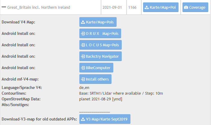
https://www.openandromaps.org/en/downloads
has a dedicated style
https://www.openandromaps.org/en/legend/elevate-mountain-hike-theme
and better coverage all over the world
I followed the instructions on OpenMaps.Eu * under construction how to install the map and how to install and activate the required render theme.
The render theme interprets how the vector data gets rendered on the phone.
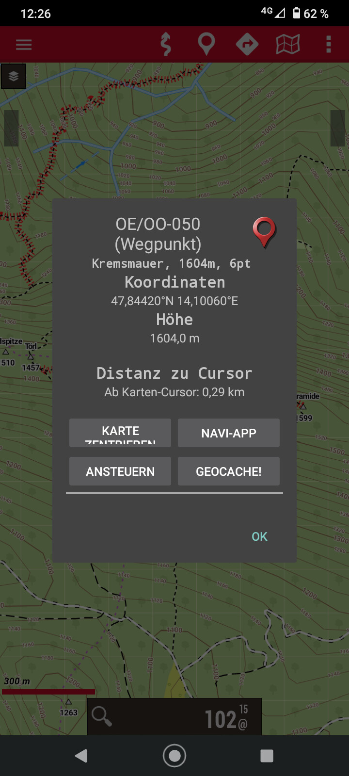
In addition I have added the OE.kml (from the summit page of sotl.as or from sotamaps.org as map overlay to that I have all OE summits show up on the map directly.
In Oruxmaps this kml needs to be saved in
/oruxmaps/overlay/ and selected from map overlays.
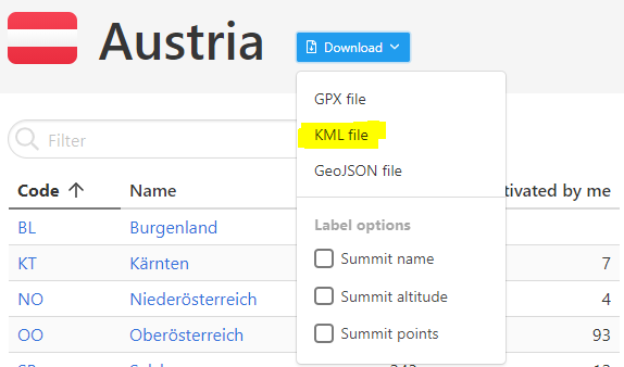
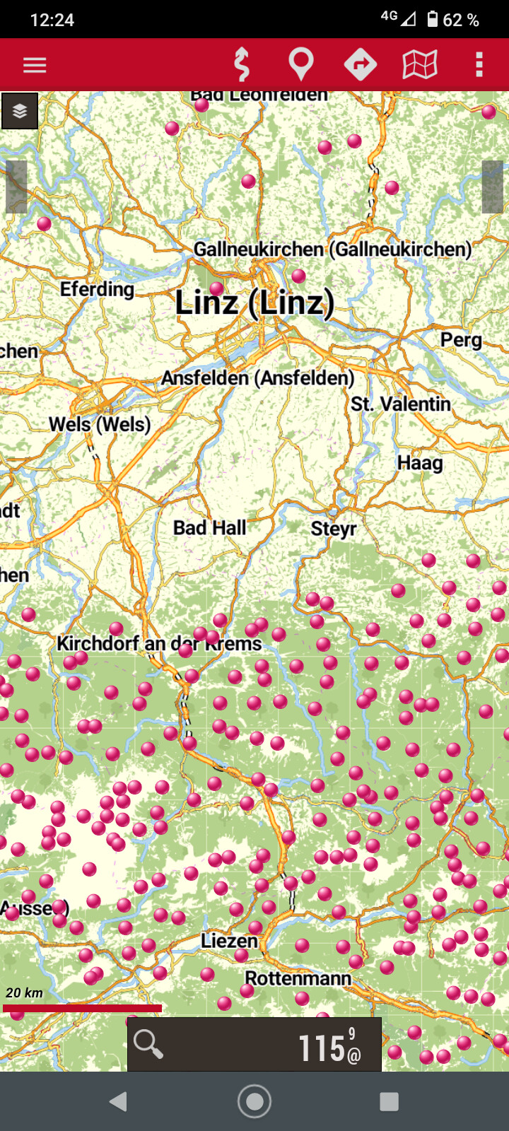
And that’s how this looks for Austria
Oruxmaps of more or less the full OE/OO area:
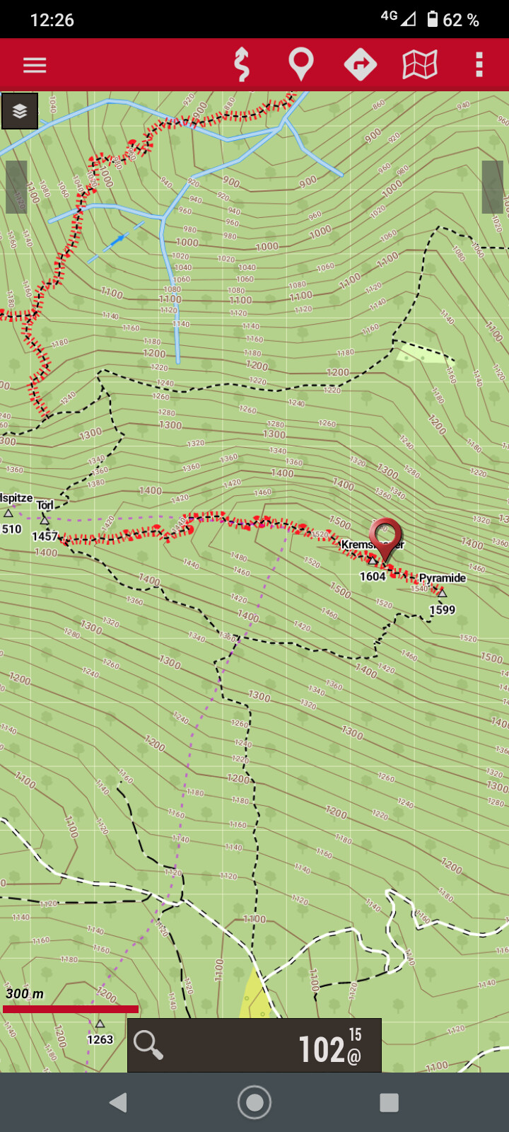
Zoom in with quite detailed elevation lines on Kremsmauer OE/OO-050
Info from the kml overlay on the SOTA summit
Big advantage is that I have full map coverage of Austria on high details with just 294 MB. And because it is not a prerendered map, features can be selected/unselected. That is for example is
- hiking path
- public transport
- elevation lines
- bike routes
- winter routes
And all of that - once installed - works in airplane mode and without any data connection.
I am of course not affiliated with any developers of those apps. Just a user of this free software.
73 Joe
7 Likes
Hi Joe,
Thanks for your information about OpenMaps.eu that I used some years ago with my Garmin GPS.
Today, I also mainly navigate using my Android smartphone alone, since it’s more convenient than a dedicated GPS. Since I also use the the smartphone for car or bicycle navigation, logging, spotting and taking photos, I can keep the weight to a minimum.
If the phone needs charging, I use a light and cheap Chinese 5V-USB converter that I connect with my LI-Ion or LifePO4 battery. And if the phone dies, I still have an older backup one with me that contains the same software, which I update from time to time. Sometimes it’s good to have an older software version installed 
Until now I used OsmAnd that is also available for iOS. It’s available as free and paid version. I use the paid version with contour lines.
When I bought it several years ago, the one-time fee was just a couple of bucks, but now it’s definitely not cheap anymore! But if you’re happy with a certain area or a few small countries, it’s still free.
The convenience is that the maps are updated within the app and of course I also use the SOTA summits as overlay. Until now, I relied on its maps in 6 different European countries and I had no issues so far with finding a way to a SOTA summit.
Otherwise, I think OruxMaps, together with an Opentopomap could be a viable alternative, but it’s some time ago I tried it and I never tested it really thoroughly.
73 Stephan
BTW: Your link to the free Oruxmaps APK returns a 403.
Looks like the page does not allow direct download. The page is a bit packed with ads so that’s why I wanted to provide a direct link. Link changed to the download page.
Thanks Stephan for shareing your experiences. As usual there are multiple options available. For me it was a nice find to share with the community.
2 Likes
They’ve not done the UK yet so I’ll have to stick with the big version. I only tend to use Orux when SOTAing outside the UK so it’s just a case of copying the files onto the SDcard that lives in the phone I use for navigating, an old Moto G(4g). For Scottish WX you need a proper GPS that’s water proof, midge proof and usable when your hands are wet, your gloves are wet, its screen is wet and your brain is wet. Not found a touchscreen phone that works in those conditions so far!
3 Likes
Totally clear Andy. I am also not suggesting to only rely on your phone. Having the dedicated GPS makes sense for such conditions.
But as a backup it definitely make sense.
Btw.
European Cycle and Hiking maps download for Android Smartphones
also has it available.
Where available including 10 m resolution elevation accuracy. Not too bad either
1 Like
I have been using GPS MAPS 3D on my iphone for a few years. It is very easy to use. It’s called 3D … but I prefer the 2D view.
The most important thing is that I can select map sections and download them as offline maps at a good scale. The marker from the gps signal always lets you know where you are.
It was a valuable help for me when I was hiking in France and Spain.
73 Armin
1 Like
I must do some upgrades Joe. I have an old version of Orux on my collection of Android devices. I know how to use it and that it works. It has never given me any surprises when out in the wilds of OK or F when using it so have been reluctant to upgrade it. I keep the .APK on the SDcard so if I do upgrade and don’t like the newer version I can be an old Luddite and revert  A bit like the WinXP refusniks!
However, time and tide wait for no man so some downloading and testing later is probably worth while. I would do it now because I could do with a break from trying to get a massive spaghetti-like amount of C++ classes with multiple inheritance, poly-morphism etc. etc. working. A daytime nightmare… it looks like someone got a copy of Stroustrup’s book and worked down the chapters saying “I’ll have one these, some of that, oh that’s funky we’ll have that.” and now I need to change it, the slightest tweak and it falls in a big pile of 1’s and 0’s on the desk 
1 Like
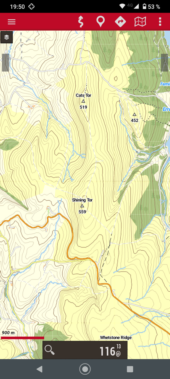
I gave it a try and here the well known Shining Tor G/SP-004 using the map from Androidmaps and the render theme from Openmaps.eu (because it has better details on elevation lines).
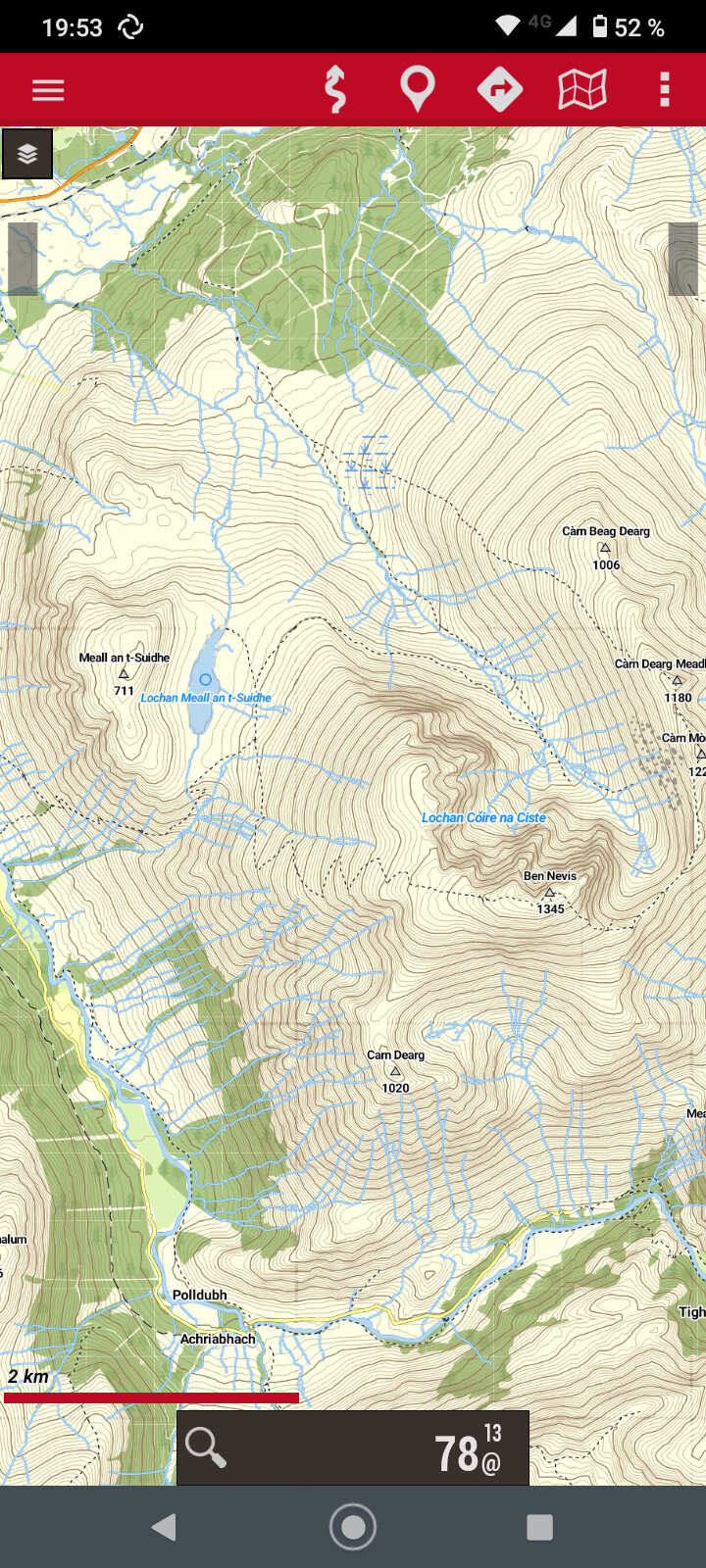
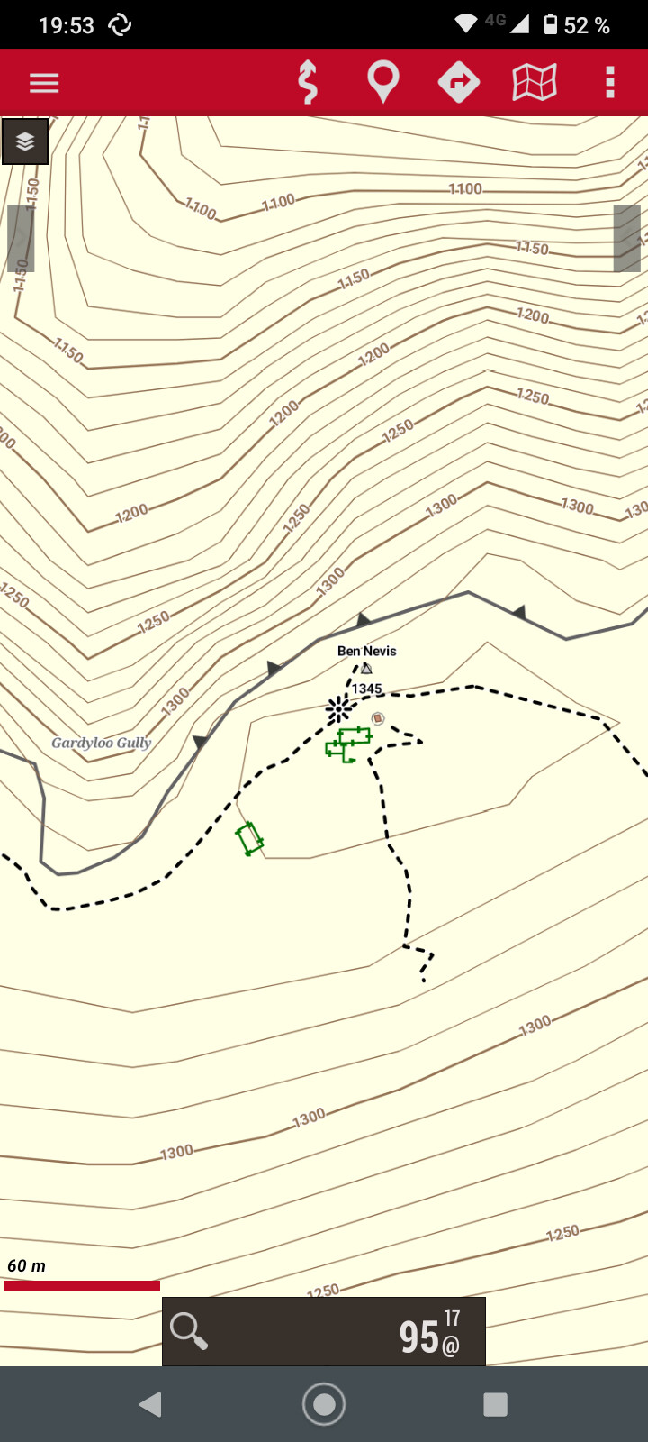
And Ben Nevis because I have been there before my SOTA times
Of course not as detailed as an Ordnance Survey maps but not too bad?
1 Like
I downloaded the latest version of the UK map in V4 format and that renders fine on my older Oruxmap install. The map is much bigger than the last UK map I had but has lots of new details including some houses being built near me, they’re not finished yet but are on the map. I also downloaded the latest render theme. I’ve got the following “Elements”, “Elevate”, “Oruxmaps V7” and about 5 or 6 Andromaps themes like Andromaps_mtb or Andromaps_hike.
Indexing into and displaying from a 1.3GB map file on my old Moto G(4g) with only a quad core 32 bit CPU and 1GB of Ram gives it a work out but it’s eminently usable still.
2 Likes