The region manager or association manager is your first contact. They need to investigate the data available and decide whether a change is necessary.
In the meantime, you activate the peak that’s identified in the sota database, that’s the golden reference.
As Peter noted, the 300 ft gap means the other peak is not in the activation zone.
It is amazing how many times this can be observed - there are many twin peaks. Maybe it is due to volcanic activity that has destroyed the original higher peak between the ones now remaining. but that’s just a wild guess.
No, just humans. The West Peak was definitely higher until the military flattened it to build a radar station on top. The mountain was raised due to geological activity of the San Andreas fault that runs nearby.
This got so complicated that I made a spreadsheet.
Note that there are two references for elevation in NA and they can vary by a few feet, National Geodetic Vertical Datum of 1929 (NGVD29) and North American Vertical Datum 1988 (NAVD88). It is OK to compare elevations using the same vertical datum, but don’t compare across them.
I also have elevations from the National Elevation Dataset. That appears to be the most recent. I downloaded LIDAR data for the area, but I have no idea what to do with a “.las” file. The best NED data is good to one meter. I’m not sure what the error is for the Mount Tamalpais ridge data.
The historical USGS topo gives elevations as of 1952, which is after the peak was bulldozed. All elevations in this spreadsheet are after that.
After all this, I believe that Lists of John might be wrong. Those elevations are from the most recent USGS map. The elevation for West Peak needs to be interpolated from the contour lines. The marker is on the fourth line above 2400 feet, one contour below 2600 feet. My guess is that someone misread the 40 foot contours as 20 foot contours and recorded 2580 (2600 - 20) instead of 2560 (2600 - 40). Easy mistake to make.
Peakbagger appears to get their elevation numbers from topo maps, but a one meter difference is almost certainly beyond the accuracy of the data without a dedicated survey.
Finally, the county highpointers site has some discussion about this. They are convinced that West Peak is higher. One report references a 2003 survey. There should be some survey data because of the nature restoration work on West Peak and because East Peak is a fire lookout.
See if you can convince the guys that do the RHB surveys to fly over and sort it out. I doubt there’ll be much appetite to change without that degree of accuracy, given the variations. Or, perhaps reach out to a local university/college survey faculty and see if they need a real-life field exercise
The W6 SOTA team (myself as AM, the RMs and others) are aware of the East/West confusion surrounding Mt Tam. Discussion continues and a resolution will be shared.
My preliminary guidance is that we need to activate at the coordinates contained in the official SOTA summit database which places our Mt Tam at the edge of the military listening/whatever area (i.e West) and not the classic Mt Tam look out tower (East).
We have worked off of List Of John data which we consider to be definitive and this has been the foundation for most all of the US associations. Current List of John data shows three peaks on a ridge (east, middle and west) and lists the west as the highest (i.e our Mt Tam).
Mt Tam has been activated many times in the last few years and published trip reports show people going to the correct SOTA Mt Tam (i.e West) and some unfortunately to East. The coordinates of the SOTA Mt Tam were not revised (i.e changed) in the recent (early 2016) revision of the ARM.
To recap, we are aware of the confusion and for an activation to both be in the spirit of SOTA and adhere to the rules the AZ is centered on Mt Tam West.
[quote=“W6PNG, post:27, topic:15611”]and some unfortunately[/quote]The possible West-or-East confusion might be worth a specific note on the summit’s page at SOTA Summits perhaps? (…but best it come from someone who’s actually been there…)
Steve,
Cool antenna! You should give it a spin on the 2 meter Bozo net Sunday and Wednesday 730 PT 144.24.
I’ll alert the local Lake/Mendocino weak signal folks to point your way 7/29. Share ETA when closer.
Mel KK6TMN
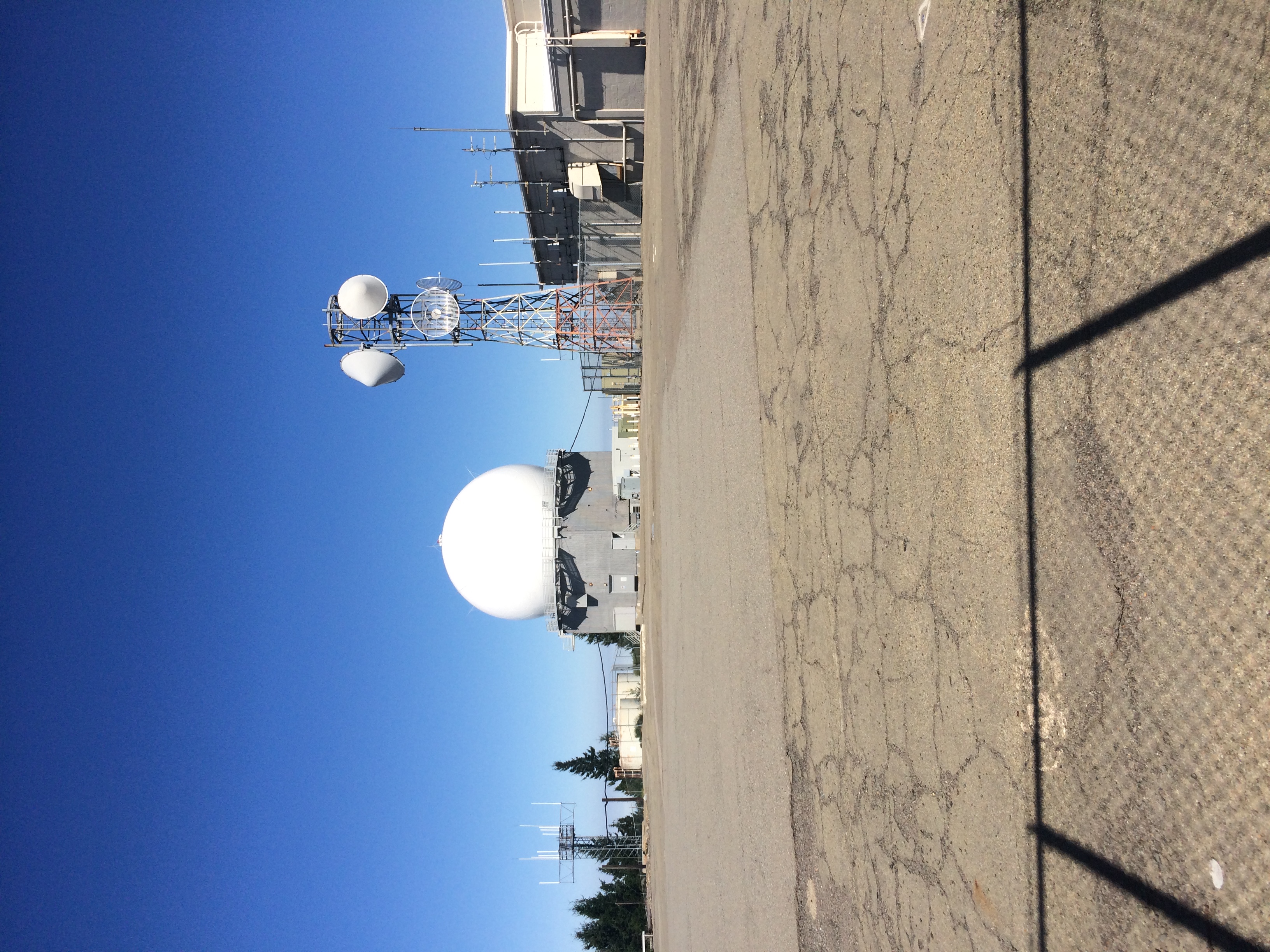
A view of the summit from the perimeter fence. The exact point of the summit is adjacent to the tower holding the microwave antennas. The fence is about 16’ high with very clear warnings that this is an FAA Radar installation and "do not even think about crossing the fence. This view is from the east side of the installation looking west toward the radar.
I also hunted down the data sheets for the survey markers (“benchmarks”) on both peaks. Those are less useful than I hoped because they are “approximate vertical” marks. One near the West Peak summit is at 785.2 m and one at the fire tower on the East Peak is at 785 m (both NAVD88). I’m guessing that 20 cm is a bit beyond the accuracy.
The survey marks have been “recovered” recently, but that just means they can still be located. It does not mean they were resurveyed.
The summit listed in the ARM is the one that counts, obviously.
The elevation evidence is not conclusive.
I’m curious whether the LIDAR data for East Peak is reading the (rather substantial) fire lookout as the summit.
Clearly, we all need to climb both summits more often. With GPS units.
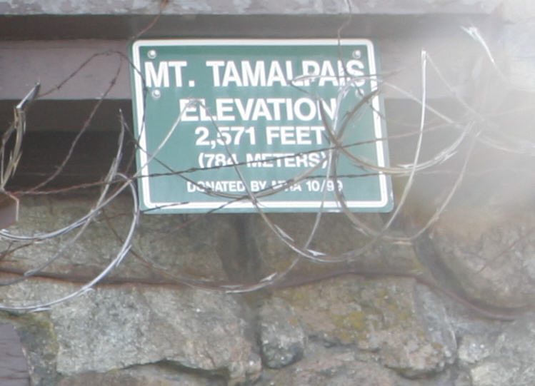
For a relief from all the numbers, here is a group photo at East Peak on a Boy Scout hike in 2008. We are on the steps of the fire lookout, which probably covers the highest rocks on the summit. If you zoom in, you can see the sign that says “Mt. Tamalpais, Elevation 2571 feet”. I’m the one with the beard.
Update: A family commitment has come up which may force me to reschedule. At this point, however, I am leaving my alert posted in the hope that I will still be able to go through with it this Saturday.
I will post further updates here if I am forced to change my plans.


 I guess we’ll just have to be patient and see what is decided.