G1ZAR
16 October 2023 07:20
1
Is it possible to add some more microwave information in the database?
Thank you.
2 Likes
G4VFL
16 October 2023 10:33
2
Hi Stuart
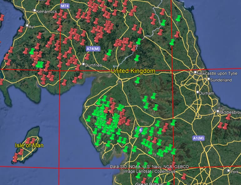
The easiest way is to download all the QSOs from the database. There are not too many microwave activators then process them yourself to answer any queries you have. I use SQL for the processing this lets me join the QSO file with the Summit file which is quite handy. From that I can derive a .kml file to plot results onto Google Earth.
Thus for the 23cm Band I can produce the following activation table.
SummitCode
SummitName
Longitude
Latitude
QSOs
G/LD-001
Scafell Pike
-3.21168
54.45426
3
G/LD-003
Helvellyn
-3.01751
54.527
2
G/LD-004
Skiddaw
-3.14776
54.65139
12
G/LD-005
Great Gable
-3.2193
54.48208
2
G/LD-006
Pillar
-3.28113
54.49748
1
G/LD-007
Fairfield
-2.99165
54.49705
2
G/LD-009
Grasmoor
-3.27791
54.57164
1
G/LD-010
St Sunday Crag
-2.97584
54.51194
2
G/LD-012
High Stile
-3.2837
54.52184
2
G/LD-013
The Old Man of Coniston
-3.12145
54.37066
2
G/LD-014
Kirk Fell
-3.24412
54.48332
1
G/LD-015
Grisedale Pike
-3.24207
54.59175
2
G/LD-020
Dale Head
-3.20228
54.52724
1
G/LD-021
Robinson
-3.23508
54.54081
2
G/LD-022
Seat Sandal
-3.01403
54.49486
2
G/LD-024
Pike of Blisco
-3.12493
54.42811
2
G/LD-025
Seatallan
-3.32827
54.46407
3
G/LD-028
Harter Fell (Eskdale)
-3.20454
54.3869
9
G/LD-029
Illgill Head
-3.28263
54.43293
1
G/LD-030
Black Combe
-3.32857
54.25776
45
G/LD-031
Blake Fell
-3.3772
54.56457
7
G/LD-032
Whitfell
-3.2949
54.32547
9
G/LD-033
Lord’s Seat
-3.23398
54.62782
1
G/LD-034
Hard Knott
-3.18503
54.41103
1
G/LD-035
Great Mell Fell
-2.93564
54.61985
2
G/LD-036
Mellbreak
-3.31826
54.55558
1
G/LD-037
Little Mell Fell
-2.89447
54.60802
2
G/LD-038
Grayrigg Forest
-2.61958
54.39211
5
G/LD-040
Lingmoor Fell
-3.07641
54.43207
11
G/LD-041
Binsey
-3.20419
54.7088
1
G/LD-042
Low Fell
-3.33661
54.59136
1
G/LD-045
Dent
-3.48165
54.50233
35
G/LD-046
Lambrigg Fell
-2.63702
54.34149
2
G/LD-047
Loughrigg Fell
-3.00836
54.43745
1
G/LD-048
Top o’Selside
-3.06385
54.31808
2
G/LD-049
Kirkby Moor
-3.13726
54.24558
3
G/LD-050
Gummer’s How
-2.93791
54.28836
4
G/LD-051
Holme Fell
-3.05653
54.3963
11
G/LD-052
Hutton Roof Crags
-2.68044
54.19141
2
G/LD-053
Claife Heights
-2.95265
54.36786
2
G/LD-054
Watch Hill
-3.30415
54.67445
1
G/LD-056
Whitbarrow - Lord’s Seat
-2.85883
54.276
4
G/LD-058
Arnside Knott
-2.83503
54.19019
2
G/LD-059
Muncaster Fell
-3.36314
54.37582
4
G/NP-001
Cross Fell
-2.48696
54.70309
2
G/NP-002
Mickle Fell
-2.30188
54.6157
2
G/NP-003
Burnhope Seat
-2.33626
54.73258
1
G/NP-004
Whernside
-2.40339
54.22765
2
G/NP-005
Ingleborough
-2.39782
54.16643
1
G/NP-006
Great Shunner Fell
-2.23452
54.37089
1
G/NP-007
Wild Boar Fell
-2.37411
54.3841
2
G/NP-008
Great Whernside
-1.99836
54.16105
1
G/NP-009
Buckden Pike
-2.0616
54.20486
3
G/NP-010
Pen-y-ghent
-2.24874
54.15601
2
G/NP-011
Great Coum
-2.46056
54.24706
2
G/NP-012
Baugh Fell - Tarn Rigg Hill
-2.40002
54.31973
3
G/NP-013
The Calf
-2.51335
54.36784
2
G/NP-016
Dodd Fell Hill
-2.24557
54.25668
1
G/NP-017
Fountains Fell
-2.20941
54.13993
2
G/NP-018
Nine Standards Rigg
-2.27036
54.4499
1
G/NP-019
Yarlside
-2.48544
54.38132
2
G/NP-020
Cold Fell
-2.61625
54.89391
1
G/NP-022
Calf Top
-2.51661
54.26518
3
G/NP-024
Hoove
-1.99872
54.45761
1
G/NP-027
Dufton Pike
-2.46647
54.6339
2
G/NP-031
Birks Fell
-2.12594
54.18296
1
G/SB-001
The Cheviot
-2.14544
55.47847
3
G/SB-004
Peel Fell
-2.5906
55.2902
1
G/SB-005
Sighty Crag
-2.62663
55.12109
2
G/SB-007
Tosson Hill
-1.99395
55.27836
2
G/SB-009
Ros Castle
-1.87319
55.52159
3
G/SP-001
Kinder Scout
-1.87391
53.38481
4
G/SP-002
Black Hill
-1.88532
53.538
3
G/SP-003
Ward’s Stone
-2.62434
54.02302
3
G/SP-004
Shining Tor
-2.00932
53.26068
2
G/SP-005
Pendle Hill
-2.29857
53.86856
1
G/SP-006
White Hill
-2.49928
54.02409
1
G/SP-007
Fair Snape Fell
-2.61463
53.92018
2
G/SP-008
Boulsworth Hill - Lad Law
-2.10825
53.81692
1
G/SP-009
Hail Storm Hill
-2.25126
53.67034
1
G/SP-010
Winter Hill
-2.51588
53.62984
2
G/SP-011
Freeholds Top
-2.14384
53.69328
2
G/SP-012
Easington Fell
-2.41231
53.93359
1
G/SP-013
Gun
-2.04622
53.15078
3
G/SP-015
The Cloud
-2.1447
53.17037
3
G/SP-017
Billinge Hill
-2.71678
53.50741
2
G/WB-002
Brown Clee Hill
-2.59958
52.47673
3
G/WB-003
Stiperstones
-2.93486
52.58192
3
G/WB-004
Titterstone Clee Hill
-2.60196
52.39805
2
G/WB-005
Long Mynd - Pole Bank
-2.86378
52.54467
3
G/WB-006
Caer Caradoc Hill
-2.77212
52.55384
5
G/WB-009
Worcestershire Beacon
-2.33895
52.10494
1
G/WB-011
Bradnor Hill
-3.05192
52.21949
2
G/WB-012
High Vinnalls
-2.76782
52.34722
1
G/WB-021
Ruardean Hill
-2.53141
51.84961
1
G/WB-024
Aconbury Hill
-2.7211
51.9932
1
GM/SS-042
Shalloch on Minnoch
-4.50248
55.18365
2
GM/SS-092
Millfore
-4.38383
55.05024
1
GM/SS-178
Craignell
-4.33376
55.04911
1
GM/SS-196
Calkin Rig
-3.11815
55.17778
1
And a snip of map
73 de
Andrew G4VFL
2 Likes