No. That figure is based on it being at Lat/Long Zero (in the Gulf of Guinea), when it was sending null positions without sat-lock. It was actually over the Irish Sea today, flying at an altitude of 11.5km, from where its horizon would be under 400km.
If it’s sounds too good to be true, it usually is. Seems like a case of garbage in, garbage out.
…a problem I’m having with the tracker into which I loaded firmware via @CA2RXU 's CA2RXU LoRa Tracker Firmware Flasher earlier. It’s been sitting with a view of the sky for three hours and still hasn’t figured out where it is. I’m beginning to suspect I loaded up the wrong version…
most of the times, when flashing the board for the first time or updating the firmware the gps needs to download the almanac (list of available gps) and this takes time.
so I recommend to leave it outside and return to it after a few hours… after this process, each time it reboots , the time to get gps fix will be just lower than a min with clear sky
1 Like
More likely that the ceramic antenna unit is faulty - do you have another you can swap in from a known good unit? Replacement units only cost a few pounds and then you could get one with a larger patch antenna for improved performance.
But take care unplugging them from the tiny U.FL connector - I once managed to pull the socket off the board on my T-Beam (then managed to fit a new one, fortunately).
1 Like
LB5JJ with the T Deck Plus

1 Like
It was working well enough with the previous version of the code.
In the past I’d have expected an almanac download not to take more than an hour or so. Three hours seemed excessive. I’ll charge it up again, try and find somewhere dry where it can see the sky, and hope the battery holds out long enough (but, looking at the weather forecast, that might not be soon.
I had a problem trying to get the latest Heltec version to work (2025 date).
Reverted to a late 2024 version and fired up perfectly
The one I tried was “Heltec Wireless Tracker V2.1.4 (11 January 2025)”. I’ll give V2.1.1 (21 December 2024) a go and see whether it gets a fix any quicker…
Hi John,
If you can fix the weather in the Lakes, we’ll happily visit and activate more regularly (carrying our LoRa tracker).
On average though, every time we’ve visited the area in the last few years, we’ve lost at least 50% of our holiday visit days to bad weather (bad enough that SOTA is not feasible I mean). Compared to visiting Spain, France, Andorra etc, where we have maybe lost 5% of days, and had to walk in a valley instead of in the mountains.
Further, it’s generally more expensive for us to stay in the Lakes for two weeks, than it is to fly to Barcelona, rent a car and then stay in an apartment on the Spanish border.
Not that I want to put people off visiting the Lakes of course, but if you are limited to ~25 days of A/L per year from work, those days really need to be utilised effectively.
73, Simon.
nothing has changed in the way it processed the GPS from more than 1 year. So if it gets faster fix is only because of the flashing process one time
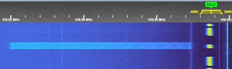
A screenshot taken from the GB0SNB Kelvedon Hatch WebSDR in Essex, I was looking for LoRa signals on 439.9125 MHz and this appeared (ignore the fact the receiver is tuned for a different frequency), no wonder LoRA can’t be used on 2M
I installed V2.1.1 (21 December 2024). The weather’s not good, so I’m relying on the sky it can see from a windowsill, but it got a fix fairly quickly. Well under an hour, anyway.
I’ve now re-installed V2.1.4 (11 January 2025) and put it in the same place to see how quickly it gets a fix. Satellite geometry will, of course, have changed a bit, so it’s not an exactly repeatable test.
Edit: …and it got a fix within 30 minutes. I’m guessing yesterday’s “over three hours and still no fix” issue must’ve been something like a bad mix of wet weather and satellite geometry…
1 Like
I had some spare time this morning, so I went out to give the tracker some further testing, the first place I checked was Pistern Hill (186.0 m (610 ft), which is near Ashby-de-la-Zouch, Leicestershire, this is the highest point of the Ashby Woulds, which runs along the A511 from Swannington Roundabout, Coalville to Swadlincote (Newhall), Derbyshire. From there, I drove to Ipstone Edge (386m / 1266ft) on the Staffordshire Moorlands, which is just a bit higher than Gun Moor by a metre.
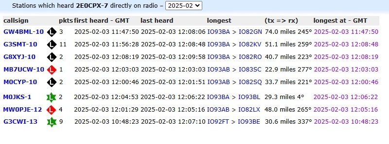
The best of the day was GW4BML -10 at 74 miles, which is a record for me using LoRa, however, this hasn’t beaten AX25 APRS on 2M at Beacon Hill, Leicestershire to MB7UC, Barkway, Hertfordshire.
There was a comment on the mobile APRS thread about " we should be concentrating on putting LoRa digipeaters in SOTA regions" I think this is a bit blinkered for several reasons, aside from the fact that only East Anglia isn’t a SOTA region, I can’t see the point of sticking LoRa digipeaters on the sides of hills and mountains if they are SOTA summits because the likelihood is they won’t hear any LoRa signals from the summit as they will be shielded. when you would be better placing them at more of a distance, for example, if you wanted to cover the Three Peaks of Yorkshire (G/NP-004, G/NP-010, G/NP-005 ) then an ideal position would be somewhere like Caton Moor a few miles west of Lancaster which has views of all three, this isn’t a suggestion just an example of how summits can get covered.
The post was mine but your quote in parenthesis isn’t mine. Paul, as Richard @G4TGJ pointed out [on the other thread] you misrepresented what I actually said, which was about placing LoRa APRS iGates in “summit-rich” SOTA regions. The deployment of carefully-placed digipeaters is for mountainous regions like G/LD where adequate coverage cannot be achieved from QTH-based iGates alone.
Here’s a link to my original post for anyone who wants to confirm what I said …
1 Like
Apologies, I had two pages open and it seemed to be posted to the wrong person
Now I’m more or less over a recent cold and temperatures are creeping up I’ve (re)started gentle SOTA activations (e.g. Gummers How G/LD-050 last week) and WOTA’s too (the latter last Thursday where my daft 4yo golden retriever broke his toe and is now confined to barracks and wearing a splint for the next 4-6 weeks) I’m getting on-the-ground LoRa APRS coverage info for those walk-ins (at least from my favourite starting points).
Walking the other (more sensible) dog on my nearest and dearest local summits (Arnside Knott G/LD-058 yesterday and Hutton Roof Crags G/LD-052 today) with LoRa tracker, the post-walk apr.fi map analysis [looking at where each tracker packet was routed] shows the advantage of having a number of iGates at different locations in the area as the walker moves between different line-of-sight (or near LoS) RF paths or even ones reflected off the hills.
We are already well served by iGates in the south of the county. For example, today’s G/LD-052 walk involved 3 iGates (G8CPZ-10, M0RBE-10, M5TUE-10) in south Cumbria and one digipeater (MB7ULU-2) in north Lancashire (Lancaster University).
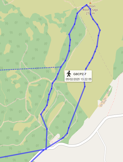
LoRa APRS coverage for G/LD-052 walk-in

Coverage is poor in north Cumbria at least from the M6 around Carlisle and probably to the west. How well it is on those northern summits is still an unknown. Tracker-based activations needed.
2 Likes
Nominate the LoRa APRS Tracker for the ARS Award!
The LoRa APRS Tracker, developed by Ricardo Guzman (CA2RXU), has significantly impacted the amateur radio community—especially for those involved in SOTA, portable operations, and off-grid adventures. This open-source project has revolutionized APRS communication by enabling low-power, long-range position reporting, messaging, and telemetry.
With its affordability, flexibility, and ease of use, the tracker has made APRS more accessible to operators in remote areas, offering an alternative to traditional RF and internet-based solutions. Whether you’re using it for SOTA activations, emergency communication, or experimenting with APRS over LoRa, this device has proven to be a game-changer.
Now, we have a chance to recognize this incredible project by nominating it for the ARS Award! ![]()
![]() Submit your nomination here: Amateur Radio Software Award - Award Nominations
Submit your nomination here: Amateur Radio Software Award - Award Nominations
Let’s support Ricardo’s work and help bring more attention to this innovative technology!
4 Likes
Nice idea Piju @9M2PJU , I have just submitted my nomination for Ricardo ![]() 73
73 ![]()
1 Like