Thanks Andy. I understand the difficulty now. Thanks for the explanation. Another chance for first activation!
Wish it had come out a few months back… I was in northern Italy and would have had loads to go at!
Thanks as always for all the work on this by so many folk, especially the massive work by those picking the new summits out and getting them into order for loading up in the database.
We did have a similar situation to this in the UK where one of the summits Black Mountain has the England/Wales border running on it. Initially the true summit was on the English side of the border, so the SOTA reference was G/WB-001. However the true summit was actually found on the Welsh side of the border, so Black Mountain was valid as G/WB-001 until New Years Eve 2007 and then valid as GW/SW-041 from New Years Day 2008. When the SOTA reference changed, Black Mountain did became of unique summit to those who activated on the old reference, quite a lot of people have 2 uniques for Black Mountain including myself who have activated it as both G/WB-001 and GW/SW-041.
The situation you are describing Gerald in Italy where summits have changed region in the recent update, I see as no different to the Black Mountain situation we had 10 years ago.
Yes that’s fine. Just wanted to get it straight in my own head. With explanations from Andy and you it is clear now. I suppose the only difference is I am guessing in volume. Not the odd one or two, but dozens.
Hi Gerald,
Also I/LO-307 Resegone has changed ref and name in I/LO-177 Serrada.
This evening I charged my log using the old ref., it would be right to unify.
The most famous name is Resegone but in some old maps it’s possible find the old name from spanish domination Serrada.
Be careful doing this. The old summit reference has a Valid To date (of September 30) and the new summit ID is only valid from October 1. This means if you activate the old reference before Sep 30, but log it as the new summit, you’ll find you’ll lose points. The two references do not coexist for points purposes.
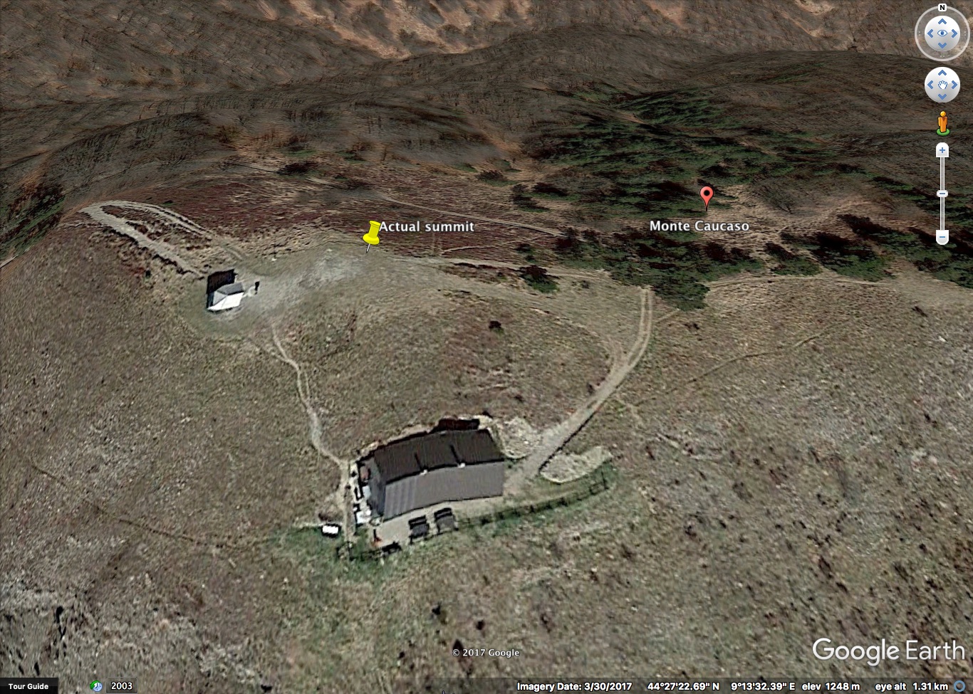
By these informations, I wonder why the summit Caucaso, in LG region is missing now. It was the first activated italian summits when sota started in Italy. We lost informations about it but not the memory.
I said: the highest summit of Caucaso is over 1200 mts above the sea. It has secondary peaks (mount Larnaia and mount Rocca Cavallina, not higher), and these peaks have saddles and those saddles exlude them by the rules of prominence (the key col is under them). The error is exluding also the main summit because there are saddles among it and the secondary peaks.
For the same reason as for any other summit not included in the SOTA scheme: it does not have the required prominence.
If you feel this is an error, please provide the exact coordinates and the exact elevation of the summit and its key col, together with a copy of the source of your information.
If the difference between the elevations is indeed more than 150 meters, the error will be corrected.
If all people “wondering why a summit is not included” would only spend some time to join the effort of identifying the summits that have the required prominence, things would be a lot faster…
OK OK
I worked hard all morning to find the real answer to “my problem” (apart from the missing IT-Association support)
The answer is shown here:
A stupid shallow col, between 50 and 100mts long, chains the important peak of Caucaso to higher (not so higher, LOL) but less important peaks, over 8kms far to the north.
With P140 there wouldn’t be any problems.
Apart from this P140, this little tongue of terrain, the mountain falls down to bottom of the valleys in every direction: common situation for peaks in front of the sea.
The rules say:
“associations wishing to use a P less than 150mts will need to offer justification and be able to demonstrate how P<150 will add to the viability of a prospective association”
I think that P150 is a fleeting rule for italian Appennino mountains: summits are often chained on 1 or 2 sides and it isn’t good to sacrifice a high and important summit.
I’d say: an italian association could change the P150 rule to a P100, but giving no more than 2 summits every 10 or 20 squared kms (?).
This would be fair and wide enough to avoid situation like this summit, new one next to Caucaso, which has no landscape, hystorical, and neither hiking relevance:
Sorry guys, I understand your desire to find a rule “to conquer all the planet”, but math means nothing compared to a beautiful landscape, to history and culture.
I am glad you can see by yourself that this beautiful summit does not meet the required prominence.
Everyone would like to bend the rule to get the summits he likes included. Hence the simple and unique rule of P150.
You might have missed the fact that the major review just performed ADDS nearly 3.500 valid SOTA summits in Italy, while removing the ones that did not meet P150. It also corrected an awful lot of mistakes in the coordinates from the previous lists.
Nothing prevents you from enjoying and/or activating any summit you wish in Italy, but only the ones with P150 are part of SOTA. You might also want to consider other awards schemes like WWFF, as many summits are also in natural zones: maybe you can activate some of the places you love but that do not have a prominence of 150 meters, and still participate to an important award scheme.
Now, as you show an interest and abilities in the field, may I suggest that you propose your help to the many Association Managers to improve the summits data in their association ? The more eyeballs focused on the maps, the better the data will be.
This rule needs its wording improved. A careful reading of the rest of the rules will reveal that SOTA only permits one deviation from P150, and that is P100. P100 is only permitted where the summit density of the proposed Association is less than one P150 summit per 2,000 km^2 (GR 3.5.6. pp10 and 11.) This deviation from the principle of P150 was brought in so that entities with a severe shortage of summits could still participate in SOTA. Italy cannot be described as having a severe shortage of summits!
The fact is that landscape, history, hikability (if there is such a word) or sentiment of any sort is not relevant to SOTA. SOTA stands by prominence, and prominence alone. We all have summits that we are fond of and wish that they were included in SOTA - I know that I have! - but with thousands of participants in SOTA, if they all demanded special exemptions we would never get anything done!
But what would you say if I show you a local map with clear contours, taken by the official website of this mountain? http://www.anellodelcaucaso.com/wp-content/uploads/2016/11/carta-anello-caucaso-cicloturismo-MBT.pdf
If we accurate follow the countours, we see that the shallow col between Caucaso and Larnaia is really thin, maybe 10 to 20mts wide, and its real height asl is 1085 mts and not those 1108 of Passo del Gabba, which is located to south.
With a col of 1085 mts, Caucaso is still in sota (1085+150 = 1235 < 1245).
So I had a short conversation with a local Wikimedia manager who works everyday with regional cartographers and I asked him where I could find better maps without going mad. He told me that the easiest way is trying with Google, because all other sources are “businesses” of the big national agencies.
I opened Google Earth and navigated to the faulty place. I traced a path along the saddle (I know that place quite well since I trip to this mountain at least one time every year) and then opened up the elevation profile:
I consider some error, but the heighest point is 1089 mts asl. (1089+150 = 1239 < 1245).
By these two maps It seems like I’ve found a mistake and Caucaso is still sota I/LG337.
(The 3d model I used to find the saddle yesterday is a lowpoly and because of this it cannot be reliable for an accurate evaluation but it was surely useful to identify the critical place, I mean the real saddle).
I would say that you are conducting your argument in entirely the wrong place. Instead of putting your evidence on this reflector, where it may or may not be seen by members of the summit team, you should send it directly to the team for consideration. The means of doing this are on the website, Summits on the Air and if your findings are confirmed then the summit will be restored to SOTA.
I would like to report my reserch to the team, but: The resource you are looking for has been removed, had its name changed, or is temporarily unavailable.
What’s wrong?
Hi Stefano, it’s worth mentioning that according to Google Earth the Mt. Caucaso peak is at 1248 as you can see in the following image
Now, if we agree to rely on GE altitude data, we should consider 1248mt -150m = 1098m the limit for being a valid summit.
It would be beneficial to know which data source SOTA summit’s team uses for establish the summits’ validity, so that everyone willing to spend some time on a map can contribute checking the summits.


")