G4YSS: Failed Activation of G/SP-001, Kinder Scout on 12-04-25
Iss-2 (+OS Map) (please report errors)
Achilles Heel:
Metaphor for a person’s weakness or vulnerable point, typically a weakness that could lead to their downfall. (Kinder Downfall?)
All times BST (UTC+1)
Accompanied by Hazel & her Saluki/ Greyhound Lurcher Finn
EQUIPMENT (None Used):
Yaesu FT1500M 2m-FM/ 50W monoband mobile transceiver (1.25kg inc mic)
One 5Ah HRB Li-Po Battery
UV-5R 2m/ 70cm, 5W, VHF-UHF handheld transceiver
Half-wave vertical J-Pole for 2m with short 3-section mast
Reserves: Two UV-3R 2W dual band Handheld transceivers for intercommunications
Pack weight: Approx 9kg (20 lbs) including 1.5 ltr fluids & thermoball jacket
INTRODUCTION:
An attempt on the 1,345 metre Queimadas (CT3/MI-007) on Madeira in 2015, when I was defeated by what might best be termed 'dense jungle,’ was my first SOTA failure. Sad to say Kinder Scout has become my second. These are not the type of SOTA activity reports (or more accurately inactivity reports) I like to write but we must take the bad with the good.
This was part of a long weekend visit to family who have recently moved from Scarborough to Chesterfield. Our base was the Premier Inn North at Tapton Lock. The sortie to SP1 was originally scheduled for Friday the 11th but was moved to Saturday due to a clash with a cinema visit for my Grandson.
A favourable MWIS forecast for the Peak District National Park spoke of sunshine until late afternoon with summit temperatures from 10 to 12C and wind speeds in the range 15 to 25mph. It was about as ideal as one could wish for but the long period of settled weather was coming to an end.
Extra preparation was required for this expedition as unusually I had a guest and a dog. The dog Finn has recent experience of hill walking whilst that of the guest is impressive but historic. Some of the prep was finding a spare rucksack, Goretex and insulated jacket, VHF radio, map, compass, a second GPS with routes uploaded and a dog lunch including a can of sardines etc. Hazel supplied the remainder herself. Much of this we knew would not be needed but as usual we prepare for all eventualities. Not quite all – read on.
In the 1970’s and 80’s my visits to this area were concerned solely with finding WW2 aircraft wrecks, of which there are many but with the advent of SOTA in 2002, the focus changed. Half the fun in those days was the nav, using just the basics of the time. Then six or eight of us would ‘comb’ the ‘given position’ to locate the target. Once found, triangulation was undertaken to properly fix its position. Old skills but if you walk the hills, they may still be needed.
My log shows just one previous activation of Kinder Scout; a joint HF/VHF one with Phil G4OBK in 2006. Again the focus was on nav but this time it was GPS familiarization, my first use of that being a Garmin GPS38 in 1998 when it was still relatively poor and only good for 150m accuracy. Parking near Upper Booth, Phil and I had a memorable day, locating a handful of aircraft wrecks along the way.
A sub-aim of this activation was to try out an FT1500M mobile transceiver, recently obtained from ebay. Having heard of this rig’s weaknesses, I made a control knob protector from epoxy PBC board following bench checks which indicated that I hadn’t been ‘done.’ This 50W rig and J-Pole combi should have been capable of logging plenty of QSO’s from SP1, especially when you consider the myriad of population centres it overlooks to east, west and south, so I was quite looking forward to it. Also I discovered late from a post by Fraser MM0EFI that we’d be arriving at the summit just before the start of a UK-wide ‘145 Alive’ event. The perfect day to be carrying VHFM. It was not to be.
ROUTE via Fair Brook from A57 Snake Pass:
We were lucky enough to find parking in a rough 2-car pull-off at SK 1149 9026. (Parking on the famous A57’s narrow margins is next to impossible so if one is occupied, find an alternative pull-off up or down the road). Hazel commented that she had no phone coverage when we parked. I didn’t check mine.
Cross the road with great care and walk 50m NW to a gate which takes you off the A57 at SK 1146 9030; the Fairbrook walk’s start point. Go down the path to take the footbridge over the river Ashop at SK 1144 9017 (298m ASL) and Pass a wall corner at SK 1144 9010. Look for the National Trust sign ‘High Peak Estate Fairbrook’ on flat ground and head up the valley from there. Walk generally west beside Fair Brook via SK 1100 8991; SK 1045 8978; SK 1000 8948 to a hairpin right at SK 0933 8910, 600m ASL. This is more or less the ‘lip’ of the plateau but we never got that far.
Activation Zone:
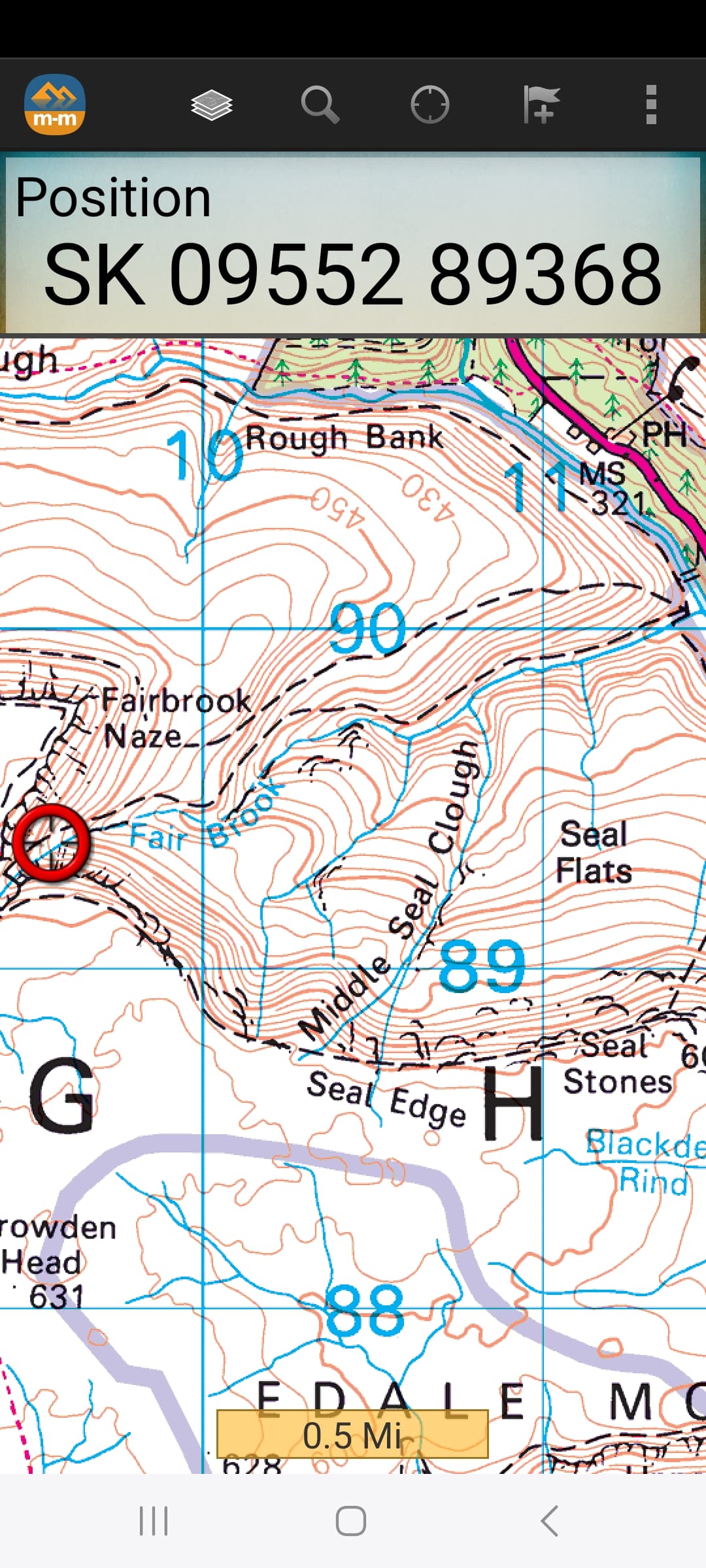
The SP1 AZ can be hard to nail down. Basically it’s a case of getting above 611m then tracing continuity on the map to the 636m top. From the plateau lip, where is marked a waterfall, we planned to take the path north towards Fairbrook Naze and activate the summit from the 619m spot height at SK 0953 8967. Either that or carry on via SK 0966 8979 to walk west to the 625m spot height at SK 0922 8980. Both these places are, as far as I can ascertain, within the allowed minus 25m activation zone (as is the 624m northern trig). A third option was to go east along the path to where it rises above the 610m contour at SK 0994 8902 then walk south until, the minimum height of 611m is attained. No prior decision was made. We could decide the lie of the land once we’d climbed to the lip.
EXECUTION:
After a 50 minute drive from Chesterfield the walk started at 10:10 in warm sunshine and a light cooling breeze. It was a joy to be out in hilly country again, in great weather and with such fine views, so what could possibly go wrong? Despite the two GPS’s, the route was well defined with no navigational difficulties. It was simply a matter of following the stream up the hill then turning right or alternatively left at the top of the valley.
Hazel, the dog and I completed a practice walk in the Chesterfield area on the previous day but my new walking shoes had caused me chaffing agony and Hazel had been worried that it would affect the Kinder Scout walk. I had no such concerns, knowing that once I stepped into my Scarpa Rangers, I’d be OK for the top. Or so I thought.
I felt fighting-fit and raring to go. Though she’d prepared well, the only other issues to be aware of were Hazel’s long-running back and joint problems but it quickly became evident that she was going as well as could be expected, so long as we paused at intervals. Certainly I was energised just by the knowledge of being back doing SOTA again and heading up a 2,000 footer. I never fail to appreciate such a situation and today I had the other two to enjoy it with. When the gradient started to increase, I let Hazel lead, telling her to take it slowly and I would follow and control the dog.
The path is rough and slightly undulating in places. Evidenced by the many beaten trails I’ve been on over the years, losing height then having to climb back up again is not appreciated by walkers but there wasn’t too much of that here. Most paths exhibit a form of intelligence or is it just laziness. There were two main steep sections with ‘steppy bits’ several minor ones and a few muddy bits to negotiate. Unfortunately Hazel sank into one of these to just over her boot tops. That caused a wet sock and a jarred a knee which didn’t help but we were OK to carry on so long as we took it steady.
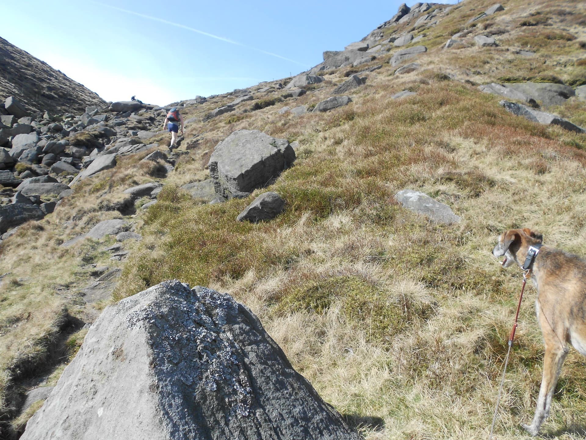
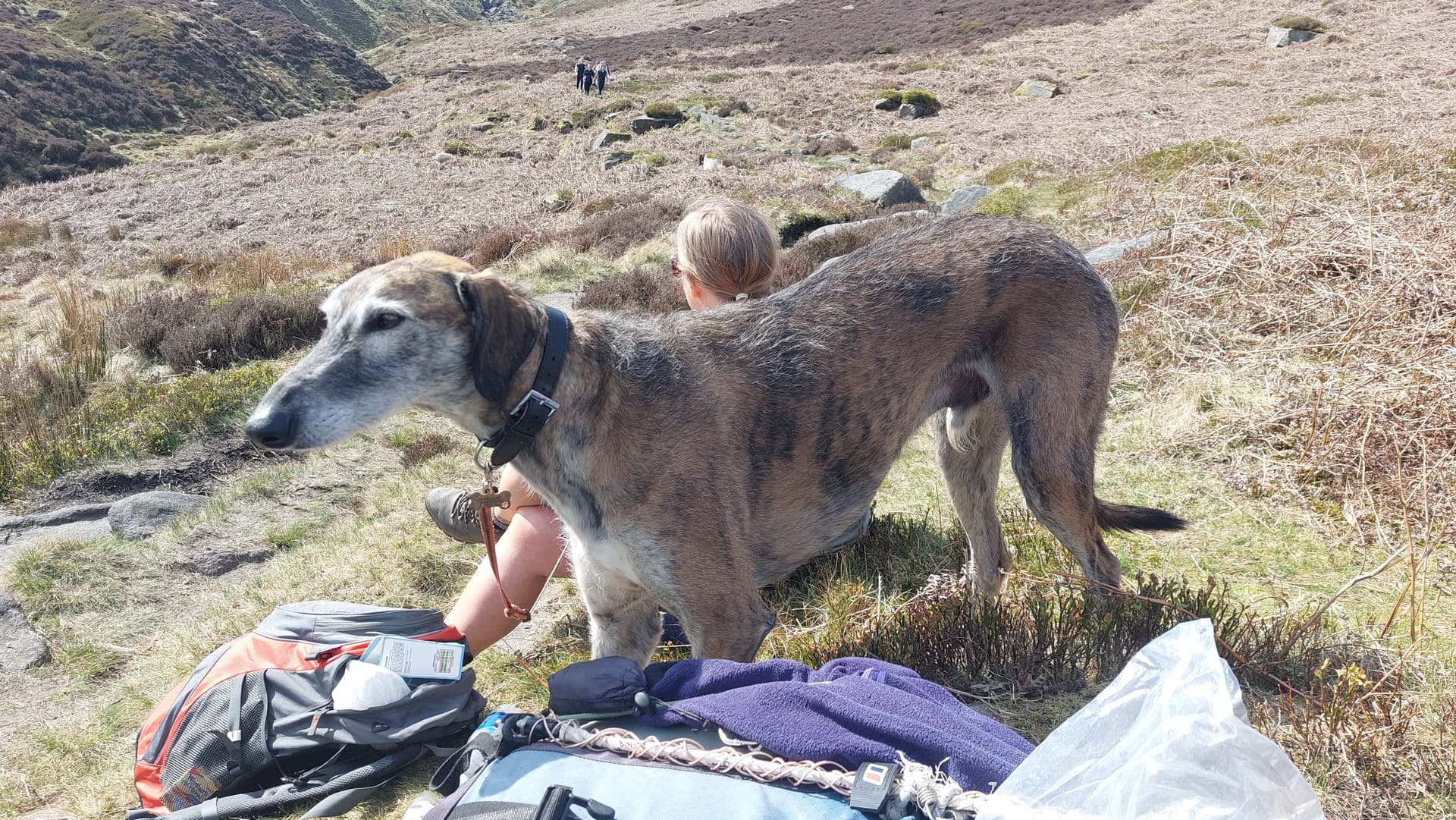
As for Finn; he was enjoying paddles and drinks at the stream. It’s not an unhappy Lurcher that rolls in the grass with his lanky legs in the air. The fact that there were sheep around and he was attached to me with a 5 metre lead for the day, didn’t seem to bother him.
‘Crack!’
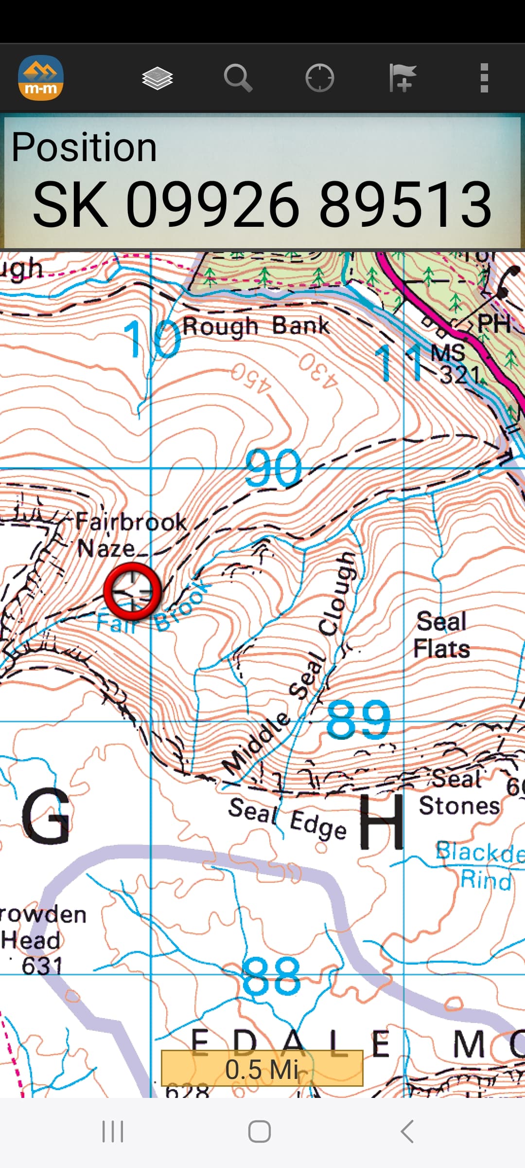
The ‘accident’ happened at 11:24 on steep ground at SK 0956 8937 - 540m ASL and about 350m before the ‘lip’ of the plateau. Hazel was ahead when I felt a sharp pain down by my left ankle. Thinking this was just one of those age-related aches and pains, I thought very little of it and carried on. After no more than two further steps there was a loud crack like a tow rope snapping. The pain came back but worse this time, I hit the ground and rolled over as Hazel turned around. ‘Are you OK?’ ‘No, I’ve snapped my Achilles tendon.’ ‘Oh no!’ was the reply as she made her way back to Finn and I. I hadn’t tripped or lost footing, I was merely taking the next step up the hill.
Standing up, the thought shot through my mind that I couldn’t let this stop us from reaching the top. I suggested we carry on and at least let Hazel bag Kinder Scout for the first time but when I got up and walked a few paces, that mad idea went straight out of the window. She couldn’t be persuaded to go up on her own either. What a crying shame; most of the hard work was behind us and the top was just 'up there.’ You could see it on the phone map. We were so close but now as it turned out, so far away.
I was grateful for the elasticated ankle support which Hazel produced from her rucksack as the one I carry is for knees, then she suggested we’d be needing the Mountain Rescue. ‘No, Hazel, we can’t call them.’ ‘I’ve got to try and get myself down.’ It crossed my mind that if it did come to it and they ended up sending a helicopter, it couldn’t land here. The head of this valley was both steep and narrow. Hazel didn’t hide the fact that she disagreed with my decision to go down but maybe she assumed that I’d walk a few paces and then give in.
Being fiercely independent and self reliant - not good traits in this situation - I wasn’t about to give in without a fight. I assembled my 2 section radio mast to use as a stick and we set off down at a snail’s pace. This wasn’t really a walk; more of a shuffle with hands down on the steep parts or gingerly advancing upright where possible. We knew there was no phone signal at the car so it was obvious we’d run out of it at some point. Also the path is ‘dog-rough.’
Along the way help was offered on two separate occasions when people twigged there was something not right. It must have been the body language or maybe just the facial expression. Both men, who were on their way up, offered to reverse direction and help me back down. Naturally I said I could manage. Noticing the makeshift walking stick, they both offered to give me the shock poles they were using and checked we had sufficient resources such as pain killers, water etc but I made light of it. This shows once again what we already knew. The willingness of mountain people to help one another. What a great fraternity to be a part of. It also demonstrates the pig-headed attitude of the casualty but that wasn’t to last much longer.
We’d made good some 470m of the necessary 2.3 km but it took nearly 50 minutes with pain every time my toe got even slightly higher than my heal. I didn’t know it at the time – I hadn’t yet given in - but the day’s walk ended there. We were at SK 0993 8952 which is still over 450m ASL. Flopping down by the path for a rest, I got to thinking again. Here the ground was a bit more level, so that much we’d achieved. If it really came to it a helicopter might just possibly land whereas at the site of the accident there wouldn’t have been a hope. The phone signal hadn’t disappeared yet but Hazel reported only one bar.
At less than 10m per minute, it gradually dawned on me that getting back to the A57 was going to take ‘forever.’ There was bad ground ahead with some unavoidable re-ascent. My head was still telling me to try and avoid it but after further discussion and advice from NHS-111 about the potential for further damage, I was persuaded that we had little or no choice but to get help. Several texts had passed between Hazel and my XYL in the hope that at least one of them could talk some sense into me.
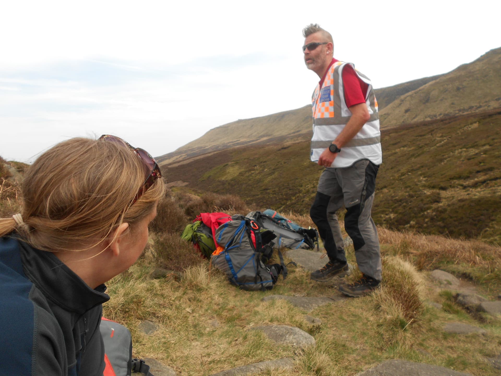
It seemed we really were up the creek without a paddle so with shame and regret I called 999. We were passed-on to the police but the signal kept dropping out. They asked for ‘What Three Words’ but I only deal in grid refs which they promised to relay on to the MR. Nigel of Glossop MRT called me back a short while later and the team were with us inside 90 minutes! It was an impressive reaction time especially when you consider they were 13 strong and first had to assemble. Then they had a fair distance to drive and walk up a rough path with heavy equipment plus there were two or three vehicles involved.
After questions and a form filled in for the hospital, Alan told me that they would stretcher me down. Preparations were made for this but plans changed when a radio call came in advising that there would be a helicopter.
Derbyshire, Leicestershire & Rutland Air Ambulance (DLRAA):
A little later the air ambulance could be seen circling the valley but when they tried to land some 50m away, it looked like they were unhappy with the quality of the ground, the vegetation or maybe the slope was too great. Alan of the MRT explained everything, particularly the prerequisite in the rules to fully land and to stop the rotors before a casualty could be embarked. The stretcher would be used to get me up there.
Despite the difficulties, the doctor left the machine to come down and see me! He confirmed the injury mainly from my description as there was nothing to see at that time. Besides I had three pairs of socks and an ankle support covering the injury. Getting that lot off and back on again would likely be painful as was removing my boot. For the same reason, I was apprehensive when the team applied an inflatable splint to my entire leg and foot but once it was in position and pumped up, I had no further twinges of pain whatsoever for the duration.
Landing Aborted:
Apparently because at least one wheel of its tricycle undercarriage kept sinking, wherever they tried to put the helicopter, it had remained with much of its weight held by its rotors most of the time. After maybe 10 minutes the doctor re-boarded and they were forced to leave without me. So close but yet so far away but whatever the result, a fantastic effort and a risky sortie by three people to whom I am very grateful.
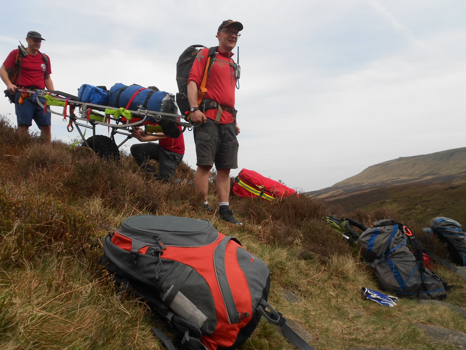
It was now down to the GMRT to complete the rescue using a stainless-steel framed stretcher with runners like a sledge and a single detachable fat wheel under the centre. I found out later that this had been brought over the hill by half the team rather than up the rough path with the others. I was wrapped in a fleece sleeping bag and secured firmly to the stretcher with 4 or 5 straps. A back rest, comprising a bag of soft equipment, appeared from somewhere.
The rough Fair Brook path would not be used for the rescue, it was explained. Instead I was to be taken NE up and over a 494m high hill, to pick up a little known track on the other side. This was the route used to bring the stretcher in. It seemed like a good plan to me but would still present plenty of challenges; chiefly having to regain height and the absence of a path.
With two of the team on the webbing straps at the front, two at the rear and two or three down each side, off we went. Nothing is ever done until after the shout, ‘Is anybody NOT ready?’ That enquiry applied to the casualty as well as the team members.
I held onto the frame but considering the terrain we were travelling over; steep, rough, undulating, pathless, strewn with tussock, clothed with heather, bilberry and with the odd hole to lose a foot in, I never once felt unsafe or uncomfortable. It reminded me of the smaller and seldom visited one and two point SOTA’s north of the border. I hope they all did a tick inspection on arriving back.
At first the wheel was employed but that had to be removed and reattached with its Velcro straps more than once depending on the terrain. I really felt for the team when they were faced with ditches and hidden holes in the ground and when the gradient increased significantly near the top of the hill but thankfully this wasn’t like Bleaklow which is cut by deep, energy sapping groughs. In that kind of country it’s best to seek out water courses to walk on bed rock.
I was going backwards and facing downhill. I could see Hazel and Finn struggling along behind. Her face showed a mixture of concentration and pain but she was going well considering her afflictions. It wasn’t what she’d signed up for. I’d promised her a relatively short and easy no-rush passage up and down the hill. Where she now found herself was very far from that!
Finn started coughing, presumably due to dust from the long heather clumps. Their escorting team member, taking a rest from hauling me and dropping back for a while, stopped to give Finn a drink of water. The kindness was extended to everybody including the dog.
Despite the sustained effort needed to cross this hill with an unwieldy stretcher, the team found the energy to chat to one another and to me too. There were stories of previous rescues and casualties weighing two or three times my twelve and a half stone. At intervals and in order to equalize the effort, team members would change sides, achieving this without putting me down. Only after the shouted enquiry, ‘Is anybody not ready?’ would we set off again.
At last the highest point was reached and I was turned round to face in the direction of travel. Apart from a bit of help from gravity, the task didn’t get much easier until finally we spotted the keenly anticipated track we’d been aiming for. Even then getting to the easier ground wasn’t straightforward. An intervening heather-lined ditch had first to be negotiated.
The track gradually improved from barely defined wheel marks in short heather to a wide smooth surface on short grass. With the wheel on and the worst ground behind them, the team were able to gather pace.
Around a kilometre later the down gradient increased markedly. Off came the wheel again and I was put down on the ground so that further attachments could be added at each side. I was urged to hold onto the handles and it was explained, ‘This is to turn left, this one to turn right and we’ll see you at the bottom!’ For a half a second I believed it. Looking down the steep hill, I could see a stream and a river. After a good laugh all round we set off again, this time using friction to our advantage by sledging but thankfully still under full control fore and aft.
I was wondering how they’d play it once we reached the water features ahead but there was no hesitation. Wet feet all round, not just once in Fair brook but again when we crossed the River Ashop. There were slimy rocks and hollows in the river bed so it wasn’t easy and I felt terrible again, cringing when I saw the girl on my right stumble and her foot shoot down. ‘Go on, tip me in; it’s only fair and it’ll ease my guilt’ but the stretcher remained steady. I was gently put down on the gravel area, temporarily ‘borrowed’ from the National Trust between the river and the A57 and where the GMRT Land Rovers were parked. It must have been a big relief for the team as it certainly was for me but for a different reason.
A few minutes earlier Hazel, Finn and their escorting team member had peeled off left to take the footbridge and path up to the A57 so that our car could be brought down to pick me up. I was asked if I wanted to keep the splint on, ‘We can get it back from the hospital later’ but they’d already gone to such trouble and didn’t deserve having to retrieve a bit of their kit from Chesterfield when their base was at Glossop. I would manage without. Knowing there’d be walking stick available at the other end, all I had to do was sit there for an hour while being driven.
The last part of the service was loading me into the passenger seat of the car. Two strong lads lifted me off the stretcher and I was soon in. My rucksack, which had been carried down by a team member with my left redundant footwear lashed to it, was put in the boot. Now the driver, Hazel was warned about the semi-blind exit onto the A57.
After thanking them - so utterly inadequate after what they’d done for me - and a promise to ‘send them something,’ They waved us off and Hazel drove me back to Chesterfield, where I ended up at the clean and friendly hospital A&E. I can only imagine how long it would have taken the team to put everything back to rights after the rescue but I’d wager that it was a lot longer than the hour it took us to get to the hospital. Something else to thank them for.
Chesterfield Hospital A&E:
After an examination the duty doctor confirmed my condition subject to a scan which he suggested I might have to wait a week for. As a compromise I was given a wad of paperwork by way of introduction to Scarborough hospital upon returning home. Before leaving a nurse fitted me with a special support boot, which proved to be an absolute Godsend in eliminating movement into the pain regions.
Scarborough Hospital A&E:
We were home by Sunday evening and at Scarborough A&E the day after. It was busy but because Chesterfield had completed the preliminaries I was straight in to see Dan the nurse practitioner for injuries, followed by the orthopaedic registrar Mr Briggs who examined me again. According to my wife, there was a red mark down the back of my lower calf where the injury was.
Dan fitted me with a pneumatic boot including a double heel wedge which I have to wear 24/7; the first boot being discarded. Shame, it was perfect. Two days later, an ultrasound scan confirmed the left Achilles rupture but they think it may not be fully parted. If there is some of it still intact that is an advantage because it will be better located for healing. I’m trying to be optimistic about the latter as I’d dearly love to be a SOTA activator again. They’ll decide treatment at a forthcoming fracture clinic appointment but it’s going to be a long time; in the region of three or more months. We’ll see?
OBSERVATIONS:
The GMRT:
This is my impression of the Glossop Mountain Rescue Team formed from experience at the time. They formulated a plan, informed me about it at the start and as they went along but kept it flexible as the changing conditions dictated. In my case, stretchering off changed to a helicopter evacuation but when the latter couldn’t safely land, it was back to stretchering off again.
There must be loads going on behind the scenes and in the organization that you don’t see but they are absolutely casualty-centric. At the same time they look after one another, never forgetting to check that everybody knows the plan and is in a position to carry out the next task often in unison or singly.
This close-knit group of people are as much like a large family as they are a working group. The camaraderie is obvious. It’s plain to see that they are highly trained and impose upon themselves the highest standards. They obviously know the importance of a good sense of humour, though at times it must be stretched to the very limits in malevolent winter weather, at night, on difficult terrain, on long hauls with seriously injured casualties or those with dire medical emergencies. That and the banter between team members was very reassuring to me and it also kept my mind off the situation that I’d found myself in.
I tried to get myself off the hill but the attempt proved itself tortuous, inadvisable according to 111 and my companion and close to impossible. Much as I wanted to avoid it, the need for external help was very real but that didn’t mean there was no sense of guilt or embarrassment in summoning and receiving it. The team would have none of it and acted to largely dispel it but it had taken a long time to come to terms with calling for help. ‘If you hadn’t called us, we’d have been out training soon anyway with one of us on the stretcher instead.’
Fortunately the weather was benign for this rescue, apparently the GMRT’s first one in 6-weeks but going cross-country to avoid a rough path wasn’t by any means an easy option. Mine wasn’t a medical emergency as such; more what you might call a mechanical failure. However it still rendered me immobile but once splinted I had no further pain and didn’t require any pain control. That allowed me to join in the conversation during the rescue and on some level to almost ‘enjoy’ the experience or at least feel a part of it. It certainly was a pleasure meeting them all despite the circumstances.
We all hope that we never need the Mountain Rescue Service but when I did, they were superb. That’s not to say that we should be blasie when going to the hills and not take the right precautions or equipment, so it’s best to read the advice on the MR websites. I had all the right equipment; my error was to take the wrong tendon!
The Air Ambulance (DLRAA):
Though I’ve been supporting the North-east version for many years, I’ve had no other experience of the Air Ambulance until now. Three crew members including a doctor tried their very best to land the helicopter but Kinder Scout was not playing ball that day. I think if the problem had occurred up on the plateau, there’d have been better options. The place we’d got down to wasn’t quite level enough. Helicopters are very expensive and in many ways, when they fly close to mountain terrain, quite vulnerable machines. They also have limited fuel/ flying time. Conditions need to be pretty well spot-on if serious risk is to be avoided but goodness knows they tried hard on the day for which I’m very grateful. The MR were on site and were able to complete the rescue so why risk a serious accident when wheels are sinking into the ground? Also they succeeded in one major way. The casualty was seen by their doctor.
The Impact:
All this is like falling off a cliff for me. I’ve been averaging 40 miles a week around home with Finn and now we’re down to nothing except hobbling to the toilet or a bit further. However it could have been worse. If the Kinder Scout sortie hadn’t intervened, this could have happened on Schiehallion or Ben Lawers in May and sadly, after putting those mountains on the air for two years running and pencilling them in again for '25, we have had to cancel our Loch Tummel holiday. If this had happened in far-flung Scotland I could have ended up many miles away like what happened to Nick G4OOE after he was airlifted off Ben Nevis with an injury. More importantly the MR rescue could have been even harder and possibly the weather more of an issue.
My XYL Denise has gone into ‘nurse mode’ - a former life - so I’m being well looked after but still doing what I can. She has been disabled for many years and now I’ve temporarily (I hope) joined her. After decades of ‘Wait for me John’ I struggled and failed to keep up on my crutches in a ‘race’ down the hospital corridor to the scan appointment.
Finn’s walk regime has degenerated into XYL-assisted, twice-daily toilet trips and a bit of a run, so it’s a good job Lurchers know how to sleep as well as run. By the 26th his owner will be fully moved and I’ll lose him. Having walked almost 7,000 miles since he was a pup and the same with Sasha before him, taken them on SOTA’s including summit camps, it will be a very hard day indeed. Hopefully I’ll see him from time to time and he’ll be staying with us for holidays. One can get too fond of pets even if they belong to someone else. After living nearby for the past 16 years, Hazel, Jack and Finn will be starting their new life. We wish them luck.
CHRONOLOGY on Saturday 12th April-25:
09:08: Left Chesterfield
09:58: Parked at A57 Snake Pass
10:10: Started walk
11:24: Left Achilles tendon snapped
11:42: Started a slow descent
12:31: Abandoned descent after 470m
12:32: Phoned NHS-111 for advice
12:53: Phoned 999 Police
13:18: Contacted by Nigel of GMRT
14:40: GMRT arrived on site
15:30: DLRAA Air Ambulance tried to land
15:35: Air Ambulance doctor attended
15:45: Air Ambulance abandoned landing due to soft ground (approx)
15:50: Stretchered off by GMRT (approx)
16:40: Arrived GMRT Landrovers - NT area nr A57 (approx)
16:55: Driven away by Hazel
18:05: Arrived Hotel
18:45: Arrived Chesterfield hosp A&E
21:45: Left Chesterfield hosp A&E
Distance & Ascent to injury point and back to rescue point
G4YSS: 2.6km + 0.5km = 3.1km (1.9 mls) / 250m (820ft) ascent
Hazel & Finn: 3.1km + 2.4km = 5.5km (3.4 mls) / 305m (1,000ft) ascent
THANK YOU’s:
To GMRT the Glossop Mountain Rescue Team .
Thank you is thoroughly inadequate in this instance but to Nigel; Alan; Chris; Torsten; Mark; Fletch; Gogs; Dave-1; Dave-2; Paul; Joanne; Steve; Andy; Tom; Katie and Amlee (I hope I have all the names). To all of you, plus anyone who I’ve missed and everybody in the organization – a massive THANK YOU. Just before leaving I made a promise which I will keep in due course.
To the Air Ambulance and its three crew members who attempted a risky landing including the doctor who attended – another massive THANK YOU.
To Hazel for driving me back to Chesterfield. The fact that for once I wasn’t on a mountain solo was important. You brought judgement and reassurance to the situation while we waited for the MR and Finn helped keep me calm too. I’m sorry you didn’t reach the top but I hope you’ll have other opportunities in the future. THANK YOU.
To NHS111, the emergency operator and the police. THANK YOU.
To the two walkers who offered to help me down when they were actually going up. THANK YOU.
For all the messages I’ve received be they from ‘radio people’ or otherwise; the first from G4OBK to the latest from Nick G4OOE and Dave G3TQQ. THANK YOU.
Apart from some night spasms and coping with the psychological effects that a sudden curtailment of mobility has on an active person, I’m OK at the moment but it’s going to seem like a long time. I can get around for short distances very slowly and mostly with the help of crutches or a stick and owing to the special boot, mostly pain-free.
Thanks for reading and I hope that nothing like this happens to you. That said, it could have been a lot worse!
Oh well, at least there are no radio logs to do.
73, John
G4YSS
…
Photos:
0101P-3-8-12-25-43-47-58-62-37H-1349P-76-77-78-44H-82-1530P-45H-48H-49H-51H-52H-53H-53a-54H-543P-545P-547P-54H-OS Map-A&E Boot-A&E Data
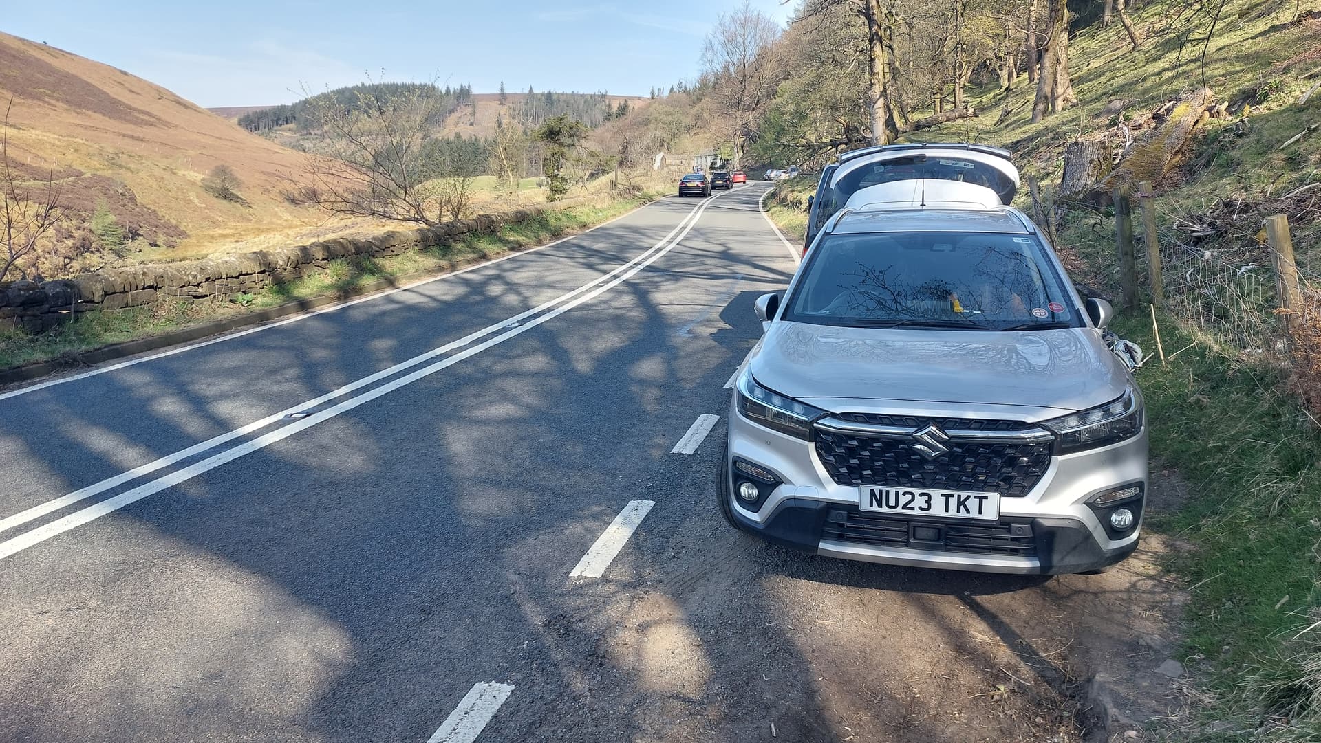
Above: A57 Snake Pass start point. What luck; just one handy space
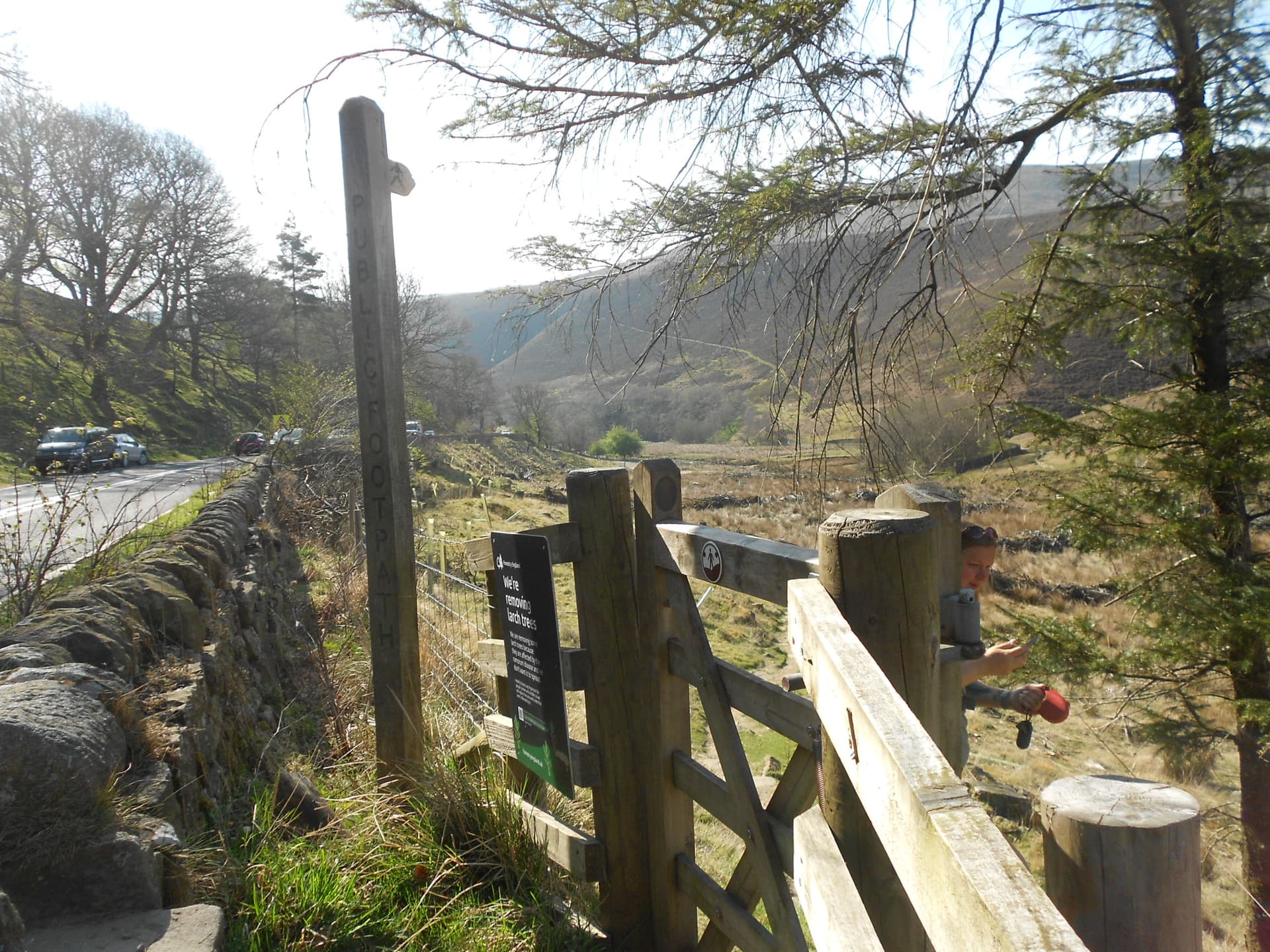
Above: The Fairbrook path leaves the A57 here. The Americans call it a ‘Trail Head’ which is not a bad description
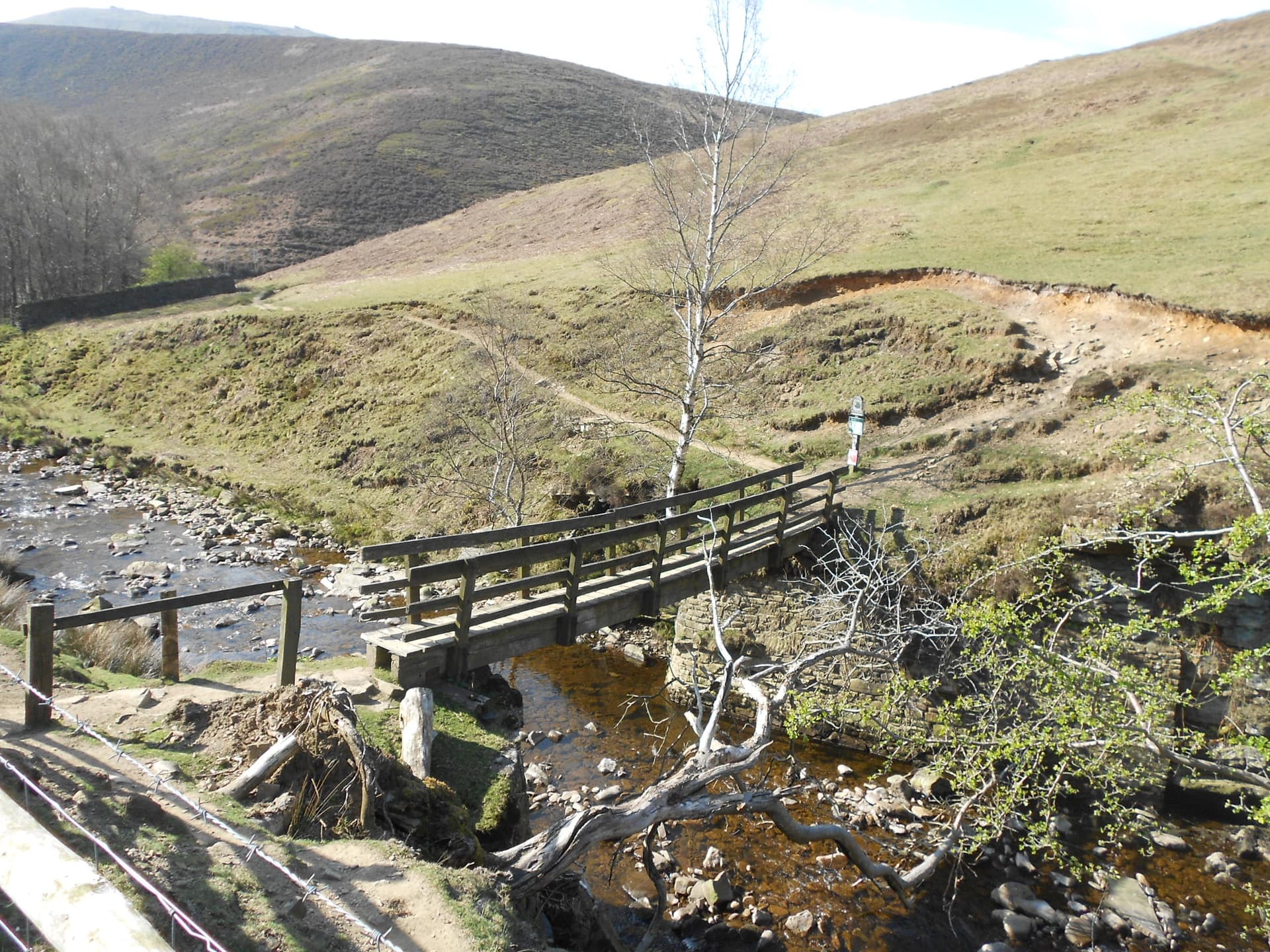
Above: The FB over the River Ashop
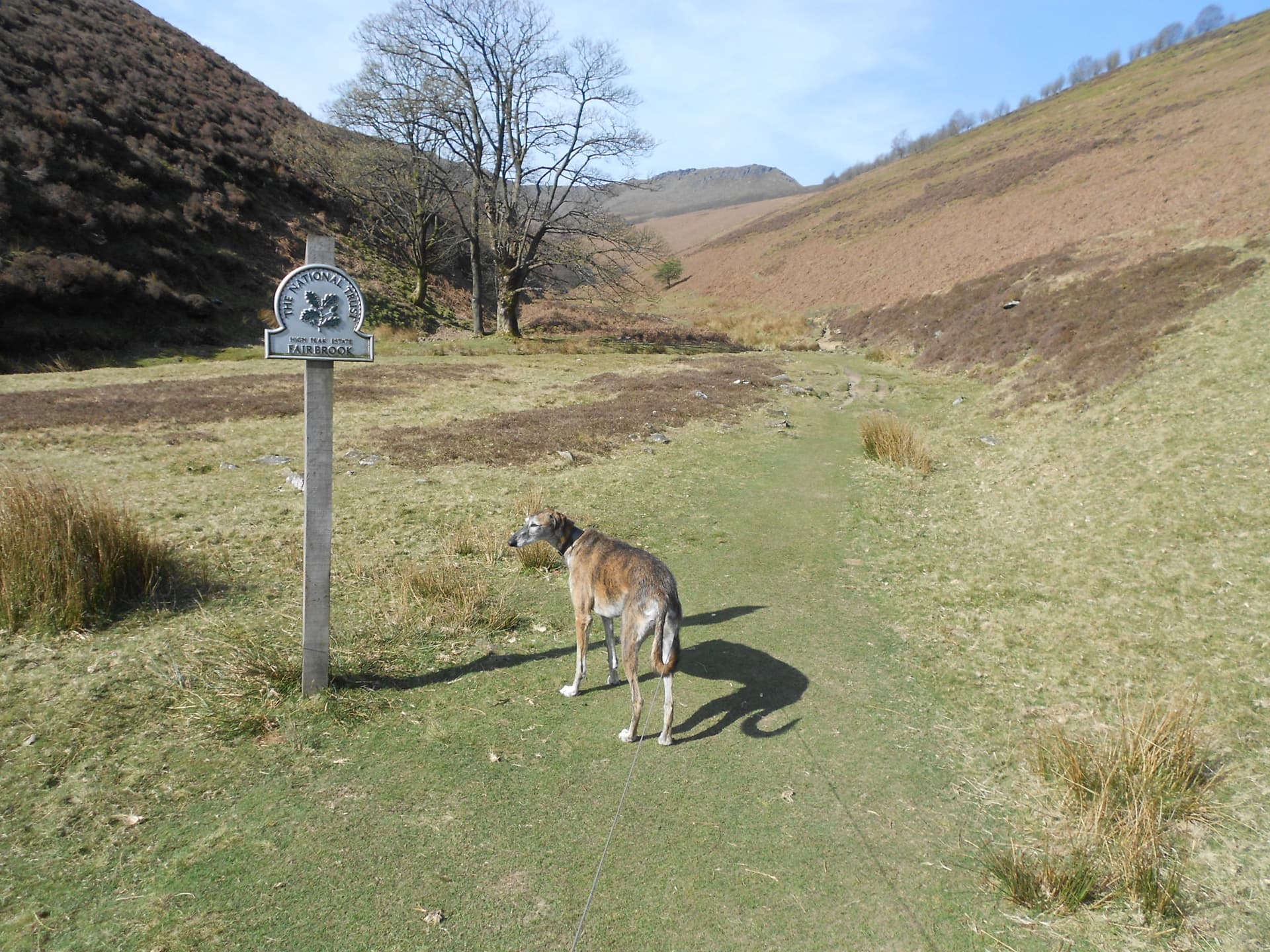
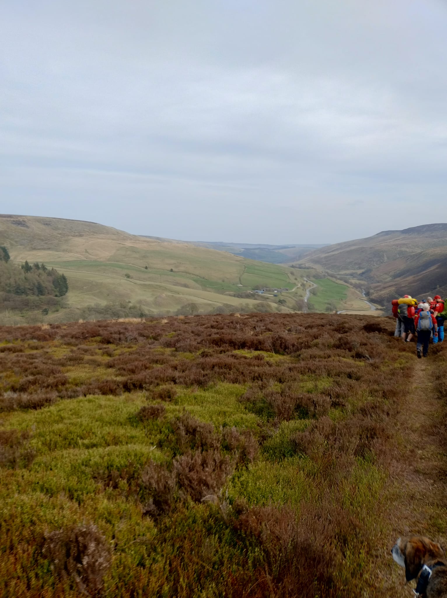
Above: National Trust, High Peak Estate and the start of the Fairbrook Valley
Above: Going well up Fairbrook on a nice day
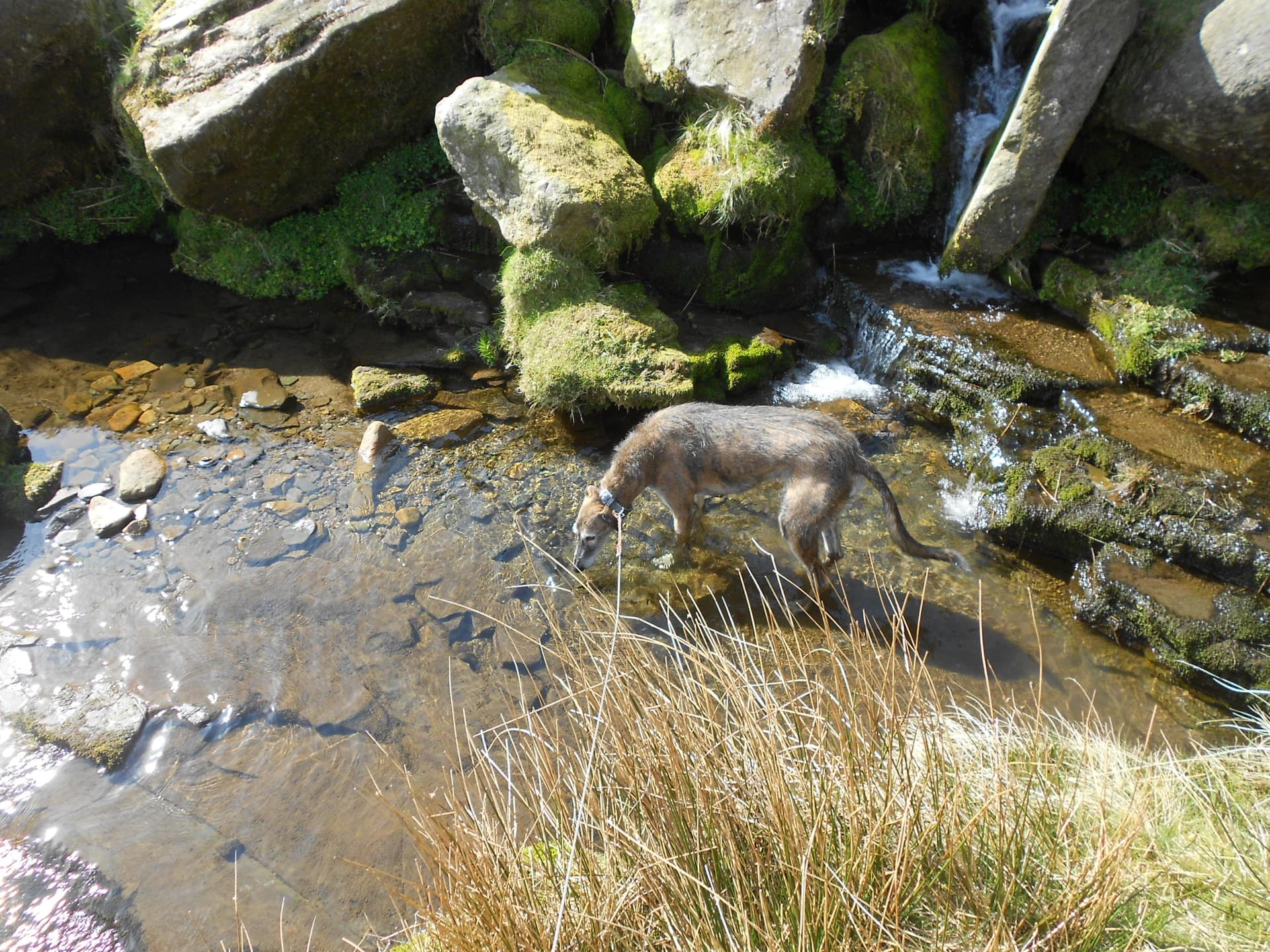
Above: Finn sampling the local ‘brew.’
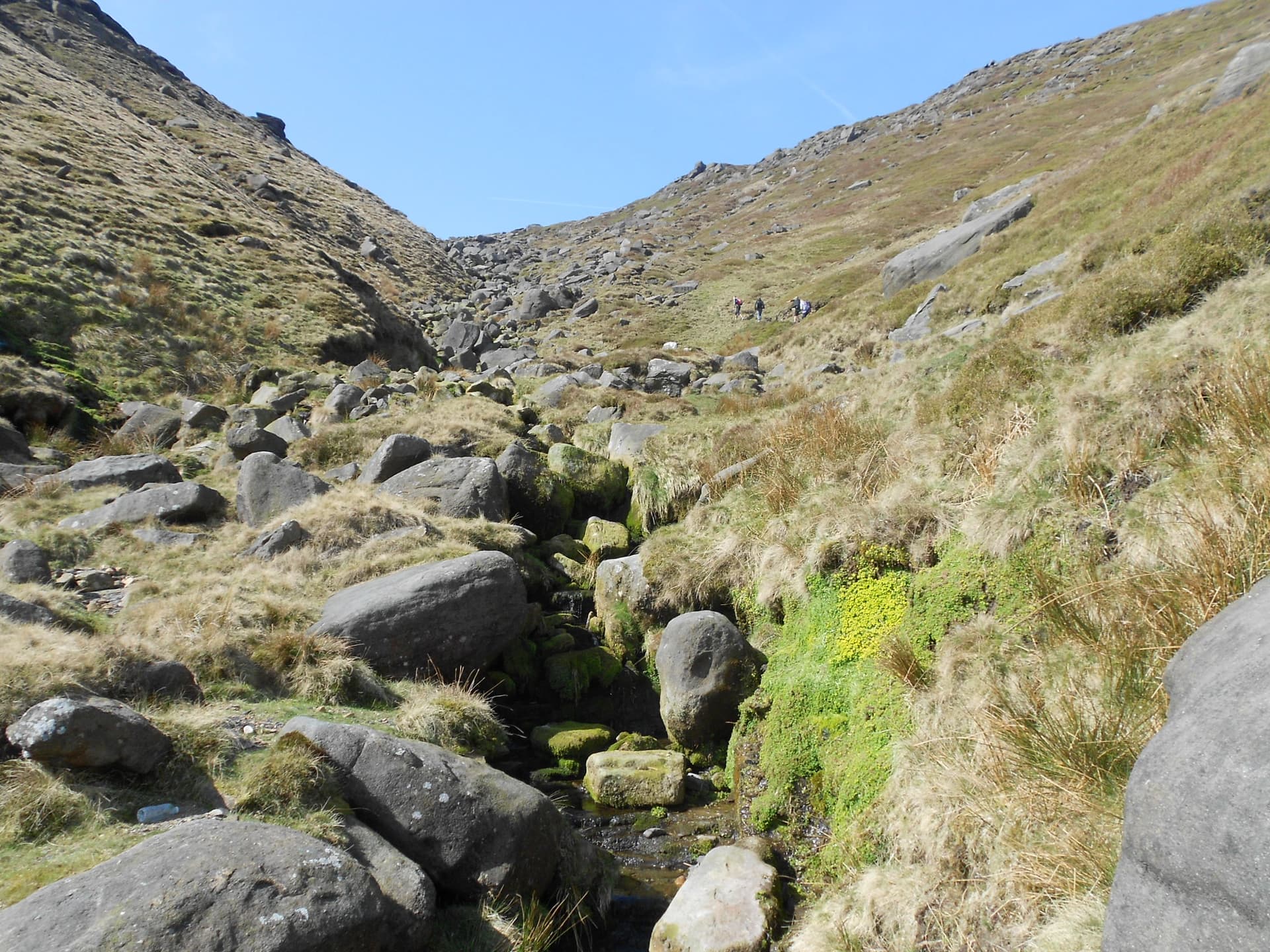
Above: Progress towards the valley head
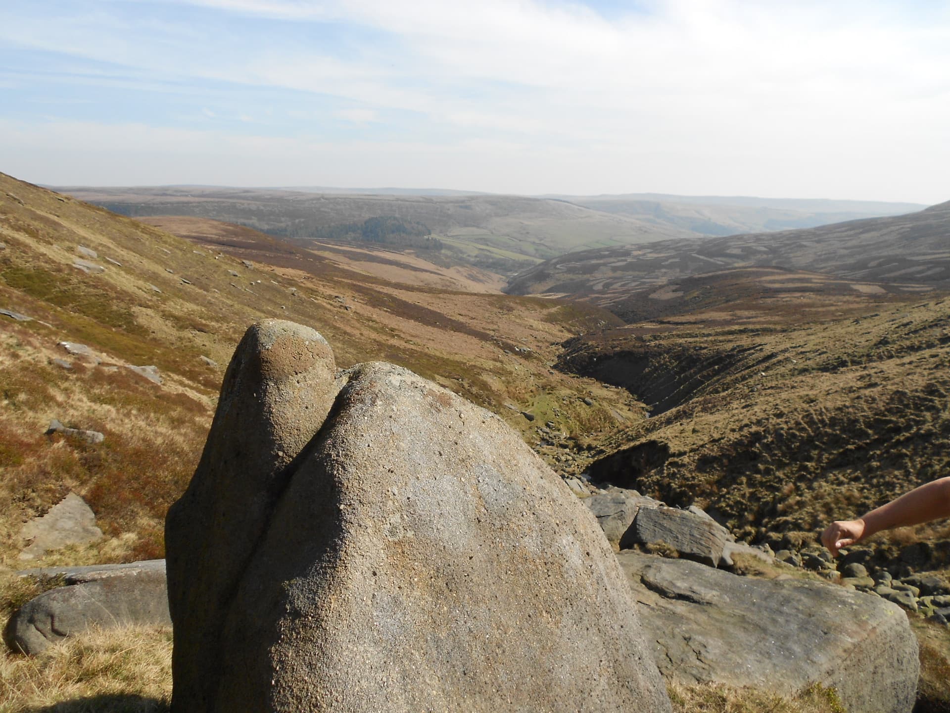
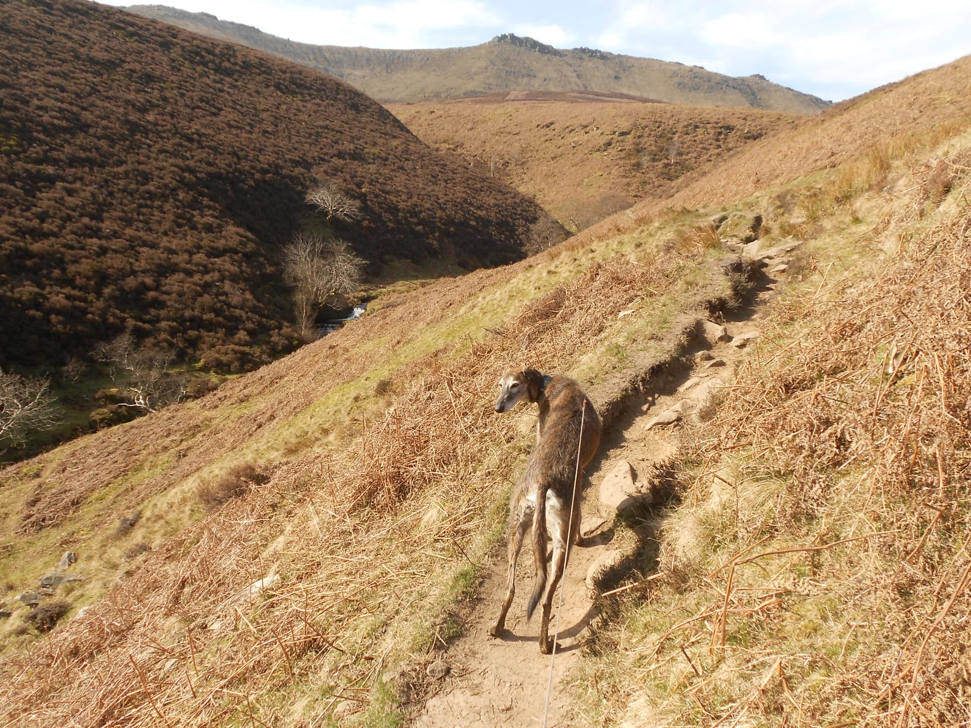
Above: Gritstone and the view back down the Fairbrook valley
Above: The scene of the crime
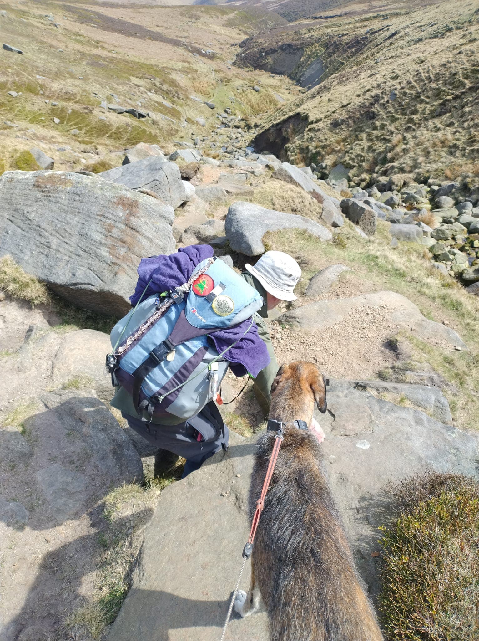
Above: Painful descent
Above: Here I finally give in and summon help. Waiting for the MR
Above: Injury position
Above: ‘OK, I give in’ / evacuation position
Above: GMRT - Glossop Mountain Rescue Team arrive in quick time

Above: Alan (left) one of GMRT’s First Aider’s attended to me and a form was filled in.
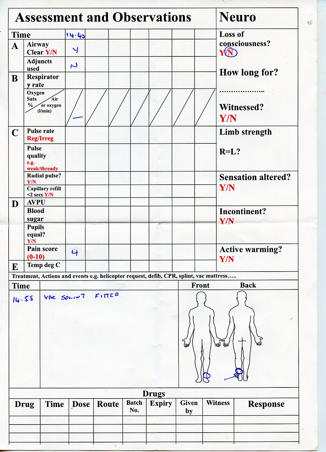
Above: Part of the accident form. This provided continuity for the Chesterfield hospital A&E visit that evening
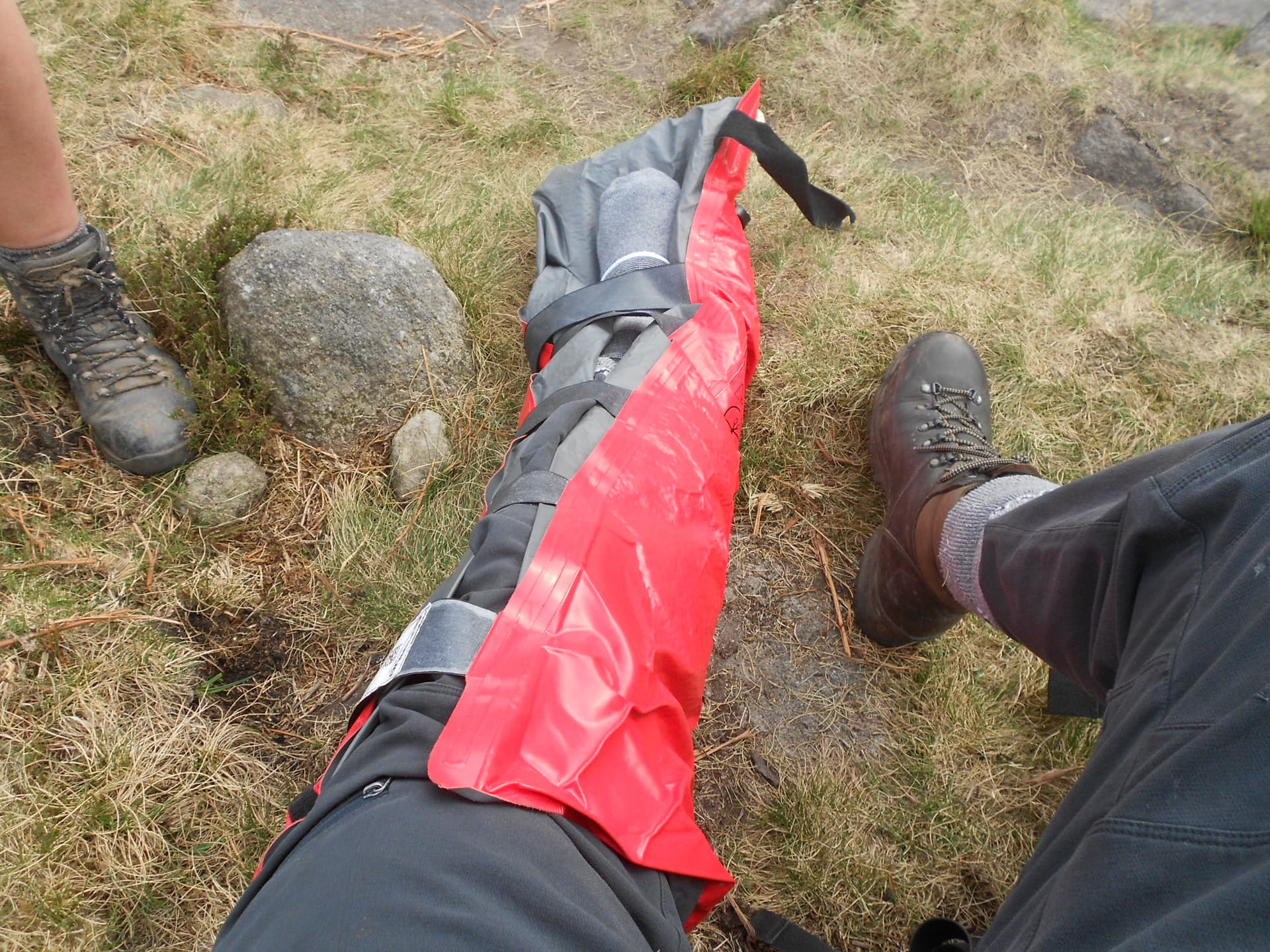
Above: Pneumatic splint looking ‘south’

Above: Pneumatic splint looking ‘north.’ Once this was on further pain was eliminated. Thank you MR!
Above: Transport arrives from the NE and over the 494m high hill
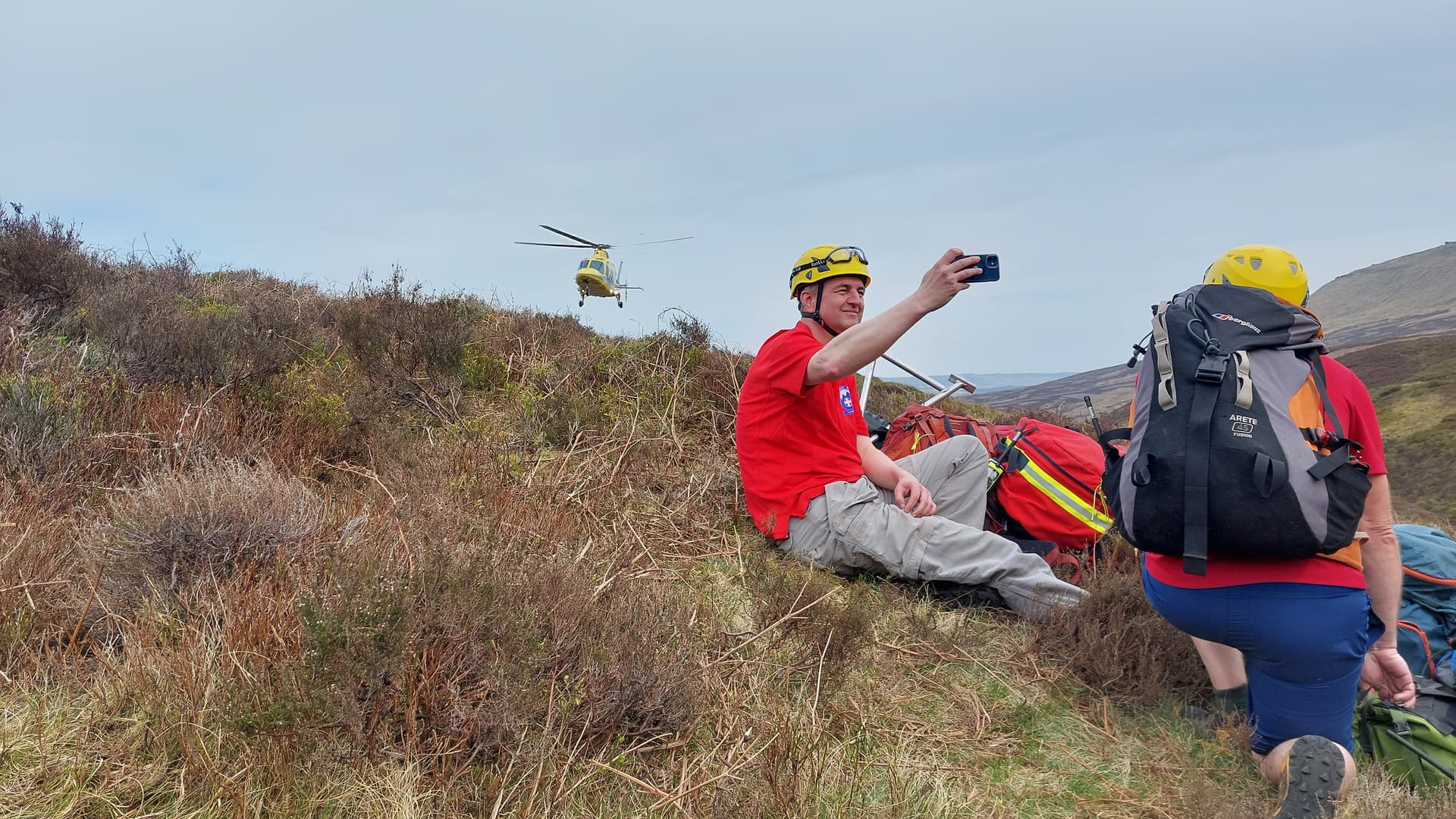
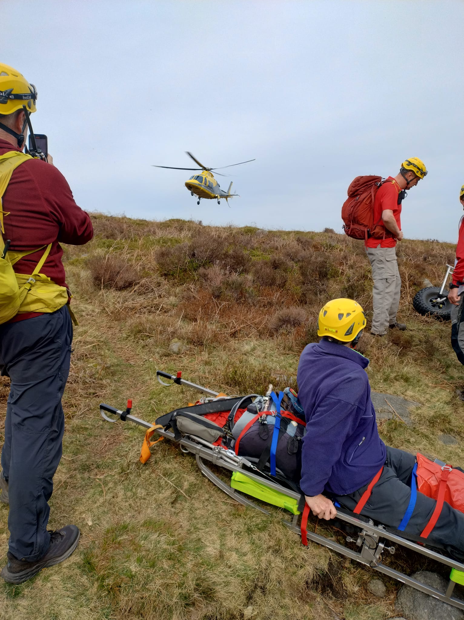
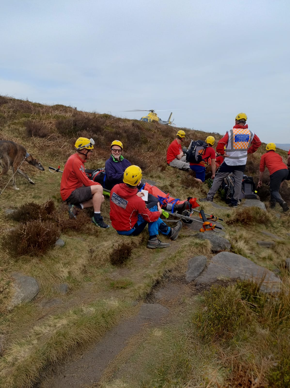
Above: DLRAA Air Ambulance seeking a safe place to land

Above: DLRAA had no choice but to fly away because of soft uneven ground but not until their doctor had risked himself to see me.
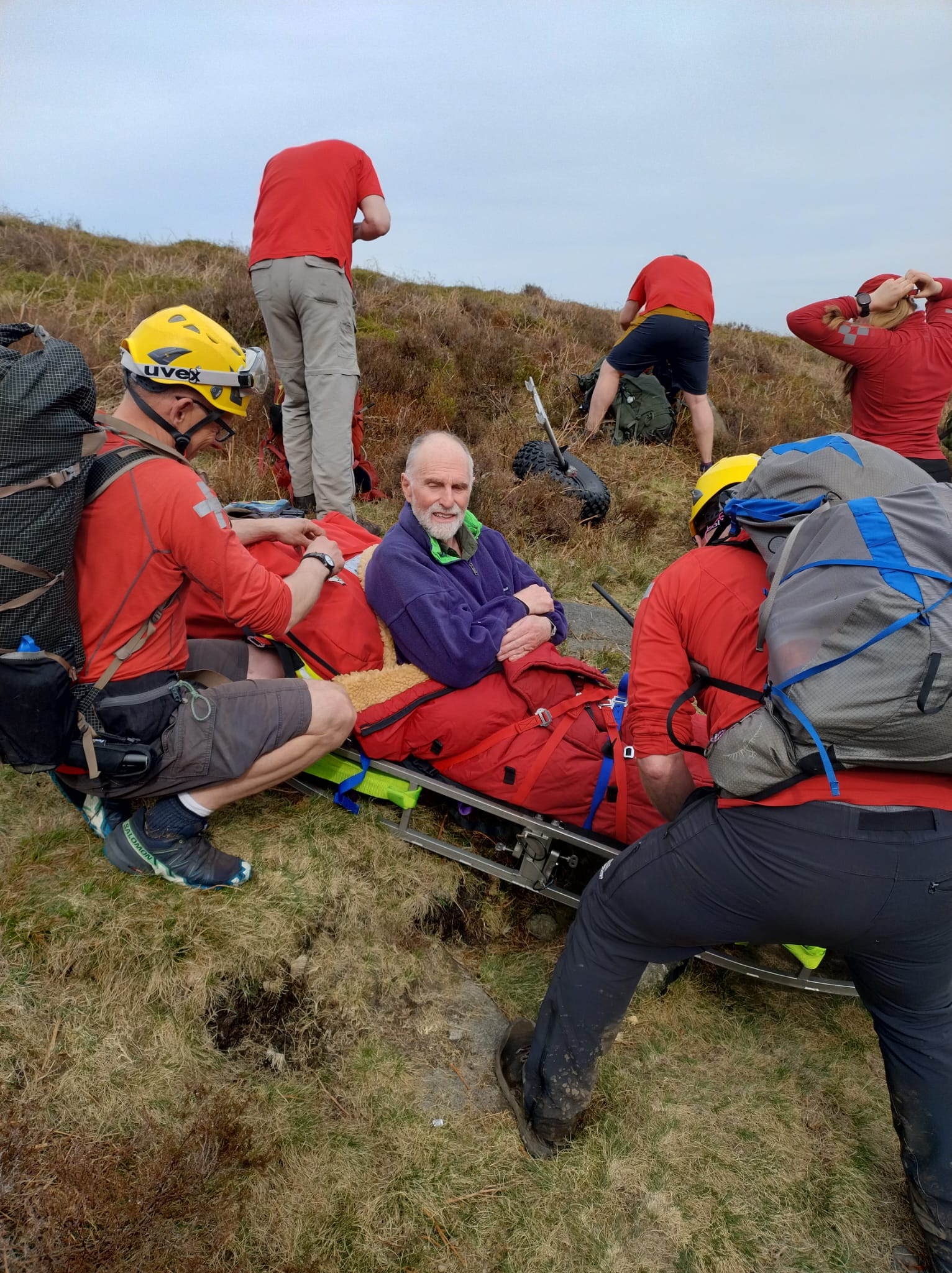
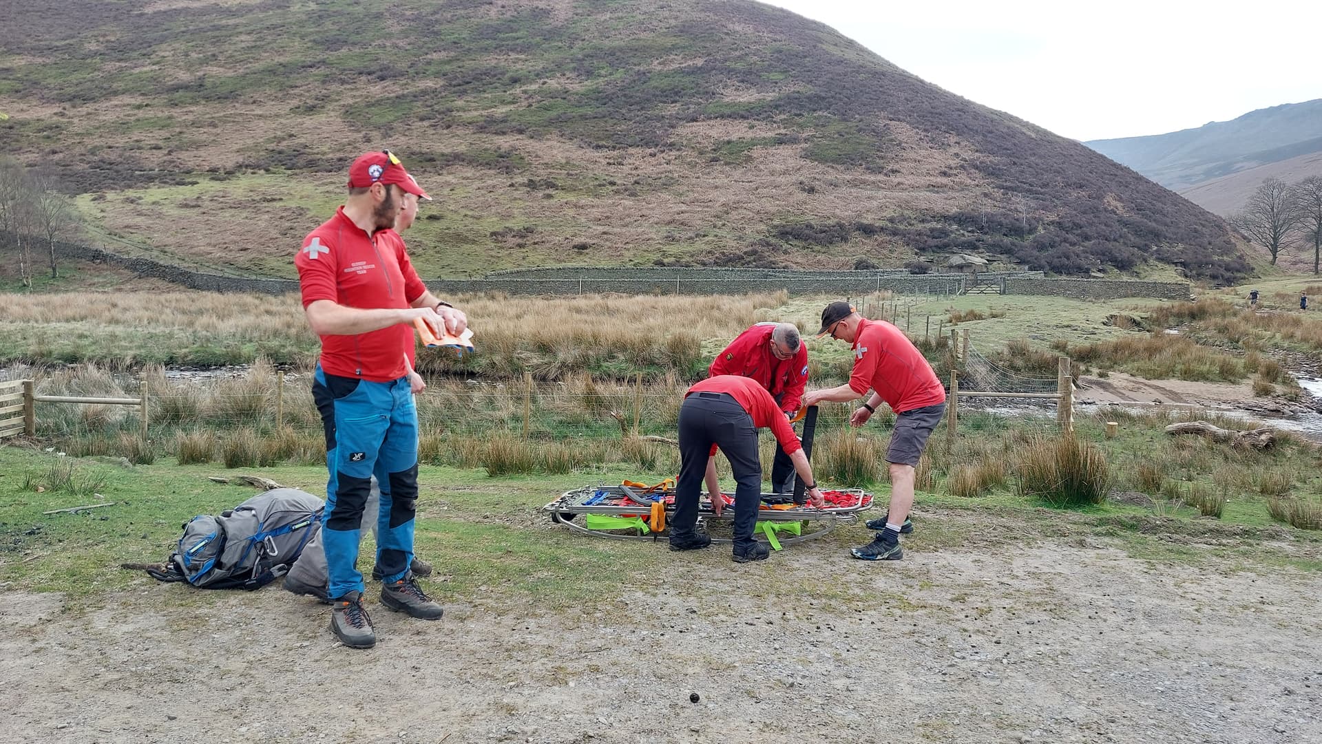
Above: Preparing for the GMRT rescue. Hard hats not now required
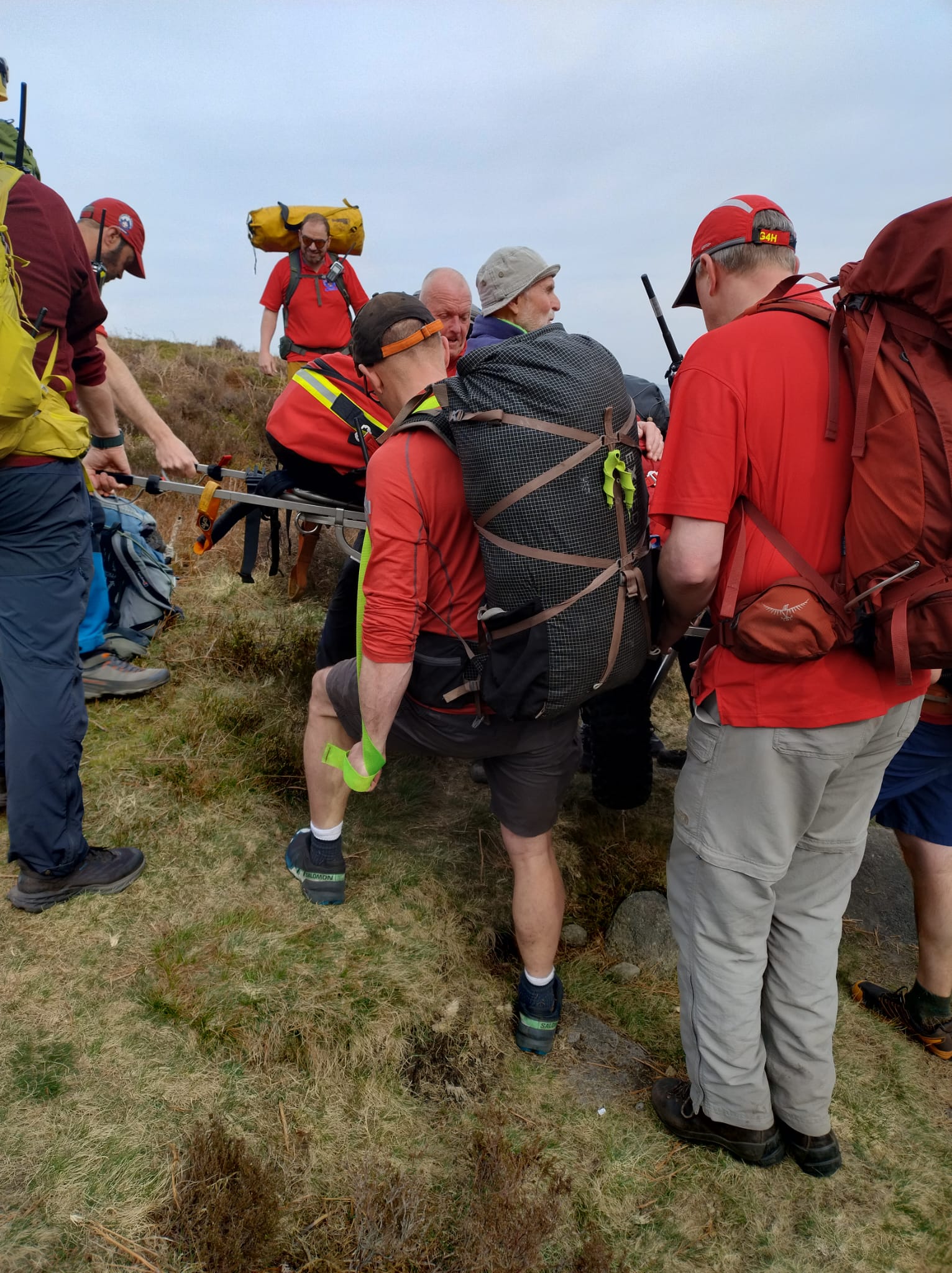
Above: Hard work begins

Above: Heading NE uphill to avoid the rough Fairbrook path

Above: The wheel had to be removed or replaced several times depending on terrain
Above: Easier ground at last. The track heading East and back down to the A57
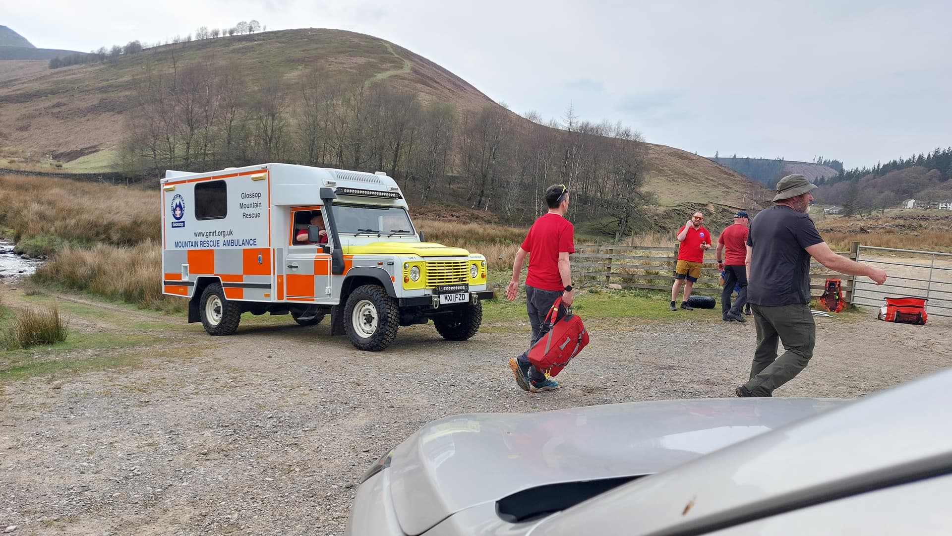
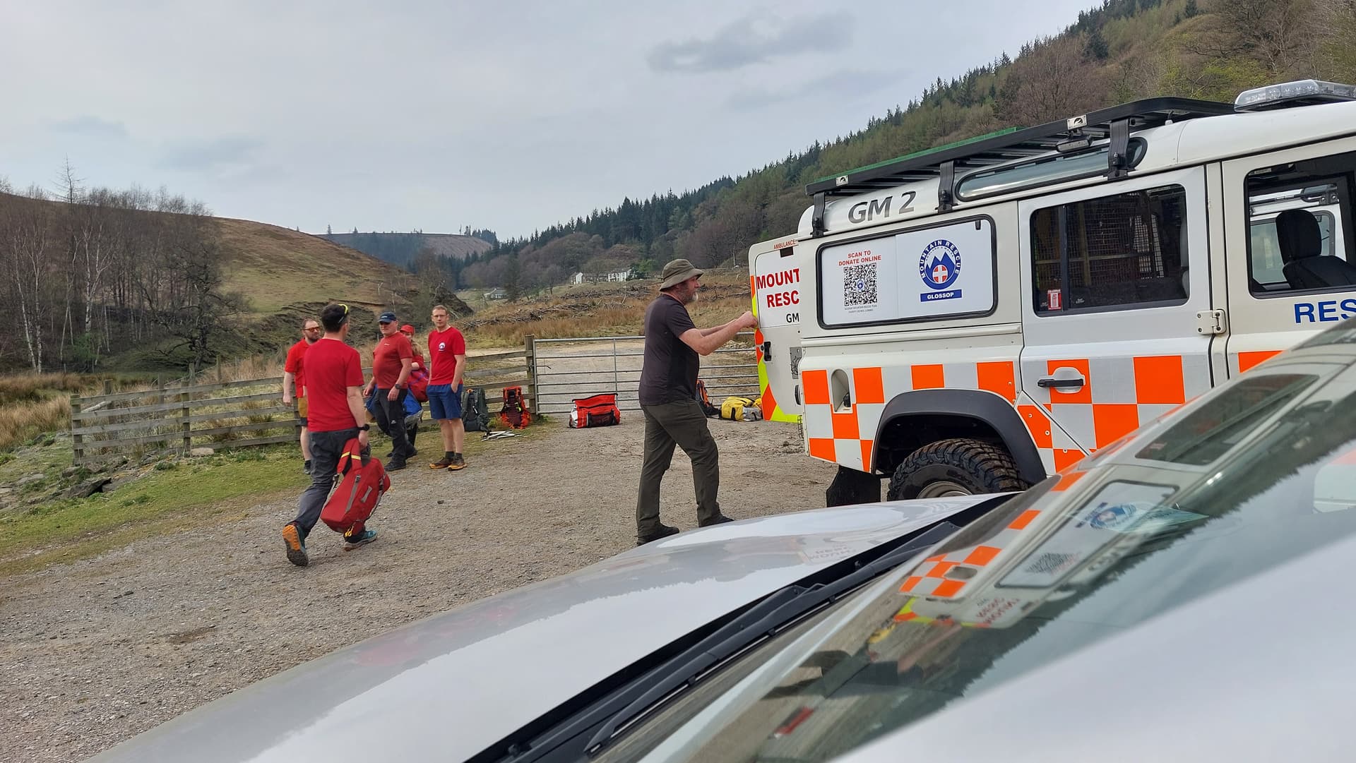
Above: Safely back at the National Trust area near the A57. My gratitude knows no bounds! GMRT members re-packing equipment for the next rescue or exercise
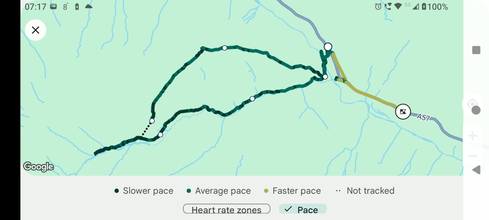
Above: Wrist worn GPS tracks. Lower track is the walk up the Fairbrook path in the morning. Upper track is the loop over the 494m hill. The stretcher route.

Above: 1:25k OS Map with stretcher route marked
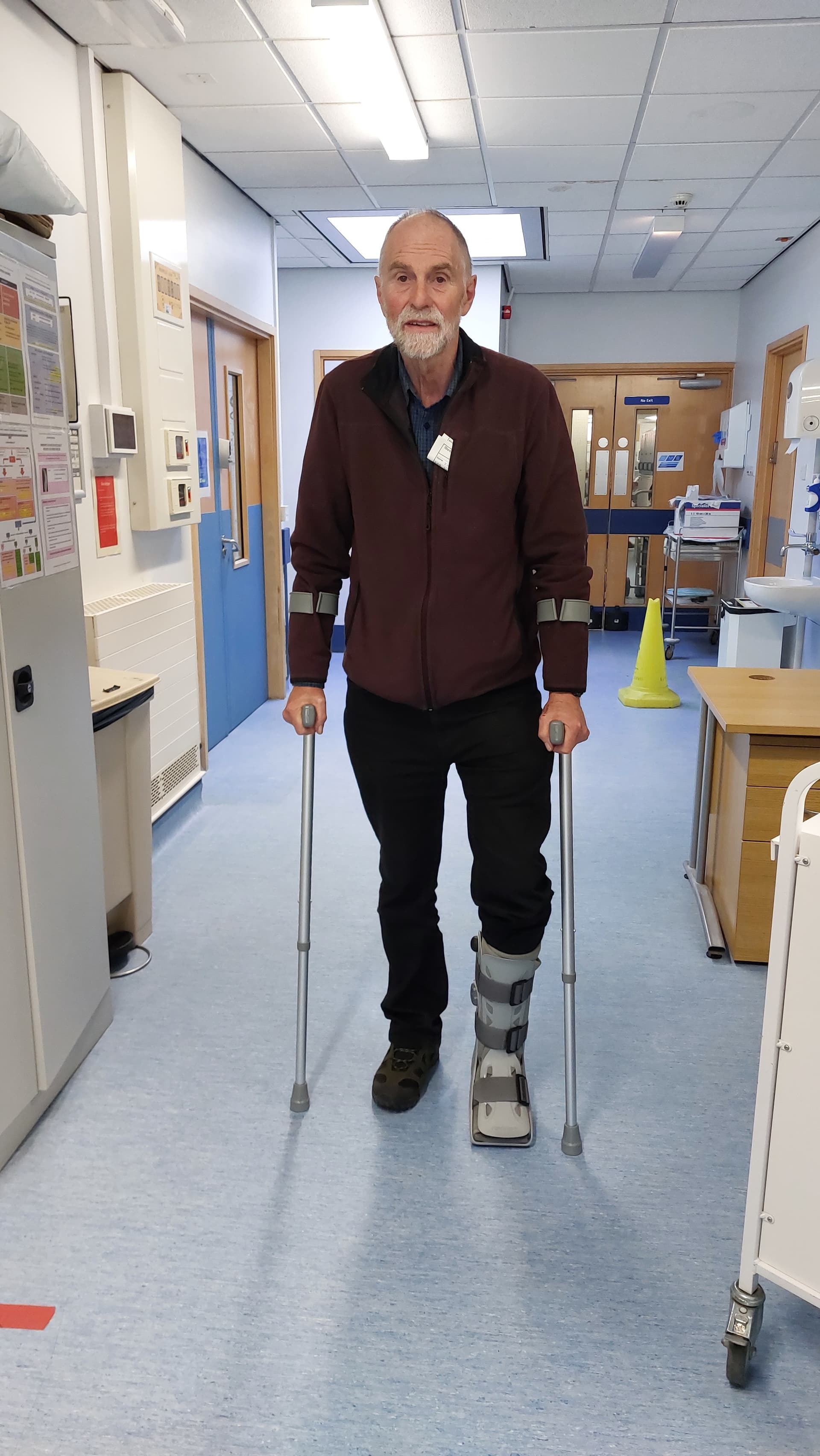
Above: A&E. New Boot & Crutches (reminds me of an Ian Dury LP). Pneumatic boot complete with valves and built-in pump like a lawnmower primer.

Above: A&E. Achilles Tendon break data sheet
Links:
GMRT:
DLRAA Air Ambulance
I can’t find a specific link for DLRAA. It seems to be general AA only.
This could be my last report for some time? If so, I may be able to find one or two historic ones from the early days of SOTA that were never posted.