I do have to confess to being a little obsessed with weather forecasts when planning an activation.
I use several sources, Windy Pro, MWIS, and Mountain-weather. Each seem to have there own strengths.
My wife ribs me as she looks out of the window saying yeah its wet, so must be raining
I have for sometime considered writing some code to pull the most appropriate data from the various API’s to feed my obsession.
Yesterday I was listening to a podcast on my ascent up Moelwyn Mawr, and there was some discussion about using Claude AI for programming. This prompted me to have a play with Claude AI this morning. I am actually blown away by its capabilities.
I have managed in a few hours to create an app that would have taken me a week or more to write, especially as its been 20 years since I have done any serious professional programming.
The whole experience and style of interaction with Claude has been like discussing a Functional Design Specification with an intern. They go away do some work, they come back and you say yeah but have you considered this or that.
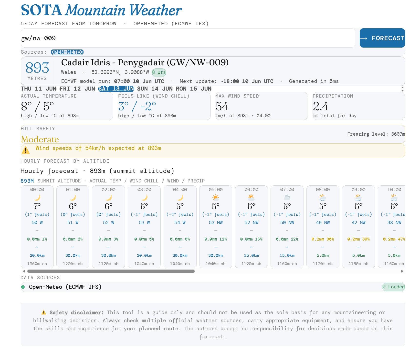
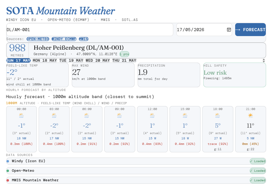
Now it’s experimental and only to be used for fun, but feel free to have a play with the SOTA weather tool. It’s only optimised for the UK and It is designed around what I want from a SOTA weather app. This may not suit your needs.
Spec Sumary
Summit lookup via sotl.as
Windy Icon EU for temperature and wind (pressure-level interpolated)
Open-Meteo ECMWF for precipitation, probability, weather codes, snowfall
MWIS for UK mountain area text forecasts
Wind chill as primary temperature with actual beneath
Freezing level calculated from pressure level temperature profile
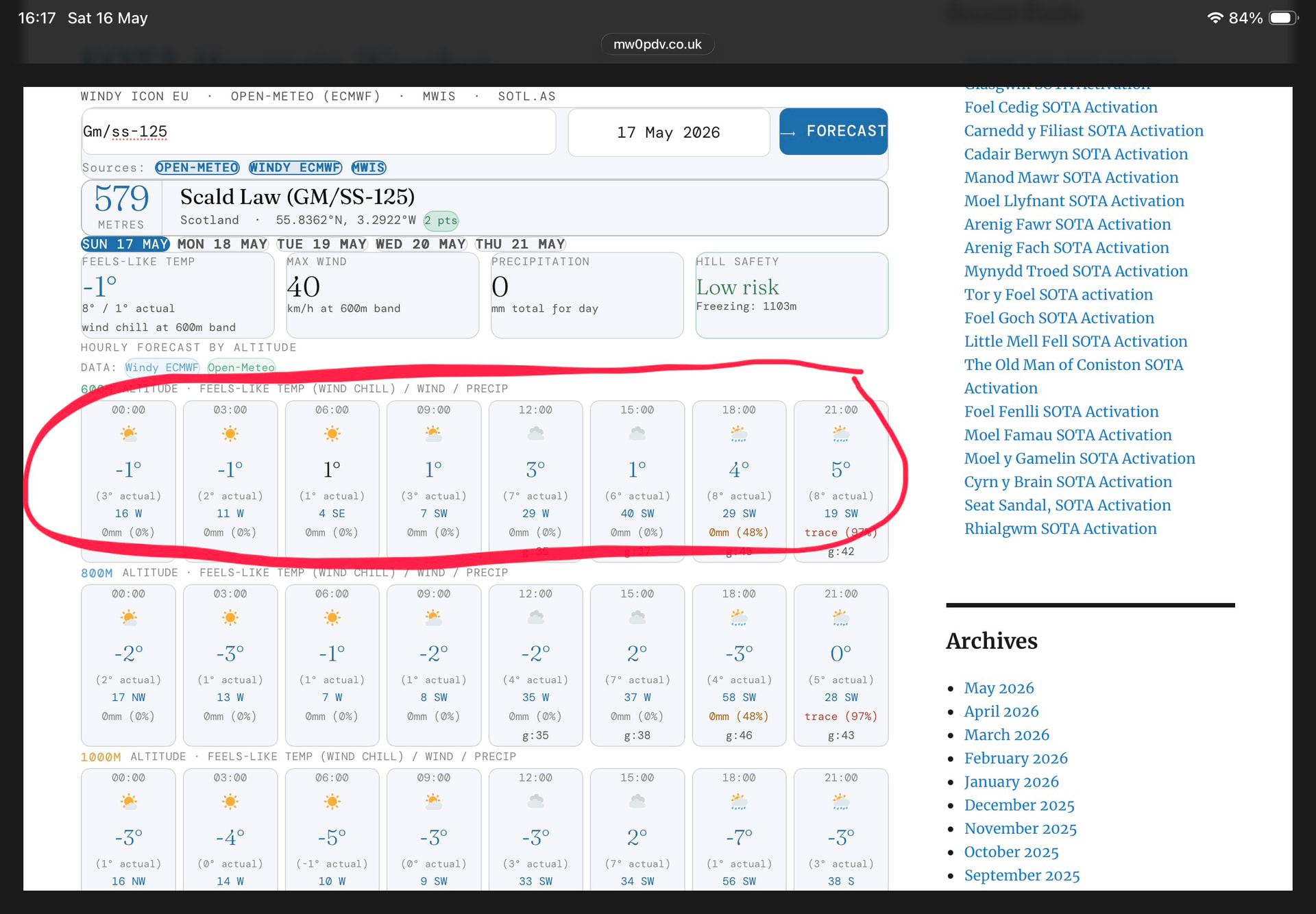
Claude would appear to be hallucinating. The forecast tomorrow for Scald Law tomorrow appears to be completely at odds to other forecasts. 50kmh stronger winds 15degs cooler temperatures.
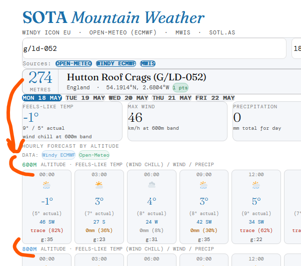
Currently I have set the lowest altitude as 600m, the summary uses the altitude band closest to the summit altitude. I can easily add a lower altitude band.
It not Claude it’s the old GIGO theory, the weather models I am using are the ones that I find most accurate. It’s pretty comparable to the Mountain weather forecast. This is exactly why I tend look at several apps and weather models.
The top summary are the extremes for the day, altitude band, in this case 600m is the useful row to look at.
It will be interesting to see how accurate this is. I looked at G/SP-006 for Monday and it reckons it won’t rain whereas the Met Office seems to think it might (although that’s for the area as they don’t have a summit forecast for White Hill.
Is there any need to give the weather at 1000m for a 545m summit?
I’d prefer the headline temperature to be the actual temperature rather than the feels like temperature. At the summit I will find shelter from the wind so the actual temperature is more useful.
For G/NP-028 the lowest weather it gives is for 600m but the hill is only 403m.
Yes working now thanks - actually I tried first a Lake District summit but then, even though, you said it was only optimised for the UK, I plugged in a German summit and it worked fine as well:
So for G/NP-006 I see a high probability for rain on Monday, but trace, this means, the amount is so small its rounded down to zero. So I interpret that as drizzle. Only time will tell, take an umbrella
This was the AI explanation when I asked how can you have 0mm rain at 95% certainty of rain, hence opting a TRACE label instead of 0mm
That’s the same model disagreement issue as before but more extreme. A 95% probability with 0mm means Open-Meteo’s weather code and probability model is very confident it will rain, but the precipitation accumulation model is predicting less than 0.05mm — essentially a trace amount that rounds to zero.
This is a known quirk of how Open-Meteo blends its models. The probability comes from an ensemble model that votes “yes, rain likely” while the deterministic precipitation amount rounds down to zero. In reality if probability is 95% you should treat it as rain regardless of the 0mm figure.
I normally manually compare and contrast the forecast from several wx services. Perhaps I’m getting lazy or infantilised but it seems quicker and easier to ask AI a carefully-worded question and get a very targeted answer. For example, just now I asked Google AI …
I intend to operate a non-waterproof amateur radio (FT-817) from the SOTA summit G/LD-052 (Hutton Roof Crags) between 11am and 1pm BST tomorrow? Should I take a tarp to protect it and me from rain? How heavy will any rain be?
Google AI’s response:
Yes, you should definitely bring a shelter or protective cover, as there is a strong chance of light rain or light rain showers during your activation window. While the precipitation is not forecast to be heavy or torrential, even a light, persistent drizzle will easily damage a non-waterproof transceiver like the Yaesu FT-817.
Tomorrow’s Hourly Forecast (Hutton Roof)
[hourly breakdown followed …..]
UK weather forecasting has seen exponential progress since 1987. A modern 4-day forecast is now as accurate as a 1-day forecast was during the infamous Great Storm.
In 1987, the Met Office supercomputer operated at a speed of around four million calculations per second—less power than a modern smartphone. Today’s supercomputing systems perform trillions of calculations per second.
In 1987, global model grid boxes were 150 km wide. Today, the Met Office global model works at 10 km, while the high-resolution UK-specific model divides the country into grid boxes of just 1.5 km.
Human beings suffer from confirmation bias, where you remember the exception (wrong wx predicted) and forget the vast majority of cases which were corrected. The Met Office continually compares its forecasts with actual observations to refine its models and get statistics on accuracy. Globally, its predictions rank consistently in the top two worldwide.
If only you’d post the whole story with the context Ian instead of trying to look clever. Do you think he would have continued doing that job for another 20 years if he’d had made the mistake you suggest?
Back in the 80’s and probably before (but I wasn’t doing stuff then that the weather mattered so much) we had a prediction tool that seemed to work about as well as the BBC forecasts.
“The weather tommorow will be much the same as today.”
So if it was raining in particular place today it probably would be tommorrow too.
Now I use Ventusky - Weather Forecast, Radar and Wind Maps | Ventusky as its precipitation tool I find to be pretty darn accurate. SO my prediction for Hutton Roof crags tommorow is that it will rain till about 11am and be fully stopped raining by noon with rain re-occuring by about 5pm. Wind speeds around 10mph gusting upto 20mph. Temperature around 10C but feeling around 5 due to the wind.
People blame or poke fun at Michael Fish the BBC weatherman for ‘getting the prediction of the Great Storm wrong’ but he was just the public face of a systemic forecasting failure caused by the limitations of the Met Office’s technology and data models in 1987, rather than a personal blunder.
Ooo, that’s handy to know. Seems like I should get set up around noon then. I’ll take the tarp, even if dry, if it’s cool and windy as you suggest, it can act as a wind break.
It’s only about 8km east-southeast of my house so I can use the low-tech method, walk outside and see when it stops raining.