I have a couple of quick questions regarding today’s W4K/EC-021 activation.
First, I mistakenly logged K6HPX under 14 MHz, but the QSO was actually on 28 MHz. I tried to download the log and correct it per the FAQ, but my ipad didn’t like the idea. I can delete and redo the log (only 13 entries), but wanted to ask about other options first. If it’s too involved, I can just delete/redo the log.
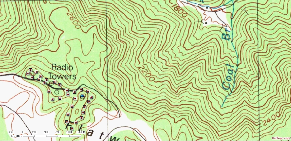
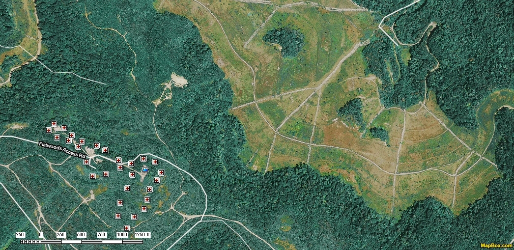
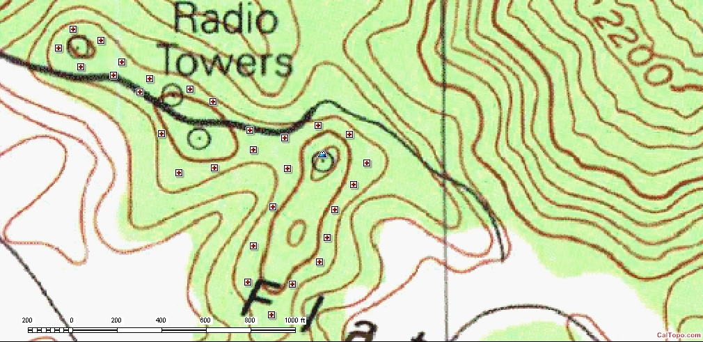
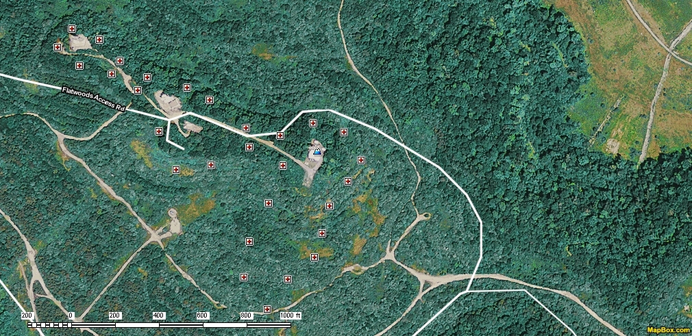
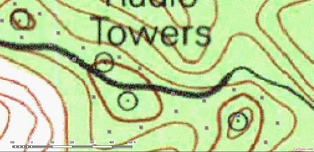
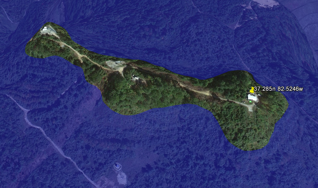
Second, it appears I didn’t get the exact summit on the hilltop. I’m within 40 feet of the listed elevation, but drove to the highest looking summit while on the hill. Am still within about 100m lateral and 40 feet vertically of the correct knob, but want to make sure I’m legal. From reading the FAQ, it appears the main criteria is to be within 75 feet/25m of the summit. I do easily meet this criteria. Discovered this after reviewing the satellite photos this evening. That summit is a haul over an old strip mine road and up quite a hill through a rutted/rocky road. At least it was dry today, a muddy road would be almost impassable, even with 4 wheel drive (except maybe Pat’s UniMog). It is a mountaintop tower site.
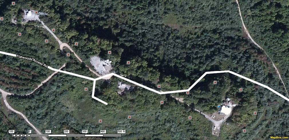
I actually set up (did take pictures this time) on the hill above the microwave relay station with the microwave horns on the tower, about 20-30m southeast of the microwave tower near the other towers/building on the hill above the microwave station. Couldn’t check the satellite photo once on the hill, but it looked about as high or higher than any other hills on the mountaintop while up there. So it’s very close, but wanted to ask.
Had to QRT early on 40m for QRM. Asked if the freq was in use before calling, and got no answers. Once chasers started calling, another station tuned up on freq and started claiming the freq was in use. Couldn’t find another clear 40m freq, so went to 20m. Maybe they could hear the chaser stations but not my 5w on the 817. Easier to QSY than give us a bad name. Will compile a better report later, got up way too early today. Forgot I was on holiday and thought it was time to get up for work. Very sleepy now, and will make more mistakes.
A quick note - The inReach and Iridium came in very handy the past couple of days to send spots where no cell service existed. A big thanks to Andy and all the other folks who worked to allow Iridium spots.
Hi Mike,
I sometimes have similar problems when trying to download, edit and upload a corrected log with my Android tablet. I often simply delete the log on line and re-enter it, especially if it’s not to big, otherwise I wait until I can get onto a PC to correct the data
On your second point, are you saying you were not at where the database gives the GPS coordinates for the summit, but at a higher point? In that case you are correct and the coordinates are wrong. The coordinates are only a guide and most of us look for a physical marker on a summit - a trig point or holy cross are often found, otherwise the highest point is the summit. If you operated within 25 vertical metres of the highest point (and there was no small valley of more than 25m deep between you and the highest point) you were in the Activation Zone (AZ) and hence the activation was valid.
As for the LID who starts up on the frequency you are on and then claims to “own” the frequency, that happens quite often. These idiots either don’t or can’t listen properly and your 5w was probably an S3 signal with him (or her) and for some operators that’s a clear frequency! You did right to QSY rather than try to argue the point, however having some chasers with BIG stations can help in these cases. We have to remember of course that no one “owns” a frequency and even if you were on the QRP calling frequency (shown in some countries’ bandplans) and someone running QRO calls there, there’s not a lot that can be done.
Here in Europe, it is also often the case that the 40m band is full, 20m is usually better.
As Ed pointed out. Sometimes a PC really is the best tool for the job. It is possible to download a log. Correct it. Delete the old log. Upload the corrected log. Deleting your log and entering a new one is the other option. As hard as it is to believe, NOT using an ipad is an option.
25 Meters is 82 feet. Your association ARM specifies 80 vertical feet (mine for some stupid reason specifies 100 feet). 82 feet is the number I keep in mind if I can’t be directly on the Summit.
I looked at your Summit on a Topo Map. I really can’t follow exactly where you were by your written description, but I am nearly certain you were NOT within 40 vertical feet. Quite possibly 80 which is still OK, but not 40.
The Summit coordinates are good. The database puts the Summit at 2860 feet. The Topo shows only two locations where that is possible, and the database coordinates put it in one of them.
I ran a ring of waypoints around the Summit at my best estimation of 2780 feet. Everything inside that ring is the Activation Zone (at least in this case). I extracted several marked up Topo and Aerial views and included them with the post. If you were inside that ring you were good.
Per AB3TQ: “Your association ARM specifies 80 vertical feet (mine for some stupidreason specifies 100 feet).” You don’t know the reason for 100 feet but you are sure it is a stupid one? Certainty based upon ignorance?
I would suppose that he would regard with some suspicion any significant unexplained deviation from the GR:
3.5.6 “It is recognised that operation from the exact top of the Summit may be difficult or even
impossible. It is also important that SOTA operations do not disturb the enjoyment of the
mountains by others. Accordingly, each Association shall define the Vertical Distance from the precise summit, within which a Summit operation will be considered valid. This Vertical Distance will define a contour outlining an Activation Zone within which a Summit operation will be considered valid. This Vertical Distance will normally be 25 metres. For other than 25m the AM must provide a justifiable case and also the MT may review this at any time, based on experience.”
The units used by SOTA in the US are expressed in feet rather than metres because Americans still use feet more than metres for measurements. We (mainly UK at the time) on the MT didn’t think we should force metres on to people who don’t generally use them. As a result of this the vertical limits and also prominence values were expressed in feet converted from metric and then rounded up. Well P150 becomes 492ft which is sensibly rounded to 500ft. ISTR 500ft prominence tables were available and this made getting summit data easier. Similarly 25m vertical limit came out at 82ft and again we thought 85ft or 100ft sounded better so that was an allowable value.
All well and good, look at how popular SOTA is in the US, just about all the US is now in SOTA and Alaska is coming. Everything in the garden is rosy!
It was Bruce W7RR who pointed out that by picking 500ft rather than 492ft, an 8ft difference, meant that the US associations have stricter limits than metric associations and as such there are a substantial number of missing summits in the US associations because of the 8ft round up compared to if they had 492ft. Seems a bit unfair.
The MT have expressed many times that we want things to be equal across associations so US associations will be allowed to properly “metricify” themselves if they want. i.e. move from P500ft to P150m and 25m limit. I recall Bruce saying there are nearly 700 summits to add over the whole of the US so I can understand US hams being keen for this to go ahead. So the limits will become the metric values but you can still express them in feet of course. There will be no rounding. That will allow all US associations to get in step with the same numbers.
This is a fairly big (and boring) chunk of admin and it has to fit in with the overall summits team workload. We have some big tasks running, ZL South Island, Alaska and resurveying Italy. So you guys in the US will have to have some patience but you will all get a chance to have your association updated during 2016 and early 2017.
The US topo maps with the best resolution often use a 20 or 40 foot contour interval in the mountains. There is a bolder contour every 100 or 200 feet, respectively.
That means an 80 foot or 100 foot activation zone is a good match to our maps.
Mike, there are problems with the database menus with both iOS and Android. It needs fixing but is less than simple so it has been pushed down the list. If you know the webpage URL you can save them in your iPad bookmarks and that lets you navigate. You have to use a PC to find the web URLs however.
If you can navigate to your log (by using URLs you previously found) then you should be able to download, edit and upload the file on an iPad. It’s a bit of a pain but can be done. Maybe something to play with over the Christmas break when you need to find something more interesting to do that eat, drink and watch the TV (typical UK Christmas activities!)
Well there are a few users using the InReach now. The code to handle their messaging is all my own handiwork but a word of thanks is due to Martyn M1MAJ who asked me to look into supporting them and then did some work to help others configure the InReach unit so it was compatible. I had a real problem with messages from Victor GI4ONL’s unit going AWOL that took some sorting but it’s OK now. That was an issue between various telecoms companies all saying their side was working and it was someone else’s fault. I changed to using Google Voice to handle the comms and it all started working. Google have some real privacy issues that become distasteful after a while but they do offer some damn fine technology for free. OK, not free but in exchange for your privacy and soul!
I had tried to create a flood previously and couldn’t even manage to coax out a rain cloud. Your Flood looks great, but do you have an explanation for the obvious disparity between your Flood and my Topo Map?
That higher altitude area that my Topo show directly south of the Summit, you are showing under water. While I see total agreement west of the Summit, one of the methods is wrong to the south. Which one, and why? I have to be honest that I do trust visual evaluation of a Topo Map head and shoulders above any automated Google product. But I do have an open mind to evidence.
Actually, there’s a third option, which is both are wrong. Google Earth terrain data is based on SRTM, which is reasonably accurate, but has errors that can be produced by shadows in high mountain areas, snow cover, tree cover and simple “where the hell were we in that orbit?” errors. I’ve seen figures of about 30m absolute accuracy vertically, with the majority +/- 10m, but I can’t find that reference now that I want to quote it.
On the other hand, Topo contours are produced from hand surveys and aerial mapping. Surveys typically do not have the resolution that, eg, SRTM has, but the elevations are likely better accuracy at the points at which surveys occurred. In between, well, that’s the cartographer’s best guess work. Maps with regularly spaced contours are a giveaway that the cartographer is guessing. I’m almost certain there’s a lecture series in any cartography course about how to make stuff up in a manner that doesn’t make it look made up. Aerial mapping is has higher resolution, but still generally requires interpretation by a skilled cartographer.
So, there are errors in every bit of data - you can trust neither to be 100% accurate. The only answer to this would be to send in a survey team to do a high resolution survey whose sole purpose is to measure the contour 25m below the high point. Even that would state an accuracy level +/-. There are a group in the UK that do this for prominence for Marilyns, their reports are most interesting to read if you have that kind of bent.
Folks, thanks for all the great info. First - I’ve reloaded the log, so that part should be good now. Do have a PC at home, but the iPad is easier for traveling. Have also added an activation report for the summit (W4K/EC-021) that tries to provide better detail. And that Google “flood” feature is really impressive. I did examine my spots sent via the inReach, and the most consistent inReach GPS altitude averages out to 2824 feet (based on the data sent by the inReach unit sitting on the old steps by my radio). And add the fact that the area has been strip mined, and the older topo data discrepancies are understandable.
When I activated W4K/EC-020 a few months ago, the GPS settled down showing me sitting down over the hill, even though I was obviously sitting on the top. Of course I didn’t know the survey date from the Delorme topo charts on -020, nor was there a bench marker/trig point available nearby. Also didn’t know the datum used in the original charts (WGS-84, etc.). So some topo error is understandable.
I’ll try uploading some pictures in another reflector post, can’t make it work on a reply. But they will be reduced size photos.
Thanks again to all for all the info and the work to allow inReach spots, that capability has been really handy.