A question regarding activating a summit where the summit has been re located. Botley hill used to be where the trig point is, in a farmers field just off the road side. It has been re located to where the NATS mast and water tower are, some half mile or so away. Is it still OK to activate from the previous summit location? As when activating on Good Friday, a local dog walker informed me that driving up to the new location wasn’t allowed as was on private land and that Police patrol the area as its a NATS site. I know that driving up to a summit is not playing the game, but there are a few that have vehicle access. Also, if activating from the old location is not possible, then activating the trig point would be impossible. Thanks Dave G8XDD
Hi Dave,
Never having been in that part of the country I had a look on the OS map and as far I can see you can still activate from the trig point as it is still within the activation zone, although a wee bit away.
As for the other questions you ask, I’ll let the English answer them. Us Scots have different laws than you do.
73 Neil
Hi Neil, ok thanks, I was hoping that was the case as I think quite a few still activate the ‘old’ location
The new summit location and the old one both lie within the present activation area, and I don’t think its shape changed much when the summit was re-located.
The summit is at 269 metres, so I think the SOTA activation area would be enclosed by the 244 metre contour. At one scale, streetmap.co.uk provides contours at 5 metre intervals, and the 245 metre contour is close enough to be useful and on the safe side.
The activation area is huge. To the east, it stretches as far as the “Clarks Lane”/“White Lane”/“Approach Road” junction (and up “Approach Road” about as far as that little zoo). To the west it goes as far as the turning where “The Ridge” turns into “Northdown Road”. To the north it ends at the point where the track called “Upland Road” joins “Croydon Road”. It covers parts of IO91xg, IO91xh, and JO01ag. While most of it is in TQ35, there’s part of it in TQ45.
The catch is finding a place that isn’t on private land, but I figure the car park with a view above the quarry is probably a valid spot…
When we relocate a summit we look at the old and new activation zones. If we find that the old AZ is not within the new AZ we give the new position a new reference. So, if the reference has not changed the old position is still good for the AZ of the newly-determined actual summit.
Here, for anyone interested, is my low-tech see-where-it-is map of the Botley Hill activation area…
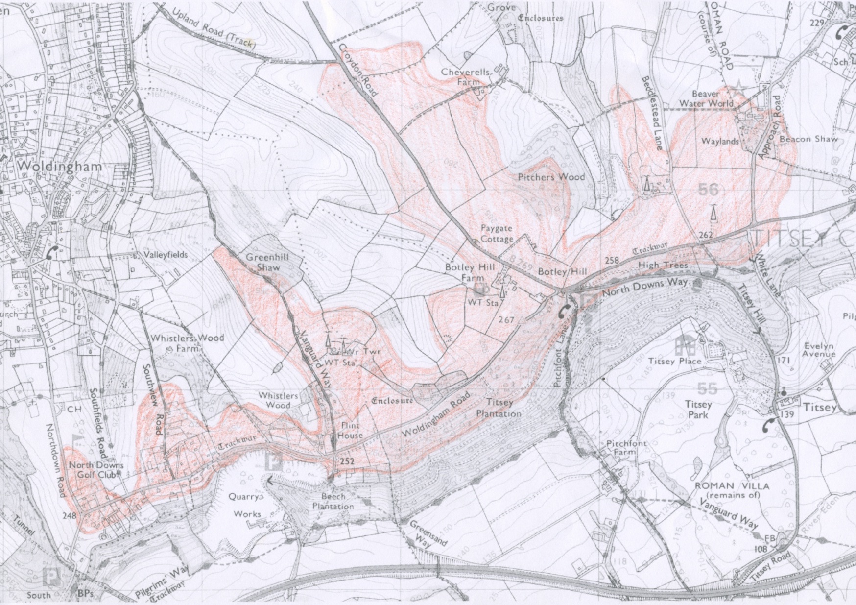
(Based on OS data which is ©Crown copyright 2018 Ordnance Survey. Media 032/18 )
Thanks for all the feedback on this, greatly appreciated. Dave G8XDD