You may or (more likely) may not have heard about a new amateur radio ‘On The Air’ program called LLOTA, aka Lakes and Lagoons On The Air.
Anyways, it’s a bit of craic and another activity for portable enthusiasts to get stuck in to if they wish. I’ve taken on the role of Country Manager for Ireland and spent the last 62,387,912 years cleaning a public data set so I can start adding entries in to the LLOTA mapping system.
It was while doing this that I wondered if there were any summits in EI that had a lake or lagoon on them.
And sure enough…
Anyways, point being LLOTA is something you might fancy for a SLLOTA twofer (case in point above). Hope it tickles a few pickles.
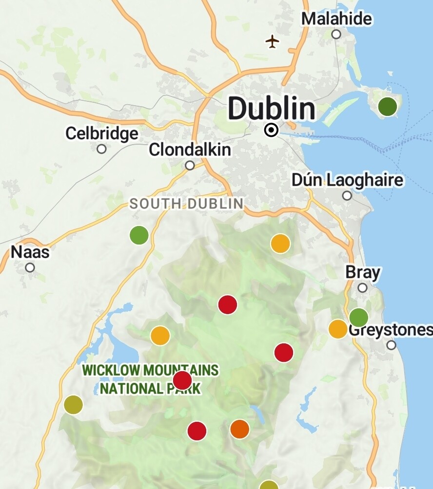
The map is here, I’ve added all 183 locations (and counting, I’ve about 4400 still to do plus 88 lagoons to add) in EI and there is another user adding locations in the UK too if anyone is keen (plus worldwide as well of course)
Just thought to share in case folks might be interested is all.
Oddly enough I did get a TOTA reference come through the other day but I hadn’t a clue what the fella was on about so didn’t note the TOTA reference.
I’d wager there’s some SOTA/TOTA/POTA/LLOTA/WWFF multipacks available in places like Switzerland and Romania. Maybe even some COTA and CHOTA crossover too.
Better check for copyright infringement - a few years back, “Sewage Lift Stations on the Air” was a thing. Cannot recall if they went for “SLSOTA” or just “SLOTA”
Gordon Bennett! I thought Portaloo’s on the Air (PPOTA) was out there and all!
It’s alright, I’m working on the 12,000+ lakes and 88 lagoons in EI and not one was referenced. I’ve 180something done so far. I wager I’ll be about 907 by the time I’ve finished adding them.
If the UK admin isn’t adding the Lake District I will be flabbergasted. I fancy giving that summit in Waterford a visit over the Summer. Looks like a nice SLLOTA opportunity. Might be WWFF too for a tripler?
Sounds like something that could be done quickly with QGIS and some shapefiles and a bit of scripting, if there’s sufficient hydrographic data available from the IE government
I’m not a developer alas so it’s all a bag of grapefruits to me. I did manage to cobble together a bit of Bash and Python to do a couple of things with the public data set though I had to clean the data first to get it how I needed it for processing.
Basically it takes the list of names (there is a LOT of dupes in the 12,000+ public set so in the end I found another set with about 200 or so names in it) then runs them against Google Places API to get the GPS co-ordinates - which note are not always exact so I still have to manually check them as the LLOTA maps state the GPS needs to point to the water body, not the shoreline.
This process is about 99% accurate. Then using the output from that, I run another script pinched from Github that runs those co-ordinates against a maidenhead locator. Job done.
It saved me a heap of time and is pretty much dead on. Still needs to be double checked though per above for accuracy (the GPS that is, the maidenheads have come out 100% accurate). You start running in to problems though when you get duplicate lake names in multiple counties. Or, lakes that cross bordering counties, or even somewhere like Lough Erne which is in the UK (Northern Ireland) but a small piece of it enters County Cavan, so you need that bit accurate too.
A bit of a headache but worth the effort. I just wanted to try and help out and pick up the EI slack for LLOTA so we have more activities to do and places to go and see. Just a bit of fun really, I hope it is of use to someone somewhere.
EDIT: There are public shapefiles, GIS etc from the same place I got the csv from but I haven’t a breeze what to do with all those. A bit above my knowledge level!
Not sure how to take that comment. Not everyone lives a stones throw from a summit. Not everyone has the time to set aside to go out and activate a summit in a day and come back (more likely due to other commitments etc), particularly when a summit may be a fair distance away. Not everyone has a shack at their QTH.
Calling someone out based on their participation is, in my view, poor form (jokingly or otherwise). That’s almost saying chasing activations (which I enjoy) is a redundant component of the SOTA activity if you don’t activate.
We’re all of us entitled to an opinion though so I’ll personally just leave it at that.
I am busy enough with SOTA as is, so another ‘On The Air’ program does not bother me at all.
Just wanted to mention two SOTA summits which might be interesting in LLOTA context.
OK/OL-060 (Dlouhé Stráně in Czech Republic) which I happened to chase today (activated by @OK2PDT ) - it has an artifical lake in activation zone. I can imagine a SOTA activation from an inflatable canoe. Feasible technically, if not legally
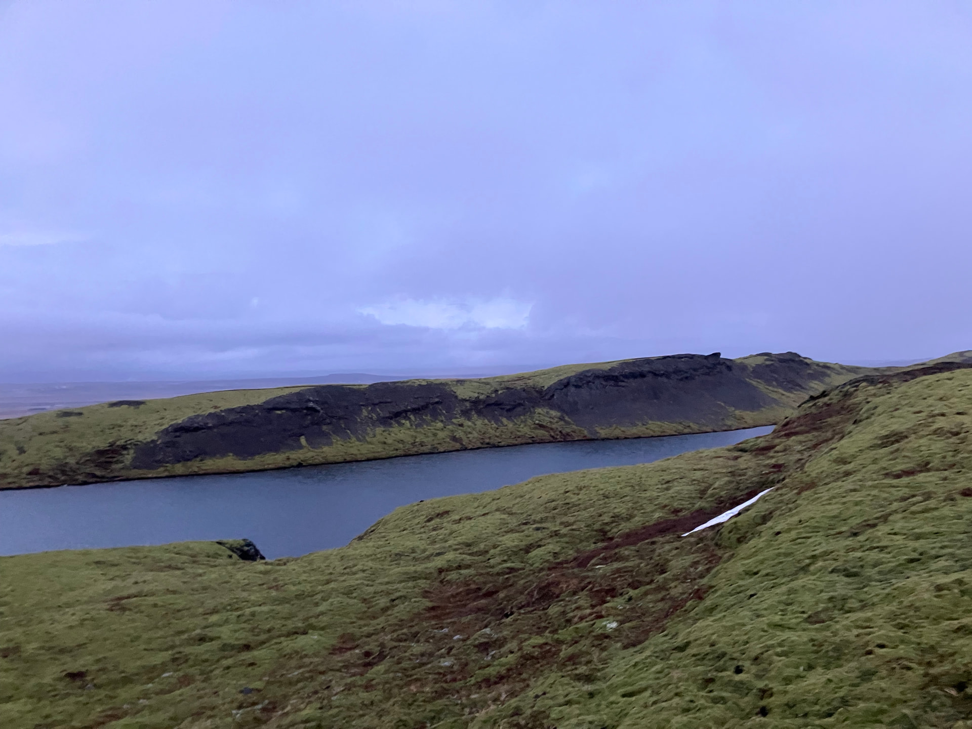
TF/SL-215 (Miðfell Skeiðum on Iceland) which is an extinct (dormant?) volcano with a lake in the crater. Not exactly in the activation zone, but close enough to take a swim before or after an activation. I did not attempt it, as the water was too cold for my taste and night was closing in when I activated the summit almost a year ago. Here’s the lake as seen from my operating position:
.pl has the most LLOTA references presently (iirc). No excuses!
.is and .cz don’t have country managers as yet so have no references added. They look like great locations though.
I’ve been learning a lot about water bodies across the EI landscape while doing this. Culminating in adding a new reference today which requires activating asap by someone! Behold!: