According to rule 3.5 text, … This Vertical Distance will define a contour outlining an Activation Zone, within which a Summit operation will be considered valid …
I think that the rule should be more clear by adding a precision: This Vertical Distance will define a contour outlining an Activation Zone and containing the summit, within which a Summit operation will be considered valid …
Reason: We have a case here that may case confusion: near a real summit, there is a slightly lower hill about 700 m away. That hill could be reached with a 60 m descent then going up to it. So, the 25 m vertical distance from the real summit generate a second closed contour line around the smaller hill (using GEarth flood process). In my opinion. the only valid activation zone for the (first) summit is the one that contains the real summit inside of it. So the second pseudo AZ could not produce a valid activation for the real summit. Opinion? Discussed before?
The summit activation zone is the area bounded by the -25 metre contour so in your example the subsidiary summit is not in the AZ and does not count. Your opinion is correct I would say.
I don’t understand why there is any confusion Pierre, if…
…which makes it very clear this is not within the 25-m AZ.
The activator should be confident he/she is working within the rules. Whatever is the accuracy of your data choose your activation position such that you are confident making the worst reasonable assumption. GE data are of unknown provenance and I wouldn’t rely on them much.
[I was actually discussing the Google elevation data with a Google guy a couple of months ago. He was using them for propagation prediction, but Google were reluctant even to give Google full access!]
In VE2 you have the CDEM data set publicly available. There’s a big overhead in learning how to use the data, so I’m happy to chip in and take a look at individual cases, and put results on summit pages. Tell me which one this is and I’ll do that.
By the definition of a SOTA summit the lower summit cannot be considered as either part of the main summit or a seperate SOTA summit, the col is too far below the true summit and the subsidiary summit has too little prominence.
The FAQ gives a little more detail:
" Q. What is the Activation Zone?
A. Often it is inconvenient to operate from the actual highest point of a summit, there may be structures there, or on a frequently visited summit there may be too many people about. The SOTA rules permit the operating position to be away from the summit but not more than 25 vertical metres below the summit. If you draw a contour line on a map 25 metres below the summit, the area within this contour is the Activation Zone. See this MT blog posting for more information. If you operate from outside the AZ, the activation is not valid and will score no points."
… Just read the mentioned MT blog about the AZ, and it is more precise: “So, this is our definition of the Activation Zone (AZ). Is there a contour all the way around the summit, no more than 25 m down the hill, that encloses your operating position?”
The mention ‘around the summit’ is not in the official rule … For any summit, drawing a horizontal plane 25 m below it maximum height could generate by intersection many contours lines all around … But the only valid one is of course the contour line around the summit, even if the rule don’t say that …
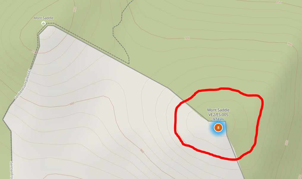
BTW, my example was for VE2/ES-005 (the real one) and the smaller hill is called Mont Saddle to the N-W. Another rule says that ‘Peaks separated by a shallow col should be considered as a single summit’. A bit vague IMO …Is the 700 m distance between the two a shallow col ?
The summit is at 974m, the AZ extends to 949m. The thick red line is just the lower side of the 950m contour on the map. There’s no way you could think the summit 700m NW is in the AZ for VE2/ES-005.
Quote: There’s no way you could think the summit 700m NW is in the AZ for VE2/ES-005.
However, if a summit “has two peaks separated by a shallow col” (rule 3.5.2) which is lower than 25m vertical form each peak, then 2 contour non overlapping or tangent curves may be generated in certain cases, one around each peak, so it would be a situation where 2 distincts and separated AZs exists for the same summit ?? Then an activation in either AZs would be OK. This was the situation I was thinking about. But the definition of a ‘shallow col’ is not clear, and it is not sure that this is the same summit in the case of VE2/ES-005…
The sentence you quoted is meant to explain the sentence before, which you did not quote:
Summits should be distinct peaks. This means that there must be a vertical separation of at least the association’s prominence value between summits and their associated cols (also known as saddles).
So this is about summits only being valid if they meet the prominence criterion for the association. A “shallow col” is any col which is insufficiently deep to meet this criterion. It is unrelated to the definition of the AZ.
There is always scope for improving the explanation of the prominence criterion and the AZ, as they are difficult concepts to express. But I don’t recall anybody arguing the meaning of the AZ this way before. When we talk about " a closed contour line at the permitted maximum Vertical Distance below the summit" we do mean the one that is below the summit in the sense that it is lower than the summit and encloses it, and only that one. Any contour line elsewhere is I suppose closed (unless you want to argue about vertical cliffs) but not closed in the sense that we mean - enclosing the summit.
So thank you Pierre, we’ll take that on-board for the next review. I hope you find the explanation and further guidance from the blog page satisfactory.
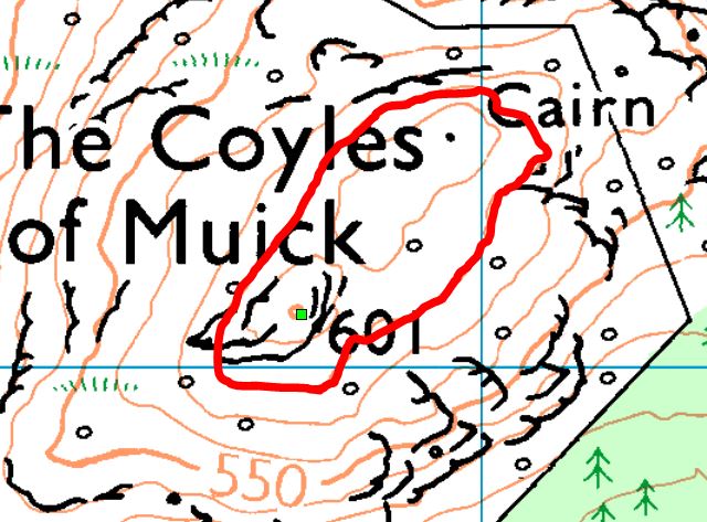
An example of a summit with two peaks that is a single summit. One peak is 601m the other is 596 ISTR. The drop between is less than 25m with the red highlighted contour the 580m level, the AZ being 576m but accurate enough as an example.
I think it would be good if the rules contained an accurate definition of the AZ. The “closed contour” description is in my view misleading, because it defines a condition which is necessary but not sufficient. It can fail if the ground in the vicinity of the summit is not convex. A closed contour 25m below the summit can contain within it points that are more than 25m below the summit and hence outside the AZ.
I don’t think an accurate definition is all that hard. As a computer scientist, I quite like recursive definitions, e.g.
A point on the natural ground surface is in the AZ if
a) it is the true summit, or
b) it is no lower than the maximum vertical distance below the true summit and adjacent to a point in the AZ
Obviously an equivalent non-recursive definition is possible if you don’t like that.
The point about the activation zone as defined by a contour is that it is just a convenient visualisation of the 25 metre rule. Yes there may be topographic depressions within that contour that are deep enough for the lower parts to be more than 25 metres below the summit, but since the AZ is only defined by that 25 metres and not by an invisible line on the ground then the lower part of the depression is by that definition not part of the AZ - although inside it is outside!
Yes, I like that. But I don’t think it is sufficiently obvious that we will never see another question about the AZ.
My own favourite explanation is that it’s any point you could reach from the summit without ever going more than 25m lower than the summit. But then I guess you get comments like “but there’s no footpath from here to the summit”.
Opinion:
So, about VE2/ES-005 to resume, I see a situation where there are 2 peaks and one summit… Reason: Because VE2SOTA is a P150 association, the max 60 m (approx) descent qualify the direct path between them as a ‘shallow col’. Then in that particular case, we can draw two non intersecting 25 m contours lines (one around each peak), but that doesn’t generate 2 distinct AZs if we agree to say that the only accepted AZ is the one containing the higher peak (hoping that they are not at exactly the same height !).
BTW, on geo maps, like the one posted earlier by MM0FMF, we see that the name ‘Saddle’ (appropriate name…) is given for the two peaks site (of course, I know that maps are not in SOTA criteria due to the various interpretations they have).
Hi Pierre.
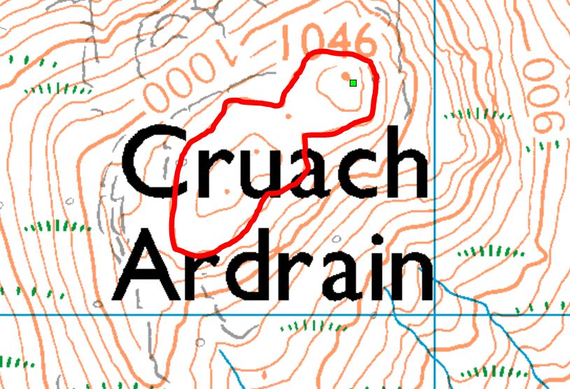
Since the summit in question is on the US border unfortunately I can’t easily draw an accurate contour with CDEM, as it covers only VE. But here is one made with SRTM, looking much like Andy’s above.
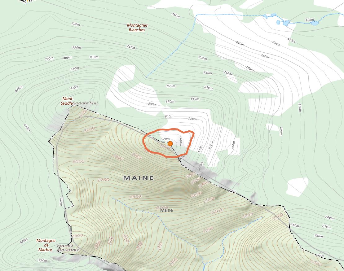
Coming down 25m defines the limit of the AZ. There is only one AZ, defined by this 25-m limit. Anywhere outside of that closed contour (closed around the summit) is outside of the AZ. Yes, there is another contour at the same elevation around the lower summit, ~830m WNW, but by then you have already left the AZ by descending more than 25m. Therefore operation from that lower summit is not valid for VE2/ES-005. You could find very many other contours at the same height; there are even some near me, 1000s of km away! They are all equally invalid for an activation of VE2/ES-005.
If the drop from the lower summit were at least 150m it (the lower summit) would count as a separate summit, with its own reference. But the drop is only about 51m.
Perhaps the name is indeed causing some confusion. The valid summit did in the past have a designation as W1/AM-100, named “Big Saddle Hill” (USGS marks the lower summit “Saddle Hill”, as you can see). If you’d like to make a change please let us know. Perhaps “Mont Saddle (Big Saddle Hill)”?
Thanks for the clarification Simon. I understand that SOTA consider the situation as two summits, but not as a single summit with two peaks. About W1/AM-100, since that summit was also in the earlier VE2 listing, and because a summit cannot belong to two associations, we agreed in 2017 with Tom N2YTF W1 RM to consider it only as a VE2 summit (The AZ area is larger on Canada side). It was then removed form the W1 listing.
Mont Saddle (Big Saddle Hill) could be a good choice for designation (actually Mont Saddle).