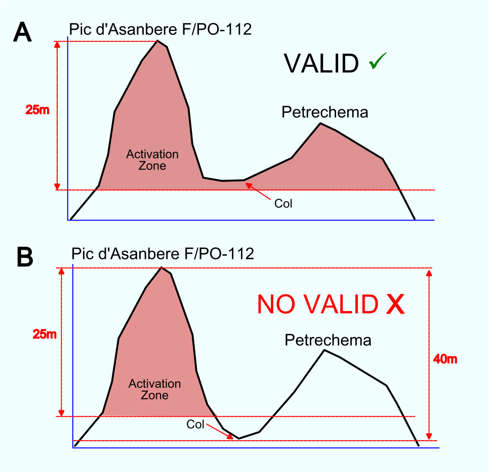
Seems that some activators don’t have the AZ definition clear enough already.
P.D.: Real case is B
73, Mikel
4 Likes
Hello Mikel,
This consider only the 25m hight… you should add the 150m distance away from trig point.?
Gerald F6HBI
1 Like
Hi Mikel,
I think you may not have considered the topographic prominence. For a summit to be valid, there must be at least a 150-meter drop from the higher summit.
Ciao, Claudio IK5VYZ
2 Likes
Hi Gerald,
I cannot find any rule amongst the 3.7.1 paragraph points of the General Rules v.1.21 about that 150m distance from the summit you mentioned, just the 25m vertical distance (part 4).
73, Mikel
5 Likes
No such rule.
MM0FMF
obo SOTA Management Group.
5 Likes
Hi Claudio
As long as the Pic d’Asanbere has a SOTA reference, it is supposed to have at least that prominence.
I am talking about a recent real case, where the activator has already declared that the activation was carried on from Petrechema summit, out of the F/PO-112 AZ. Actually, Asanbere had not been yet activated due to its high climbing difficulty, while Petrechema (not SOTA itself) is accesible just hiking.
73, Mikel
1 Like
so, what’s written in this post is just meant as general guidance? https://www.sota.org.uk/Blog/2017/06/19/Finding-Summits—Part-1
Hi Mikel,
ok, now the context is clear.
Thank
73, Claudio
1 Like
Hi Mikel,
I don’t know why, but i created this rule (150m) in my mind.
I discover now that some french summits in FL/NO or F/MC can be activated at more than 600m away from the summit. This is fine for some activators that are less-able than others.
Thanks Mikel, and see you from S2S.
Gerald F6HBI
4 Likes
You welcome, CU ON S2S!
73, Mikel
1 Like
This activation is claimed by @EA5ER
Have you contacted him or the Association Manager? I agree that the activation made from that subsidiary summit would not be valid.
2 Likes
I didn’t mention any call. Anyway, I believe that if it was necessary to contact anyone, that should be made by the MT or AM, not by me.
73, Mikel
2 Likes
The observation is that the chasers did not have the honesty to correct their log, leaves perplexed…
73’s Chris F4WBN
4 Likes
Thanks for the notice, Chris! BTW I forgot to delete the S2S QSO I did…
Fixed.
73, Mikel
1 Like
The observation is that the chasers did not have the honesty to correct their log, leaves perplexed…
Done
73 Fabio
2 Likes
To add, although the “activation zone” website is a good reference and a great tool, if you have any doubts, it’s best to check with updated official maps before heading out into the mountains. In the case of Spain, use IGN maps or other official sources. I’ve been able to find substantial differences of a few meters that may or may not give you the zone as valid. This isn’t the case, but in Mikel’s example, if there were a 26 or 27 meter difference at the double summit, I would check first using these more precise methods.
1 Like