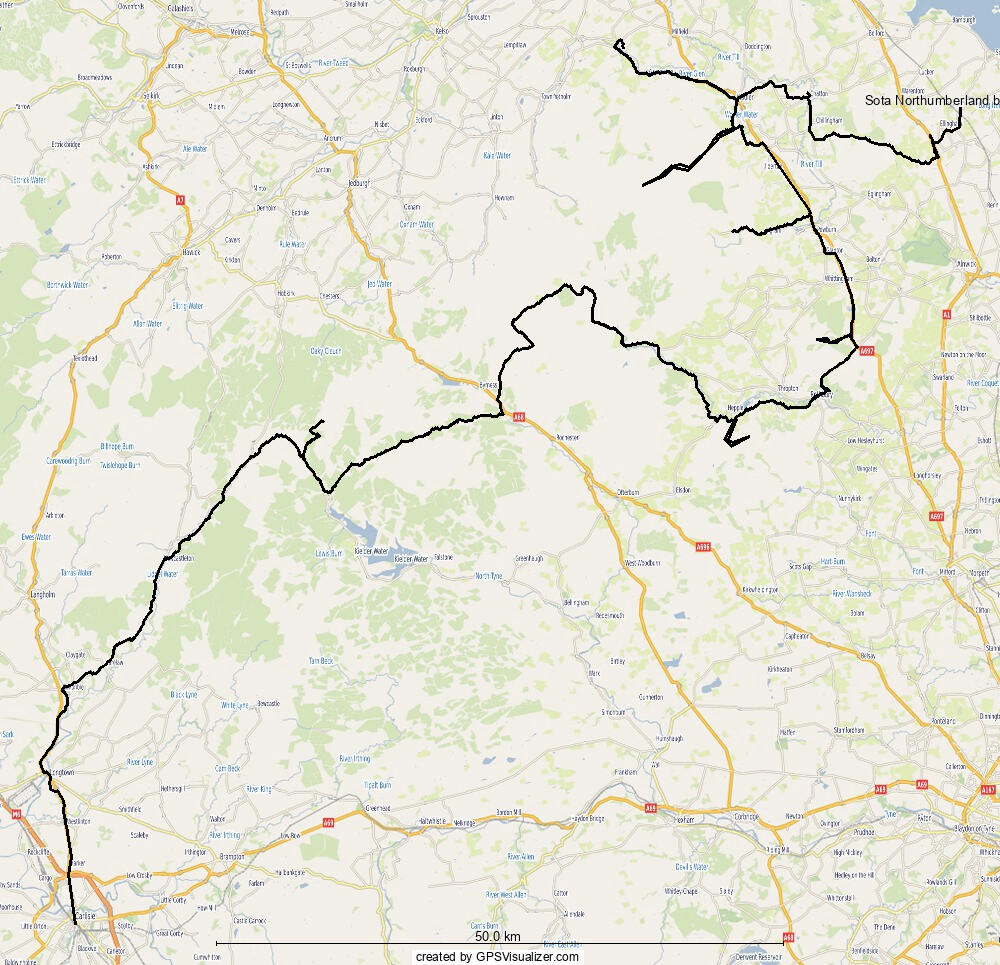
Since completing earlier in the year, I had been looking for a new challenge. Activating all of the SOTa summits in Northumberland as part of a cycle tour seemed like a good challenge. There are seven summits in Northumberland. Six of the summits are neatly arranged on the eastern side of the Northumberland National Park, the seventh (Peel Fell) is somewhat further to the west, making this an interesting challenge as a cycle tour. Indeed, as you’ll see, the route from eastern Northumberland to western Northumberland is a particular delight.
I started the tour on the afternoon of Thursday 17 July, travelling by rail to the little station of Chathill on the Northumberland coast. In a quirk of railway time-tabling, a direct service runs from Carlisle to Chathill via Hexham and Newcastle. This is a scenic 3 hour journey on a class 158. I was very glad to make the connection at Carlisle, as only two trains per day call at Chathill, one in the early morning and one at 1900hrs in the evening. I double that that many tickets are sold as a through journey from Carlisle to Chathill,.
Chathill is a lovely little station, first opened in March 184, but the service was scaled back to its current two trains (each way) in the early 1990s. Passenger numbers in 2023/4 were 1264,
So on average one person alights or boards each train.
In the run up to starting the tour I had noted the forecast for lightning late on Friday afternoon. During the journey I checked the forecast again and was disappointed to see the forecast lightning now started at 10am on Friday, and ran until Monday. I was not feeling optimistic about my prospects, but decided I would still make a good cycle tour even if I could not ascend any summits. I had originally planned to camp near the first summit of Ros Castle, but hatched a plan to ride into the evening and camp at the foot of The Cheviot, to allow an early morning activation before the lightning was forecast.
Alighting the train at 1900hrs, it was a bright evening with plenty of sun, and I set off westwards without delay, catching a few glimpses over my shoulder of the beautiful Northumberland coast. After a few kilometers of cycling across rolling country, I joined the dual carriageway of the A1 for a short stretch, reminiscing on previous cycle rides up and down this very road. I resumed my westward track, passing through a windfarm as the road rose up through heathland onto open moor.
The map showed dashed margins to the road, indicating an unfenced road, a good indicator of camping opportunities. This is where I had originally planned to spend the night but instead I continued a little further to the foot of Ros Castle (G/SB-009).
Ros Castle is a delightful hill, a rocky outcrop clad in heather, and only a 5 minute bimble to the top from the road. The outcrop is an Iron Age hillfort, and on its summit there is a stone built hodoscope that sort of looks like a castle.
I had parked my cycle by the road, and scampered quickly up the summit, conscious of still having a bit of cycling left that evening. I was pleased to find a bench at the summit. The trig point central hole was filled - so could not be used as an antenna support, but the bench would suffice.
I called out first on 2m, and first to respond was G0EVV, we had a chat about my plans for the weekend before I called CQ. There were no further callers so I quickly setup my EFHW and QMX radio for a CW activation. On 40m I worked S57S and then a contest station PA0RBA but no further station. A second call on 2m yielded 2E0CVT and 2E0RLT, giving me enough chasers to qualify.
I paused for a few minutes to munch some chocolate and survey the view before heading back down to my bicycle. It was a lovely, but still very warm, evening as I set off towards The Cheviot. The time was now after 2030 hrs as I gilded down the road past Chillingham Castle and some very pretty looking houses. I was looking for a house with an outside tap, to stock up on water, and soon found one. A quick tap on the door led to a pleasant conversation with the owner, and permission to use their tap and any other facilities I wanted.

A lovely evening for a cycle ride

Ros Castle

A comfortable activating position on summit of Ros Castle
Fully stocked with 3 litres of water (it sound a lot – but I realised the following morning there were no mountain streams to cross on The Cheviot, so was a good decision) I continued west crossing the A697 and joining the cycle route 68 along a minor road, only to find the road crossed by a ford. One of the reasons I never bother with cycle routes as they seem to follow the most perverse routes. Fortunately the ford was quite shallow and I walked across with my cycle. Leaving the silly route 68, I headed to the Harthope Valley, climbing a double chevron road, followed another single chevron, before descending to Harthrope Burn (the stream names don’t seem to have got the message about this being England rather than Scotland) at 2145, almost exactly sunset time.
With light now starting to fade in the deep sided valley I was scoping out possible camping spots – of which there are many. I eventually opted for a spot in some wooded land just off the road, and set about getting my tent pitched. By about 2230 I was properly installed in my tent, and having a quick snack before getting off to sleep.

Crossing a ford
I had a wonderfully restful night’s sleep, and woke at about 0515 to typical woodland sounds align with some sheep grazing near to the tent. I quickly got packed away, and cycled the short distance to the roadhead, before realising I needed to backtrack a few hundred metres to find the start of the bridleway ascending The Cheviot. At shortly after about 0600hrs I began my ascent. The early morning conditions provided great views back to the Northumberland Coast as I headed over the grassy moorland following a very clear path. I’ve not walked in the Cheviots before, so I was enjoying the new scenery.
The route provided no difficulty and I soon reached the summit, passing a couple of large cairns on the way. The last few hundred metres were over paving slabs, until the trigpoint (mounted on a large plinth) came into view. Given the effort to construct such a plinth. The mist had descended and it was very damp, I started to wonder why they couldn’t have designed the plinth to have a small “inside” area accessible through a low doorway.
Calling on 2m with my FT70D and a RH770 telescopic antenna gave no answer (kind of expected at this time), so I moved onto CW. I set up my telescopic pole and called CQ on 40m CW at 0730, not sure who would be around at this time on a Friday morning. S57S did not disappoint, and was loud and clear, followed by ON7ZM, SP1QJ D1HBT, DF1PV, N4FI and DF5WC. I made a few more calls on 2m, to no avail, and then decided to head back down to my cycle. As I was dismantling my antenna, the antenna wire on my EFHW snapped close to the 49:1 transformer. I had been getting occasional high SWR readings for the last few outings, so really should have taken a look at it. I could have easily fixed it by twisting the wire onto the terminal, but I was carrying a spare EFHW that I bought ready made from aliexpress as a backup, and looked forward to testing on the next summit.

Secluded woodland camp


Activating position

Back at the bike
Back on my bicycle it was now about 0900am, I had spent a good while sitting up on the summit and the day was already marching on. I retraced yesterday’s route up the valley, climbing the double chevrons again, before turning north to Wooler.
Wooler is a typical stone built North England market town, just the sort of place for a morning break. I paused to eat a sausage sandwich at a cafe, and stock up on other provisions. My next summit would require an out-and-back cycle ride from Wooler, so I knew I would return later.
I left Wooler at about 1100hrs, heading northwest along the B6351 a distance of about 15km to the next hill. The road was signposted to Kirt Yetholm , the terminus of the Pennine Way, and passed the historic settlement of Ad Gefrin. I stopped at Ad Gefrin to have a look around, and was pleased to have stumbled upon this historic location. The road eventually swung around to the base of Housedon Hill (G/SB-010), set in agricultural land (which always seems to mean a difficult ascent)
I set off from Reedsford following a footpath onto access land, before making a beeline for the summit over long grass and heather. The grassy summit has a fence running across, an idea for attaching a pole with a bungee, and this allowed me to quickly get my AliExpress EFHW setup.
My operating position, in the middle of the no-doubt tick infested grass, was inconvenient but I was very pleased to find the EFHW gave a low SWR on and called out on 40m, to hear OT5Q, followed by 20m to hear DL1DXA, SP8RHP, OM2ITO, OH3GZ and HB8ITO/P on HB/VS-102 followed by LA5FSN. As I was packing away I caught G4KWG/P on G/LD-010 (St Sunday Crag). I was especially pleased with this last QSO as I had not chased it before and now need to chase only 8 more LD summits to have both chased and activated them all.
I hung around on the summit, eating a couple of teacakes and admiring the view into Scotland, and the Eidon Hills clearly visible on the horizon. The descent was very quick, and I was back cycling by about 1400hrs, heading towards the A697 towards Wooler. I opted to take a different route back to Woller to avoid simply retracing my steps. A signpost to Flodden Field, tempted me to take a detour… it would have been an extra 12km and I decided against it, but perhaps will be back soon.

A bit of history on the cycle ride

Uncomfortable activating position

View from the summit
Back in Wooler I stocked up on supplies before rejoining the A697 to continue south about 15km to Powburn before turning westwards into the Breamish valley. The valley is a dead end, and gets me no closer to my next hill, but the map suggested there might be some good options to camp.
Sure enough, all along the valley are good options (for responsible campers) and I found a spot near the very western end of the valley. I hoped any other campers would have settled on a spot before venturing that far. As I was cycling along the valley a heavy downpour passed over. This was the only sign of the poor weather forecast I had seen today, so I couldn;t complain.
I set up my tent in a secluded spot, invisible from the road, and sat on the river bank watching the water go by. For dinner I had some sort of past dish; a military ration cooked using a flameless ration heater. This was accompanied by some lemon and scampi crisps and a cinnamon bun.
Back at home in Cumbria, I dislike seeing people camped for a weekend in popular spots such as this, but I think there is a difference between camping from evening to dawn in a single man tent, and car camping for weekend. The former is minimal impact and constrained by the limits of physical effort, the latter has become too easy and leads to inconsiderate camping and lighting of fires.
A restful night’s sleep was interrupted at about 0200hrs by thunder and lightning, impressive to watch through the doorway of my tent. I slept quite late and was not on the move until about 0900hrs, (so much for dusk to dawn camping!)
Heading out of the valley, I crossed a footbridge to avoid retracing my route, and eventually rejoined the A road, heading south. It was a wet but mild morning with little wind, and no longer a threat of lightning (based on the forecast). I soon reached Thrunton Wood where I parked my bicycle and headed into the forestry plantation to climb Long Crag (G/SB-008). I wasn’’t expecting much from this hill, being in a forestry area, but I was pleasantly surprised. Once off the main forest track, the route became a pleasant trod through heather and trees to reach the summit. A thick mist meant there were no views; indeed the white painted trig point was so well camouflaged in the mist that I almost ran into it.
It was now raining so I was hoping to qualify the hill on 2m only. I called out CQ at 1120hrs, and heard G6URP/M respond. He was driving along the A road I had just left, heading from Newcastle to Abredeen, so we had a quick chat for a bit. I then spoke with G0EVV (whom I had heard back on Ros Castle on Thursday evening). I was able to update him on my progress and listen to his ventures over the past day or so. I was then pleased to hear G1BBY and G3VUD in order to qualify for the hill.


Pleasant camp spot by the River Breamish

Cycling over the river Breamish

Bike parked for climb of Long Crag

Long Crag Summit
With the rain getting heavier, I didn;t hang around, and started the descent back to my bicycle. I was underway again at 1130BST, looking forward to getting some lunch in Rothbury. The route to Rothbury brought back memories of my first cycle tour 20 years ago. I headed across to Newcastle from West Cumbria, and then up to Northumberland before heading down to Haltwistle and back home. Back in those days, I did not believe in wearing waterproofs while cycling, and so had not brought a proper waterproof. The weather in Northumberland made me rethink my choices, and I dropped into a hardware store in Rothbury to buy something - but to no avail.

20 years ago - no front panniers, carbon fork and no waterproofs!

This time - still raining in Rothbury
By the time I reached Rothbury it was raining heavily, and I stopped at a Cafe for some lunch, and then stocked up on provision at the CoOp. I headed West out of Rothbury along Coquetdale, passing through Hepple before turning off the B6341 to the hamlet of Hepple Whitefield where I parked my bicycle to start the ascent of Tosson Hill (G/SB-007)
I dutifully followed the marked bridleway, which crossed a field of cows, but it would have been better to just follow the tarmac drive which joins the bridleway after a hundred metres. I parked my bicycle and changed into walking mode. It looked like it might be brightening up, but the rain was still failing.
The route crossed some pasture before heading onto grouse moorland, skirting around Whitefield Hill. This was a pleasant walk across some heather moorland despite the rain, although I was starting to get very wet. I was absolutely delighted to come across a well built stalkers hut (marked on 1:50k OS maps, but not on 1:25k), and even more pleased to find the door unlocked. I stepped inside to get some respite from the rain, and ate a snack of chocolate covered macaroons.
The part of the route followed a narrow patch through the heather, with occasional flagstones. I jogged along as quickly as possible in the rain that was getting really quite heavy. A last steep and rocky part got me onto the summit, and I found another white painted trip point, set within a shelter.
Rather than try and write in the rain (even my waterproof notebook has its limits) I set my FT5D to record, and simply ran the QSOs. This was a huge mistake. I did a quick test to see if the log function created a file - which it did. I then conducted the activation getting around 7 or 8 QSOs. Before leaving the summit, I listened back to the recording and all I could hear was noise. It appears that I was Tx/Tx on VFO-B, and the record function simply records VFO-A, so I had no record of my QSOs. To be frank, I have started to very much dislike the Ft5D, it always seems to let me down.
I called out on 2m asking for chasers to call me again due to an error with my logging. Fortunately, several called back, and then I got a S2S with G1OXH on Red Screes (G/D-017), so all was good again. I headed off the summit, and jogged back across the moorland to rest in the hut. I fiddled with my Ft5D but all I had was a recording of nothing from VFO-A, stupid thing!
I was surprised by Tosson Hill. Its just a one-pointer but took more effort and time than I had expected. This was due to messing around with finding the bridleway route at the start, followed by rest-stops in the hut. However, it is a lovely hill, with a great walk through the heather and a picturesque summit, well worth a visit.

The summit of Tosson Hill

Pretty hillside (at least it would be if you could see it)

Sheltering from the rain
Time was rolling-on as I cycled await from my parking spot, it was now about 1730
And my initial hopes of activating the next hill this evening had evaporated. The pouring rain did not make this an enticing idea either.
I followed the river Coquet up a minor road to Sharperton and then continued up the valley. On OS maps this route looks like a dead end; indeed, at 12 miles long it looks like a very long dead end. OS maps suggest the road terminates at the medieval village of Kemylpethe. However, what OS maps do not declare is a network of tarmac roads across the Otterburn MoD training area, and which are open to the public except during periods of military activity. Heading up the River Coquet was the start of a long held plan to cycle from Rothbury to Kielder avoiding any big roads (or indeed, public roads).
AS I cycled up the valley, the rain seemed to get harder and harder. I called into the pub at Alwinton to fill up on water. I was tempted by the nearby campsite at Clennell, but it looked like some good options lay up ahead. To the west of Alwinton the road passes through some access land, bordering the Otterburn danger area. I stopped cycling at the 227 spot height near to a place called Carnaby Banks, and looked across the River Coquet to steep river cliffs.
My chosen camp spot was out of sight of the road, and quite close to an (unlit) red light that signifies when liver firing is underway. Once the tent was pitched I dived inside and changed into dry clothing. I had left my cooking equipment on my panniers, so waited for the rain to abate for a short spell before quickly retrieving what I needed.

A rainy evening
I cooked inside my tent, which shows how bad the rain must have been. I never cook inside my tent due to the risk of destroying the tent very quickly. My meal was a five-bean cassoulet (re-hydrated) followed by hot cross buns.
It must have been about 2000hrs when I pitched my tent, and during the brief respite from rain at about 2100hrs I walked around outside to take some photos. The forecast for tomorrow (Sunday) suggested more rain.
Waking up in the morning I found a bright and dry day, which was most surprising. I got packed away quickly and continued my cycle up the valley. In the dry weather I put on wet items of clothing hoping they would dry as I cycled along.


As I rode up the valley I was frequently passed my military vehicles; many of these were ordinary cars in ordinary colours but featuring an antenna on the roof and some form of laser detector or transmitter on each face of the vehicle, they all looked very interesting. The road passes the southern face of Shillhope Law (G/SB-006), where I paused looking at an obvious route to the summit; however, I continued up the valley to Barrowburn where the route marked in Sotl.as begins. I changed into walking mode, and headed up the grassy slope. Despite being two-pointer (by virtue of being a smidgen over 500m), Shillhope Law was an easy climb, made even better by the unexpectedly fine weather. The summit was reached quickly, and turned out to be another white trig point set within a stone shelter.
A call on 2m yielded no calls, which was a little unexpected at 0900hrs on a Sunday. Later in the day I noticed my FT5D was set to C4FM mode. The screen on the Ft5D is almost impossible to read in daylight, and so I probably missed it. Another downvote for the FT5D, I much prefer the FT70D for SOTA.
I setup my EFWH and called CQ on 40m CW to hear EA3BV, the skip conditions seemed very odd and so I tried 20m I heard SP8MAP/P on SP/BZ-004 and IK6BAK/P on I/MC-067 followed by the dependable S57S and then DF4FQ, G0FVS and OE5CL. Once the calls subsided I tried again on 2m, but it was probably just Tx digital.


Activating Shillhope Law
On the way down the hill, with a good ‘phone signal I checked the Otterburn range website to confirm that the range roads were open today. Buoyed by the possibility of adventure over roads I had not previously passed, I sprang down the hill to my bicycle.
I changed into my cycling shorts by the roadside, being very quick about it, and then after munching on some maltloaf, and putting a packet of Jelly Babies in my pocket (as an emergency boost for the climb ahead) I set off.
The route up Coquet Dale was some of the loveliest cycling I have done for ages, it had the feeling of a remote part of Scotland and I passed the occasional homestead. The road follows closely the meanderings of the river and is only steep at one location where it departs from the river slightly.
As I neared the end of the public road I paused to let an oncoming military car past. The car stopped next to me and the occupants (all dressed in army gear, and appearing to be armed) chatted with me, saying they had passed me a couple of times as I made my way up the valley. The road now turned sharply to the left, and started a steep climb following the Roman road of Deere Street and entering the Otterburn range. The quality of the road surface improved markedly.


End of the public road

The MoD road continues, snaking up to 500m elevation

I was there

Great views

Back on public roads the A68
This is an area of rich history with Roman camps such as Chew Green and Medieval settlements. The road climbs up to about 500m and gives great views across the cheviots. Indeed, the summit adjacent to the road is 505m, suggesting its parent Marilyn summit must be The Cheviot. At Middle Golden Pot the road meets a junction and I turned westwards again. The Golden POts are shaped stones found alongside Deere street erected in the 9th to 15th centuries as waymarkers for the road.
The onward route was easy descent, and I reached the A68 at Cottonshopeburnfoot, feeling like I had taken a great shortcut. The A68 itself is a wonderful road to cycle, passing over Carter Bar to Scotland. After refilling my waterbottles at the campsite, I headed a hundred meters south before turning onto the forest drive to Kielder.
I was riding a road touring bicycle with 28mm tyres, not well suited to this sort of track. But I have used this route a few times before and except for a couple of kilometers at the Kielder end, it tends to be okay. The tarmac gave way to the forest track, nicely compacted and fairly smooth and I trundled along at a steady pace, it was now just after midday and felt very warm and humid.
After about 8km the track opens out at the viewing point of Blakehope Nick, where a wooden structure has been built. The structure would have been much more practical with a roof of some kind, but it does give some interesting views.
The next 8km were a little rougher, with some long stretches of large stone chippings that made things much slower on my bicycle. About a 1 to 2km from the end I suffered a puncture on my rear wheel, but it was just a simple puncture with no damage to the tyre or wheel.
Reaching tarmac again felt lovely and I rolled into the Kielder visitor area for a rest. I drank two bottles of fizzy orange bought from the bike shop, and then got on my way. I stopped briefly at the Kielder village store (poorly stocked) and bought two packs of Viscount biscuits and 3 litres of water.

Track surface is not too bad

Viewing point half way along the forest drive

Rest stop at Kielder
The road headed around a few kilometers to Deadwater, where the forest track towards Peel Fell (G/SB-004) starts. I headed up the track on my bicycle where after about 1km I got another puncture in my rear wheel. I think my rear tyre was getting a bit too worn. Fortunately I carry a spare tyre.
The weather was closing in, with cumulus clouds starting to build into cumulo-nimbus, and the forecast again showing lightning due for the afternoon. Time was marching on, it was well after 1500hrs, and heavy rain was due at 1600hrs. I decided to lay down my bicycle and continue on foot, with the puncture repair and tyre swap waiting until my return.
I decanted the Viscount biscuits and some cans of Fanta into my backpack, and set off up the forest track. The route meanders for a while, and Peel Fell never seems to get any closer. It was tempting to cut more directly across some felled woodland, but I knew that that would be a hugely tiresome route.
I eventually left the forest track at the Scotland border, and headed North East, following the border exactly, to climb up the fell side. A narrow trod passed through thick grass and heather. I monitored the lightning app on my ‘phone, checking for any detection of lightning further out westwards.
Despite the tough ground conditions, this is a lovely fell. The summit plateau felt wild and desolate, with some interesting rocky outcrops. As I reached the summit, heavy droplets of rain started to fall. I called CQ (being sure I was on analogue FM) and quick to respond was M0XUP followed by M0SKY. After a further couple of minutes calling I heard G0ORO. I paced around the summit area for a while, watching the brooding sky until MM0IVR/P called from the Lammermuir hills. At 1500BST I closed down and headed briskly down the hill, looking forward to fixing my puncture.

Following the border of Scotland up Peel Fell

View from Peel Fell

The Summit
Back at the bike I guzzled a litre of water and several Viscount biscuits before swapping my tyre and inner tube. I then wheeled the bicycle back to the road. It was now about 1745BST, and my choices were to camp at the campsite in Kielder, or continue along the road where I knew from previous occasions there were some likely camping spots along Liddel Water.

Leaving England and Northumberland having activated all hills in Northumberland
I chose to continue cycling and passed into Scotland and along the Liddel Water. I didn’t fancy the camping spots. They were too close to the road, and not as nice I recalled; I had passed by several times previously and noted them as options, but now that it came to it, I didn’t fancy the idea. I think partly, I also wanted to continue rolling and make a bit more distance.
I continued along the B road to Newcastleton, with the rain falling heavily when I arrived. The campsite in Newcastleton is advertised as a motorcaravan site (i.e. no tents), and so my plan was to camp in the Newcastleton Forest. I went up to the campsite to have a look, and it seemed lovely and quiet, complete with a little duck bond. A resident told me that they accept tents and so within a few minutes I had checked the price (some sites want £30 for a one man tent, but this was more reasonable at £15, gone are the days of a camping spot for a fiver) and paid.
After pitching the tent I went to the pub for half a pint of lemonade and a plate of fish and chips (very nice) and then retired to my tent. The lightning never materialised (again) and the following morning was sunny despite a wet forecast. I rode into Carlise the following morning eyeing-up some other summits to activate in the future.