Great work Fraser. Well done. We considered Carn Ealasaid as an option for yesterday or today. Seems I was fortunate that I instead chose elsewhere yesterday!!
1 Like
I really enjoyed hiking it one afternoon last summer. I chose it today because it was only a 25 minute drive and a simple 45 minute walk. Every minute counts when you need to be QRV at 0530z!
I did consider Craigendarroch GM/ES-078 at Ballater, which is even closer, but it is surrounded by larger hills. I still need that one for a point though!
I half expected you to appear on 20m for the chase.
2 Likes
Today was one of those frustrating ones here when work gets in the way of the hobby! Must sort out my priorities…… ![]()
1 Like
Question to the folks in the UK and or central Europe.
When the chasers states “I am beaming long path to VK”. What is the actual bearing of the yagi for long path propagation to VK.
When I am on a summit I want to know which direction the signal is arriving from.
Can someone in the UK or central Europe give me a beam heading please.
73 Andrew VK1AD
1 Like
Australia’s quite big… Assuming you mean VK1, from here, short path is beaming at 060 or therabouts, so long path is about 240. For VK6 it’d be nearer 090 and 270.
1 Like
Thanks Rick, so looking at the great circle map centered on VK1, UK long path signals will arrive in VK1 from ~140 degrees (south-east).
Signals from central Europe will arrive in VK1 from my East around 100 degrees.
Regards
Andrew VK1AD
1 Like
I made a 7 minute video of Thursdays VK summit to summit chasing endeavours from the summit of Craiglich GM/ES-068. Didn’t bother with the GoPro yesterday as the wx was so poor.

It seems to have raised a lot of discussion points about the antenna, which is such an old idea it’s probably been forgotten about.
2 Likes
Andrew,
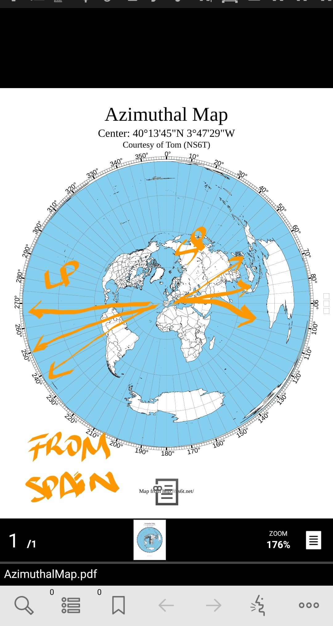
I suggest you go to NS6T's Azimuthal Map
Then enter the Latitude and Longitude you want to be at the map centre and set the distance, say 19,000 km. Print out your map and laminate it. It will be OK for all ACT and much of the surrounding VK2 summits if you put the centre of Canberra as the centre reference.
73
Ron
VK3AFW
Make a azimuthal map with any app or web on line, and you can see it. Long path pot Spain to Australia it’s by South America I think. Reverse mode from you crossing or beaming to South America.
Stupid question.
Is the only reason that we know it’s long path due to stations with directional beams reporting that, or is there another way?
1 Like
2 Likes
Normally time of day is a big hint. Australia is almost the antipode of the UK so long and short path distances are not vastly different. Of the order of 17000km vs 23000km.
2 Likes
Get your patents secured quickly, Fraser. A copy made here in the shack already this morning and currently under test…!
2 Likes
I’m thinking of making one for 10m next!
1 Like
Just shorten the top wire and radialpoise wire in situ by coiling up the excess 
1 Like
Hi Fraser,
Comparing signals vs heading with a beam is the simplest.
Ionospheric prediction service data should help.
Listening to the GPS synced International HF beacons should also help. If you an hear those in South America and NZ it’s long path to VK. If you can hear those to your ESE then it’s short path. Easier if you have a map of their locations.
If you can hear them all it’s a sunspot Maxima.
And for those in Spain wanting NZ it still matters which way you aim.
For the higher than 20 MHz frequencies the necessary ionisation follows the Sun so the daylight path will be best. Well mostly.
If you have the dedication you can set up a tx and a Rx station and measure the time delay. Of course the. NZ stations received in Spain are not going to produce much difference.
A loop with a sensing whip might work to get the direction.
73
Ron
VK3AFW
2 Likes
I did consider that, but the number of antennas needed for SOTA is n+1, where n=number of antennas.
3 Likes
I’m planning to be out again early Thursday morning (details later) - so just be warned that propagation conditions will unexpectedly tank on Thursday morning!
73 Ed.
3 Likes
Thanks Ron. That’s a detailed and useful description. I hadn’t really considered beacons.
As someone who only really operates portable from mountain tops, and when the activation is generally often only a small part of a bigger expedition, I often forget about the finer points of HF propogation. I think I’ll laminate a sheet with some beacon frequencies on it. It could come in handy.
73,
Fraser MM0EFI
1 Like