Are you actually using the range page when you see/hide these areas?
Rob – I really appreciate all the functionality of the mapping pages. I’m just getting back into SOTA, and I’m using the mapping page a lot. I’m amazed at what the volunteer effort has produced; it’s impressive by any measure. de K7ZOO
1 Like
No, just a simple view of Southern Scotland Rob.
The different region views such as nearby regions are really useful when you are looking at somewhere new to visit. But I was figuring out the best order to tackle a few GM/SS summits and didn’t need it. I haven’t noticed anything else misbehaving with region views.
Well… this particular topic presents a report on recent developments in the SMP range page, so I was assuming the problems you had been experienced were the results of my having made the alterations to that page as mentioned above. Which was perplexing, since I couldn’t reproduce such errors in that page.
Can I now assume that this was not the case, and that the problems you report are to be found in another of the SMP pages? The main page, perhaps?
Details, please: you help me, then hopefully I can help you.
Rob
Curt,
Thanks for the flowers - you’re welcome!
Rob
Rob thanks for the Polygon feature could it be used to define new summits that may have been missed by the mapping team. [Wayne and Me]
We have just a few such"possible" summits to prove one way or other in vk5 .
cheers
Ian vk5cz …
I don’t whether it’s a new issue or not Rob. I went to play with the range changes and the range polygon feature is a fine addition. I was able to define an irregular polygon around a set of roads in area I’ll be in a few weeks and it turned up loads of possibilities. It’s much easier than selecting regions by hand etc. or even multi region selections. It was after that I noticed the regions problem back on the main screen. You’ll know whether that is something that may have been introduced with these changes or not.
So main mapping page, select an assoc and region. By default you get the summit markers for the selected region, the region border (and shading) for the selected region, the region tooltip and the nearby regions shaded. From the layers icon dropdown, turn off region borders, region borders tooltips and nearby group borders. They all turn off and you see the map and the summit makers. Drag the map with the mouse and the region border and shading returns. Or you can alter the zoom and it returns. The layers icon dropdown is still open, so click region borders to turn it on (tick appears) and again to turn it off. The region border and shading disappears. As soon as you zoom or move, the region borders and shading comes back. It doesn’t matter whether the layers icon is open or closed.
As I said, I haven’t seen it before so maybe it was like this before these changes.
A good use of the polygon option in the range page, and one which I had not considered. Of course, when one is coding, the emphasis is on getting something to work - how it’s actually used is mostly down to the user.[quote=“MM0FMF, post:10, topic:14534”]
As soon as you zoom or move, the region borders and shading comes back. It doesn’t matter whether the layers icon is open or closed.
[/quote]
Yes, I thought I’d fixed all that a while ago, but as you say there was still a bug crawling around in the walls. Zapped it now, and in the process also discovered that the event-handler governing the visibility of the regions layer(s) boxes had been firing FIVE times at each zoom, pan, etc., so fixed that too.
So, it should be OK now,
This feature will only find those SOTA-registered summits which can fit inside a polygon on the map - it can’t identify any other summits. Of course, the local AM and associates could use it to identify hilly/mountainous areas within a polygon (state/county/park border?), but it would be up to them to properly research and identify any new summits for possible inclusion into the SOTA scheme.
So, no: it can’t perform the necessary research and identification work for you.
Rob
It’s a great addition. When you select multiple assocs/regions to look at somewhere new, you can end up with lots and lots of summits. That’s not an issue on this PC ( 4x i7 cores 8GB mem) or my home PC (8x i7 cores 8GB) but on my little travel PC (4x Atom 2GB mem) having lots of summits really slows down the display. That’s what you expect, a lower performance machine runs slower with lots of data to handle. With the polygon region, you can define a region that spans multiple assocs/regions but does not include all of them. The result is fewer summits and a much faster display on the travel PC.
It is. It is also noticeably faster when the various layers are selected as well.
Still using a 10-year old PC here (Win10) which has so little memory it’s a joke (or an 8-year old laptop with similar issues) - saving my pennies for a much better machine, but it’ll probably be summer/autumn this year before I can afford that.
To cap it all, the narrow-band internet access (600kB/sec download when I’m lucky) here just adds to the fun. NOT. Could be worse, though, mustn’t complain…
Another update to the range page in the SMP.
It is now possible to define a road route - around which SOTA summits should be found - in one of two ways:
-
“Use Google Directions Service” - this is the original road-route option which allows the user to define a route by entering start- and end-points, plus optional waypoints, and the program will attempt to find one or more routes using the Google Directions Service internally. This option will already be familiar to some of you.
-
“Define road route by choosing points from map”
 - this second, new, method to define a road route uses the mouse to mark multiple points in the map, thereby creating a “route” on the map, along which SOTA summits may then be found. The point-markers can at any time be dragged to a new place; controls are provided for editing or deleting the markers or route. The route so defined does not actually need to follow a road or roads - it could follow any feature on the map: a border between two countries, for instance. Your route might also follow a series of roads which the Google Directions Service will not, or cannot, offer as suggestions for a road route - the picturesque Blue Ridge Parkway in the US being a perfect example.
Hopefully, this new option may prove to be of use to somebody out there…
Rob
3 Likes
Hi Rob
This will be very useful!
I will “publicize” this tool in the Portuguese SOTA Channels (site and FB) because its a great tool
Thank you!
Vy 73
Rob, looks like this bug or a derivative of this bug has returned.
- Select main mapping page
- select an association (ea8)
- Select region, ea8/la
- Select layers dropdown, turn off region borders, region borders tooltips, nearby group borders and close dropdown.
Onlthe summit markers are shown overlaying the map.
5 Select new region, say ea8/go. The page updates, the summit markers overlay the map but the region border is also drawn. If you click layers dropdown the region borders checkbox is definitely not selected.
You can get rid of the region border by selecting it in the dropdown and then deselecting it. When you deselect it then it is erased from the map.
Yes, I’ve recently (half-) noticed this as a side-issue while working to get the updated version of the SMP ready, and wondered what might have broken what I had fixed earlier. But I hadn’t given it any real notice, or looked into it in any detail - it does need fixing, so I’ll get round to it tomorrow. At the moment I’m laid up with a bad back.
1 Like
OK, sorry for the delay - I’ve now refactored the “Layers” map control, and did away with the main page settings dialog area which also played some part in controlling the various regions layers.
So, the “Layers” map control now governs all aspects of regions layers presentation, and also sets and reads cookies depending on user interaction with the control. This probably looks like just a small cosmetic change, but in the background a lot has changed. It’s been a bit tricky to coordinate the complex interactions between various parts of the code, so I may have missed one or two snippets - I’m sure the users will let me know what is missing.
Before the change:

and after the change:
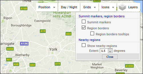
I’ve also cleaned up the way each of the map controls with dropdowns (i.e. the “Position”, “Grids”, “Icons” and “Layers” controls) interact with each other - if any one of the dropdowns is activated, any other visible dropdown will disappear.
UPDATE: user-settings for summit icon type and display of summit code labels (in the “Icons” map control) also now stored to cookies.
HTH, Rob
2 Likes
A thousand apologies Rob. I tested this as soon as you posted a fix was in place but forgot to say so. It fixed the issue I was seeing but I didn’t thrash it to see if there were any other issues. However, the reported problem is fixed and things work just peachy when I switch between regions.
Okey dokey, good to hear.
Another update to the Range page - the page can now be called or opened with pre-selected values. This is in (a somewhat belated) response to a request for such functionality from a SMP user.
So, for instance, the page can be opened to show any summits found within either a closed circle, or a ring/annulus, around a predefined reference point. Available types of reference point in this particular context are:
- Address/City/Feature
- Latitude+Longitude (decimal values only)
- Locator (Grid)
- SOTA Summit
Refer to the SMP overview page https://www.sotamaps.org/overview.php and scroll to the “Range Mapping Page” / “Opening the page with pre-selected values” subsection for more information on how this can be done.
Rob
3 Likes
Hi Rob
Very very useful feature.
Well done, as usual!
73 de Pedro, CT1DBS