Refractive enhancement is there all the time. Think of it optically, a ray of light passes into a less dense medium and is bent, refracted. A fish in a pond is not actually where you see it, it is closer to you, because the light leaving the pond is bent. In the case of a radio wave traveling horizontally from your antenna, because of the curvature of the Earth it will get progressively further from the ground. However as it progresses it encounters less and less dense air and will be progressively refracted downwards. In atmosphere the path of your signal is always a curve, independently of whether irregularities or ducts are encountered. “Line of sight” therefore is not a straight line. How much it deviates from a straight line is controlled by the state of the atmosphere at the time, but it will always deviate.
Under normal conditions, radio wave LOS is around 4/3rd optical LOS. After that you are into the troposcatter world that doesn’t exist every day and needs massive powers. ![]()
I look forward to someone explaining how I could hear the 2m beacon GB3VHF (Wrotham Kent JO01EH) at my old QTH of IO83KJ 365 days a year. That’s a distance of around 325km and well beyond the optical horizon or optical horizon *4/3 whilst it was running about 15W into a 3 ele Yagi and I used a 13ele Yagi into a 2.5db NF receiver. I’d suggest the normal day to day incoherent scatter in the common volume of troposhere both of our antennas could see. But that doesn’t exist.
Radio LOS also varies by latitude, as the height to the tropopause varies from 12 miles at the equator to 4 miles at the poles.
You know, I’ve wondered about that sort of thing, too. At my old QTH in SW Birmingham I could hear the Cornish beacon nearly every day, (and the Scottish beacon most days from here,) at that time in SW B’ham I was running an 8/8 slot fed antenna. It was a good QTH, but not that good! Of course the path to the Cornish beacon was partially over the sea which probably helped, but the Scottish beacon path is entirely over land.
Yes, I used to monitor the Angus beacon from here in Shrewsbury, almost always detectable and often good copy. 4ele yagi 5m agl, Ft290 Mk1, no pre-amp.
In this part of the world there are numerous beacons, repeaters, and amateurs within a few hundreds of kilometres, so maybe it is easier for us to observe these effects.
Me, i just climb hills and try to make contacts. Yes, it’s a scientific hobby, but on a mountain there are so many other factors that can break the science.
The best thing about using 2m on mountain tops (for me) is always expecting the worst and often being surprised how far 5w from the handheld gets me on occasion, either over an improbable path or over great distances. The HT is generally always enhanced by an improved antenna, usually half-wave flowerpot on my rucksack or a yagi.
A yagi wins every time - even handheld 1m up, and never more than 2m up a pole, in my experience.
Oh, and tropo defo. works for qrp. Climbing Lochnager in NE Scotland last winter, my ft-3d handie started going nuts picking up APRS beacons from Denmark, Norway, Belgium, so I knew there was a lift on. I hooked the same radio up to my 4 element yagi at the summit and worked ground stations in Wales, England all using 5 watts. 300+ miles away.
The initial question : height of a 2 Meter antenna.
The individual used : THE TAKE OFF ANGLE ,
The TAKE OFF ANGLE is used when the IONOSPHERE
reflects signals.
Signals on TWO METERS do NOT get reflected by the IONOSPHERE
You may deny that fact but you would be incorrect in doing so.
TWO METER signals are PROPAGATED by several discrete forms of PROPAGATION
- AURORA
- TROPOSPHERIC propagation
3 Line of SIGHT
Tropospheric occurs when a temperature inversion takes place. As you ascend from the Earth the temperature decreases about 1 degree for each 1,000 feet. In the Spring and Summer weather fronts do occasionally confront a cold and warm front. It the WARM front goes over the top of the colder front you have an inversion. When a VHF 2 meter signal crosses from a colder to a warmer front the signal is bent. That creates a DUCTING of the signal. That does occur. It is infrequent but it does occur.
The initial question used TAKE OFF angles in an analysis. That analytical tool is inappropriate to the question posed : the height of a Two Meter antenna
everyone can voice a response but this has now become so far from the reality that we are misleading people. TAKE OFF ANGLE analysis applies to HF signals which are propagated by F1 and F2 layers of the Ionosphere. A higher layer where Two Meter signals penetrate and are not reflected.
Silly how people chime in with irrelevant comments. I am not the brightest person but I do known something about Propagation. I have been on the air 70 years and on VHF for 50 years.
I leave you to your wits who to believe.
W9VNE
Hello James
I am with you in many ways!
Your consideration in your first execution I read in relation to a vertical antenna in the plane (without obstacles) , related to the classical propagation (LOS).
Then it came as so often in the threads to the : yes baer!
And the yes but! plays a decisive role particularly with SOTA now times.
With SOTA we are on the mountain and have with it (if it is not flattened above) a completely different radiation development. There the normal parameters against ground are often not valid any more, because the ground drops already a few wavelengths after the antenna… and often you can even select the summit afterwards.
I have no idea how the 2m propagation is with you. In Central Europe we have all possible effects… and that very often… and I don’t want to go into detail now.
As I said: Generally I find your explanations interesting… only for SOTA not so applicable.
73 Armin
I refrain from being critical
I strive to be accurate
If people want to believe rubbish they can
I attempt to be credible.
I am now closing down my comments
A waste of time
W9VNE
Take off angle is significant because if it is too high it reduces the signal in the wanted direction, which because of refraction needs to be a small angle above the horizontal. In pre-modeling days (like you I have been around for a looong time!) we had a rule of thumb that you needed to get your strongest output at about plus 5 degrees. However, I agree with Armin, we are over-analysing because we cannot compensate for the unique conditions of each summit.
take off angle only applies to HF as there there is a reflection
In Ionosphere VHF signals are not reflected they pass through to the cosmos
people are mixing terminology
there is bending in the Troposphere near the Earth
James,
This is becoming personal. The individual has a name. I am called Kevin.
I have no desire to provoke you or argue with you. When I used the expression ‘Take off angle’ I was referring to the angle of radiation from the antenna on the path to the receiving station. I was not implying that 2m FM signal are reflected from the ionosphere. I did not choose this expression specifically to antagonise you.
Please show some respect. By making this post I have asked for peer review which I welcome. I did not invite personal criticism.
You certainly are entitled to say what you feel
Enjoy yourself
W9VNE
No, sorry, take-off angle is the required angle to propagate the signal from the transmitting antenna toward the receiving one.
- Yes, on HF that usually implies firing the signal towards the ionosphere, from vertically upward (NVIS) to near horizontal (DX)
- On VHF, regardless of mode of propagation the angle will be fairly close to the horizontal. From a summit it may even be negative (when the receiver is actually below the transmitter)
Rick
I used a N9TAX (Rollup-Jpole) and to a lesser extent Arrow 3 element Yagi coupled to a FT60R/FT818 for my first 1000 points.
N9TAX farthest confirmed QSO 137 miles Colorado Front range-North of Cheyenne WY.
Arrow Yagi farthest confirmed QSO, Mt Marcy 236 miles into Queens NYC area the other ham was like NO WAY! 
I enjoyed the All VHF activating phase of my SOTA journey. Getting 1-2 QSOs in a remote area is pretty easy but 4 may require a lot of CQing! I came up short <4 or no QSOs about a dozen times but steep mountains with a high takeoff angle in my experience are the best (2m VHF)
73
Erik
Think SOTA folks have tropo scatter problems? Consider this:
"The Easternmost of three sites in the DEW DROP network, the Cape Dyer station was equipped with twin AN/FRC-101 parabolic antennae standing 90ft tall and transmitted at 100kw of power to reach its counterpart at Pingarssuit Mountain (“P Mountain) 693 miles away. At the time of its completion, the shot between Cape Dyer and P Mountain was the longest troposcatter shot in existence.”
And this is microwave, folks! I used the Cape Dyer antennas as a jumping off point to go across the Davis Straight to Sondrestrom AFB in Greenland, in 1985. First thing I saw was those antennas!
Have a peek: https://mapio.net/pic/p-13177793/
Best, Ken
Contrary to what has been said 2 m is reflected off the ionosphere. Aurora and E layer contacts are not everyday occurances but many of us have enjoyed these modes. When portable I have sometimes been able to work 1400 km on 2 m via the E layer and with the aid of a near 0 take off angle. I was on a sharp ridge
No on else worked these dx stations.
From home I have worked 2500 km of the E layer on 2 m.
None of this is unique. Stations in Europe work great distances via the ionosphere and report these contacts in a magazine called DUBUS.
Have fun out there.
73
Ron
VK3AFW
There is one thing I don t understand. This is your diagram from initial post.
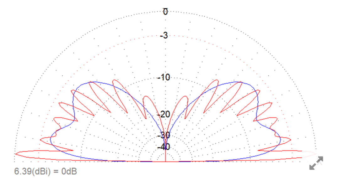
It is showing us upper right and upper left quadrant. What about lower right and lower left quadrant? Can you moddel it?
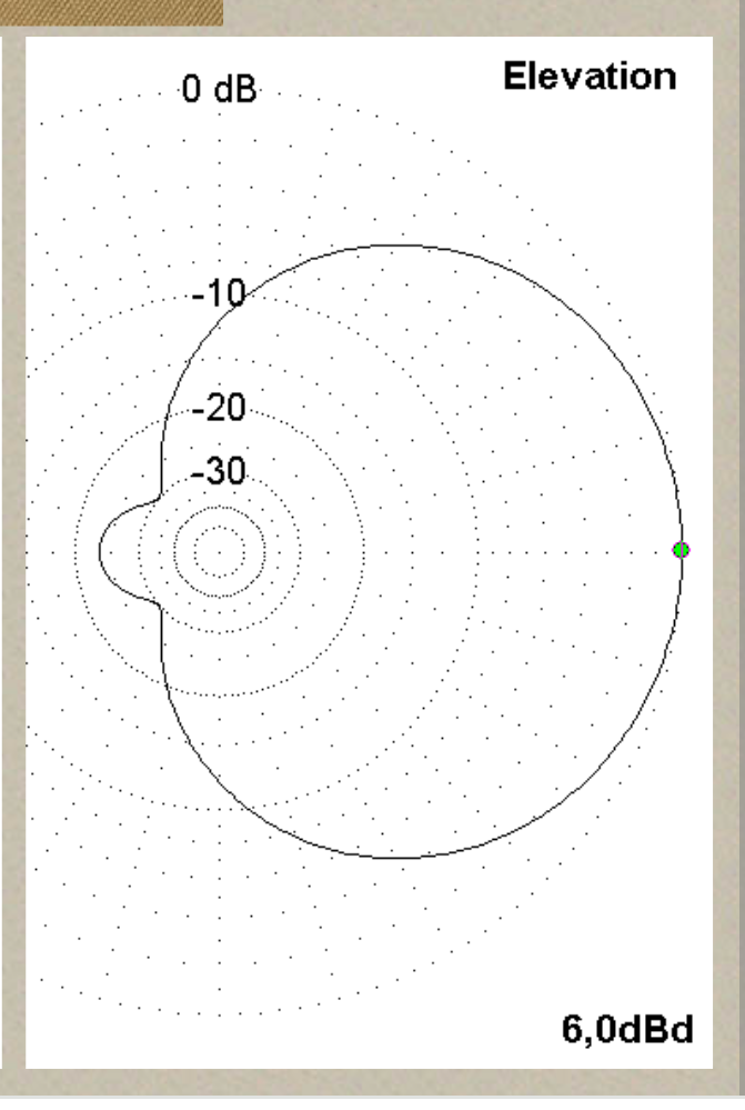
It would be interesting to see 360 degrees of vertical diagram. Here is the example of yagi antenna
After a little bit of thinking I came to conclusion. Maybe I am wrong.
Lower right and lower left quadrants are mirror picture of upper quadrants. So, energy radiated into the sky is wasted. For qso, on the summit, the lower lobes are important.
Correct me if I am wrong
A great question. The elevation plot is presenting the gain (dBi) in relation to the ground. The x-axis on the plot represents the ground. Most of the radiation directed at the ground is reflected, contributing to the the gain shown above ground in the plot. This is why ground conditions are so important.
The elevation pattern that you presented as an example of a Yagi is a model of an antenna in free space.
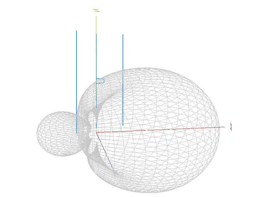
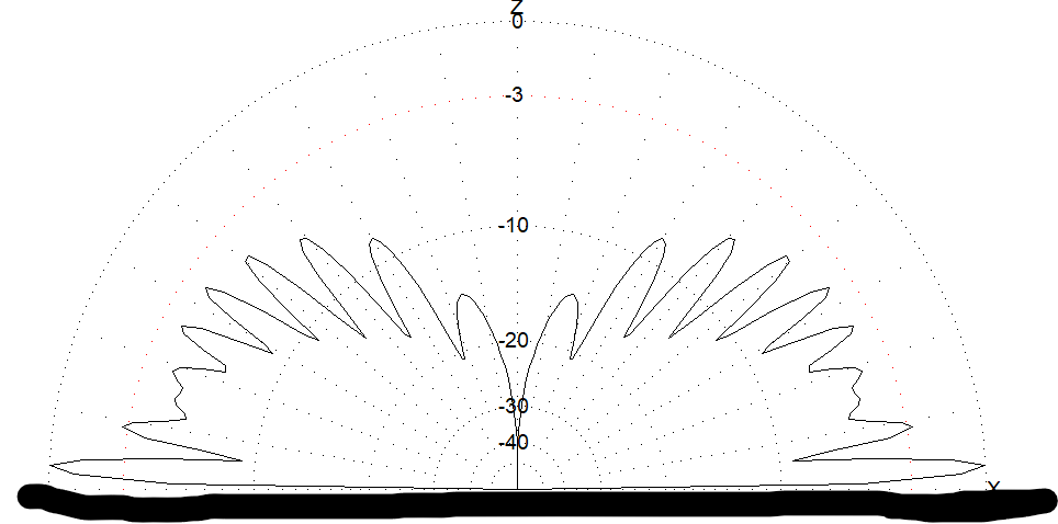
If we model this same Yagi antenna half a wavelength above an arbitary set of ‘typical’ ground conditions the far field plot looks very different.
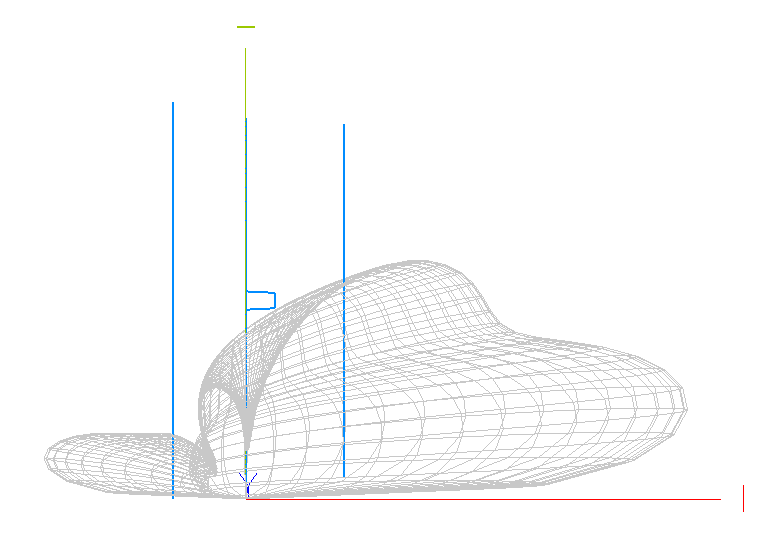
Repeating the model with the same Yagi antenna lifted to 4 1/2 wavelengths above the ground shows the emergence of lobes and an increase in low angle gain.
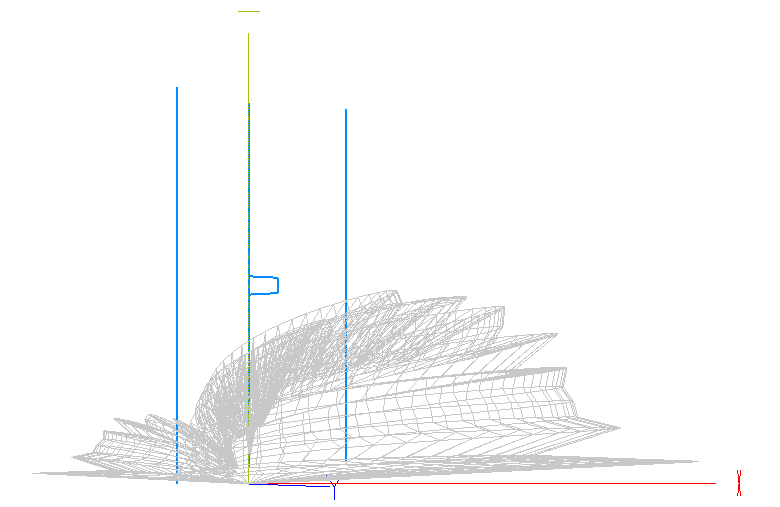
Modelling allows us to visualise the gain of an antenna by making some assumptions. Your plot used the assumption that the antenna is in ‘free space’. Modelling the antenna above ground uses a different set of assumptions, but does not bring the antenna into the real world, we now have assumptions of a level, flat ground with specific ground conditions. As has been pointed out summits are not flat, and the soil conditions, water table and countless other parameters are different from the idealised world that I am able to model. The visualisations are an aid our understanding but only take us so far.
I have some hunches on what might happen if the ground is not flat and level. If the ground is perfectly flat but inclined I think that the entire far field plot will be inclined. If the antenna is on an area of land that is inclined in an otherwise level landscape I suspect that the far field plot will be inclined to a lesser extend that the angle of the ground. If the antenna is sat on top of a cone of ground I suspect that the far filed plot will be pulled down towards the ground in all directions. This leads me to believe that it may be possible to place an antenna too high.
The real world is complex, and SOTA summits doubly complex. I will never be able to create a model for a real summit, let alone all summits.
I have assumed that I want to maximimse the RF at an angle near the horizon. What goes on once the RF leaves the antenna is even more unpredictable and may proove this assumption to be wrong in certain conditions.
I was on [SOTLAS](https://GW/SW-035 Myarth) yesterday, on 145.450mhz fm. This is a difficult summit for VHF. A helicopter flew over and suddenly I could hear @M1AJF on [SOTLAS](https://G/SC-006, Periton Hill) in a QSO with MW0SAW on my frequency. The helicopter left and they were gone, a great pity as I was struggling for a 4th contact. It would be easy to attribute this to a reflection from the helicopter, but who knows.
SOTA is about far more than antenna modelling, or even the perfect antenna. One of my ambitions is to have a summit to summit with Fraser one day.
I have watched your videos and you do far more than ‘just climb hills and try to make contacts’.
Yesterday I had a summit to summit with Gerald MM0EFI, who I had met on Mickle Fell earlier in the year. @M5RJC walked up a hill specifically for a summit to summit with me. There were lots of other people who made my day so pleasant that I have not mentioned.
The antenna helps, but untimately, for me, its about people.