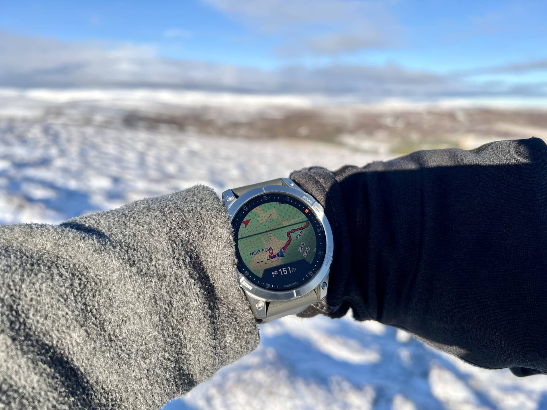
I have very much enjoyed my Garmin Epix watch that I picked up in the sale over Christmas.
It has GPS, you can load custom maps, add routes from your phone or computer and then follow along whilst it tracks your movements. It is so convenient looking at a map on your watch to check which way to go.
Yes, people ask me how my new TV is, but I don’t care as the lovely colour map that I can zoom and pan etc. with buttons (for that glove conversation) is ideal.
It acts as my 3rd device - watch, phone, and Garmin Inreach device (for emergency mostly) and of course a tiny Harvey’s ultramap in a pocket somewhere.
I think it’s a good idea to have some redundancy. I generally don’t carry paper maps any more.
I do carry my android phone with OS 1:25,000 + power bank.
I also carry a garmin inreach gps 66i.
My watch has a compass.
I carry an actual compass.
Me too – but only up to a point. The key word is “some”.
I carry a real compass (as well as a compass app on my phone). It’s just always there taking almost zero space & weight in my emergency & contingency bag (along with whistle, spare boot lace, rubber band, spare battery, etc) in my rucksack.
I’ve used a compass with (OS) paper maps since I was a Boy Scout and until a few decades ago. I’m not sure how one would use a stand-alone compass with a digital map on a phone, smartwatch or GPS device. For example, you can’t lay it on an electronic device’s screen as one can with a physical map to align with features or grid squares.
So, I think there are two non-exclusive navigational methods: 1) traditional paper map and compass or 2) GPS device with built-in map or paper map. In short, I think carrying a compass makes sense only if you use it with a paper map. But, if you think otherwise ….
Dave - that’s a very good point. Why indeed do I think I need one? I suppose I don’t altogether trust my mobile phone although I do run OS maps on it and it works very well. Of course I always have a paper map and Silva compass as a back up. At the back of my mind is that I can’t use the touch screen in the wet or when wearing gloves. I would like to be able to record a route and download the GPX file and be able to create a route and upload it to the GPS.
My Garmin also now resides in a drawer and hasn’t been on a SOTA trip for ages. The phone does a great job and has a big screen that I don’t need to squint at. There is always a powerbank in the pack in case it needs a charge. As a backup, I also have a lower end Garmin watch, a Forerunner 255. While it doesn’t have maps without a hack, I’ve used it to find my way back to the car during a balloon hunt in dense bush. In this case, I had to cross a river at a point where there was a log over it, and was able to retrace the route on the watch to find the log after a mild panic.
Glenn VK3YY.
Hello sota friends,
I am F6HBI for 16 years i use 2 or 3 different applications on my GSM.
One can show and save the track that i upload on Sota-Mapping (more than 900 for now).
The other one can show opentopomap with all Sota summits on it. These are imported from Sotl.as.
May be you can try the free app Organic Maps and import Summits.
Gerald
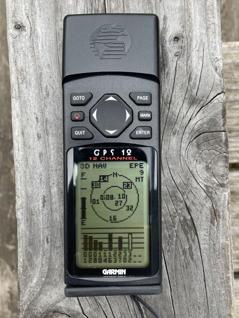
If you genuinely want a stand-alone GPS, we find the Garmin CSX range the most reliable of the ones we use. The touch-screen Garmins are even more useless than a capacitive-screen cellphone in the rain. And the Rino range is almost-unusably buggy. The CSX range appears to be more or less bulletproof and uses buttons rather than touch-screen, which are far more reliable in poor weather (though a pain if you want to type in custom waypoint names).
I wouldn’t use one for navigation (or only as a backup for navigation) due to the awful Garmin maps (compared to a genuine OS / LINZ / whatever topo50 map on an android device) and the small screen size. But they are ideal for track-logging and creating waypoints in all weathers.
If you want something touchscreen and genuinely all-weather you need to look for something with a cross-capacitive touchscreen (rather than capacitive as 99.9% of phones are). The only such devices I’ve come across are the android data-loggers used by couriers, in/out goods, field workers, etc (which also work as phones). We use very old Zebra TC-75X for this which are pretty cheap second hand (make sure you get the Google-play version, not the locked-down version), but there must be more recent models/devices out there. Cross-capacitive touch screens look for a connection between your hand holding the back of the device and a finger / pointer on the touchscreen, and so are unaffected by rain unless completely submerged.
Another vote for the redundancy approach my navigation hierarchy:
Use the route on my Polar Grit x watch, great for general direction.
Garmin GPSMAP 64s with 1:25000 OS Maps (with route loaded) for more detailed navigation.
OS maps on my iPhone 12 as backup
Sylva compass and paper map (map only in unfamiliar areas) as backup, neither used out of necessity for over 25 years
Garmin Inreach mini for emergency use.
The GPS used to stay in the top pocket of my rucksack with OS maps on my phone for detailed navigation, until I discovered the backpack tether, this was a game changer for me.
I wouldn’t be without a GPS even if only as a backup. Some 30ish years ago one of the first Garmin yellow eTrex GPS units using backtrack, got us safely down from an abandoned walk on the Fairfield Round, when an unforecast snow blizzard caused a complete whiteout. Perfect validation for my recent gadget purchase at the time
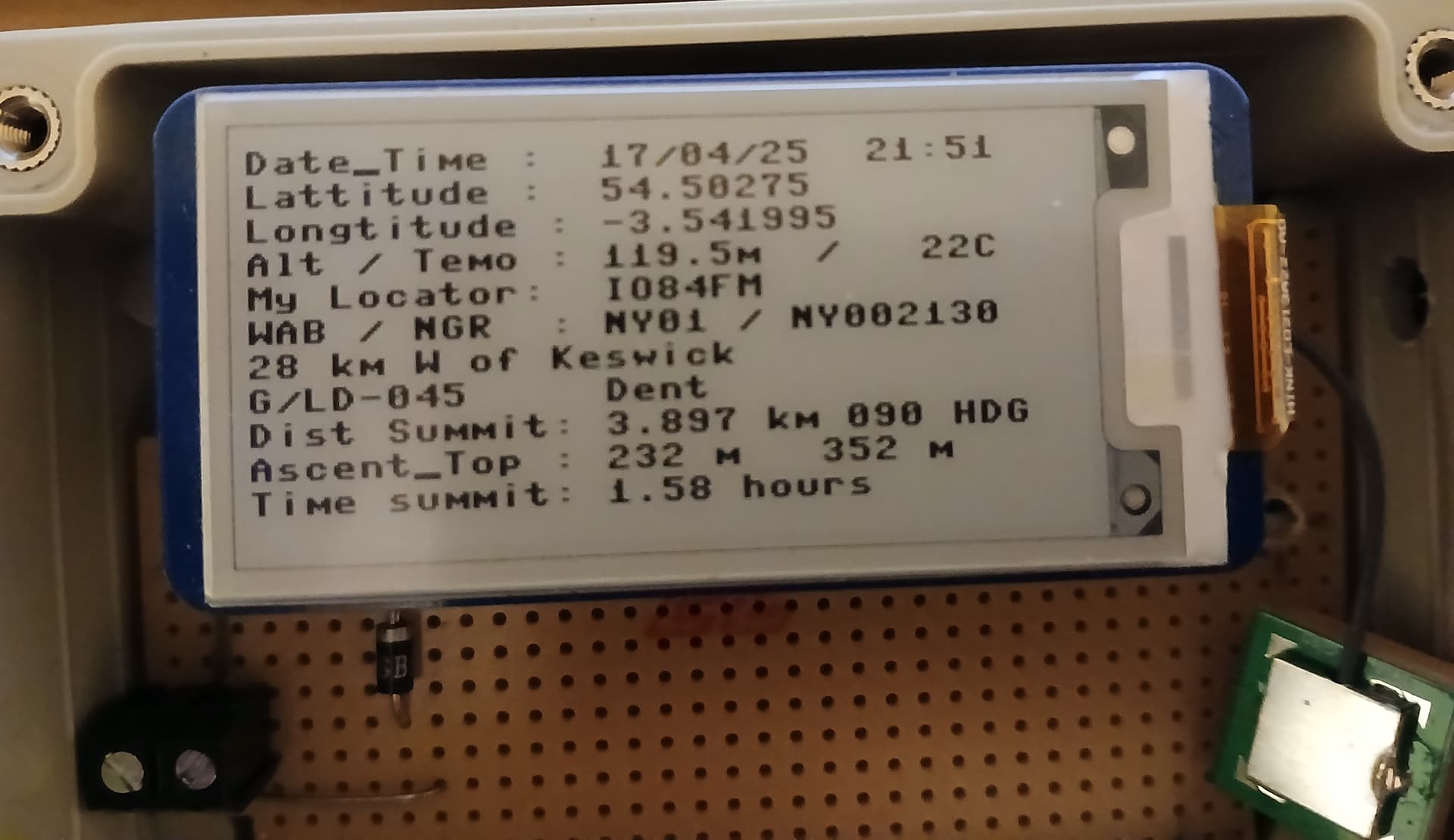
I have been a bit tied down for the past few weeks caring for my 97 year old dad. But as a carer there is a lot of sitting around so I have put it to use with some software projects that have been waiting for a number of years.
One is a GPS that tells you the answer to the questions you get asked when activating SOTAs. Where are you ? How long before you get there ? What is your WAB / Maidenhead ? etc. I want to read the screen in bright daylight so e-paper is the answer…
I have build my own GPS stack using a Pi Pico, and GPS Rx and an e-paper screen,
We have been using Guru Maps on Android with offline OSM maps. If you pay the one-time 40 quid you can load as many maps as you like, but we used the free version for almost 10 years and just deleted a file when we needed capacity for a new region.
However, on one of my first SOTAs we ended up off trail (which forced us into a sketchy scramble) because the phone GPS antenna accuracy is not super accurate.
Now we both carry Garmin eTrex units with free maps at the highest topographic resolution I can get working. The phone is now redundancy.
Pros of the garmin handheld:
AA batteries, and probably 14h runtime on NiMh
(IKEA eneloops).
Waterproof, so it can be viewed at any time.
Much more rugged than a phone.
Daylight viewable screen, unlike a phone.
Better GPS accuracy than a phone.
I like it because I can check my map regularly on an off-trail walk. Taking my phone out is more hassle.
Cons of the garmin handheld:
Harder to navigate screen than a phone.
Less detail than Guru OSM.
I am not very skilled at navigating, I am quite good at getting lost. Having the map on my chest with one button press to turn on the screen is very helpful.
I wish it was easier to load and find good maps for garmin, it is generally a pain and almost none of the tips online actually work.
I do not have the disposable cash to buy high end phones that are waterproof, so I buy a cheap phone and a cheap waterproof GPS and an older waterproof camera.
You can get maps here: https://garmin.opentopomap.org/ but typically the contours are a separate layer. So you download 2 files to the SDCard. If you have a newer Garmin device it sees that one file is a transparent contour map and overlays it on the actual map. If you have an older device you use gmaptool (available for Windows/Mac and Linux) to combine the layers into a single file with something like
An alternative is https://www.freizeitkarte-osm.de which is a German site but it’s in English. My German is just about good enough to know Freizeitkarte is “free-time-maps”. These have been combined already to a single file. They only have maps for Europe however.
Any post 2005 phone should be able to do 10m accuracy without trying. But maybe not in dense woodland.
In practice, I think it’s even better, usually around 3 to 5 meters. That’s more than enough on relatively flat terrain, when hiking, but it can be a bit challenging on tricky routes in steep slopes when mountaineering. I remember struggling one day while descending a 40° slope full of cliffs, where you usually have to zigzag between them. In summer, the path is clear but there is only one option. In winter, the combination of limited positional and altitude accuracy on my gps made it impossible to find the route after the wind had erased all the footprints in the snow. I made it choosing a completely different route, using the detailed map on my phone and sight navigation.
I would say studying the maps, topos, and escape routes before heading out is super important, especially when you’re unfamiliar with the area, whatever navigation system you are using.
That’s not a pro for me. It means I’d need to carry spare AA batteries and a dedicated charger just for this device. I prefer USB-C rechargeable Li-ion batteries, so I can charge all my devices using the same power bank and cable. Not to mention the abysmal energy density of NiMH batteries (around 80 Wh/kg compared to 200 Wh/kg for Li-ion).
… it was bit bulky and had a fairly high power consumption. You always had to have a set of spare batteries with you. But it was great! No map, as Ron @VK3AFW wrote. But very useful for getting to waypoints or finding the way back.
I haven’t switched it on for years, but after reading this, I got it out of the drawer, charged the batteries and turned it on. It still works
Maybe I take it on my next activation just for the fun of it.
There is a local walk that I know ‘like the back of my hand’. On one occasion I left my compass and phone in the car (packing error)… and that is when the fog came down.
Totally disorientated by the poor visibility, it took a while for me to find my way back - if it weren’t for a distinctly shaped boulder (call it natural navigation) I might have been up there for a very long time.
Even if nothing goes wrong, it’s nice to be able to get back to the car in good time to warm up / dry up and stuff yourself with a cream tea. Else, a nice day out can unnecessarily turn into an epic.
Also, on a longer trip (LeJog), I took two smart devices (both loaded with maps), but only used one for Nav. After an ‘off’, it was run over by an articulated lorry. Second device to the rescue.
It definitely pays to have redundancy in some situations.
Of all my cellphones I had, two of them had a cracked screen when I dropped them. My GPs’s one-of-the-1st-Garmins, a Montana 600 and now a 66s, have a much tougher life with rain, and falling, and they keep on ticking.
Just another suggestion to go with a seperate Gps-device.
Then don’t drop them. I think it’s not an argument for needing ‘robust’ dedicated GPS navigation devices instead of a smartphone.
I’ve been using mobile phones for longer than most of you [I use to work for Motorola – inventor of the mobile phone - and had a business-use mobile phone [okay, tiny screen then] when the consumer market was still taking off] and in all the years since I’ve never dropped and cracked or broken my (mainly Apple) smartphone’s screen [Though my adult children did to theirs, more than once!] It’s the same false argument some folk make for avoiding ‘fragile’ rigs like the KX2.
Maybe some of you [under 40?] walk around the streets looking down at your phone, use them whilst sitting on the toilet, etc so you risk dropping them on a hard surface or in the WC water. But on the hills where you need or might need your phone for emergency calls, navigation, etc a little bit of mountaincraft avoids such outcomes, e.g.
When you need to use your phone, stop walking, avoid using it over or near puddles, streams, bogs, etc or on very steep terrain where you might lose your footing (sit or knee down if that helps).
When not using the phone, stow it in an inside zipped jacket pocket preferably in a plastic bag.
The [unlikely] situation where a dense fog descends on you on a local hill, your GPS-based smartphone will help you navigate in very low visibility just as well [maybe even better with its large megapixel colour display] than most standalone GPS devices, and infinitely better if you didn’t bother to take the latter because it was just a familiar local hill walk.
Frankly, the arguments in a few of the preceding posts sound like trying to justify the GPS solution they forked out for.