Ive done that, but not all boundaries are shown, for example the dovestones reservoir one… to me (as im local) it covers a huge area and crosses into the peak district park POTA area aswell (so in theory you could get a double) BUT there is no way of confirming if that area is 100% correct or not! There are others too ive found similarly…
I have however happily found 4 SOTA summits are SOTA/POTAs in the peak district park area! Kinder scout, Black Hill, Shining Tor and Gun so theres something! Hahaha
Andrew, I agree, it seems to me to be going against the spirit of the [POTA] scheme if one wasn’t calling CQ POTA or even knew about it at the time. I think it’s about ranking in league tables.
Rules of the ‘game’ or [unwitting] loopholes?
I only recently came to hear of POTA and it seems a good idea to combine it with my new interest in kite-borne antenna HF radio.
It turns out I live in a POTA park: G-0271 Arnside & Silverdale AoONB (Area of Outstanding National Beauty) though operating from the shack [not being open the public – not yet!] wouldn’t be allowed. And lo and behold, my recent kite-borne antenna tests and QSOs at nearby Gait Barrows Nature Reserve is another, G-0040. And there are three other small POTAs within a few miles of home.
The majority of my SOTA (G/LD & G/NP) and WOTA activations for the last four years were in one of several POTAs but I shan’t retrospectively be entering those QSOs into the POTA scheme.
When the weather improves, given the north American interest in POTA, I might try my kite 40m [Kevlar] EFHW on 20m or make a 20m version for N/A POTA contacts.
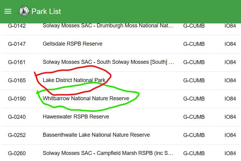
And as the whole Lake District National Park is one park in the programme, G-0165, I should start calling CQ SOTA WOTA POTA …
I was wondering about the Kinder NNR, seems they extended it in 2022, it now covers both the trigs off the Pennine way! the one i was heading for (TP6378 the Edge) when my accident befell me, and the one at kinder low so thats happy days when i get back too it!
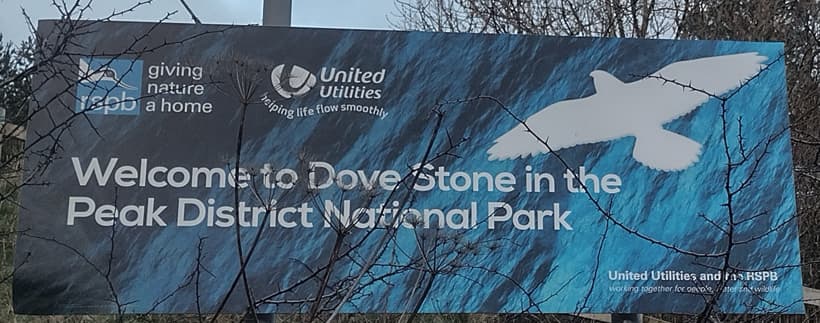
As John has advised, the DEFRA Magic Map is the way to go if looking for most park boundaries; there are some that are not mapped, such as some local parks, but the majority are. You’ll have to play about with the Magic map layers in order to find what you need, so for example with Dove Stone RSPB reserve and the Peak District Park, you will need to enable two lots of mapping layers. It looks like this when you do:
And as you can see, there are a number of sections within the RSPB zone (blue) and the Peak District Park (green line). In fact, very helpfully, some of car park areas beside the dam are in both parks, so it’s a very simple 2fer here.
Generally speaking, most parks will have local printed signs detailing the park boundaries, so you can always check on-site when you get there to see if it counts for 2fer, 3fer etc activations. And these signs make it very easy:
I’d say more it’s about being the incomer into an existing ‘market’:
In the US, where it started, people had been activating in the one-off National Parks on the air events for some time. So it made sense, as that programme rolled into the POTA scheme, to include those past activations.
Coming into a new country such as ZL, where existing national award schemes already existed, a newcomer, such as WWFF which does not allow the past activity in those national schemes to be rolled into the international one face a huge uphill battle. How to convince activators to ‘start again from scratch’ activating the same locations under the new scheme? I’d say that is one of the 3 reasons that POTA has eclipsed WWFF in ZL despite being a later arrival (the other two being coverage and ease of use).
So, whether you agree with the rule or not, I don’t see this as a loophole, but as a deliberate decision made to encourage pre-existing activators to start using the new scheme.
I must be missing something then because I faffed about for the fat end of an hour with Magic maps trying to get something like that… the peak district one is easy, its marked on OS maps, and some of the “small park” POTAs are quite easily defined, but others like this one im struggling with, ill have to try again on Magic, see if i can get a better grip on it… It needs someone with more patience than me to make a list of SOTA/POTAs and what they count for ive done some gw/nw activations andf the only one i can see is a POTA is great Orme (didn’t qualify BTW but will upload at some point).
You are very welcome, thanks for the 10 chase points! Most appreciated pal!
Hello Matt, after reading this reflector almost daily for many years it’s clear to me there’s a wide range of reasons for why folk do SOTA. Put simply it goes from ‘love of walking the hills and the radio is a bonus’ at one end to ‘competitive [almost contest style] radio with league tables’ at the other end.
I’m more towards the former end. So, I’m more than happy to re-activate the majority of those previous hills (points or no points) for the pleasure of it, usually annually for ones in my region.
I concede that the POTA MT might have done this to boost the number of participants. But in my view it devalues the significance of activator league tables and other claims [some even made earlier in this topic].
If you just want a list of POTAs in your area or SOTAs that are in POTAs, you could go the POTA website, select ‘England’, click ‘Locations’ header to sort parks alphabetically by county.
In my example G-0190 contains just one SOTA, Whitbarrow Scar-Lords Seat, whereas G-0165 is the entire Lake District National Park which contains all but 6(?) of the 55 G/LD SOTAs.
Hey @2E0JWA Alan, you only faffed for an hour!? I find the Magic mapping UI pretty poor compared to what we have at work. Trying to remember where they hide all the various layers is a complete pain, but you’ll get there eventually.
You’d think the ‘i’ symbol would identify what is at a particular point, but it only does that if you’ve already selected the correct layers!
Using Bing Maps on the OS mapping layer is another great option for the bigger parks, along with local websites. Many of the SACs/SPAs have links through to an EU database, which does include some decent mapping, but you do have to spend quite a lot of time to find it.
Another option to try is to find previous activators and email them to ask where they set up. Generally I always store photos and map images of parks (and SOTAs) that I/we activate, so I’m happy to share as well.
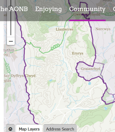
Yea, i get that and the larger parks (Lake district, Peak district, Snowdonia ETC ETC) are pretty obvious! However the smaller parks and RSPB areas ETC are somewhat more difficult! For example Moel Famau is in the Clywydian rang and dee valley AOONB I found out when i googled Moel Famau! I think im getting to grips a little bit with it, it would just be so much easier if all these areas were mapped in a more accessible and standard way! an OS overlay would be the gold standard IMO!
yea, im a fairly impatient person, and an hour was my limit! I came away and went to do something more useful like watching @MM0EFI on youtube! if im honest i need to have another mess with it, but its just BAFFLING! how rubbish it is!
I still don’t get it. Even if you identify, for example, a RSPB reserve in the Magic app, unless it’s declared as a park in the POTA parks list, you can’t operate POTA from there anyway.
Or, is it you have a [e.g.] local RSPB that you want to add to the POTA official list?
Or, is it you are not sure of the boundaries and want to use Magic to ensure you operate within the park?
its finding the boundaries, you want to make sure you are “within” the park to qualify, but alot of the parks are “boundaryless” as it were, and therefore not obvious… take the one I mentioned above. the clywydian and deeside one… Not marked on a single map! (it may be on Magic but its a PITA!) there isnt even one on their own website, so where can i operate from? how many SOTA summits does it Encompass? (definitely 1 potentially 8) but confirming that is difficult! There is the problem!
As far as identifying SOTA summits within POTA parks is concerned, I think that’s a homework exercise individuals will need to do, but it will be straightforward for these smaller POTA parks.
For those activators wishing to do SOTA & POTA simultaneously it would be nice to set up a new thread to which folk can post a list of SOTA summits within POTA parks they know.
Or, even persuade the POTA MT to ‘add an extra column’ [or something similar] listing the SOTAs with each park. Or, vice versa, persuade the SOTA MT to allow adding POTA reference if relevant to SOTA website summits info.
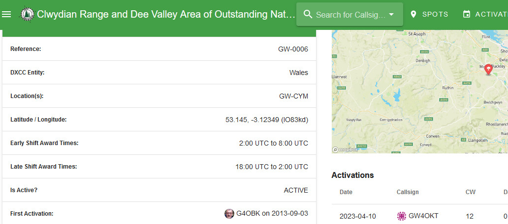
yea, ive actually logged 2 SOTAs from in that area now I found the map you pointed too above on their website! one of them qualified as an activation too (GW/NW-044 Moel Famau) so I was happy with that!
I seem to getting a little more to grips with it now im messing around with it… the MAGIC site is still blooming awful though!
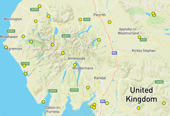
BTW … for anyone who doesn’t want to search through the POTA Parks List by county etc, to see what parks are declared in your target area, try the Parks Map, e.g. near me …
Some are recursive, parks with parks (as others have noted).
Here’s a laugh. Viewing my POTA hunter log for the first time I see I [unwittingly] ‘hunted’ your GW-0006 park in 2021: 2W0TGI/P on 2m FM, no doubt from a local G/LD summit, maybe even a SOTA S2S, but of course POTA doesn’t record those details.