That reminds me of the ‘Four Candles’ sketch…

That reminds me of the ‘Four Candles’ sketch…
The problem’s mostly in the homophones and accent-induced mis-hearings, with a side problem in spelling errors (and probably some due to autocarrot…). W3W claim that such errors should give wildly implausible locations, but the Keswick incidents show that errors can be close enough to be plausible while still being far enough away to be useless, and that this happens often enough for them to mention it in a news item. Given they’re operating in potentially life-or-death situations I’ll let them call the shots, and they’re asking folk to use OS Locate rather than W3W.
I’d guess they’re now stuck in a backwards-compatibility situation where they can’t change the word bank without invalidating who knows how many locations already out there on the Net…
This, too, is a big problem. ( My wife’s German. Her English is a lot better than my German, but we sometimes have interesting mis-understandings… ![]() )
)
However, for me the biggest problem with W3W is that you need a particular very specific app (or an online connection to the website) to convert between three random words and a location. This not a problem you have with lat/long or grid references.
I’d find those (at, typically, two letters and six digits) more robust than three random words, but the use of them was drummed into my brain fifty-something years ago when I was still small and impressionable…
I replied to Gerald MW0WML on Facebook regarding the same topic.
“Part of my research in Audiological medicine was devising a hearing test for young children using speech discrimination. At low levels or in background noise (in this case poor signal) words with the same vowels but different consonants sound exactly the same. Eg “house” and “cow” or “bee” and “key”. It’s more difficult to mix up numbers as they tend to have different vowels. To confuse it more, dialects use different vowel sounds for the same word. Mistakes can be made for both but many possible errors for words, fewer for numbers.”
The emergency services in Northumberland are recommending W3W as their experience is that people needing help in the remote parts of the county have no idea where they are and have great difficulty describing their location. There have been a number of reports of help being successfully delivered by using this.
Jim
Northumberland is always a few years behind.
The Darwin awards come to mind.
I think it is probably “Horses for Courses”. I live in rural Co Durham and believe that quite a lot of locals may struggle to describe their location a few miles from home. One of the farmers was horrified that I might walk in a snowstorm as I would get lost as he would not be able to find his way around beyond his fields…. I suppose in the past if they needed help they would have needed a traditional wire phone line which had a describable location….WTW may well be the least bad current solution. If you are not into navigating which Grid ref do you give? Lat and Long? Degrees and minutes or decimal? Or a grid ref but 4 fig, 6 fig or 8 fig?
I think it is different on a hill in that I would hope that people who choose to be on a mountain can do some basic navigation which by my standards would include grid references…
(PS Durham is probably behind Northumberland)
W3W is clearly usually better than nothing, but in the UK at least one mountain rescue organisation is clearly saying OS Locate is better than W3W.
It was interesting to see the use of NGR in the Helicopter ER programme on television. When the helicopter got close to the location of the casualty there was some comment about the relative inaccuracy of just having 6 figures, but they were close enough for it not to be an issue. If OS Locate produced an 8 figure reference, then it would only increase the chance of inaccuracies in the verbal communication aspect of relaying the information. As it stands, 6 figures seems to be a reasonable balance.
If you use the “share” option in OS locate, it will send a 10 digit GR by text, which avoids any confusion…
Eg right now: “I am here SJ 47515 12429.
Sent at 09:38 am by OS Locate app”.
If you go into “about” then “settings” you can choose how many digits are displayed on the app home view…6 seems to be the default.
There have been times when I was quite proud of knowing my position to within 100m ![]()
The lead developer of the OS Maps app has recently set up a Facebook group in which invited enthusiasts are being encouraged to provide feedback about future development. One thing that has come up more than once is a suggestion to merge the functionality of OS Locate into OS Maps. There is a good chance that it will happen in due course.
Martyn M1MAJ
I hope they also keep OS Locate as a standalone. I haven’t enjoyed using the free version of OS Maps and can’t really justify paying for the full package.
Real Life Example:
Grampian Forest Rally a few weeks back. We get a shout to roll into stage with the doctor and rescue team. Car upside down and down a bank. Driver concussed. Doctor says the guy needs to go to hospital. Rescue Chief asks me to find the nearest ambulance RVP to our location. (Rally control will arrange with ambulance control for a county ambulance to meet with the rescue unit at this point, as ambulances don’t like forest tracks.)
I grab the safety plan, ID the rendezvous point - it’s what3words. I read the words to the crew chief. He copies them wrong and it places him on Mars or something. I read them again. I read them a third time. I then go for a fourth, spelling the word he’s having trouble with. He finally get it. He then presses a button or something that will transfer these over to google maps. There’s no internet in the forest. It doesn’t work.
What a waste of time.
I would have always used an OS grid ref when I lived in England. However, now I’m in the EU, I guess it will have to be Lat/Lon. Is there a preferred format for Lat/Lon? I always assumed I would just read out what the GPS says, but Lat/Lon can be given in different ways. I have a Garmin inReach now, so my position is sent automatically.
73 de OE6FEG
Matt
Good example.
That’s a good argument for having the maps preloaded with the maps for the area or to be safer, the entire country. Then test in airplane mode so it can’t refresh maps online.
Matt, OSGB doesn’t have a monopoly on projected coordinate systems. Folk all around the world use UTM for example (‘U’ for Universal!). Pretty common currency around the EU is UTM or slight variations on it (zones / origins suiting the locality and often using ETRS89 reference datum instead of WGS84 as it’s fixed to the Eurasian plate so you don’t have to worry about things drifting about). You’ll find other systems too.
I believe Austria had its own particular reference datum for a very long while and as I recall that even has its echoes still in Balkans mapping. Have a close look at your paper maps and they’ll for sure tell you somewhere what grid it is they’re using.
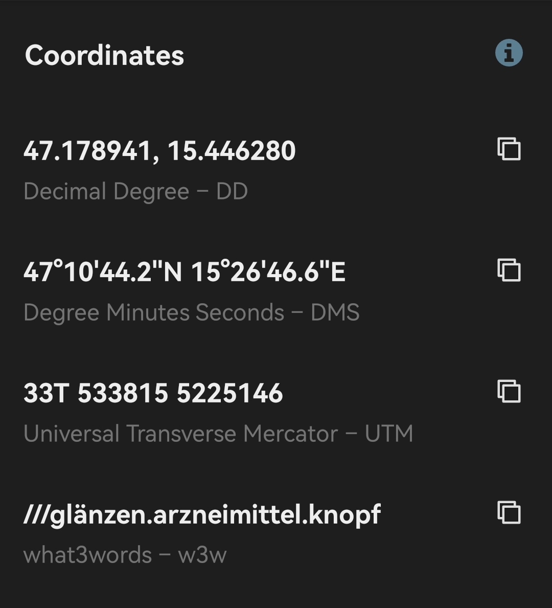
I download the Alpenverein App and had a look at the coordinate system. You get a choice of 4 it seems:
I have written to Bergrettung Steiermark to ask them which one they prefer.
73 Matt
Andrew, Downloading a section of google maps is helpful for finding places, however I’ll never understand why it doesn’t allow full routing when using an off-line map, eg walking or cycling.